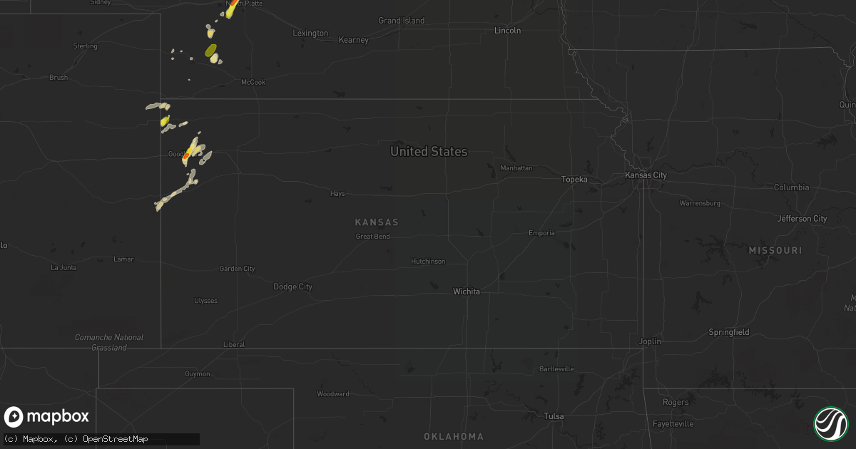
Hail Map in Kansas on August 3, 2018
Get this storm
August 3 map
$229
one time, instant access
Download today. No call, no setup
Keep the $229
Bought the map and want the full workflow? Apply the entire $229 to a subscription within 7 days. None of it is wasted.
Every map, not just this one
This buys you this map. Subscription and you get every map we run, in the markets you choose from a few cities to whole states to nationwide. Plus real-time alerts the moment a storm fires.
Contact data
Name, contact info, occupancy, even credit band for addresses in the footprint. You go from where it hit to who to call.
Become the source they trust
Unlimited branding weather history reports on demand. You already have the documented answer ready for the property owner, and you are the one who showed up with it.
Property data and RoofTrace estimates
Pull up any address you have got, its value and the exact code rules for that jurisdiction, straight from One Click Code. Then RoofTrace estimates the squares, pitch, and roof value, priced the way you price.
Storm reports in Kansas
Kansas
| Date | Description |
|---|---|
| 08/03/20186:54 PM CDT | A wind gust of 76 mph was recorded at 5:49 pm mdt peaking at 90 mph at the sharon springs airport at 5:54 pm mdt. |
| 08/03/20186:15 PM CDT | Reported via facebook. |
| 08/03/20186:00 PM CDT | Public reported via facebook. |
| 08/03/20185:31 PM CDT | A local report indicates 64 MPH wind near 9 N BIRD CITY |
| 08/03/20185:00 PM CDT | A local report indicates 1.00 inch wind near 17 N KANORADO |
| 08/03/201812:14 AM CDT | At 514 PM MDT/614 PM CDT/, a severe thunderstorm was located 9 miles northwest of Brewster, moving northeast at 25 mph. HAZARD...70 mph wind gusts and quarter size hail. SOURCE...Radar indicated. IMPACT...Hail damage to vehicles is expected. Expect considerable tree damage. Wind damage is also likely to mobile homes, roofs, and outbuildings. Locations impacted include... Goodland, Brewster, Levant, McDonald and Edson. This includes Interstate 70 in Kansas between mile markers 20 and 48. |
| 08/03/201812:12 AM CDT | At 511 PM MDT, a severe thunderstorm was located 7 miles northwest of Bristol, or 15 miles northeast of Lamar, moving northeast at 25 mph. HAZARD...70 mph wind gusts and quarter size hail. SOURCE...Radar indicated. IMPACT...Hail damage to vehicles is expected. Expect considerable tree damage. Wind damage is also likely to mobile homes, roofs, and outbuildings. This storm has a history of producing winds of 67 mph. Locations impacted include... Wiley, Sheridan Lake, Brandon, Towner, Bristol and Queens Reservoir. |
| 08/02/201811:49 PM CDT | At 448 PM MDT, a severe thunderstorm was located near Goodland, moving north at 30 mph. HAZARD...60 mph wind gusts and quarter size hail. SOURCE...Radar indicated. IMPACT...Hail damage to vehicles is expected. Expect wind damage to roofs, siding, and trees. Locations impacted include... Goodland and Edson. This includes Interstate 70 in Kansas between mile markers 11 and 34. |
| 08/02/201810:45 PM CDT | At 345 PM MDT/445 PM CDT/, a severe thunderstorm was located 9 miles northeast of Bonny Reservoir, moving northeast at 5 mph. HAZARD...60 mph wind gusts and quarter size hail. SOURCE...Radar indicated. IMPACT...Hail damage to vehicles is expected. Expect wind damage to roofs, siding, and trees. Locations impacted include... St. Francis, Bonny Reservoir, Hale and Wheeler. |
| 08/02/201810:01 PM CDT | At 301 PM MDT, a severe thunderstorm was located 12 miles northwest of Bonny Reservoir, moving east at 10 mph. HAZARD...60 mph wind gusts and quarter size hail. SOURCE...Radar indicated. IMPACT...Hail damage to vehicles is expected. Expect wind damage to roofs, siding, and trees. Locations impacted include... Idalia and Beecher Island. This includes Highway 385 between mile markers 212 and 231. |
| 08/02/20187:00 PM CDT | Corrects previous tstm wnd dmg report from sharon springs. Public sent pictures of a tree uprooted and down in a yard onto the road. Corrected again to include that mor |
All States Impacted by Hail Map on August 3, 2018
Cities Impacted by Hail Map on August 3, 2018
- Fifield, WI
- Park Falls, WI
- Clear Lake, SD
- Cottonwood, MN
- Goodland, KS
- Edson, KS
- Glidden, WI
- Iron Belt, WI
- Upson, WI
- Billings, MT
- Hettinger, ND
- Ellsworth, WI
- Elmwood, WI
- Washburn, WI
- Saint Paul, MN
- Saint Francis, KS
- Livingston, MT
- Saxon, WI
- Hurley, WI
- Rugby, ND
- Pierz, MN
- Hillman, MN
- Durham, NH
- Nottingham, NH
- Lee, NH
- Eau Claire, WI
- Fall Creek, WI
- Altoona, WI
- Hamilton, CO
- Craig, CO
- Barrington, NH
- Madbury, NH
- Lamar, CO
- Hot Springs, SD
- Oral, SD
- Saint Croix Falls, WI
- Balsam Lake, WI
- Woodville, WI
- Baldwin, WI
- Jordan, MN
- New Prague, MN
- Greenville, MO
- River Falls, WI
- Prentice, WI
- Annandale, MN
- Glen Ullin, ND
- Grove City, MN
- White Rock, NM
- Montreal, WI
- Ashland, WI
- Gile, WI
- Beldenville, WI
- Maiden Rock, WI
- Danbury, WI
- Cheneyville, LA
- Saint Landry, LA
- Wilson, WI
- Spring Valley, WI
- Onamia, MN
- Idalia, CO
- Kirk, CO
- Peridot, AZ
- Benkelman, NE
- Phillips, WI
- Avon, MN
- Enders, NE
- Imperial, NE
- Plum City, WI
- Anamoose, ND
- Mellen, WI
- Marengo, WI
- Trego, WI
- Watertown, SD
- North Platte, NE
- Hershey, NE
- Oakes, ND
- Clark, CO
- Benson, MN
- Murdock, MN
- Sunburg, MN
- Elsie, NE
- Ludlow, SD
- Mora, MN
- Pillager, MN
- Nisswa, MN
- Carson, ND
- Eau Galle, WI
- Menomonie, WI
- Madison, MN
- Marietta, MN
- Litchfield, MN
- Dassel, MN
- Darwin, MN
- Scandia, MN
- Forest Lake, MN
- Marine On Saint Croix, MN
- Hugo, MN
- Osceola, WI
- Medford, WI
- Avoca, MI
- Brewster, KS
- Graceville, MN
- Dequincy, LA
- Thompson, UT
- Isle, MN
- Wahkon, MN
- Lemmon, SD
- Minneapolis, MN
- Osseo, MN
- Maple Grove, MN
- Holly, CO
- Revillo, SD
- Milbank, SD
- Appleton, MN
- Bellingham, MN
- Dawson, MN
- Gary, SD
- Oldsmar, FL
- Flasher, ND
- Mandan, ND
- Ville Platte, LA
- Buffalo, SD
- Rosemount, MN
- Holloway, MN
- Montevideo, MN
- Spanish Fork, UT
- Bridger, MT
- Wray, CO
- Dover, NH
- Eden Prairie, MN
- Shakopee, MN
- Burnsville, MN
- Savage, MN
- Hastings, MN
- Inver Grove Heights, MN
- Prior Lake, MN
- Cushing, MN
- Motley, MN
- Drake, ND
- Lodgepole, SD
- Roberts, MT
- East Carbon, UT
- Odessa, MN
- Ainsworth, NE
- Johnstown, NE
- Glencoe, MN
- Hill City, SD
- Weskan, KS
- Arapahoe, CO
- Elgin, ND
- Almont, ND
- Center City, MN
- Weyerhaeuser, WI
- Rice Lake, WI
- Welch, MN
- Brantwood, WI
- Beardsley, MN
- Alzada, MT
- Capitol, MT
- Becker, MN
- Monticello, MN
- Milford, UT
- Palisade, NE
- Wauneta, NE
- New Richmond, WI
- Pine Ridge, SD
- Sebeka, MN
- Lecompte, LA
- Mcclusky, ND
- Lodge Grass, MT
- Karlsruhe, ND
- Brainerd, MN
- Champion, NE
- Hudson, WI
- North Branch, MN
- Pequot Lakes, MN
- Staples, MN
- Baxter, MN
- Santa Fe, NM
- Kimball, MN
- Cokato, MN
- South Haven, MN
- Buffalo, MN
- Maple Lake, MN
- Saint Cloud, MN
- Waite Park, MN
- Rockville, MN
- Cold Spring, MN
- Saint Michael, MN
- Salisbury, NH
- Franklin, NH
- Canterbury, NH
- Belmont, NH
- Gilmanton, NH
- Concord, NH
- Tilton, NH
- Gilmanton Iron Works, NH
- Delmar, NY
- Albany, NY
- Ravena, NY
- Feura Bush, NY
- Selkirk, NY
- Coeymans Hollow, NY
- Glenmont, NY
- Exeland, WI
- Hawkins, WI
- Glen Flora, WI
- Mondovi, WI
- Stanchfield, MN
- Cambridge, MN
- Ortonville, MN
- Sheridan Lake, CO
- Elk Mound, WI
- Wiley, CO
- New Leipzig, ND
- Saint Anthony, ND
- New Salem, ND
- Circle Pines, MN
- High Bridge, WI
- Roberts, WI
- Somerset, WI
- Burwell, NE
- Kennan, WI
- Catawba, WI
- Haugen, WI
- Mikana, WI
- Rib Lake, WI
- Ogema, WI
- Peever, SD
- Canby, MN
- La Pointe, WI
- Mercer, WI
- Winthrop, MN
- Spicer, MN
- New London, MN
- Forest Hill, LA
- Woodworth, LA
- Alexandria, LA
- Watkins, MN
- Greencastle, IN
- Le Sueur, MN
- Westboro, WI
- Spooner, WI
- Hager City, WI
- Prescott, WI
- Le Center, MN
- Shafer, MN
- Star Prairie, WI
- Centuria, WI
- Tryon, NE
- Sutherland, NE
- Sartell, MN
- Saint Joseph, MN
- Atwater, MN
- Pennock, MN
- Watauga, SD
- McNeal, AZ
- Merrill, WI
- Tomahawk, WI
- Denhoff, ND
- Carver, MN
- Lakeville, MN
- New Iberia, LA
- Hulett, WY
- Alva, WY
- Punta Gorda, FL
- Meeker, CO
- Garrison, MN
- Birchwood, WI
- Wallace, NE
- Barron, WI
- Vulcan, MI
- Niagara, WI
- Danvers, MN
- Wallace, KS
- Webster, MN
- Hayes Center, NE
- Washington Court House, OH
- Clinton, MN
- Sharon Springs, KS
- Moorcroft, WY
- Fort Ripley, MN
- Athens, WI
- Butte, NE
- Garita, NM
- Goodrich, ND
- Lindstrom, MN
- Kerkhoven, MN
- Levant, KS
- Yale, MI
- Clarkfield, MN
- McGrath, MN
- Starbuck, MN
- Hancock, MN
- Springview, NE
- Kirklin, IN
- Glenwood, MN
- Buffalo Gap, SD
- Sarona, WI
- Shell Lake, WI
- Cadott, WI
- Bena, MN
- Gallatin Gateway, MT
- Gypsum, CO
- Corona, SD
- Oak Park, MN
- Princeton, MN
- Frankfort, IN
- Sabina, OH
- Goodwin, SD
- Strandburg, SD
- Jamestown, OH
- Howard Lake, MN
- Rensselaer, NY
- Sandstone, MN
- Milaca, MN
- Ogilvie, MN
- Wolbach, NE
- Correll, MN
- Granite Falls, MN
- Butternut, WI
- Rapid River, MI
- Epsom, NH
- Suncook, NH
- Chichester, NH
- Bird City, KS
- Douglas, AZ
- Dickens, NE
- Brownton, MN
- Vernon, CO
- Mount Washington, KY
- Hinckley, MN
- Putney, VT
- Westmoreland, NH
- North Street, MI
- Echo, MN
- Belview, MN
- Hammond, WI
- Glenwood City, WI
- Wayzata, MN
- Long Lake, MN
- Hopkins, MN
- Hamel, MN
- Ragley, LA
- Emigrant, MT
- Sheldon, WI
- Garfield, MN
- Stewart, MN
- Thermopolis, WY
- Worland, WY
- Chokio, MN
- Stillwater, MN
- Amery, WI
- Dresser, WI
- Willernie, MN
- Minong, WI
- Afton, MN
- Draper, UT
- Butte, ND
- Conchas Dam, NM
- Newkirk, NM
- Arkansaw, WI
- Trementina, NM
- Trinchera, CO
- Browerville, MN
- Verndale, MN
- Sacred Heart, MN
- Cottage Grove, MN
- Edgemont, SD
- Wood Lake, MN
- Hanley Falls, MN
- Jeanerette, LA
- Frazee, MN
- Watson, MN
- Milan, MN
- Marcell, MN
- Bismarck, ND
- Crow Agency, MT
- Custer, SD
- Lorman, MS
- Detroit Lakes, MN
- Rolette, ND
- Pelahatchie, MS
- Alton Bay, NH
- Andover, NH
- North Sutton, NH
- Warner, NH


