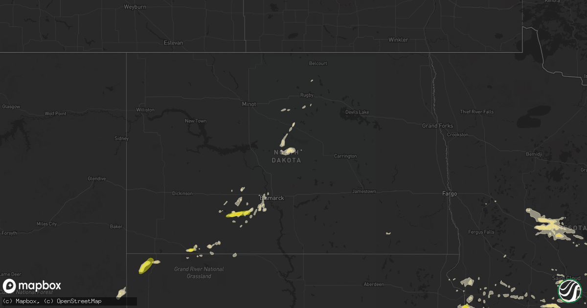
Hail Map in North Dakota on August 3, 2018
Get this storm
August 3 map
$229
one time, instant access
Download today. No call, no setup
Keep the $229
Bought the map and want the full workflow? Apply the entire $229 to a subscription within 7 days. None of it is wasted.
Every map, not just this one
This buys you this map. Subscription and you get every map we run, in the markets you choose from a few cities to whole states to nationwide. Plus real-time alerts the moment a storm fires.
Contact data
Name, contact info, occupancy, even credit band for addresses in the footprint. You go from where it hit to who to call.
Become the source they trust
Unlimited branding weather history reports on demand. You already have the documented answer ready for the property owner, and you are the one who showed up with it.
Property data and RoofTrace estimates
Pull up any address you have got, its value and the exact code rules for that jurisdiction, straight from One Click Code. Then RoofTrace estimates the squares, pitch, and roof value, priced the way you price.
Storm reports in North Dakota
North Dakota
| Date | Description |
|---|---|
| 08/03/20186:47 AM CDT | At 1146 PM CDT/1046 PM MDT/, a severe thunderstorm was located 8 miles south of Fish Creek Dam, or 21 miles southwest of Mandan, moving east at 15 mph. HAZARD...60 mph wind gusts and quarter size hail. SOURCE...Radar indicated. IMPACT...Hail damage to vehicles is expected. Expect wind damage to roofs, siding, and trees. Locations impacted include... St. Anthony. |
| 08/03/20185:46 AM CDT | At 1046 PM CDT/946 PM MDT/, a severe thunderstorm was located 9 miles north of Carson, or 14 miles northeast of Elgin, moving east at 20 mph. HAZARD...60 mph wind gusts and quarter size hail. SOURCE...Radar indicated. IMPACT...Hail damage to vehicles is expected. Expect wind damage to roofs, siding, and trees. Locations impacted include... Fish Creek Dam. |
| 08/03/20185:11 AM CDT | At 1010 PM CDT/910 PM MDT/, a severe thunderstorm was located near Heart Butte Dam, or 14 miles south of Glen Ullin, moving east at 20 mph. HAZARD...60 mph wind gusts and quarter size hail. SOURCE...Radar indicated. IMPACT...Hail damage to vehicles is expected. Expect wind damage to roofs, siding, and trees. Locations impacted include... Heart Butte Dam. |
| 08/03/20183:47 AM CDT | At 846 PM MDT, severe thunderstorms were located along a line extending from 13 miles north of Camp Crook to 2 miles northwest of Gustave to 14 miles north of Colony, moving northeast at 40 mph. HAZARD...70 mph wind gusts and quarter size hail. SOURCE...Radar indicated. IMPACT...Hail damage to vehicles is expected. Expect considerable tree damage. Wind damage is also likely to mobile homes, roofs, and outbuildings. Locations impacted include... Buffalo, Harding, Ludlow, Camp Crook, Gustave, Ladner, Redig, East Short Pines, West Short Pines, Slim Buttes, South Cave Hills, Sheep Buttes, Lake Gardner, Table Mountain, North Cave Hills and Crow Buttes. |
| 08/03/201812:00 AM CDT | Time estimated from radar. |
| 08/02/201811:20 PM CDT | Hail was mainly nickel size... With a few quarters. Wind gusts estimated around 60 mph. Time estimated from radar. |
| 08/02/201811:00 PM CDT | Estimated wind gusts to 70 mph were also with this storm. There was some damage to the house roof and some tree branches were broken. Corn leaves were shredded. Time es |
| 08/02/201810:20 PM CDT | Time estimated from radar. |
| 08/02/201810:10 PM CDT | Time estimated from radar. |
| 08/02/201810:08 PM CDT | Hailing at the time of call. |
All States Impacted by Hail Map on August 3, 2018
Cities Impacted by Hail Map on August 3, 2018
- Fifield, WI
- Park Falls, WI
- Clear Lake, SD
- Cottonwood, MN
- Goodland, KS
- Edson, KS
- Glidden, WI
- Iron Belt, WI
- Upson, WI
- Billings, MT
- Hettinger, ND
- Ellsworth, WI
- Elmwood, WI
- Washburn, WI
- Saint Paul, MN
- Saint Francis, KS
- Livingston, MT
- Saxon, WI
- Hurley, WI
- Rugby, ND
- Pierz, MN
- Hillman, MN
- Durham, NH
- Nottingham, NH
- Lee, NH
- Eau Claire, WI
- Fall Creek, WI
- Altoona, WI
- Hamilton, CO
- Craig, CO
- Barrington, NH
- Madbury, NH
- Lamar, CO
- Hot Springs, SD
- Oral, SD
- Saint Croix Falls, WI
- Balsam Lake, WI
- Woodville, WI
- Baldwin, WI
- Jordan, MN
- New Prague, MN
- Greenville, MO
- River Falls, WI
- Prentice, WI
- Annandale, MN
- Glen Ullin, ND
- Grove City, MN
- White Rock, NM
- Montreal, WI
- Ashland, WI
- Gile, WI
- Beldenville, WI
- Maiden Rock, WI
- Danbury, WI
- Cheneyville, LA
- Saint Landry, LA
- Wilson, WI
- Spring Valley, WI
- Onamia, MN
- Idalia, CO
- Kirk, CO
- Peridot, AZ
- Benkelman, NE
- Phillips, WI
- Avon, MN
- Enders, NE
- Imperial, NE
- Plum City, WI
- Anamoose, ND
- Mellen, WI
- Marengo, WI
- Trego, WI
- Watertown, SD
- North Platte, NE
- Hershey, NE
- Oakes, ND
- Clark, CO
- Benson, MN
- Murdock, MN
- Sunburg, MN
- Elsie, NE
- Ludlow, SD
- Mora, MN
- Pillager, MN
- Nisswa, MN
- Carson, ND
- Eau Galle, WI
- Menomonie, WI
- Madison, MN
- Marietta, MN
- Litchfield, MN
- Dassel, MN
- Darwin, MN
- Scandia, MN
- Forest Lake, MN
- Marine On Saint Croix, MN
- Hugo, MN
- Osceola, WI
- Medford, WI
- Avoca, MI
- Brewster, KS
- Graceville, MN
- Dequincy, LA
- Thompson, UT
- Isle, MN
- Wahkon, MN
- Lemmon, SD
- Minneapolis, MN
- Osseo, MN
- Maple Grove, MN
- Holly, CO
- Revillo, SD
- Milbank, SD
- Appleton, MN
- Bellingham, MN
- Dawson, MN
- Gary, SD
- Oldsmar, FL
- Flasher, ND
- Mandan, ND
- Ville Platte, LA
- Buffalo, SD
- Rosemount, MN
- Holloway, MN
- Montevideo, MN
- Spanish Fork, UT
- Bridger, MT
- Wray, CO
- Dover, NH
- Eden Prairie, MN
- Shakopee, MN
- Burnsville, MN
- Savage, MN
- Hastings, MN
- Inver Grove Heights, MN
- Prior Lake, MN
- Cushing, MN
- Motley, MN
- Drake, ND
- Lodgepole, SD
- Roberts, MT
- East Carbon, UT
- Odessa, MN
- Ainsworth, NE
- Johnstown, NE
- Glencoe, MN
- Hill City, SD
- Weskan, KS
- Arapahoe, CO
- Elgin, ND
- Almont, ND
- Center City, MN
- Weyerhaeuser, WI
- Rice Lake, WI
- Welch, MN
- Brantwood, WI
- Beardsley, MN
- Alzada, MT
- Capitol, MT
- Becker, MN
- Monticello, MN
- Milford, UT
- Palisade, NE
- Wauneta, NE
- New Richmond, WI
- Pine Ridge, SD
- Sebeka, MN
- Lecompte, LA
- Mcclusky, ND
- Lodge Grass, MT
- Karlsruhe, ND
- Brainerd, MN
- Champion, NE
- Hudson, WI
- North Branch, MN
- Pequot Lakes, MN
- Staples, MN
- Baxter, MN
- Santa Fe, NM
- Kimball, MN
- Cokato, MN
- South Haven, MN
- Buffalo, MN
- Maple Lake, MN
- Saint Cloud, MN
- Waite Park, MN
- Rockville, MN
- Cold Spring, MN
- Saint Michael, MN
- Salisbury, NH
- Franklin, NH
- Canterbury, NH
- Belmont, NH
- Gilmanton, NH
- Concord, NH
- Tilton, NH
- Gilmanton Iron Works, NH
- Delmar, NY
- Albany, NY
- Ravena, NY
- Feura Bush, NY
- Selkirk, NY
- Coeymans Hollow, NY
- Glenmont, NY
- Exeland, WI
- Hawkins, WI
- Glen Flora, WI
- Mondovi, WI
- Stanchfield, MN
- Cambridge, MN
- Ortonville, MN
- Sheridan Lake, CO
- Elk Mound, WI
- Wiley, CO
- New Leipzig, ND
- Saint Anthony, ND
- New Salem, ND
- Circle Pines, MN
- High Bridge, WI
- Roberts, WI
- Somerset, WI
- Burwell, NE
- Kennan, WI
- Catawba, WI
- Haugen, WI
- Mikana, WI
- Rib Lake, WI
- Ogema, WI
- Peever, SD
- Canby, MN
- La Pointe, WI
- Mercer, WI
- Winthrop, MN
- Spicer, MN
- New London, MN
- Forest Hill, LA
- Woodworth, LA
- Alexandria, LA
- Watkins, MN
- Greencastle, IN
- Le Sueur, MN
- Westboro, WI
- Spooner, WI
- Hager City, WI
- Prescott, WI
- Le Center, MN
- Shafer, MN
- Star Prairie, WI
- Centuria, WI
- Tryon, NE
- Sutherland, NE
- Sartell, MN
- Saint Joseph, MN
- Atwater, MN
- Pennock, MN
- Watauga, SD
- McNeal, AZ
- Merrill, WI
- Tomahawk, WI
- Denhoff, ND
- Carver, MN
- Lakeville, MN
- New Iberia, LA
- Hulett, WY
- Alva, WY
- Punta Gorda, FL
- Meeker, CO
- Garrison, MN
- Birchwood, WI
- Wallace, NE
- Barron, WI
- Vulcan, MI
- Niagara, WI
- Danvers, MN
- Wallace, KS
- Webster, MN
- Hayes Center, NE
- Washington Court House, OH
- Clinton, MN
- Sharon Springs, KS
- Moorcroft, WY
- Fort Ripley, MN
- Athens, WI
- Butte, NE
- Garita, NM
- Goodrich, ND
- Lindstrom, MN
- Kerkhoven, MN
- Levant, KS
- Yale, MI
- Clarkfield, MN
- McGrath, MN
- Starbuck, MN
- Hancock, MN
- Springview, NE
- Kirklin, IN
- Glenwood, MN
- Buffalo Gap, SD
- Sarona, WI
- Shell Lake, WI
- Cadott, WI
- Bena, MN
- Gallatin Gateway, MT
- Gypsum, CO
- Corona, SD
- Oak Park, MN
- Princeton, MN
- Frankfort, IN
- Sabina, OH
- Goodwin, SD
- Strandburg, SD
- Jamestown, OH
- Howard Lake, MN
- Rensselaer, NY
- Sandstone, MN
- Milaca, MN
- Ogilvie, MN
- Wolbach, NE
- Correll, MN
- Granite Falls, MN
- Butternut, WI
- Rapid River, MI
- Epsom, NH
- Suncook, NH
- Chichester, NH
- Bird City, KS
- Douglas, AZ
- Dickens, NE
- Brownton, MN
- Vernon, CO
- Mount Washington, KY
- Hinckley, MN
- Putney, VT
- Westmoreland, NH
- North Street, MI
- Echo, MN
- Belview, MN
- Hammond, WI
- Glenwood City, WI
- Wayzata, MN
- Long Lake, MN
- Hopkins, MN
- Hamel, MN
- Ragley, LA
- Emigrant, MT
- Sheldon, WI
- Garfield, MN
- Stewart, MN
- Thermopolis, WY
- Worland, WY
- Chokio, MN
- Stillwater, MN
- Amery, WI
- Dresser, WI
- Willernie, MN
- Minong, WI
- Afton, MN
- Draper, UT
- Butte, ND
- Conchas Dam, NM
- Newkirk, NM
- Arkansaw, WI
- Trementina, NM
- Trinchera, CO
- Browerville, MN
- Verndale, MN
- Sacred Heart, MN
- Cottage Grove, MN
- Edgemont, SD
- Wood Lake, MN
- Hanley Falls, MN
- Jeanerette, LA
- Frazee, MN
- Watson, MN
- Milan, MN
- Marcell, MN
- Bismarck, ND
- Crow Agency, MT
- Custer, SD
- Lorman, MS
- Detroit Lakes, MN
- Rolette, ND
- Pelahatchie, MS
- Alton Bay, NH
- Andover, NH
- North Sutton, NH
- Warner, NH


