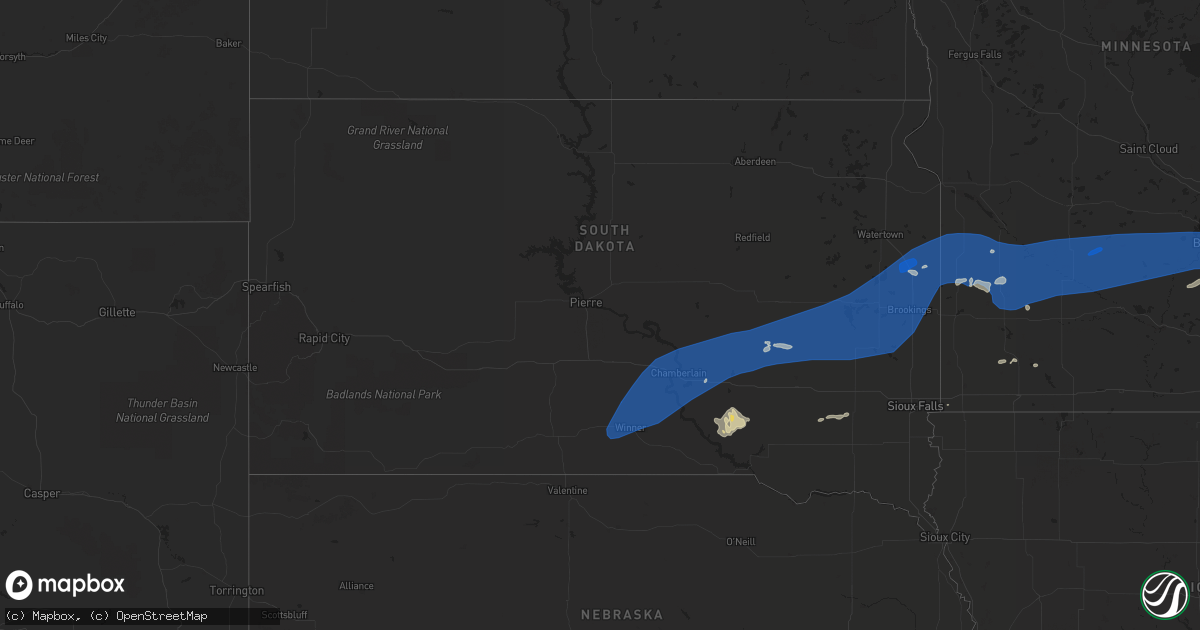
Hail Map in South Dakota on August 2, 2022
Get this storm
August 2 map
$229
one time, instant access
Download today. No call, no setup
Keep the $229
Bought the map and want the full workflow? Apply the entire $229 to a subscription within 7 days. None of it is wasted.
Every map, not just this one
This buys you this map. Subscription and you get every map we run, in the markets you choose from a few cities to whole states to nationwide. Plus real-time alerts the moment a storm fires.
Contact data
Name, contact info, occupancy, even credit band for addresses in the footprint. You go from where it hit to who to call.
Become the source they trust
Unlimited branding weather history reports on demand. You already have the documented answer ready for the property owner, and you are the one who showed up with it.
Property data and RoofTrace estimates
Pull up any address you have got, its value and the exact code rules for that jurisdiction, straight from One Click Code. Then RoofTrace estimates the squares, pitch, and roof value, priced the way you price.
Storm reports in South Dakota
South Dakota
| Date | Description |
|---|---|
| 08/02/20226:59 PM CDT | A local report indicates 63 MPH wind near 11 SW PARMELEE |
| 08/02/20226:57 PM CDT | Time estimated using radar. Reported 67 mph on neighbors personal weather station about 7 pm. Several large cottonwood trees down around town... And a few other reports |
| 08/02/20226:45 PM CDT | Mesonet station ocms2 oacoma 2w |
| 08/02/20226:42 PM CDT | Reported heavy rain... Branches down approximately 3 inches. Screen door ripped off porch. Large dead tree toppled across road... Approximately 20 inches in diameter. |
| 08/02/20226:32 PM CDT | Mesonet station 54 reliance |
| 08/02/20226:10 PM CDT | A local report indicates 64 MPH wind near 4 SSE WITTEN |
| 08/02/20225:57 PM CDT | A local report indicates 72 MPH wind near 1 NE WINNER |
| 08/02/20226:08 AM CDT | At 1108 PM CDT, a severe thunderstorm was located over Dolton, or 11 miles southwest of Lake Vermillion State Recreation Area, moving east at 60 mph. HAZARD...60 mph wind gusts and quarter size hail. SOURCE...Radar indicated. IMPACT...Hail damage to vehicles is expected. Expect wind damage to roofs, siding, and trees. This severe thunderstorm will be near... Monroe around 1115 PM CDT. Parker and Lake Vermillion State Recreation Area around 1120 PM CDT. Humboldt around 1125 PM CDT. Hartford and Wall Lake around 1130 PM CDT. Tea around 1135 PM CDT. |
| 08/02/20224:56 AM CDT | At 955 PM CDT, severe thunderstorms were located along a line extending from near Taunton to near Russell to near Leota, moving east at 60 mph. HAZARD...60 mph wind gusts. Strong gusts are also occurring with the outflow ahead of the rainfall and lightning. SOURCE...Radar indicated. IMPACT...Expect damage to roofs, siding, and trees. Severe thunderstorms will be near... Marshall and Balaton around 1000 PM CDT. Ghent around 1005 PM CDT. Slayton and Tracy around 1010 PM CDT. Fulda, Cottonwood, Currie and Lake Shetek State Park around 1015 PM CDT. Dovray around 1020 PM CDT. Westbrook around 1030 PM CDT. Storden around 1035 PM CDT. Windom and Jeffers around 1040 PM CDT.Other locations impacted by these severe thunderstorms include Ihlen,Avoca, Delft, Lynd, Hadley, Garvin, Iona and Hatfield. |
| 08/02/20223:40 AM CDT | At 840 PM CDT, severe thunderstorms were located along a line extending from near Bryant to Ramona to near Lake Herman State Park, moving east at 60 mph. HAZARD...60 mph wind gusts. The strongest winds are likely occurring ahead of the rain and lightning! SOURCE...Radar indicated. IMPACT...Expect damage to roofs, siding, and trees. Severe thunderstorms will be near... Madison, Lake Herman State Park, Ramona and Orland around 845 PM CDT. Wentworth, Sinai and Nunda around 850 PM CDT. Volga, Arlington, Badger, Chester and Hetland around 855 PM CDT. Brookings, Colman and Lake Poinsett around 900 PM CDT. Aurora, Egan, Trent and Oakwood State Park around 905 PM CDT. Flandreau and Bruce around 910 PM CDT. Elkton, White and Ward around 915 PM CDT.Other locations impacted by these severe thunderstorms includeBancroft, Flandreau Santee Sioux Tribal Nation, Erwin and Bushnell. |
| 08/02/20223:34 AM CDT | At 834 PM CDT, severe thunderstorms were located along a line extending from 9 miles north of Fulton to near Alexandria to 8 miles north of Delmont, moving east at 60 mph. HAZARD...60 mph wind gusts. The strongest winds may be occurring ahead of the rainfall. SOURCE...Radar indicated. IMPACT...Expect damage to roofs, siding, and trees. Severe thunderstorms will be near... Alexandria, Fulton and Farmer around 840 PM CDT. Emery and Spencer In McCook County around 845 PM CDT. Bridgewater, Milltown and Canova around 850 PM CDT. Salem around 855 PM CDT. Lake Vermillion State Recreation Area, Lake Herman State Park, Freeman, Canistota, Montrose, Orland, Clayton and Dolton around 900 PM CDT. |
| 08/02/20222:59 AM CDT | At 759 PM CDT, severe thunderstorms were located along a line extending from 6 miles northwest of Aurora Center to near New Holland to 6 miles northeast of Geddes, moving northeast at 45 mph. HAZARD...60 mph wind gusts. SOURCE...Radar indicated. IMPACT...Expect damage to roofs, siding, and trees. Severe thunderstorms will be near... Plankinton, Armour, Corsica and Stickney around 815 PM CDT. Mount Vernon around 825 PM CDT. Mitchell, Parkston and Loomis around 840 PM CDT. Ethan and Dimock around 845 PM CDT. |
| 08/02/20222:56 AM CDT | At 754 PM CDT, severe thunderstorms were located along a line extending from near Loomis to 10 miles north of Forestburg to near Wolsey, moving northeast at 65 mph. HAZARD...60 mph wind gusts. The strongest winds may be occurring ahead of the rainfall. SOURCE...Radar indicated. IMPACT...Expect damage to roofs, siding, and trees. Severe thunderstorms will be near... Cavour around 805 PM CDT. Huron, Carthage and Yale around 810 PM CDT. Iroquois and Artesian around 815 PM CDT. Fedora and Roswell around 820 PM CDT. Lake Thompson State Recreation Area, De Smet and Vilas around 825 PM CDT. Howard and Lake Preston around 830 PM CDT.Other locations impacted by these severe thunderstorms includeBancroft, Broadland and Erwin. |
| 08/02/20222:23 AM CDT | At 723 PM CDT, severe thunderstorms were located along a line extending from 10 miles northeast of Gann Valley to 13 miles southwest of Wessington Springs to 6 miles south of White Lake, moving northeast at 40 mph. HAZARD...60 mph wind gusts. The strongest winds may be occurring ahead of the rainfall. SOURCE...Radar indicated. IMPACT...Expect damage to roofs, siding, and trees. Severe thunderstorms will be near... Wessington Springs around 740 PM CDT. Plankinton around 745 PM CDT. Lane around 750 PM CDT. Alpena around 755 PM CDT. Woonsocket, Mount Vernon, Virgil and Storla around 800 PM CDT. |
| 08/02/20222:00 AM CDT | At 700 PM CDT, a severe thunderstorm was located over Gann Valley, or 19 miles north of Kimball, moving east at 55 mph. HAZARD...60 mph wind gusts. SOURCE...Radar indicated. IMPACT...Expect damage to roofs, siding, and trees. This severe thunderstorm will remain over mainly rural areas of eastern Buffalo County. |
| 08/02/20221:56 AM CDT | At 655 PM CDT, a severe thunderstorm was located 9 miles east of Chamberlain, moving northeast at 35 mph. HAZARD...60 mph wind gusts. SOURCE...Radar indicated. IMPACT...Expect damage to roofs, siding, and trees. This severe thunderstorm will be near... Grass Ranch Colony around 705 PM CDT. Kimball around 710 PM CDT. White Lake around 725 PM CDT.Other locations impacted by this severe thunderstorm include Pukwana. |
| 08/02/20221:19 AM CDT | At 619 PM CDT, a severe thunderstorm was located 7 miles north of Hamill, or 18 miles west of Chamberlain, moving northeast at 35 mph. HAZARD...60 mph wind gusts. SOURCE...Radar indicated. IMPACT...Expect damage to roofs, siding, and trees. This severe thunderstorm will be near... Lake Francis Case around 635 PM CDT. Chamberlain around 650 PM CDT.Other locations impacted by this severe thunderstorm include Dixon InGregory County and Pukwana. |
| 08/02/20221:17 AM CDT | At 617 PM CDT, severe thunderstorms were located along a line extending from near Medicine Butte to 9 miles southwest of Iona, moving northeast at 35 mph. HAZARD...60 mph wind gusts. SOURCE...Radar indicated. IMPACT...Expect damage to roofs, siding, and trees. Severe thunderstorms will be near... Medicine Butte around 625 PM CDT. Iona around 630 PM CDT. Counselor Creek Boat Access Area around 635 PM CDT.Other locations in the path of these severe thunderstorms includeLake Sharpe, Tailrace Rec Area, Fort Thompson and Lees Corner. |
| 08/01/20229:54 PM CDT | Reported 66 mph gust at 854 pm. |
| 08/01/20229:29 PM CDT | Mesonet station 47 brandt |
| 08/01/20229:15 PM CDT | Mesonet station fw0832 estelline. |
| 08/01/20229:13 PM CDT | A local report indicates 60 MPH wind near 2 SSE STONE BRIDGE |
| 08/01/20229:03 PM CDT | Winds estimated to 60 mph took down numerous tree branches up to 1 to 2 inches in diameter. |
| 08/01/20228:50 PM CDT | A local report indicates 66 MPH wind near 5 N OLDHAM |
| 08/01/20228:20 PM CDT | A local report indicates 70 MPH wind near 1 W HOWARD |
| 08/01/20228:09 PM CDT | Corsica rwis reported 64 mph gust at 8:04 and 8:09. |
| 08/01/20228:05 PM CDT | 6 inch diameter branch down. |
| 08/01/20228:04 PM CDT | Rwis at forrestburg reported 76 mph gusts at 804 and 809 pm. |
| 08/01/20228:00 PM CDT | Reported downed power lines and multiple branches... One 2 ft diameter |
| 08/01/20228:00 PM CDT | Reported rain and strong winds. Winds ripped ceiling panels off pourch. |
| 08/01/20227:10 PM CDT | Time estimated by radar. Reported large dead trees downed... And larger branches... 3-4 inches. |
All States Impacted by Hail Map on August 2, 2022
Cities Impacted by Hail Map on August 2, 2022
- Hayward, WI
- Eveleth, MN
- Gilbert, MN
- Aurora, MN
- Hibbing, MN
- Iron, MN
- Forbes, MN
- Brimson, MN
- Northome, MN
- Prentice, WI
- Channing, MI
- Cable, WI
- Two Harbors, MN
- Winter, WI
- Grand Marais, MI
- Effie, MN
- Sarona, WI
- Spooner, WI
- Pengilly, MN
- Bovey, MN
- Goodland, MN
- Holcombe, WI
- Gilman, WI
- Phillips, WI
- Shevlin, MN
- Thompsonville, MI
- Harrietta, MI
- Bear Lake, MI
- Benzonia, MI
- Frankfort, MI
- Kaleva, MI
- Mesick, MI
- Arcadia, MI
- Beulah, MI
- Brethren, MI
- Onekama, MI
- Copemish, MI
- Blooming Prairie, MN
- Greenwood, WI
- Cook, MN
- Side Lake, MN
- Bigfork, MN
- Chisholm, MN
- Britt, MN
- Nashwauk, MN
- Mountain Iron, MN
- Leroy, MI
- Tustin, MI
- Waltham, MN
- Brownsdale, MN
- Lansing, MN
- Austin, MN
- Fremont, MI
- Sparta, WI
- Ontonagon, MI
- Bessemer, MI
- Wakefield, MI
- Trego, WI
- Minong, WI
- Elmwood, WI
- Ellsworth, WI
- Spring Valley, WI
- Beldenville, WI
- Willow River, MN
- Askov, MN
- Crystal Falls, MI
- Warrens, WI
- Camp Douglas, WI
- Arkdale, WI
- Necedah, WI
- Glidden, WI
- Bayfield, WI
- Westboro, WI
- Rib Lake, WI
- Fall Creek, WI
- Augusta, WI
- Colfax, WI
- Shakopee, MN
- Boyd, MN
- Clarkfield, MN
- Conover, WI
- Cornell, WI
- Thorp, WI
- Withee, WI
- Hoyt Lakes, MN
- Embarrass, MN
- Canyon, MN
- Cotton, MN
- Meadowlands, MN
- Makinen, MN
- Isabella, MN
- Remer, MN
- Deer River, MN
- Rosemount, MN
- Inver Grove Heights, MN
- Ojibwa, WI
- Hampton, MN
- Farmington, MN
- Hastings, MN
- Solon Springs, WI
- Foster City, MI
- Champion, MI
- Aurelia, IA
- Alta, IA
- San Simon, AZ
- Weyerhaeuser, WI
- Chetek, WI
- Fremont, WI
- Poy Sippi, WI
- Winneconne, WI
- Pine River, WI
- Woonsocket, SD
- Big Falls, MN
- Virginia, MN
- Park Falls, WI
- Duluth, MN
- Grygla, MN
- Ivanhoe, MN
- Brandt, SD
- Irwin, ID
- Ririe, ID
- Swan Valley, ID
- West Yellowstone, MT
- Peoria, IL
- Shell Lake, WI
- Frederic, WI
- Hinckley, MN
- Rice Lake, WI
- Barronett, WI
- Webster, WI
- Danbury, WI
- Bruno, MN
- Siren, WI
- Hertel, WI
- Sandstone, MN
- Mondovi, WI
- Eau Claire, WI
- Medford, WI
- Gordon, WI
- Woodruff, WI
- Manton, MI
- Buckley, MI
- Merrill, WI
- Howell, UT
- Lake City, MI
- Fulda, MN
- Owen, WI
- Fife Lake, MI
- East Prairie, MO
- Iona, MN
- Slayton, MN
- Grenada, MS
- Big Rapids, MI
- Stanwood, MI
- White Cloud, MI
- Prescott, WI
- Yreka, CA
- Metamora, IL
- East Peoria, IL
- Osseo, WI
- Crandon, WI
- Pickerel, WI
- Pearson, WI
- Vilonia, AR
- Lovington, IL
- Sullivan, IL
- Bethany, IL
- Dalton City, IL
- Stanley, WI
- Dunlap, IL
- Edelstein, IL
- Chillicothe, IL
- Edgar, WI
- Marathon, WI
- Irons, MI
- Boon, MI
- Cadillac, MI
- Chase, MI
- Reed City, MI
- Wellston, MI
- Luther, MI
- Moweaqua, IL
- Boody, IL
- Decatur, IL
- Macon, IL
- Blue Mound, IL
- Ashburn, GA
- Falcon, MO
- Storm Lake, IA
- Stewart, MS
- Dawson, GA
- Bainbridge, GA
- Neoga, IL
- Strasburg, IL
- Windsor, IL
- Stewardson, IL
- Sigel, IL
- Webster, FL
- Center Hill, FL
- Lake Placid, FL
- Cordele, GA
- Bartow, FL
- Donalsonville, GA
- Carrabelle, FL
- Clermont, FL
- Kissimmee, FL
- Davenport, FL
- Winter Garden, FL
- Snowville, UT
- Tremonton, UT
- Arcadia, FL
- Conrath, WI
- Sheldon, WI
- Kathleen, FL
- Lakeland, FL
- Dade City, FL
- Gays, IL
- Shumway, IL
- Edwards, IL
- Elmwood, IL
- Princeville, IL
- Dahinda, IL
- Williamsfield, IL
- Brimfield, IL
- Laura, IL
- Yates City, IL
- Plumerville, AR
- Bonnots Mill, MO
- Green Valley, IL
- Marble Hill, MO
- Westphalia, MO
- Loose Creek, MO
- Linn, MO
- Moore Haven, FL
- Rockland, MI
- Opelika, AL
- Geneva, FL
- Myakka City, FL
- Jakin, GA
- Central Point, OR
- White City, OR
- Greenview, IL
- Athens, IL
- Eufaula, AL
- Belle, MO
- New Harmony, IN
- Corinne, UT
- Watton, MI
- Mulberry, FL
- Port Saint Lucie, FL
- Mena, AR
- Republic, MI
- Iron River, MI
- Pelkie, MI
- Sidnaw, MI
- Ishpeming, MI
- Michigamme, MI
- Trout Creek, MI
- Covington, MI
- Butternut, WI
- Effingham, IL
- Jackson, TN
- Platte, SD
- New Holland, SD
- Harrison, SD
- Corsica, SD
- Geddes, SD
- White Lake, SD
- Essex, MO
- Bloomfield, MO
- Mattoon, IL
- Millport, AL
- Kennedy, AL
- Vernon, AL
- New Prague, MN
- Le Sueur, MN
- Le Center, MN
- Bruce Crossing, MI
- Mass City, MI
- Clifton, AZ
- Naples, FL
- Pekin, IL
- Randolph, MN
- Cannon Falls, MN
- Dorchester, WI
- Curtiss, WI
- Abbotsford, WI
- El Paso, AR
- Oneida, IL
- Victoria, IL
- Conway, AR
- Jacksonville, IL
- Greensboro, AL
- Charlevoix, MI
- Beaver Island, MI
- Idlewild, MI
- Bitely, MI
- Paris, MI
- Bolivar, TN
- Hoboken, GA
- Meta, MO
- Fort Meade, FL
- Racine, MN
- Dexter, MN
- Stewartville, MN
- Grand Meadow, MN
- Chatfield, MN
- Wykoff, MN
- Spring Valley, MN
- Midway, AL
- Havana, IL
- Lewistown, IL
- Ipava, IL
- Bear Creek, AL
- Haleyville, AL
- Hackleburg, AL
- Canton, IL
- Liverpool, IL
- Saint David, IL
- Topeka, IL
- Cameron, IL
- Gilson, IL
- Galesburg, IL
- Abingdon, IL
- Maquon, IL
- Shorterville, AL
- Abbeville, AL
- Manistee, MI
- Dubois, ID
- Athens, WI
- Franklin, TN
- Northport, AL
- Morton, IL
- Washington, IL
- Deer Creek, IL
- Roseville, IL
- Tony, WI
- Bruce, WI
- Glen Flora, WI
- Ladysmith, WI
- Labelle, FL
- Brandon, FL
- Seffner, FL
- Keno, OR
- Klamath Falls, OR
- Ghent, MN
- Marshall, MN
- Cottonwood, MN
- Heron Lake, MN
- Artesian, SD
- Notasulga, AL
- Gleason, WI
- Irma, WI
- Tomahawk, WI
- Chestnut, IL
- Illiopolis, IL
- Niantic, IL
- Warrensburg, IL
- Kenney, IL
- Beason, IL
- Maroa, IL
- Latham, IL
- Mount Pulaski, IL
- Elgin, AZ
- Tampa, FL
- New Holland, IL
- Hartsburg, IL
- San Jose, IL
- Emden, IL
- Manito, IL
- Altamont, IL
- Tower Hill, IL
- Beecher City, IL
- Mode, IL
- Shelbyville, IL
- Lakewood, IL
- Mason City, IL
- Alva, FL
- Groveland, FL
- Saint Augustine, FL
- Palm Coast, FL
- Winter Haven, FL
- Lake Hamilton, FL
- Haines City, FL
- Dundee, FL
- Boyne City, MI
- Nekoosa, WI
- Eagle Point, OR
- Menomonie, WI
- Colby, WI
- Macomb, IL
- Cuba, IL
- Crocker, MO
- Brumley, MO
- Richland, MO
- Iberia, MO
- Stoutland, MO
- Clewiston, FL
- Black River Falls, WI
- Wheeler, WI
- Bloomer, WI
- Ridgeland, WI
- New Auburn, WI
- Boyd, WI
- Kimball, SD
- Parkston, SD
- Emery, SD
- Boles, AR
- Fayette, AL
- Columbia, AL
- Crawford, MS
- Watson, IL
- Delavan, IL
- Atlanta, IL
- Lincoln, IL
- Hopedale, IL
- Armington, IL
- Minier, IL
- McLean, IL
- Tremont, IL
- Lawndale, IL
- Whigham, GA
- Climax, GA
- Huachuca City, AZ
- Toulon, IL
- La Fayette, IL
- Nebo, NC
- Union Mills, NC
- Punta Gorda, FL
- North Fort Myers, FL
- Charleston, MO
- Vienna, MO
- Owensville, MO
- Bland, MO
- Summerville, GA
- Lincoln, NE
- Davey, NE
- Raymond, NE
- Easton, IL
- Walnut Grove, MN
- Prior Lake, MN
- Eden Prairie, MN
- Minneapolis, MN
- Burnsville, MN
- Savage, MN
- Saint Paul, MN
- Weldon, IA
- Martinsville, MO
- Denver, MO
- Estelline, SD
- Toronto, SD
- Hills, MN
- Hot Springs National Park, AR
- Sonoita, AZ
- Taunton, MN
- Minneota, MN
- Silver Springs, FL
- Bridgewater, SD
- Freeman, SD
- Bowling Green, FL
- Mills, NE
- Stetsonville, WI
- Chippewa Falls, WI
- Fort McCoy, FL
- Citra, FL
- Groveland, IL
- Creve Coeur, IL
- Hanna City, IL
- Mapleton, IL
- Forest City, IL
- Williamsville, IL
- Buffalo, IL
- Kingston Mines, IL
- Middletown, IL
- Farmington, IL
- Bryant, IL
- Elkhart, IL
- Trivoli, IL
- Mount Auburn, IL
- Glasford, IL
- Petersburg, IL
- Riverton, IL
- Fairview, IL
- Omaha, IL
- Cowden, IL
- Orlando, FL
- Polk City, FL
- Fifield, WI
- Jacksonville, OR
- Silver Bay, MN
- Wentworth, SD
- Mendota, MN
- Cologne, MN
- Renville, MN
- Baldwin, WI
- Wabasso, MN
- Marietta, MN
- Belle Plaine, MN
- Bay City, WI
- Lynd, MN
- Waconia, MN
- Ramona, SD
- Redwood Falls, MN
- Winner, SD
- Seaforth, MN
- Arkansaw, WI
- Madison, MN
- Hutchinson, MN
- Hendricks, MN
- Elkton, SD
- Iroquois, SD
- Echo, MN
- Sinai, SD
- Milroy, MN
- Altoona, WI
- Arlington, SD
- Knapp, WI
- Bruce, SD
- Astoria, SD
- Elk Mound, WI
- Carthage, SD
- Aurora, SD
- Badger, SD
- New Auburn, MN
- Danube, MN
- Letcher, SD
- Mound, MN
- Welch, MN
- Cadott, WI
- Saint Bonifacius, MN
- Dallas, SD
- Alpena, SD
- Madison, SD
- Glencoe, MN
- Brownton, MN
- Hamburg, MN
- Lower Brule, SD
- Jim Falls, WI
- Colman, SD
- Chanhassen, MN
- Fort Thompson, SD
- Wessington Springs, SD
- Gregory, SD
- Minnetonka, MN
- Gaylord, MN
- Hamill, SD
- Bird Island, MN
- Hector, MN
- Green Isle, MN
- Young America, MN
- Stewart, MN
- Woodville, WI
- Clements, MN
- Vermillion, MN
- Canova, SD
- Victoria, MN
- Hager City, WI
- Morgan, MN
- Carver, MN
- De Smet, SD
- Fedora, SD
- Norwood Young America, MN
- Pukwana, SD
- Buffalo Lake, MN
- Hanley Falls, MN
- Porter, MN
- Plankinton, SD
- Brookings, SD
- Plato, MN
- Afton, MN
- Oldham, SD
- Huron, SD
- Fairfax, MN
- Reliance, SD
- Presho, SD
- Tracy, MN
- Winthrop, MN
- Wilson, WI
- Cottage Grove, MN
- Oacoma, SD
- Lester Prairie, MN
- Clear Lake, SD
- Silver Lake, MN
- Canby, MN
- Mayer, MN
- Morton, MN
- Durand, WI
- Castlewood, SD
- Dawson, MN
- Rutland, SD
- Henderson, MN
- Belview, MN
- Cavour, SD
- Olivia, MN
- Franklin, MN
- Sacred Heart, MN
- Newport, MN
- South Saint Paul, MN
- Eau Galle, WI
- New Germany, MN
- Lakeville, MN
- Hopkins, MN
- Nunda, SD
- Granite Falls, MN
- Witten, SD
- Wood Lake, MN
- Volga, SD
- Gann Valley, SD
- Mount Vernon, SD
- Gary, SD
- Maiden Rock, WI
- Watertown, MN
- Lake Norden, SD
- White, SD
- Chamberlain, SD
- Excelsior, MN
- Gibbon, MN
- Kennebec, SD
- Plum City, WI
- Lake Preston, SD
- Vesta, MN
- Jordan, MN
- Wayzata, MN
- Chaska, MN
- Burke, SD
- Arlington, MN
- Ideal, SD
- Lucan, MN
- Howard, SD
- Flandreau, SD
- Hammond, WI
- Winfred, SD
- River Falls, WI
- Saint Paul Park, MN
- South Pekin, IL
- Dawson, IL
- Findlay, IL
- Mechanicsburg, IL
- Assumption, IL
- Cerro Gordo, IL
- Oreana, IL
- Mt Zion, IL
- Forsyth, IL
- Clinton, IL
- La Place, IL
- Argenta, IL
- Hammond, IL
- Cisco, IL


