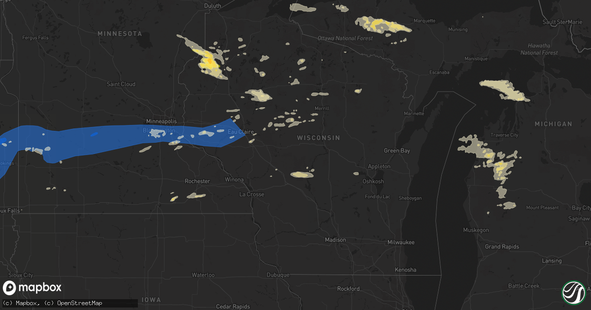
Hail Map in Wisconsin on August 2, 2022
Get this storm
August 2 map
$229
one time, instant access
Download today. No call, no setup
Keep the $229
Bought the map and want the full workflow? Apply the entire $229 to a subscription within 7 days. None of it is wasted.
Every map, not just this one
This buys you this map. Subscription and you get every map we run, in the markets you choose from a few cities to whole states to nationwide. Plus real-time alerts the moment a storm fires.
Contact data
Name, contact info, occupancy, even credit band for addresses in the footprint. You go from where it hit to who to call.
Become the source they trust
Unlimited branding weather history reports on demand. You already have the documented answer ready for the property owner, and you are the one who showed up with it.
Property data and RoofTrace estimates
Pull up any address you have got, its value and the exact code rules for that jurisdiction, straight from One Click Code. Then RoofTrace estimates the squares, pitch, and roof value, priced the way you price.
Storm reports in Wisconsin
Wisconsin
| Date | Description |
|---|---|
| 08/02/20225:40 PM CDT | Peak gust measured at devils island observation site. |
| 08/02/20224:35 PM CDT | Two trees down across east trail on raspberry island. Time estimated by radar. |
| 08/02/20223:45 PM CDT | Corrects location from previous tstm wnd dmg report from 5 ne cornucopia. Tied and weighted down nps canopy tent was thrown and mangled. Time estimated from radar. |
| 08/02/20223:45 PM CDT | Tied and weighted down nps canopy tent was thrown and mangled. Time estimated from radar. |
| 08/02/20226:13 AM CDT | At 1113 PM CDT, severe thunderstorms were located along a line extending from near Rainbow Flowage to Woodboro to near Birch Trails Girl Scout Camp to 11 miles southwest of New Wood Wildlife Area, moving southeast at 45 mph. HAZARD...70 mph wind gusts and penny size hail. SOURCE...Radar indicated. IMPACT...Expect considerable tree damage. Damage is likely to mobile homes, roofs, and outbuildings. Severe thunderstorms will be near... Rhinelander, Merrill and Harrison around 1120 PM CDT. Dutch Corners around 1125 PM CDT. Parrish around 1130 PM CDT.Other locations in the path of these severe thunderstorms includeWausau, Rib Mountain, Veterans Memorial County Park and Antigo. |
| 08/02/20225:30 AM CDT | At 1029 PM CDT, severe thunderstorms were located along a line extending from 7 miles north of Willow Lake to near Prentice to 11 miles south of Catawba, moving southeast at 55 mph. HAZARD...70 mph wind gusts and nickel size hail. SOURCE...Radar indicated. IMPACT...Expect considerable tree damage. Damage is likely to mobile homes, roofs, and outbuildings. Locations impacted include... Rhinelander, Merrill, Tomahawk, Newbold, Harrison, Woodboro, Gilbert, Council Grounds State Park, Tripoli and Dutch Corners. |
| 08/02/20225:20 AM CDT | At 1020 PM CDT, severe thunderstorms were located along a line extending from near Phillips to near Hawkins to 7 miles east of Ladysmith, moving southeast at 40 mph. HAZARD...60 mph wind gusts. SOURCE...Radar indicated. IMPACT...Expect damage to roofs, siding, and trees. Severe thunderstorms will be near... Chelsea and Westboro around 1050 PM CDT. Rib Lake around 1100 PM CDT. Medford around 1115 PM CDT.Other locations impacted by these severe thunderstorms include WoodLake, North Twin Lake, The Mondeaux Flowage, Highway 13 And CountyRoad M, County Roads D And N, Highway M And Joe Martin Road andEsadore Lake. |
| 08/02/20225:11 AM CDT | At 1011 PM CDT, a severe thunderstorm was located 8 miles north of Catawba, or 20 miles south of Park Falls, moving southeast at 40 mph. HAZARD...60 mph wind gusts and penny size hail. SOURCE...Radar indicated. IMPACT...Expect damage to roofs, siding, and trees. This severe thunderstorm will be near... Phillips around 1020 PM CDT. Catawba around 1025 PM CDT.Other locations in the path of this severe thunderstorm includePrentice, Ogema and Spirit. |
| 08/02/20225:09 AM CDT | At 1009 PM CDT, a severe thunderstorm was located near Hawkins, or 14 miles east of Ladysmith, moving southeast at 25 mph. HAZARD...60 mph wind gusts and nickel size hail. SOURCE...Radar indicated. IMPACT...Expect damage to roofs, siding, and trees. This severe thunderstorm will be near... Hawkins around 1015 PM CDT. |
| 08/02/20224:57 AM CDT | At 957 PM CDT, a severe thunderstorm was located near Hertel, or 14 miles southwest of Spooner, moving southeast at 20 mph. HAZARD...Ping pong ball size hail and 60 mph wind gusts. SOURCE...Radar indicated. IMPACT...People and animals outdoors will be injured. Expect hail damage to roofs, siding, windows, and vehicles. Expect wind damage to roofs, siding, and trees. This severe thunderstorm will remain over mainly rural areas of southwestern Washburn and southeastern Burnett Counties, including the following locations... Sarona and Big Sand Lake. |
| 08/02/20224:47 AM CDT | At 947 PM CDT, severe thunderstorms were located along a line extending from 6 miles east of Frederic to 5 miles northeast of Cumberland to 7 miles southeast of Exeland, moving southeast at 25 mph. HAZARD...60 mph wind gusts and quarter size hail. SOURCE...Radar indicated. IMPACT...Hail damage to vehicles is expected. Expect wind damage to roofs, siding, and trees. Severe thunderstorms will be near... Ladysmith around 1005 PM CDT.Other locations in the path of these severe thunderstorms includeRice Lake, Barron, Cameron, Chetek, Turtle Lake and Almena. |
| 08/02/20224:32 AM CDT | At 932 PM CDT, a severe thunderstorm was located near Chippewa Flowage East, moving southeast at 40 mph. HAZARD...70 mph wind gusts and quarter size hail. SOURCE...Radar indicated. IMPACT...Hail damage to vehicles is expected. Expect considerable tree damage. Wind damage is also likely to mobile homes, roofs, and outbuildings. This severe thunderstorm will be near... Winter around 940 PM CDT. |
| 08/02/20223:50 AM CDT | Corrects previous tstm wnd dmg report. Sheriffs office reports tree down over roadway. Time estimated from radar. |
| 08/02/20223:50 AM CDT | Sheriffs office reports tree down over roadway. Time estimated from radar. |
| 08/02/20223:35 AM CDT | Trees down in merrill. |
| 08/02/20223:33 AM CDT | At 832 PM CDT, a severe thunderstorm was located 8 miles west of Cable, or 15 miles north of Hayward, moving southeast at 15 mph. HAZARD...60 mph wind gusts and quarter size hail. SOURCE...Radar indicated. IMPACT...Hail damage to vehicles is expected. Expect wind damage to roofs, siding, and trees. Locations impacted include... Cable, Seeley and Round Lake. |
| 08/02/20223:30 AM CDT | Multiple trees down in the chequamegon national forest across roads. Time estimated from radar. |
| 08/02/20223:25 AM CDT | Tree down over roadway and on power lines. Time estimated from radar. |
| 08/02/20222:55 AM CDT | Trees down across roads and powerlines in hayward. Time estimated from radar. |
| 08/02/20222:55 AM CDT | 60 to 70 foot tall tree 2 feet in diameter snapped off at base. Time estimated via radar. |
| 08/02/20222:30 AM CDT | Time estimated from radar... Officially reported at 8 am with estimated time of occurrence around 3 am. Several reports from across the town. Several trees snapped and |
| 08/02/20222:30 AM CDT | 15 inch diameter tree down in north eau claire. Other downed trees of various size. Time estimated. |
| 08/02/20222:05 AM CDT | Trees down. Time estimated. |
| 08/02/20221:35 AM CDT | Awos station klum menomonie ap. |
| 08/01/202211:35 PM CDT | Trees and power lines down in the city. |
| 08/01/202211:29 PM CDT | At 429 PM CDT, a severe thunderstorm was located near Devils Island, moving east at 35 mph. HAZARD...Ping pong ball size hail and 60 mph wind gusts. SOURCE...Radar indicated. IMPACT...People and animals outdoors will be injured. Expect hail damage to roofs, siding, windows, and vehicles. Expect wind damage to roofs, siding, and trees. This severe thunderstorm will remain over mainly rural areas of northeastern Bayfield and north central Ashland Counties, including the following locations... Stockton Island, Apostle Islands National Lake Shore, Red Cliff Reservation and Outer Island. |
| 08/01/202211:11 PM CDT | 1 tree down in tomahawk |
| 08/01/202211:11 PM CDT | 1 tree down in tomahawk. |
| 08/01/202210:25 PM CDT | Sheriffs department reports tree down over road and powerlines. Time estimated from radar. |
| 08/01/20229:53 PM CDT | Trees across roads and powerlines. Power out. Time estimated from radar. |
| 08/01/20229:45 PM CDT | Poplar tree down across driveway. Time estimated from radar. |
| 08/01/20229:45 PM CDT | Medium size pine tree snapped and fallen on house. Picture submitted on social media. Time estimated from radar. |
| 08/01/20229:42 PM CDT | Report from mping: quarter |
| 08/01/20229:35 PM CDT | Trees across roads throughout the chippewa flowage. Power out. Time estimated from radar. |
| 08/01/20229:15 PM CDT | Numerous tree limbs and trees down. Several trees up to 12 inches in diameter. Time estimated by observer. |
| 08/01/20229:10 PM CDT | 20 inch diameter white pine limb down. Several other limbs down in the area. Power outages as well. Time estimated by radar. |
| 08/01/20229:10 PM CDT | Corrects previous flash flood report from stone lake. Large oak trees uprooted. Report relayed by social media. Time estimated by radar. |
| 08/01/20229:00 PM CDT | Report via social media with picture. |
| 08/01/20228:52 PM CDT | A local report indicates 1.50 inch wind near 5 SW WEBB LAKE |
| 08/01/20228:37 PM CDT | 4 large trees across road. Time estimated from radar. |
| 08/01/20228:30 PM CDT | Time estimated by radar. |
| 08/01/20228:20 PM CDT | Numerous trees down or snapped. Estimates 80 plus trees down on 90 acre property. Neighbors have damage to houses from trees falling on them. Time estimated from radar. |
| 08/01/20228:20 PM CDT | Time estimated from radar. Numerous small to medium sized trees down. Snapped at base and about 20 feet up. Observer reports a narrow swath of damage about 1000 feet wi |
All States Impacted by Hail Map on August 2, 2022
Cities Impacted by Hail Map on August 2, 2022
- Hayward, WI
- Eveleth, MN
- Gilbert, MN
- Aurora, MN
- Hibbing, MN
- Iron, MN
- Forbes, MN
- Brimson, MN
- Northome, MN
- Prentice, WI
- Channing, MI
- Cable, WI
- Two Harbors, MN
- Winter, WI
- Grand Marais, MI
- Effie, MN
- Sarona, WI
- Spooner, WI
- Pengilly, MN
- Bovey, MN
- Goodland, MN
- Holcombe, WI
- Gilman, WI
- Phillips, WI
- Shevlin, MN
- Thompsonville, MI
- Harrietta, MI
- Bear Lake, MI
- Benzonia, MI
- Frankfort, MI
- Kaleva, MI
- Mesick, MI
- Arcadia, MI
- Beulah, MI
- Brethren, MI
- Onekama, MI
- Copemish, MI
- Blooming Prairie, MN
- Greenwood, WI
- Cook, MN
- Side Lake, MN
- Bigfork, MN
- Chisholm, MN
- Britt, MN
- Nashwauk, MN
- Mountain Iron, MN
- Leroy, MI
- Tustin, MI
- Waltham, MN
- Brownsdale, MN
- Lansing, MN
- Austin, MN
- Fremont, MI
- Sparta, WI
- Ontonagon, MI
- Bessemer, MI
- Wakefield, MI
- Trego, WI
- Minong, WI
- Elmwood, WI
- Ellsworth, WI
- Spring Valley, WI
- Beldenville, WI
- Willow River, MN
- Askov, MN
- Crystal Falls, MI
- Warrens, WI
- Camp Douglas, WI
- Arkdale, WI
- Necedah, WI
- Glidden, WI
- Bayfield, WI
- Westboro, WI
- Rib Lake, WI
- Fall Creek, WI
- Augusta, WI
- Colfax, WI
- Shakopee, MN
- Boyd, MN
- Clarkfield, MN
- Conover, WI
- Cornell, WI
- Thorp, WI
- Withee, WI
- Hoyt Lakes, MN
- Embarrass, MN
- Canyon, MN
- Cotton, MN
- Meadowlands, MN
- Makinen, MN
- Isabella, MN
- Remer, MN
- Deer River, MN
- Rosemount, MN
- Inver Grove Heights, MN
- Ojibwa, WI
- Hampton, MN
- Farmington, MN
- Hastings, MN
- Solon Springs, WI
- Foster City, MI
- Champion, MI
- Aurelia, IA
- Alta, IA
- San Simon, AZ
- Weyerhaeuser, WI
- Chetek, WI
- Fremont, WI
- Poy Sippi, WI
- Winneconne, WI
- Pine River, WI
- Woonsocket, SD
- Big Falls, MN
- Virginia, MN
- Park Falls, WI
- Duluth, MN
- Grygla, MN
- Ivanhoe, MN
- Brandt, SD
- Irwin, ID
- Ririe, ID
- Swan Valley, ID
- West Yellowstone, MT
- Peoria, IL
- Shell Lake, WI
- Frederic, WI
- Hinckley, MN
- Rice Lake, WI
- Barronett, WI
- Webster, WI
- Danbury, WI
- Bruno, MN
- Siren, WI
- Hertel, WI
- Sandstone, MN
- Mondovi, WI
- Eau Claire, WI
- Medford, WI
- Gordon, WI
- Woodruff, WI
- Manton, MI
- Buckley, MI
- Merrill, WI
- Howell, UT
- Lake City, MI
- Fulda, MN
- Owen, WI
- Fife Lake, MI
- East Prairie, MO
- Iona, MN
- Slayton, MN
- Grenada, MS
- Big Rapids, MI
- Stanwood, MI
- White Cloud, MI
- Prescott, WI
- Yreka, CA
- Metamora, IL
- East Peoria, IL
- Osseo, WI
- Crandon, WI
- Pickerel, WI
- Pearson, WI
- Vilonia, AR
- Lovington, IL
- Sullivan, IL
- Bethany, IL
- Dalton City, IL
- Stanley, WI
- Dunlap, IL
- Edelstein, IL
- Chillicothe, IL
- Edgar, WI
- Marathon, WI
- Irons, MI
- Boon, MI
- Cadillac, MI
- Chase, MI
- Reed City, MI
- Wellston, MI
- Luther, MI
- Moweaqua, IL
- Boody, IL
- Decatur, IL
- Macon, IL
- Blue Mound, IL
- Ashburn, GA
- Falcon, MO
- Storm Lake, IA
- Stewart, MS
- Dawson, GA
- Bainbridge, GA
- Neoga, IL
- Strasburg, IL
- Windsor, IL
- Stewardson, IL
- Sigel, IL
- Webster, FL
- Center Hill, FL
- Lake Placid, FL
- Cordele, GA
- Bartow, FL
- Donalsonville, GA
- Carrabelle, FL
- Clermont, FL
- Kissimmee, FL
- Davenport, FL
- Winter Garden, FL
- Snowville, UT
- Tremonton, UT
- Arcadia, FL
- Conrath, WI
- Sheldon, WI
- Kathleen, FL
- Lakeland, FL
- Dade City, FL
- Gays, IL
- Shumway, IL
- Edwards, IL
- Elmwood, IL
- Princeville, IL
- Dahinda, IL
- Williamsfield, IL
- Brimfield, IL
- Laura, IL
- Yates City, IL
- Plumerville, AR
- Bonnots Mill, MO
- Green Valley, IL
- Marble Hill, MO
- Westphalia, MO
- Loose Creek, MO
- Linn, MO
- Moore Haven, FL
- Rockland, MI
- Opelika, AL
- Geneva, FL
- Myakka City, FL
- Jakin, GA
- Central Point, OR
- White City, OR
- Greenview, IL
- Athens, IL
- Eufaula, AL
- Belle, MO
- New Harmony, IN
- Corinne, UT
- Watton, MI
- Mulberry, FL
- Port Saint Lucie, FL
- Mena, AR
- Republic, MI
- Iron River, MI
- Pelkie, MI
- Sidnaw, MI
- Ishpeming, MI
- Michigamme, MI
- Trout Creek, MI
- Covington, MI
- Butternut, WI
- Effingham, IL
- Jackson, TN
- Platte, SD
- New Holland, SD
- Harrison, SD
- Corsica, SD
- Geddes, SD
- White Lake, SD
- Essex, MO
- Bloomfield, MO
- Mattoon, IL
- Millport, AL
- Kennedy, AL
- Vernon, AL
- New Prague, MN
- Le Sueur, MN
- Le Center, MN
- Bruce Crossing, MI
- Mass City, MI
- Clifton, AZ
- Naples, FL
- Pekin, IL
- Randolph, MN
- Cannon Falls, MN
- Dorchester, WI
- Curtiss, WI
- Abbotsford, WI
- El Paso, AR
- Oneida, IL
- Victoria, IL
- Conway, AR
- Jacksonville, IL
- Greensboro, AL
- Charlevoix, MI
- Beaver Island, MI
- Idlewild, MI
- Bitely, MI
- Paris, MI
- Bolivar, TN
- Hoboken, GA
- Meta, MO
- Fort Meade, FL
- Racine, MN
- Dexter, MN
- Stewartville, MN
- Grand Meadow, MN
- Chatfield, MN
- Wykoff, MN
- Spring Valley, MN
- Midway, AL
- Havana, IL
- Lewistown, IL
- Ipava, IL
- Bear Creek, AL
- Haleyville, AL
- Hackleburg, AL
- Canton, IL
- Liverpool, IL
- Saint David, IL
- Topeka, IL
- Cameron, IL
- Gilson, IL
- Galesburg, IL
- Abingdon, IL
- Maquon, IL
- Shorterville, AL
- Abbeville, AL
- Manistee, MI
- Dubois, ID
- Athens, WI
- Franklin, TN
- Northport, AL
- Morton, IL
- Washington, IL
- Deer Creek, IL
- Roseville, IL
- Tony, WI
- Bruce, WI
- Glen Flora, WI
- Ladysmith, WI
- Labelle, FL
- Brandon, FL
- Seffner, FL
- Keno, OR
- Klamath Falls, OR
- Ghent, MN
- Marshall, MN
- Cottonwood, MN
- Heron Lake, MN
- Artesian, SD
- Notasulga, AL
- Gleason, WI
- Irma, WI
- Tomahawk, WI
- Chestnut, IL
- Illiopolis, IL
- Niantic, IL
- Warrensburg, IL
- Kenney, IL
- Beason, IL
- Maroa, IL
- Latham, IL
- Mount Pulaski, IL
- Elgin, AZ
- Tampa, FL
- New Holland, IL
- Hartsburg, IL
- San Jose, IL
- Emden, IL
- Manito, IL
- Altamont, IL
- Tower Hill, IL
- Beecher City, IL
- Mode, IL
- Shelbyville, IL
- Lakewood, IL
- Mason City, IL
- Alva, FL
- Groveland, FL
- Saint Augustine, FL
- Palm Coast, FL
- Winter Haven, FL
- Lake Hamilton, FL
- Haines City, FL
- Dundee, FL
- Boyne City, MI
- Nekoosa, WI
- Eagle Point, OR
- Menomonie, WI
- Colby, WI
- Macomb, IL
- Cuba, IL
- Crocker, MO
- Brumley, MO
- Richland, MO
- Iberia, MO
- Stoutland, MO
- Clewiston, FL
- Black River Falls, WI
- Wheeler, WI
- Bloomer, WI
- Ridgeland, WI
- New Auburn, WI
- Boyd, WI
- Kimball, SD
- Parkston, SD
- Emery, SD
- Boles, AR
- Fayette, AL
- Columbia, AL
- Crawford, MS
- Watson, IL
- Delavan, IL
- Atlanta, IL
- Lincoln, IL
- Hopedale, IL
- Armington, IL
- Minier, IL
- McLean, IL
- Tremont, IL
- Lawndale, IL
- Whigham, GA
- Climax, GA
- Huachuca City, AZ
- Toulon, IL
- La Fayette, IL
- Nebo, NC
- Union Mills, NC
- Punta Gorda, FL
- North Fort Myers, FL
- Charleston, MO
- Vienna, MO
- Owensville, MO
- Bland, MO
- Summerville, GA
- Lincoln, NE
- Davey, NE
- Raymond, NE
- Easton, IL
- Walnut Grove, MN
- Prior Lake, MN
- Eden Prairie, MN
- Minneapolis, MN
- Burnsville, MN
- Savage, MN
- Saint Paul, MN
- Weldon, IA
- Martinsville, MO
- Denver, MO
- Estelline, SD
- Toronto, SD
- Hills, MN
- Hot Springs National Park, AR
- Sonoita, AZ
- Taunton, MN
- Minneota, MN
- Silver Springs, FL
- Bridgewater, SD
- Freeman, SD
- Bowling Green, FL
- Mills, NE
- Stetsonville, WI
- Chippewa Falls, WI
- Fort McCoy, FL
- Citra, FL
- Groveland, IL
- Creve Coeur, IL
- Hanna City, IL
- Mapleton, IL
- Forest City, IL
- Williamsville, IL
- Buffalo, IL
- Kingston Mines, IL
- Middletown, IL
- Farmington, IL
- Bryant, IL
- Elkhart, IL
- Trivoli, IL
- Mount Auburn, IL
- Glasford, IL
- Petersburg, IL
- Riverton, IL
- Fairview, IL
- Omaha, IL
- Cowden, IL
- Orlando, FL
- Polk City, FL
- Fifield, WI
- Jacksonville, OR
- Silver Bay, MN
- Wentworth, SD
- Mendota, MN
- Cologne, MN
- Renville, MN
- Baldwin, WI
- Wabasso, MN
- Marietta, MN
- Belle Plaine, MN
- Bay City, WI
- Lynd, MN
- Waconia, MN
- Ramona, SD
- Redwood Falls, MN
- Winner, SD
- Seaforth, MN
- Arkansaw, WI
- Madison, MN
- Hutchinson, MN
- Hendricks, MN
- Elkton, SD
- Iroquois, SD
- Echo, MN
- Sinai, SD
- Milroy, MN
- Altoona, WI
- Arlington, SD
- Knapp, WI
- Bruce, SD
- Astoria, SD
- Elk Mound, WI
- Carthage, SD
- Aurora, SD
- Badger, SD
- New Auburn, MN
- Danube, MN
- Letcher, SD
- Mound, MN
- Welch, MN
- Cadott, WI
- Saint Bonifacius, MN
- Dallas, SD
- Alpena, SD
- Madison, SD
- Glencoe, MN
- Brownton, MN
- Hamburg, MN
- Lower Brule, SD
- Jim Falls, WI
- Colman, SD
- Chanhassen, MN
- Fort Thompson, SD
- Wessington Springs, SD
- Gregory, SD
- Minnetonka, MN
- Gaylord, MN
- Hamill, SD
- Bird Island, MN
- Hector, MN
- Green Isle, MN
- Young America, MN
- Stewart, MN
- Woodville, WI
- Clements, MN
- Vermillion, MN
- Canova, SD
- Victoria, MN
- Hager City, WI
- Morgan, MN
- Carver, MN
- De Smet, SD
- Fedora, SD
- Norwood Young America, MN
- Pukwana, SD
- Buffalo Lake, MN
- Hanley Falls, MN
- Porter, MN
- Plankinton, SD
- Brookings, SD
- Plato, MN
- Afton, MN
- Oldham, SD
- Huron, SD
- Fairfax, MN
- Reliance, SD
- Presho, SD
- Tracy, MN
- Winthrop, MN
- Wilson, WI
- Cottage Grove, MN
- Oacoma, SD
- Lester Prairie, MN
- Clear Lake, SD
- Silver Lake, MN
- Canby, MN
- Mayer, MN
- Morton, MN
- Durand, WI
- Castlewood, SD
- Dawson, MN
- Rutland, SD
- Henderson, MN
- Belview, MN
- Cavour, SD
- Olivia, MN
- Franklin, MN
- Sacred Heart, MN
- Newport, MN
- South Saint Paul, MN
- Eau Galle, WI
- New Germany, MN
- Lakeville, MN
- Hopkins, MN
- Nunda, SD
- Granite Falls, MN
- Witten, SD
- Wood Lake, MN
- Volga, SD
- Gann Valley, SD
- Mount Vernon, SD
- Gary, SD
- Maiden Rock, WI
- Watertown, MN
- Lake Norden, SD
- White, SD
- Chamberlain, SD
- Excelsior, MN
- Gibbon, MN
- Kennebec, SD
- Plum City, WI
- Lake Preston, SD
- Vesta, MN
- Jordan, MN
- Wayzata, MN
- Chaska, MN
- Burke, SD
- Arlington, MN
- Ideal, SD
- Lucan, MN
- Howard, SD
- Flandreau, SD
- Hammond, WI
- Winfred, SD
- River Falls, WI
- Saint Paul Park, MN
- South Pekin, IL
- Dawson, IL
- Findlay, IL
- Mechanicsburg, IL
- Assumption, IL
- Cerro Gordo, IL
- Oreana, IL
- Mt Zion, IL
- Forsyth, IL
- Clinton, IL
- La Place, IL
- Argenta, IL
- Hammond, IL
- Cisco, IL


