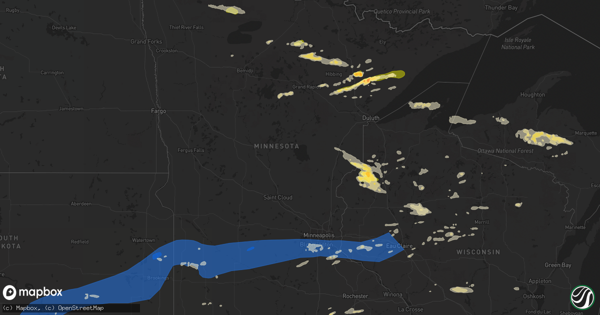
Hail Map in Minnesota on August 2, 2022
Get this storm
August 2 map
$229
one time, instant access
Download today. No call, no setup
Keep the $229
Bought the map and want the full workflow? Apply the entire $229 to a subscription within 7 days. None of it is wasted.
Every map, not just this one
This buys you this map. Subscription and you get every map we run, in the markets you choose from a few cities to whole states to nationwide. Plus real-time alerts the moment a storm fires.
Contact data
Name, contact info, occupancy, even credit band for addresses in the footprint. You go from where it hit to who to call.
Become the source they trust
Unlimited branding weather history reports on demand. You already have the documented answer ready for the property owner, and you are the one who showed up with it.
Property data and RoofTrace estimates
Pull up any address you have got, its value and the exact code rules for that jurisdiction, straight from One Click Code. Then RoofTrace estimates the squares, pitch, and roof value, priced the way you price.
Storm reports in Minnesota
Minnesota
| Date | Description |
|---|---|
| 08/02/20224:00 PM CDT | Report from mping: ping pong ball |
| 08/02/20223:59 PM CDT | Report from mping: ping pong ball |
| 08/02/20223:30 PM CDT | Report via social media. Time estimated from radar. |
| 08/02/20223:30 PM CDT | Report via social media with picture. |
| 08/02/20223:22 PM CDT | Report via social media. |
| 08/02/20223:16 PM CDT | Report via social media with picture. |
| 08/02/20223:15 PM CDT | A local report indicates 1.00 inch wind near 4 SSE MCKINLEY |
| 08/02/20223:06 PM CDT | Report from mping: golf ball |
| 08/02/20223:00 PM CDT | A local report indicates 1.75 inch wind near MAKINEN |
| 08/02/20223:00 PM CDT | Report via social media with picture. |
| 08/02/20227:09 AM CDT | At 1208 PM CDT, a severe thunderstorm was located 7 miles south of Days High Landing, or 12 miles southwest of Grand Rapids, moving east at 25 mph. HAZARD...Half dollar size hail. SOURCE...Radar indicated. IMPACT...Damage to vehicles is expected. This severe thunderstorm will be near... Pokegama Lake around 1225 PM CDT. Cohasset and Pokegama Dam around 1230 PM CDT. Gunn around 1240 PM CDT. Warba around 105 PM CDT. Swan River around 110 PM CDT.Other locations impacted by this severe thunderstorm includeBlackberry, Hart Lake, Calumet, Swan Lake, Bovey, Wawina, Goodland,Marble, Split Hand Lake and Schoolcraft State Park. |
| 08/02/20226:52 AM CDT | At 1152 PM CDT, a severe thunderstorm was located over Victoria, or 19 miles southwest of Minneapolis, moving east at 60 mph. HAZARD...60 mph wind gusts. SOURCE...Radar indicated. IMPACT...Expect damage to roofs, siding, and trees. This severe thunderstorm will be near... Chanhassen and Excelsior around 1155 PM CDT. Eden Prairie, Shakopee and Prior Lake around 1200 AM CDT. Burnsville, Minnetonka, St. Louis Park, Savage and Hopkins around 1205 AM CDT. Edina, Richfield and MSP International Airport around 1210 AM CDT.Other locations in the path of this severe thunderstorm includeBloomington, St. Paul, Eagan, Inver Grove Heights, South St. Paul andWest St. Paul. |
| 08/02/20226:41 AM CDT | At 1141 PM CDT, a severe thunderstorm was located over Ellis, or near Sioux Falls, moving east at 40 mph. HAZARD...60 mph wind gusts and quarter size hail. SOURCE...Radar indicated. IMPACT...Hail damage to vehicles is expected. Expect wind damage to roofs, siding, and trees. This severe thunderstorm will be near... Sioux Falls around 1145 PM CDT. Harrisburg, Crooks and Renner around 1150 PM CDT. Baltic around 1155 PM CDT. Brandon, Corson and Rowena around 1200 AM CDT.Other locations in the path of this severe thunderstorm includePalisades State Park, Garretson and Valley Springs. |
| 08/02/20226:32 AM CDT | At 1131 AM CDT, a severe thunderstorm was located over Boy River, or 22 miles east of Walker, moving northeast at 20 mph. HAZARD...Half dollar size hail. SOURCE...Radar indicated. IMPACT...Damage to vehicles is expected. Locations impacted include... Deer River, Zemple and Days High Landing. |
| 08/02/20226:27 AM CDT | At 1125 PM CDT, a severe thunderstorm was located near Glencoe, or 11 miles southeast of Hutchinson, moving east at 75 mph. THIS IS A DESTRUCTIVE STORM FOR EASTERN MCLEOD AND CARVER COUNTIES. HAZARD...80 mph wind gusts. SOURCE...Radar indicated. Wind gusts as high as 80 mph have occurred with this storm. IMPACT...Flying debris will be dangerous to those caught without shelter. Mobile homes will be heavily damaged. Expect considerable damage to roofs, windows, and vehicles. Extensive tree damage and power outages are likely. This severe thunderstorm will be near... Lester Prairie around 1130 PM CDT. Norwood Young America around 1135 PM CDT. Waconia, Watertown, Mayer and Cologne around 1140 PM CDT. Carver and St. Bonifacius around 1145 PM CDT. Chaska, Chanhassen, Mound, Orono and Victoria around 1150 PM CDT.Other locations impacted by this severe thunderstorm include Loretto,Hollywood, Greenwood, Shorewood, Lake Waconia, Long Lake, Plato, NewGermany, Hamburg and Glencoe Airport. |
| 08/02/20225:53 AM CDT | At 1053 PM CDT, severe thunderstorms were located along a line extending from 5 miles southeast of Prinsburg to near Bird Island to Morton, moving east at 70 mph. HAZARD...70 mph wind gusts. SOURCE...Radar indicated. IMPACT...Expect considerable tree damage. Damage is likely to mobile homes, roofs, and outbuildings. Severe thunderstorms will be near... Fairfax and Hector around 1105 PM CDT. Buffalo Lake and Cosmos around 1110 PM CDT.Other locations in the path of these severe thunderstorms includeGibbon, Stewart, Winthrop, Brownton, Hutchinson, Glencoe, Gaylord andSilver Lake. |
| 08/02/20225:13 AM CDT | At 1012 PM CDT, severe thunderstorms were located along a line extending from near Boyd to 6 miles northeast of Ghent to 7 miles northwest of Tracy, moving east at 60 mph. HAZARD...70 mph wind gusts. A 74 mph gust was reported at Marshall Airport. SOURCE...Radar indicated. IMPACT...Expect considerable tree damage. Damage is likely to mobile homes, roofs, and outbuildings. Severe thunderstorms will be near... Clarkfield around 1020 PM CDT. Montevideo, Wood Lake and Hanley Falls around 1025 PM CDT. Granite Falls and Echo around 1030 PM CDT. Wabasso, Sacred Heart and Maynard around 1035 PM CDT. Clara City around 1040 PM CDT. Redwood Falls and Renville around 1045 PM CDT. |
| 08/02/20224:24 AM CDT | At 923 PM CDT, a severe thunderstorm was located over Brandt, or 8 miles south of Clear Lake, moving east at 50 mph. HAZARD...60 mph wind gusts. SOURCE...Radar indicated. IMPACT...Expect damage to roofs, siding, and trees. Locations impacted include... Canby and Porter. |
| 08/02/20224:18 AM CDT | At 917 PM CDT, a severe thunderstorm was located over Stone Bridge, or 8 miles west of Estelline, moving east at 45 mph. HAZARD...60 mph wind gusts. SOURCE...Radar indicated. IMPACT...Expect damage to roofs, siding, and trees. This severe thunderstorm will be near... Dempster around 925 PM CDT. Estelline and Poinsett Colony around 930 PM CDT.Other locations in the path of this severe thunderstorm include ClearLake, Toronto, Astoria, Brandt, Gary and Lake Cochrane Rec Area. |
| 08/02/20224:13 AM CDT | At 911 PM CDT, severe thunderstorms were located along a line extending from near Bruce to near Aurora to near Trent, moving east at 50 mph. HAZARD...60 mph wind gusts. Strong gusts are also occurring with the outflow ahead of the rainfall and lightning. SOURCE...Radar indicated. IMPACT...Expect damage to roofs, siding, and trees. Severe thunderstorms will be near... Flandreau, Aurora, Egan and Trent around 915 PM CDT. Elkton, White and Ward around 925 PM CDT. Jasper around 930 PM CDT. Pipestone, Lake Benton and Pipestone National Monument around 935 PM CDT. Hendricks, Holland and Trosky around 940 PM CDT. Edgerton, Tyler and Ruthton around 945 PM CDT. Ivanhoe, Woodstock and Florence around 950 PM CDT. Leota, Russell, Arco, Current Lake and Camden State Park around 955 PM CDT.Other locations impacted by these severe thunderstorms include Ihlen,Flandreau Santee Sioux Tribal Nation, Bushnell, Hatfield, Lynd andHadley. |
| 08/02/20223:45 AM CDT | At 844 PM CDT, a severe thunderstorm was located near Webb Lake Wisconsin, or 12 miles northwest of Spooner, moving southeast at 30 mph. HAZARD...60 mph wind gusts and half dollar size hail. SOURCE...Radar indicated. IMPACT...Hail damage to vehicles is expected. Expect wind damage to roofs, siding, and trees. Locations impacted include... Trego, Spooner, Shell Lake and Birchwood. |
| 08/02/20223:05 AM CDT | At 804 PM CDT, a severe thunderstorm was located over Mille Lacs Band Lena Lake Area, or 21 miles east of Hinckley, moving southeast at 40 mph. HAZARD...60 mph wind gusts and quarter size hail. SOURCE...Radar indicated. IMPACT...Hail damage to vehicles is expected. Expect wind damage to roofs, siding, and trees. This severe thunderstorm will be near... Danbury around 815 PM CDT. Webster around 820 PM CDT.Other locations in the path of this severe thunderstorm include WebbLake Wisconsin and Spooner. |
| 08/02/202212:45 AM CDT | Mndot wind sensor near red wing. |
| 08/02/202212:33 AM CDT | Trees and tree branches down. Time estimated. |
| 08/02/202212:31 AM CDT | Some tree damage in the daytons bluff area. Time estimated. |
| 08/02/202212:30 AM CDT | Trees down in a mobile home park. Time estimated. |
| 08/02/202212:23 AM CDT | Asos station kmsp minneapolis-st. Paul ap. |
| 08/02/202212:20 AM CDT | Tree branches down on hennepin ave in uptown minneapolis. Time estimated. |
| 08/02/202212:20 AM CDT | A local report indicates 67 MPH wind near 1 SSW BLOOMINGTON |
| 08/02/202212:15 AM CDT | 10-12 inch diameter trees snapped. Time estimated. |
| 08/02/202212:10 AM CDT | 8 inch branch down. Time estimated by radar. |
| 08/02/202212:08 AM CDT | Several 3 to 5 inch in diameter branches down along rowland rd and the regional trail. Time estimated from radar. |
| 08/01/202211:57 PM CDT | Large tree branches down. |
| 08/01/202211:53 PM CDT | Full size trees down reported on social media in norwood young america. |
| 08/01/202211:45 PM CDT | Numerous large trees down around olivia... Billboard knocked over. Time estimated. |
| 08/01/202211:30 PM CDT | 20in or more diameter/large trees down in hutchinson on houses... In yards... And in the streets. |
| 08/01/202211:25 PM CDT | Trained spotter reported several tree branches larger than 6 inches diameter down. |
| 08/01/202211:20 PM CDT | Photos on social media of medium to large limbs down on roadway. Time estimated by radar. |
| 08/01/202211:19 PM CDT | Khcd - hutchinson airport. |
| 08/01/202211:12 PM CDT | Private weather station. |
| 08/01/202211:10 PM CDT | Hector airport. |
| 08/01/202211:02 PM CDT | Mndot wind sensor west of hector. |
| 08/01/202211:00 PM CDT | At 400 PM CDT, a severe thunderstorm was located over Whyte, or 33 miles south of Ely, moving east at 30 mph. HAZARD...60 mph wind gusts and half dollar size hail. SOURCE...Radar indicated. IMPACT...Hail damage to vehicles is expected. Expect wind damage to roofs, siding, and trees. Locations impacted include... Isabella, Finland, Dumbbell Lake and Clear Lake. |
| 08/01/202210:55 PM CDT | At 355 PM CDT, a severe thunderstorm was located 7 miles northwest of Mountain Iron, or 17 miles northeast of Hibbing, moving east at 45 mph. HAZARD...60 mph wind gusts and quarter size hail. SOURCE...Radar indicated. IMPACT...Hail damage to vehicles is expected. Expect wind damage to roofs, siding, and trees. This severe thunderstorm will be near... Virginia and Mountain Iron around 405 PM CDT. Gilbert around 415 PM CDT.Other locations in the path of this severe thunderstorm includeBiwabik, Aurora, Embarrass and Hoyt Lakes. |
| 08/01/202210:53 PM CDT | Kovl airport. |
| 08/01/202210:53 PM CDT | Asos station krwf redwood falls ap. |
| 08/01/202210:51 PM CDT | Krwf airport. |
| 08/01/202210:37 PM CDT | 60 to 62 mph wind gusts for the last 10 mins at the mndot site near lucan. |
| 08/01/202210:35 PM CDT | Awos station kgdb granite falls ap. |
| 08/01/202210:23 PM CDT | A local report indicates 59 MPH wind near 3 N MILROY |
| 08/01/202210:19 PM CDT | At 319 PM CDT, a severe thunderstorm was located 9 miles south of Togo, or 22 miles northwest of Hibbing, moving east at 45 mph. HAZARD...60 mph wind gusts and half dollar size hail. SOURCE...Radar indicated. IMPACT...Hail damage to vehicles is expected. Expect wind damage to roofs, siding, and trees. Locations impacted include... Mountain Iron. |
| 08/01/202210:14 PM CDT | At 312 PM CDT, severe thunderstorms were located along a line extending from near Aurora, to 7 miles southeast of Hoyt Lakes, to near Wolf Lake, moving northeast at 25 mph. HAZARD...Golf ball size hail and 60 mph wind gusts. SOURCE...Trained weather spotter reported golf ball sized hail near Markham Lake. IMPACT...People and animals outdoors will be injured. Expect hail damage to roofs, siding, windows, and vehicles. Expect wind damage to roofs, siding, and trees. Severe thunderstorms will be near... Fairbanks, Wolf Lake and Brimson around 320 PM CDT.Other locations in the path of these severe thunderstorms includeHoyt Lakes, Babbitt and Whyte. |
| 08/01/202210:10 PM CDT | Badly damaged storage shed at the marshall mn school district cte center. Report via twitter. |
| 08/01/202210:08 PM CDT | Awos station kmml marshall municipal airport. |
| 08/01/202210:06 PM CDT | Medium to large branches reported down in minneota via facebook post. Time estimated via radar. |
| 08/01/202210:05 PM CDT | A local report indicates 65 MPH wind near MINNEOTA |
| 08/01/20229:42 PM CDT | At 241 PM CDT, a severe thunderstorm was located 7 miles southwest of Oaks Corner, or 45 miles southeast of Roseau, moving east at 30 mph. HAZARD...Half dollar size hail. SOURCE...Radar indicated. IMPACT...Damage to vehicles is expected. This severe thunderstorm will be near... Oaks Corner around 250 PM CDT. |
| 08/01/20229:37 PM CDT | At 237 PM CDT, a severe thunderstorm was located 8 miles northeast of Cotton, or 27 miles east of Hibbing, moving east at 25 mph. HAZARD...60 mph wind gusts and quarter size hail. SOURCE...Radar indicated. IMPACT...Hail damage to vehicles is expected. Expect wind damage to roofs, siding, and trees. Locations impacted include... Whiteface Reservoir. |
| 08/01/20229:24 PM CDT | At 224 PM CDT, a severe thunderstorm was located near Effie, moving east at 30 mph. HAZARD...Quarter size hail. SOURCE...Radar indicated. IMPACT...Damage to vehicles is expected. Locations impacted include... Togo. |
| 08/01/20229:04 PM CDT | At 204 PM CDT, a severe thunderstorm was located near Gates Corner, or 33 miles southeast of Roseau, moving east at 30 mph. HAZARD...Ping pong ball size hail. SOURCE...Radar indicated. IMPACT...People and animals outdoors will be injured. Expect damage to roofs, siding, windows, and vehicles. This severe thunderstorm will be near... Gates Corner and Malcolm around 210 PM CDT.Other locations in the path of this severe thunderstorm include OaksCorner. |
All States Impacted by Hail Map on August 2, 2022
Cities Impacted by Hail Map on August 2, 2022
- Hayward, WI
- Eveleth, MN
- Gilbert, MN
- Aurora, MN
- Hibbing, MN
- Iron, MN
- Forbes, MN
- Brimson, MN
- Northome, MN
- Prentice, WI
- Channing, MI
- Cable, WI
- Two Harbors, MN
- Winter, WI
- Grand Marais, MI
- Effie, MN
- Sarona, WI
- Spooner, WI
- Pengilly, MN
- Bovey, MN
- Goodland, MN
- Holcombe, WI
- Gilman, WI
- Phillips, WI
- Shevlin, MN
- Thompsonville, MI
- Harrietta, MI
- Bear Lake, MI
- Benzonia, MI
- Frankfort, MI
- Kaleva, MI
- Mesick, MI
- Arcadia, MI
- Beulah, MI
- Brethren, MI
- Onekama, MI
- Copemish, MI
- Blooming Prairie, MN
- Greenwood, WI
- Cook, MN
- Side Lake, MN
- Bigfork, MN
- Chisholm, MN
- Britt, MN
- Nashwauk, MN
- Mountain Iron, MN
- Leroy, MI
- Tustin, MI
- Waltham, MN
- Brownsdale, MN
- Lansing, MN
- Austin, MN
- Fremont, MI
- Sparta, WI
- Ontonagon, MI
- Bessemer, MI
- Wakefield, MI
- Trego, WI
- Minong, WI
- Elmwood, WI
- Ellsworth, WI
- Spring Valley, WI
- Beldenville, WI
- Willow River, MN
- Askov, MN
- Crystal Falls, MI
- Warrens, WI
- Camp Douglas, WI
- Arkdale, WI
- Necedah, WI
- Glidden, WI
- Bayfield, WI
- Westboro, WI
- Rib Lake, WI
- Fall Creek, WI
- Augusta, WI
- Colfax, WI
- Shakopee, MN
- Boyd, MN
- Clarkfield, MN
- Conover, WI
- Cornell, WI
- Thorp, WI
- Withee, WI
- Hoyt Lakes, MN
- Embarrass, MN
- Canyon, MN
- Cotton, MN
- Meadowlands, MN
- Makinen, MN
- Isabella, MN
- Remer, MN
- Deer River, MN
- Rosemount, MN
- Inver Grove Heights, MN
- Ojibwa, WI
- Hampton, MN
- Farmington, MN
- Hastings, MN
- Solon Springs, WI
- Foster City, MI
- Champion, MI
- Aurelia, IA
- Alta, IA
- San Simon, AZ
- Weyerhaeuser, WI
- Chetek, WI
- Fremont, WI
- Poy Sippi, WI
- Winneconne, WI
- Pine River, WI
- Woonsocket, SD
- Big Falls, MN
- Virginia, MN
- Park Falls, WI
- Duluth, MN
- Grygla, MN
- Ivanhoe, MN
- Brandt, SD
- Irwin, ID
- Ririe, ID
- Swan Valley, ID
- West Yellowstone, MT
- Peoria, IL
- Shell Lake, WI
- Frederic, WI
- Hinckley, MN
- Rice Lake, WI
- Barronett, WI
- Webster, WI
- Danbury, WI
- Bruno, MN
- Siren, WI
- Hertel, WI
- Sandstone, MN
- Mondovi, WI
- Eau Claire, WI
- Medford, WI
- Gordon, WI
- Woodruff, WI
- Manton, MI
- Buckley, MI
- Merrill, WI
- Howell, UT
- Lake City, MI
- Fulda, MN
- Owen, WI
- Fife Lake, MI
- East Prairie, MO
- Iona, MN
- Slayton, MN
- Grenada, MS
- Big Rapids, MI
- Stanwood, MI
- White Cloud, MI
- Prescott, WI
- Yreka, CA
- Metamora, IL
- East Peoria, IL
- Osseo, WI
- Crandon, WI
- Pickerel, WI
- Pearson, WI
- Vilonia, AR
- Lovington, IL
- Sullivan, IL
- Bethany, IL
- Dalton City, IL
- Stanley, WI
- Dunlap, IL
- Edelstein, IL
- Chillicothe, IL
- Edgar, WI
- Marathon, WI
- Irons, MI
- Boon, MI
- Cadillac, MI
- Chase, MI
- Reed City, MI
- Wellston, MI
- Luther, MI
- Moweaqua, IL
- Boody, IL
- Decatur, IL
- Macon, IL
- Blue Mound, IL
- Ashburn, GA
- Falcon, MO
- Storm Lake, IA
- Stewart, MS
- Dawson, GA
- Bainbridge, GA
- Neoga, IL
- Strasburg, IL
- Windsor, IL
- Stewardson, IL
- Sigel, IL
- Webster, FL
- Center Hill, FL
- Lake Placid, FL
- Cordele, GA
- Bartow, FL
- Donalsonville, GA
- Carrabelle, FL
- Clermont, FL
- Kissimmee, FL
- Davenport, FL
- Winter Garden, FL
- Snowville, UT
- Tremonton, UT
- Arcadia, FL
- Conrath, WI
- Sheldon, WI
- Kathleen, FL
- Lakeland, FL
- Dade City, FL
- Gays, IL
- Shumway, IL
- Edwards, IL
- Elmwood, IL
- Princeville, IL
- Dahinda, IL
- Williamsfield, IL
- Brimfield, IL
- Laura, IL
- Yates City, IL
- Plumerville, AR
- Bonnots Mill, MO
- Green Valley, IL
- Marble Hill, MO
- Westphalia, MO
- Loose Creek, MO
- Linn, MO
- Moore Haven, FL
- Rockland, MI
- Opelika, AL
- Geneva, FL
- Myakka City, FL
- Jakin, GA
- Central Point, OR
- White City, OR
- Greenview, IL
- Athens, IL
- Eufaula, AL
- Belle, MO
- New Harmony, IN
- Corinne, UT
- Watton, MI
- Mulberry, FL
- Port Saint Lucie, FL
- Mena, AR
- Republic, MI
- Iron River, MI
- Pelkie, MI
- Sidnaw, MI
- Ishpeming, MI
- Michigamme, MI
- Trout Creek, MI
- Covington, MI
- Butternut, WI
- Effingham, IL
- Jackson, TN
- Platte, SD
- New Holland, SD
- Harrison, SD
- Corsica, SD
- Geddes, SD
- White Lake, SD
- Essex, MO
- Bloomfield, MO
- Mattoon, IL
- Millport, AL
- Kennedy, AL
- Vernon, AL
- New Prague, MN
- Le Sueur, MN
- Le Center, MN
- Bruce Crossing, MI
- Mass City, MI
- Clifton, AZ
- Naples, FL
- Pekin, IL
- Randolph, MN
- Cannon Falls, MN
- Dorchester, WI
- Curtiss, WI
- Abbotsford, WI
- El Paso, AR
- Oneida, IL
- Victoria, IL
- Conway, AR
- Jacksonville, IL
- Greensboro, AL
- Charlevoix, MI
- Beaver Island, MI
- Idlewild, MI
- Bitely, MI
- Paris, MI
- Bolivar, TN
- Hoboken, GA
- Meta, MO
- Fort Meade, FL
- Racine, MN
- Dexter, MN
- Stewartville, MN
- Grand Meadow, MN
- Chatfield, MN
- Wykoff, MN
- Spring Valley, MN
- Midway, AL
- Havana, IL
- Lewistown, IL
- Ipava, IL
- Bear Creek, AL
- Haleyville, AL
- Hackleburg, AL
- Canton, IL
- Liverpool, IL
- Saint David, IL
- Topeka, IL
- Cameron, IL
- Gilson, IL
- Galesburg, IL
- Abingdon, IL
- Maquon, IL
- Shorterville, AL
- Abbeville, AL
- Manistee, MI
- Dubois, ID
- Athens, WI
- Franklin, TN
- Northport, AL
- Morton, IL
- Washington, IL
- Deer Creek, IL
- Roseville, IL
- Tony, WI
- Bruce, WI
- Glen Flora, WI
- Ladysmith, WI
- Labelle, FL
- Brandon, FL
- Seffner, FL
- Keno, OR
- Klamath Falls, OR
- Ghent, MN
- Marshall, MN
- Cottonwood, MN
- Heron Lake, MN
- Artesian, SD
- Notasulga, AL
- Gleason, WI
- Irma, WI
- Tomahawk, WI
- Chestnut, IL
- Illiopolis, IL
- Niantic, IL
- Warrensburg, IL
- Kenney, IL
- Beason, IL
- Maroa, IL
- Latham, IL
- Mount Pulaski, IL
- Elgin, AZ
- Tampa, FL
- New Holland, IL
- Hartsburg, IL
- San Jose, IL
- Emden, IL
- Manito, IL
- Altamont, IL
- Tower Hill, IL
- Beecher City, IL
- Mode, IL
- Shelbyville, IL
- Lakewood, IL
- Mason City, IL
- Alva, FL
- Groveland, FL
- Saint Augustine, FL
- Palm Coast, FL
- Winter Haven, FL
- Lake Hamilton, FL
- Haines City, FL
- Dundee, FL
- Boyne City, MI
- Nekoosa, WI
- Eagle Point, OR
- Menomonie, WI
- Colby, WI
- Macomb, IL
- Cuba, IL
- Crocker, MO
- Brumley, MO
- Richland, MO
- Iberia, MO
- Stoutland, MO
- Clewiston, FL
- Black River Falls, WI
- Wheeler, WI
- Bloomer, WI
- Ridgeland, WI
- New Auburn, WI
- Boyd, WI
- Kimball, SD
- Parkston, SD
- Emery, SD
- Boles, AR
- Fayette, AL
- Columbia, AL
- Crawford, MS
- Watson, IL
- Delavan, IL
- Atlanta, IL
- Lincoln, IL
- Hopedale, IL
- Armington, IL
- Minier, IL
- McLean, IL
- Tremont, IL
- Lawndale, IL
- Whigham, GA
- Climax, GA
- Huachuca City, AZ
- Toulon, IL
- La Fayette, IL
- Nebo, NC
- Union Mills, NC
- Punta Gorda, FL
- North Fort Myers, FL
- Charleston, MO
- Vienna, MO
- Owensville, MO
- Bland, MO
- Summerville, GA
- Lincoln, NE
- Davey, NE
- Raymond, NE
- Easton, IL
- Walnut Grove, MN
- Prior Lake, MN
- Eden Prairie, MN
- Minneapolis, MN
- Burnsville, MN
- Savage, MN
- Saint Paul, MN
- Weldon, IA
- Martinsville, MO
- Denver, MO
- Estelline, SD
- Toronto, SD
- Hills, MN
- Hot Springs National Park, AR
- Sonoita, AZ
- Taunton, MN
- Minneota, MN
- Silver Springs, FL
- Bridgewater, SD
- Freeman, SD
- Bowling Green, FL
- Mills, NE
- Stetsonville, WI
- Chippewa Falls, WI
- Fort McCoy, FL
- Citra, FL
- Groveland, IL
- Creve Coeur, IL
- Hanna City, IL
- Mapleton, IL
- Forest City, IL
- Williamsville, IL
- Buffalo, IL
- Kingston Mines, IL
- Middletown, IL
- Farmington, IL
- Bryant, IL
- Elkhart, IL
- Trivoli, IL
- Mount Auburn, IL
- Glasford, IL
- Petersburg, IL
- Riverton, IL
- Fairview, IL
- Omaha, IL
- Cowden, IL
- Orlando, FL
- Polk City, FL
- Fifield, WI
- Jacksonville, OR
- Silver Bay, MN
- Wentworth, SD
- Mendota, MN
- Cologne, MN
- Renville, MN
- Baldwin, WI
- Wabasso, MN
- Marietta, MN
- Belle Plaine, MN
- Bay City, WI
- Lynd, MN
- Waconia, MN
- Ramona, SD
- Redwood Falls, MN
- Winner, SD
- Seaforth, MN
- Arkansaw, WI
- Madison, MN
- Hutchinson, MN
- Hendricks, MN
- Elkton, SD
- Iroquois, SD
- Echo, MN
- Sinai, SD
- Milroy, MN
- Altoona, WI
- Arlington, SD
- Knapp, WI
- Bruce, SD
- Astoria, SD
- Elk Mound, WI
- Carthage, SD
- Aurora, SD
- Badger, SD
- New Auburn, MN
- Danube, MN
- Letcher, SD
- Mound, MN
- Welch, MN
- Cadott, WI
- Saint Bonifacius, MN
- Dallas, SD
- Alpena, SD
- Madison, SD
- Glencoe, MN
- Brownton, MN
- Hamburg, MN
- Lower Brule, SD
- Jim Falls, WI
- Colman, SD
- Chanhassen, MN
- Fort Thompson, SD
- Wessington Springs, SD
- Gregory, SD
- Minnetonka, MN
- Gaylord, MN
- Hamill, SD
- Bird Island, MN
- Hector, MN
- Green Isle, MN
- Young America, MN
- Stewart, MN
- Woodville, WI
- Clements, MN
- Vermillion, MN
- Canova, SD
- Victoria, MN
- Hager City, WI
- Morgan, MN
- Carver, MN
- De Smet, SD
- Fedora, SD
- Norwood Young America, MN
- Pukwana, SD
- Buffalo Lake, MN
- Hanley Falls, MN
- Porter, MN
- Plankinton, SD
- Brookings, SD
- Plato, MN
- Afton, MN
- Oldham, SD
- Huron, SD
- Fairfax, MN
- Reliance, SD
- Presho, SD
- Tracy, MN
- Winthrop, MN
- Wilson, WI
- Cottage Grove, MN
- Oacoma, SD
- Lester Prairie, MN
- Clear Lake, SD
- Silver Lake, MN
- Canby, MN
- Mayer, MN
- Morton, MN
- Durand, WI
- Castlewood, SD
- Dawson, MN
- Rutland, SD
- Henderson, MN
- Belview, MN
- Cavour, SD
- Olivia, MN
- Franklin, MN
- Sacred Heart, MN
- Newport, MN
- South Saint Paul, MN
- Eau Galle, WI
- New Germany, MN
- Lakeville, MN
- Hopkins, MN
- Nunda, SD
- Granite Falls, MN
- Witten, SD
- Wood Lake, MN
- Volga, SD
- Gann Valley, SD
- Mount Vernon, SD
- Gary, SD
- Maiden Rock, WI
- Watertown, MN
- Lake Norden, SD
- White, SD
- Chamberlain, SD
- Excelsior, MN
- Gibbon, MN
- Kennebec, SD
- Plum City, WI
- Lake Preston, SD
- Vesta, MN
- Jordan, MN
- Wayzata, MN
- Chaska, MN
- Burke, SD
- Arlington, MN
- Ideal, SD
- Lucan, MN
- Howard, SD
- Flandreau, SD
- Hammond, WI
- Winfred, SD
- River Falls, WI
- Saint Paul Park, MN
- South Pekin, IL
- Dawson, IL
- Findlay, IL
- Mechanicsburg, IL
- Assumption, IL
- Cerro Gordo, IL
- Oreana, IL
- Mt Zion, IL
- Forsyth, IL
- Clinton, IL
- La Place, IL
- Argenta, IL
- Hammond, IL
- Cisco, IL


