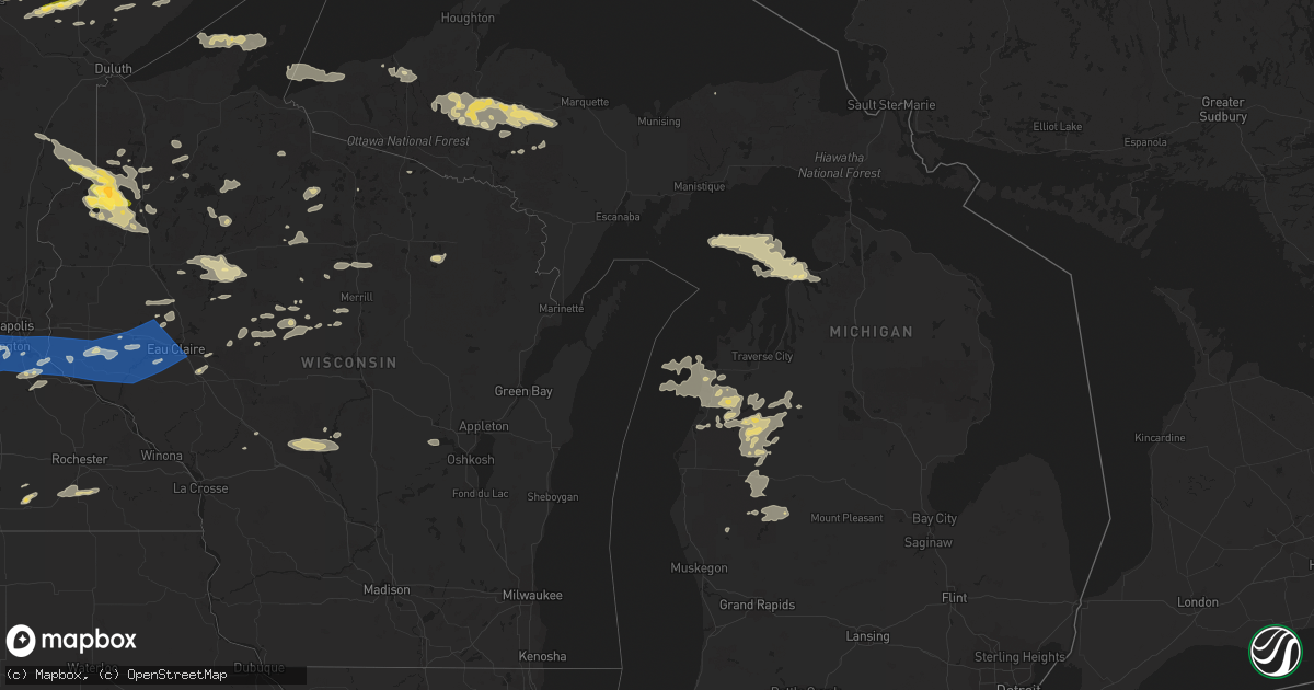
Hail Map in Michigan on August 2, 2022
Get this storm
August 2 map
$229
one time, instant access
Download today. No call, no setup
Keep the $229
Bought the map and want the full workflow? Apply the entire $229 to a subscription within 7 days. None of it is wasted.
Every map, not just this one
This buys you this map. Subscription and you get every map we run, in the markets you choose from a few cities to whole states to nationwide. Plus real-time alerts the moment a storm fires.
Contact data
Name, contact info, occupancy, even credit band for addresses in the footprint. You go from where it hit to who to call.
Become the source they trust
Unlimited branding weather history reports on demand. You already have the documented answer ready for the property owner, and you are the one who showed up with it.
Property data and RoofTrace estimates
Pull up any address you have got, its value and the exact code rules for that jurisdiction, straight from One Click Code. Then RoofTrace estimates the squares, pitch, and roof value, priced the way you price.
Storm reports in Michigan
Michigan
| Date | Description |
|---|---|
| 08/02/20226:00 AM CDT | Local tv meteorologist shared video of large branch falling off of tree from wind on marquette eastside. From twitter. |
| 08/02/20225:59 AM CDT | Power line down at the corner of college and lincoln aves. In the dance zone parking lot. Lots of branches down in the neighborhood. |
| 08/02/20225:59 AM CDT | Lost power due to winds at the time. |
| 08/02/20225:55 AM CDT | Large diameter maple tree snapped near the trunk. Tree damaged a cedar privacy fence at location. |
| 08/02/20225:54 AM CDT | Asos station kimt kingsford. |
| 08/02/20225:07 AM CDT | Corrects time in previous tstm wnd gst report from asos station kimt kingsford station elevation: 1128 ft. |
| 08/02/20224:45 AM CDT | Lost power due to big trees falling down. Has not had power restored yet as of 1122 am edt. From facebook. |
| 08/02/20224:31 AM CDT | At 931 PM EDT/831 PM CDT/, a severe thunderstorm was located near U.S. 141 between Covington and Amasa, or 20 miles north of Crystal Falls, moving east at 45 mph. HAZARD...60 mph wind gusts and quarter size hail. SOURCE...Radar indicated. IMPACT...Hail damage to vehicles is expected. Expect wind damage to roofs, siding, and trees. This severe thunderstorm will remain over mainly rural areas of northeastern Iron and south central Baraga Counties, including the following locations... Ned Lake and Bone Lake. |
| 08/02/20224:26 AM CDT | At 925 PM EDT, a severe thunderstorm was located over Lake Michigamme, or 16 miles west of Ishpeming, moving east at 35 mph. HAZARD...60 mph wind gusts and quarter size hail. SOURCE...Radar indicated. IMPACT...Hail damage to vehicles is expected. Expect wind damage to roofs, siding, and trees. This severe thunderstorm will be near... West Ishpeming around 945 PM EDT. Ishpeming around 950 PM EDT. Negaunee around 955 PM EDT. Marquette and Trowbridge Park around 1010 PM EDT.Other locations impacted by this severe thunderstorm include Palmer,Diorite, Van Riper State Park, Humboldt, National Mine, Big Bass Lakeand Republic. |
| 08/02/20224:01 AM CDT | At 901 PM EDT, a severe thunderstorm was located near Sidnaw, or 20 miles southwest of Baraga, moving east at 35 mph. HAZARD...60 mph wind gusts and quarter size hail. SOURCE...Radar indicated. IMPACT...Hail damage to vehicles is expected. Expect wind damage to roofs, siding, and trees. This severe thunderstorm will be near... Sidnaw around 905 PM EDT. U.S. 141 between Covington and Amasa around 820 PM CDT. Covington around 920 PM EDT. Alberta around 925 PM EDT. Three Lakes around 945 PM EDT.Other locations impacted by this severe thunderstorm include CanyonFalls, Craig Lake State Park, Watton, Echo Lake, Ned Lake and KingLake. |
| 08/02/20223:45 AM CDT | At 844 PM EDT, a severe thunderstorm was located near Covington, or 18 miles south of L'anse, moving east at 35 mph. HAZARD...60 mph wind gusts and quarter size hail. SOURCE...Radar indicated. IMPACT...Hail damage to vehicles is expected. Expect wind damage to roofs, siding, and trees. Locations impacted include... Three Lakes, Michigamme and Lake Michigamme. |
| 08/02/20222:06 AM CDT | At 705 PM EDT/605 PM CDT/, a severe thunderstorm was located near Porcupine Mountains State Park, moving east at 40 mph. HAZARD...60 mph wind gusts and quarter size hail. SOURCE...Radar indicated. IMPACT...Hail damage to vehicles is expected. Expect wind damage to roofs, siding, and trees. This severe thunderstorm will be near... Porcupine Mountains State Park around 710 PM EDT. Silver City around 725 PM EDT.Other locations in the path of this severe thunderstorm includeRockland. |
| 08/01/202210:20 PM CDT | Multiple power outages reported in southern delta county. Main area of outage is from the gladstone area eastward along u.s.41 and u.s.2 to nahma junction. Multiple lig |
| 08/01/20229:10 PM CDT | Multiple power outages are reported in forsyth and richmond townships in marquette county. Event time based on radar. |
| 08/01/20229:06 PM CDT | Law enforcement dispatch reports a power line down across m-35 between chipmunk field and the cataract basin drive west of princeton. Time based on radar. |
| 08/01/20229:06 PM CDT | Marquette county law enforcement dispatch reports large trees and downed wires suspended on other wires around the princeton area west of gwinn along m-35 in forsyth to |
| 08/01/20229:05 PM CDT | Law enforcement reports downed power lines on shag lake drive in forsyth township. Time is estimated from mqt radar. |
| 08/01/20229:00 PM CDT | Report from mping: trees uprooted or snapped. Event time based off mqt radar. |
| 08/01/20229:00 PM CDT | Report from mping: trees uprooted or snapped. Event time based off mqt radar. |
| 08/01/20228:55 PM CDT | Tree down and damaged the power mast of the roof on the northside of west bass lake. Report relayed from wjmntv3 meteorologist. |
| 08/01/20228:11 PM CDT | Michigan dot reports eastbound and westbound lanes of m-28 are closed in kenton due to a downed tree on the highway. Relayed report via social media. |
All States Impacted by Hail Map on August 2, 2022
Cities Impacted by Hail Map on August 2, 2022
- Hayward, WI
- Eveleth, MN
- Gilbert, MN
- Aurora, MN
- Hibbing, MN
- Iron, MN
- Forbes, MN
- Brimson, MN
- Northome, MN
- Prentice, WI
- Channing, MI
- Cable, WI
- Two Harbors, MN
- Winter, WI
- Grand Marais, MI
- Effie, MN
- Sarona, WI
- Spooner, WI
- Pengilly, MN
- Bovey, MN
- Goodland, MN
- Holcombe, WI
- Gilman, WI
- Phillips, WI
- Shevlin, MN
- Thompsonville, MI
- Harrietta, MI
- Bear Lake, MI
- Benzonia, MI
- Frankfort, MI
- Kaleva, MI
- Mesick, MI
- Arcadia, MI
- Beulah, MI
- Brethren, MI
- Onekama, MI
- Copemish, MI
- Blooming Prairie, MN
- Greenwood, WI
- Cook, MN
- Side Lake, MN
- Bigfork, MN
- Chisholm, MN
- Britt, MN
- Nashwauk, MN
- Mountain Iron, MN
- Leroy, MI
- Tustin, MI
- Waltham, MN
- Brownsdale, MN
- Lansing, MN
- Austin, MN
- Fremont, MI
- Sparta, WI
- Ontonagon, MI
- Bessemer, MI
- Wakefield, MI
- Trego, WI
- Minong, WI
- Elmwood, WI
- Ellsworth, WI
- Spring Valley, WI
- Beldenville, WI
- Willow River, MN
- Askov, MN
- Crystal Falls, MI
- Warrens, WI
- Camp Douglas, WI
- Arkdale, WI
- Necedah, WI
- Glidden, WI
- Bayfield, WI
- Westboro, WI
- Rib Lake, WI
- Fall Creek, WI
- Augusta, WI
- Colfax, WI
- Shakopee, MN
- Boyd, MN
- Clarkfield, MN
- Conover, WI
- Cornell, WI
- Thorp, WI
- Withee, WI
- Hoyt Lakes, MN
- Embarrass, MN
- Canyon, MN
- Cotton, MN
- Meadowlands, MN
- Makinen, MN
- Isabella, MN
- Remer, MN
- Deer River, MN
- Rosemount, MN
- Inver Grove Heights, MN
- Ojibwa, WI
- Hampton, MN
- Farmington, MN
- Hastings, MN
- Solon Springs, WI
- Foster City, MI
- Champion, MI
- Aurelia, IA
- Alta, IA
- San Simon, AZ
- Weyerhaeuser, WI
- Chetek, WI
- Fremont, WI
- Poy Sippi, WI
- Winneconne, WI
- Pine River, WI
- Woonsocket, SD
- Big Falls, MN
- Virginia, MN
- Park Falls, WI
- Duluth, MN
- Grygla, MN
- Ivanhoe, MN
- Brandt, SD
- Irwin, ID
- Ririe, ID
- Swan Valley, ID
- West Yellowstone, MT
- Peoria, IL
- Shell Lake, WI
- Frederic, WI
- Hinckley, MN
- Rice Lake, WI
- Barronett, WI
- Webster, WI
- Danbury, WI
- Bruno, MN
- Siren, WI
- Hertel, WI
- Sandstone, MN
- Mondovi, WI
- Eau Claire, WI
- Medford, WI
- Gordon, WI
- Woodruff, WI
- Manton, MI
- Buckley, MI
- Merrill, WI
- Howell, UT
- Lake City, MI
- Fulda, MN
- Owen, WI
- Fife Lake, MI
- East Prairie, MO
- Iona, MN
- Slayton, MN
- Grenada, MS
- Big Rapids, MI
- Stanwood, MI
- White Cloud, MI
- Prescott, WI
- Yreka, CA
- Metamora, IL
- East Peoria, IL
- Osseo, WI
- Crandon, WI
- Pickerel, WI
- Pearson, WI
- Vilonia, AR
- Lovington, IL
- Sullivan, IL
- Bethany, IL
- Dalton City, IL
- Stanley, WI
- Dunlap, IL
- Edelstein, IL
- Chillicothe, IL
- Edgar, WI
- Marathon, WI
- Irons, MI
- Boon, MI
- Cadillac, MI
- Chase, MI
- Reed City, MI
- Wellston, MI
- Luther, MI
- Moweaqua, IL
- Boody, IL
- Decatur, IL
- Macon, IL
- Blue Mound, IL
- Ashburn, GA
- Falcon, MO
- Storm Lake, IA
- Stewart, MS
- Dawson, GA
- Bainbridge, GA
- Neoga, IL
- Strasburg, IL
- Windsor, IL
- Stewardson, IL
- Sigel, IL
- Webster, FL
- Center Hill, FL
- Lake Placid, FL
- Cordele, GA
- Bartow, FL
- Donalsonville, GA
- Carrabelle, FL
- Clermont, FL
- Kissimmee, FL
- Davenport, FL
- Winter Garden, FL
- Snowville, UT
- Tremonton, UT
- Arcadia, FL
- Conrath, WI
- Sheldon, WI
- Kathleen, FL
- Lakeland, FL
- Dade City, FL
- Gays, IL
- Shumway, IL
- Edwards, IL
- Elmwood, IL
- Princeville, IL
- Dahinda, IL
- Williamsfield, IL
- Brimfield, IL
- Laura, IL
- Yates City, IL
- Plumerville, AR
- Bonnots Mill, MO
- Green Valley, IL
- Marble Hill, MO
- Westphalia, MO
- Loose Creek, MO
- Linn, MO
- Moore Haven, FL
- Rockland, MI
- Opelika, AL
- Geneva, FL
- Myakka City, FL
- Jakin, GA
- Central Point, OR
- White City, OR
- Greenview, IL
- Athens, IL
- Eufaula, AL
- Belle, MO
- New Harmony, IN
- Corinne, UT
- Watton, MI
- Mulberry, FL
- Port Saint Lucie, FL
- Mena, AR
- Republic, MI
- Iron River, MI
- Pelkie, MI
- Sidnaw, MI
- Ishpeming, MI
- Michigamme, MI
- Trout Creek, MI
- Covington, MI
- Butternut, WI
- Effingham, IL
- Jackson, TN
- Platte, SD
- New Holland, SD
- Harrison, SD
- Corsica, SD
- Geddes, SD
- White Lake, SD
- Essex, MO
- Bloomfield, MO
- Mattoon, IL
- Millport, AL
- Kennedy, AL
- Vernon, AL
- New Prague, MN
- Le Sueur, MN
- Le Center, MN
- Bruce Crossing, MI
- Mass City, MI
- Clifton, AZ
- Naples, FL
- Pekin, IL
- Randolph, MN
- Cannon Falls, MN
- Dorchester, WI
- Curtiss, WI
- Abbotsford, WI
- El Paso, AR
- Oneida, IL
- Victoria, IL
- Conway, AR
- Jacksonville, IL
- Greensboro, AL
- Charlevoix, MI
- Beaver Island, MI
- Idlewild, MI
- Bitely, MI
- Paris, MI
- Bolivar, TN
- Hoboken, GA
- Meta, MO
- Fort Meade, FL
- Racine, MN
- Dexter, MN
- Stewartville, MN
- Grand Meadow, MN
- Chatfield, MN
- Wykoff, MN
- Spring Valley, MN
- Midway, AL
- Havana, IL
- Lewistown, IL
- Ipava, IL
- Bear Creek, AL
- Haleyville, AL
- Hackleburg, AL
- Canton, IL
- Liverpool, IL
- Saint David, IL
- Topeka, IL
- Cameron, IL
- Gilson, IL
- Galesburg, IL
- Abingdon, IL
- Maquon, IL
- Shorterville, AL
- Abbeville, AL
- Manistee, MI
- Dubois, ID
- Athens, WI
- Franklin, TN
- Northport, AL
- Morton, IL
- Washington, IL
- Deer Creek, IL
- Roseville, IL
- Tony, WI
- Bruce, WI
- Glen Flora, WI
- Ladysmith, WI
- Labelle, FL
- Brandon, FL
- Seffner, FL
- Keno, OR
- Klamath Falls, OR
- Ghent, MN
- Marshall, MN
- Cottonwood, MN
- Heron Lake, MN
- Artesian, SD
- Notasulga, AL
- Gleason, WI
- Irma, WI
- Tomahawk, WI
- Chestnut, IL
- Illiopolis, IL
- Niantic, IL
- Warrensburg, IL
- Kenney, IL
- Beason, IL
- Maroa, IL
- Latham, IL
- Mount Pulaski, IL
- Elgin, AZ
- Tampa, FL
- New Holland, IL
- Hartsburg, IL
- San Jose, IL
- Emden, IL
- Manito, IL
- Altamont, IL
- Tower Hill, IL
- Beecher City, IL
- Mode, IL
- Shelbyville, IL
- Lakewood, IL
- Mason City, IL
- Alva, FL
- Groveland, FL
- Saint Augustine, FL
- Palm Coast, FL
- Winter Haven, FL
- Lake Hamilton, FL
- Haines City, FL
- Dundee, FL
- Boyne City, MI
- Nekoosa, WI
- Eagle Point, OR
- Menomonie, WI
- Colby, WI
- Macomb, IL
- Cuba, IL
- Crocker, MO
- Brumley, MO
- Richland, MO
- Iberia, MO
- Stoutland, MO
- Clewiston, FL
- Black River Falls, WI
- Wheeler, WI
- Bloomer, WI
- Ridgeland, WI
- New Auburn, WI
- Boyd, WI
- Kimball, SD
- Parkston, SD
- Emery, SD
- Boles, AR
- Fayette, AL
- Columbia, AL
- Crawford, MS
- Watson, IL
- Delavan, IL
- Atlanta, IL
- Lincoln, IL
- Hopedale, IL
- Armington, IL
- Minier, IL
- McLean, IL
- Tremont, IL
- Lawndale, IL
- Whigham, GA
- Climax, GA
- Huachuca City, AZ
- Toulon, IL
- La Fayette, IL
- Nebo, NC
- Union Mills, NC
- Punta Gorda, FL
- North Fort Myers, FL
- Charleston, MO
- Vienna, MO
- Owensville, MO
- Bland, MO
- Summerville, GA
- Lincoln, NE
- Davey, NE
- Raymond, NE
- Easton, IL
- Walnut Grove, MN
- Prior Lake, MN
- Eden Prairie, MN
- Minneapolis, MN
- Burnsville, MN
- Savage, MN
- Saint Paul, MN
- Weldon, IA
- Martinsville, MO
- Denver, MO
- Estelline, SD
- Toronto, SD
- Hills, MN
- Hot Springs National Park, AR
- Sonoita, AZ
- Taunton, MN
- Minneota, MN
- Silver Springs, FL
- Bridgewater, SD
- Freeman, SD
- Bowling Green, FL
- Mills, NE
- Stetsonville, WI
- Chippewa Falls, WI
- Fort McCoy, FL
- Citra, FL
- Groveland, IL
- Creve Coeur, IL
- Hanna City, IL
- Mapleton, IL
- Forest City, IL
- Williamsville, IL
- Buffalo, IL
- Kingston Mines, IL
- Middletown, IL
- Farmington, IL
- Bryant, IL
- Elkhart, IL
- Trivoli, IL
- Mount Auburn, IL
- Glasford, IL
- Petersburg, IL
- Riverton, IL
- Fairview, IL
- Omaha, IL
- Cowden, IL
- Orlando, FL
- Polk City, FL
- Fifield, WI
- Jacksonville, OR
- Silver Bay, MN
- Wentworth, SD
- Mendota, MN
- Cologne, MN
- Renville, MN
- Baldwin, WI
- Wabasso, MN
- Marietta, MN
- Belle Plaine, MN
- Bay City, WI
- Lynd, MN
- Waconia, MN
- Ramona, SD
- Redwood Falls, MN
- Winner, SD
- Seaforth, MN
- Arkansaw, WI
- Madison, MN
- Hutchinson, MN
- Hendricks, MN
- Elkton, SD
- Iroquois, SD
- Echo, MN
- Sinai, SD
- Milroy, MN
- Altoona, WI
- Arlington, SD
- Knapp, WI
- Bruce, SD
- Astoria, SD
- Elk Mound, WI
- Carthage, SD
- Aurora, SD
- Badger, SD
- New Auburn, MN
- Danube, MN
- Letcher, SD
- Mound, MN
- Welch, MN
- Cadott, WI
- Saint Bonifacius, MN
- Dallas, SD
- Alpena, SD
- Madison, SD
- Glencoe, MN
- Brownton, MN
- Hamburg, MN
- Lower Brule, SD
- Jim Falls, WI
- Colman, SD
- Chanhassen, MN
- Fort Thompson, SD
- Wessington Springs, SD
- Gregory, SD
- Minnetonka, MN
- Gaylord, MN
- Hamill, SD
- Bird Island, MN
- Hector, MN
- Green Isle, MN
- Young America, MN
- Stewart, MN
- Woodville, WI
- Clements, MN
- Vermillion, MN
- Canova, SD
- Victoria, MN
- Hager City, WI
- Morgan, MN
- Carver, MN
- De Smet, SD
- Fedora, SD
- Norwood Young America, MN
- Pukwana, SD
- Buffalo Lake, MN
- Hanley Falls, MN
- Porter, MN
- Plankinton, SD
- Brookings, SD
- Plato, MN
- Afton, MN
- Oldham, SD
- Huron, SD
- Fairfax, MN
- Reliance, SD
- Presho, SD
- Tracy, MN
- Winthrop, MN
- Wilson, WI
- Cottage Grove, MN
- Oacoma, SD
- Lester Prairie, MN
- Clear Lake, SD
- Silver Lake, MN
- Canby, MN
- Mayer, MN
- Morton, MN
- Durand, WI
- Castlewood, SD
- Dawson, MN
- Rutland, SD
- Henderson, MN
- Belview, MN
- Cavour, SD
- Olivia, MN
- Franklin, MN
- Sacred Heart, MN
- Newport, MN
- South Saint Paul, MN
- Eau Galle, WI
- New Germany, MN
- Lakeville, MN
- Hopkins, MN
- Nunda, SD
- Granite Falls, MN
- Witten, SD
- Wood Lake, MN
- Volga, SD
- Gann Valley, SD
- Mount Vernon, SD
- Gary, SD
- Maiden Rock, WI
- Watertown, MN
- Lake Norden, SD
- White, SD
- Chamberlain, SD
- Excelsior, MN
- Gibbon, MN
- Kennebec, SD
- Plum City, WI
- Lake Preston, SD
- Vesta, MN
- Jordan, MN
- Wayzata, MN
- Chaska, MN
- Burke, SD
- Arlington, MN
- Ideal, SD
- Lucan, MN
- Howard, SD
- Flandreau, SD
- Hammond, WI
- Winfred, SD
- River Falls, WI
- Saint Paul Park, MN
- South Pekin, IL
- Dawson, IL
- Findlay, IL
- Mechanicsburg, IL
- Assumption, IL
- Cerro Gordo, IL
- Oreana, IL
- Mt Zion, IL
- Forsyth, IL
- Clinton, IL
- La Place, IL
- Argenta, IL
- Hammond, IL
- Cisco, IL


