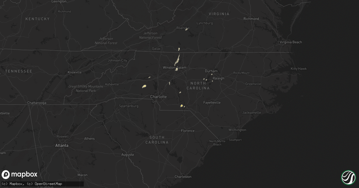
Hail Map in North Carolina on August 2, 2018
Get this storm
August 2 map
$229
one time, instant access
Download today. No call, no setup
Keep the $229
Bought the map and want the full workflow? Apply the entire $229 to a subscription within 7 days. None of it is wasted.
Every map, not just this one
This buys you this map. Subscription and you get every map we run, in the markets you choose from a few cities to whole states to nationwide. Plus real-time alerts the moment a storm fires.
Contact data
Name, contact info, occupancy, even credit band for addresses in the footprint. You go from where it hit to who to call.
Become the source they trust
Unlimited branding weather history reports on demand. You already have the documented answer ready for the property owner, and you are the one who showed up with it.
Property data and RoofTrace estimates
Pull up any address you have got, its value and the exact code rules for that jurisdiction, straight from One Click Code. Then RoofTrace estimates the squares, pitch, and roof value, priced the way you price.
Storm reports in North Carolina
North Carolina
| Date | Description |
|---|---|
| 08/02/20186:10 PM CDT | Tree down on us route 21 near old highway 21 near elkin. Time estimated from radar. |
| 08/02/20186:06 PM CDT | Wilkes county dispatch reported trees down in pleasant hill. |
| 08/02/20185:23 PM CDT | Corrects previous tstm wnd dmg report from 2 wnw pfafftown. Shattalon dr and gracemont dr closed due to downed tree on powerlines. Powerlines snapped with knocking tran |
| 08/02/20183:30 PM CDT | A large tree and multiple large limbs were blown down near the community of pine hall by thunderstorm winds. |
| 08/02/20183:30 PM CDT | 3-4 trees down at darrow rd and reidsville rd. |
| 08/02/20183:30 PM CDT | Power lines down on walnut cove rd. |
| 08/02/20183:20 PM CDT | A few trees were blown down around the community of walnut cove. |
| 08/02/20183:10 PM CDT | Numerous trees and power lines down throughout the lewisville area. |
| 08/02/20183:00 PM CDT | Corrects previous tstm wnd dmg report from lewisville. Several trees down in the area. |
| 08/02/20182:59 PM CDT | 1 tree down on nc-109 outside of wadesboro. Time estimated from radar. |
| 08/02/20182:55 PM CDT | Several trees down in the area. |
| 08/02/20182:38 PM CDT | Tree down at s roxboro and vistawood. |
| 08/02/20182:35 PM CDT | Tree down on powerline near bynum rd and hearne rd. Time estimated from radar. |
| 08/02/20182:34 PM CDT | Tree down on powerlines along sugar lake rd. Time estimated from radar. |
| 08/02/20182:34 PM CDT | Tree down on nc-902 and meronies church rd. |
| 08/02/20182:20 PM CDT | Tree down on nc-22 and nc-42. Time estimated from radar. |
| 08/02/20182:18 PM CDT | Tree down. |
| 08/02/20182:12 PM CDT | Three trees down on olive chapel rd... Including one on a car. |
| 08/02/20182:05 PM CDT | Tree down on garrett rd. Time estimated from radar. |
| 08/02/20181:48 PM CDT | 2 trees down in carthage. |
| 08/02/20181:39 PM CDT | Tree down on collins mountain rd at orange county line. |
| 08/02/20181:08 PM CDT | Tree down on burnett rd and norris rd. Time estimated from radar. |
| 08/02/20181:02 PM CDT | Tree down at sherrill baggett rd and dunn rd. |
| 08/02/201812:04 PM CDT | A local report indicates 60 MPH wind near LUMBERTON |
| 08/02/20181:24 AM CDT | At 620 PM EDT, several thunderstorms extended from near Taylorsville through Mocksville to near Winston-Salem. These storms are moving north at 25 mph. The storms are expected to merge and reach severe levels during the next hour. HAZARD...60 mph wind gusts. SOURCE...Radar indicated. IMPACT...Expect damage to roofs, siding, and trees. Locations impacted include... North Wilkesboro... Elkin... Wilkesboro... Fairview... and Yadkinville. |
| 08/02/20181:14 AM CDT | At 611 PM EDT, a line of severe thunderstorms were located from Arcadia to near PTI Airport, moving north at 20 mph. These storms will move across the Winston-Salem area again. Saturated ground will contribute to the wind gusts in downing trees. HAZARD...60 mph wind gusts. SOURCE...Radar indicated. IMPACT...Expect damage to trees. Locations impacted include... Winston-Salem, High Point, Kernersville, Clemmons, Bermuda Run, Huntsville, Lewisville, Summerfield and Stokesdale. |
| 08/02/201812:26 AM CDT | At 525 PM EDT, severe thunderstorms were located along a line extending from near Penhook to Price, moving northeast at 30 mph. HAZARD...60 mph wind gusts. SOURCE...Radar indicated. IMPACT...Expect damage to roofs, siding, and trees. Locations impacted include... Martinsville... Callands... Axton... Penhook... and Snow Creek.This includes The following Locations The Martinsville Speedway andMartinsville Airport. |
| 08/01/201811:51 PM CDT | At 450 PM EDT, severe thunderstorms were located along a line extending from near Ayersville to near Ellisboro, moving northeast at 20 mph. HAZARD...60 mph wind gusts. SOURCE...Radar indicated. IMPACT...Expect damage to roofs, siding, and trees. Locations impacted include... Eden... Wentworth... Stoneville... and Price. |
| 08/01/201811:33 PM CDT | At 433 PM EDT, a severe thunderstorm was located near Oxford, moving northeast at 35 mph. HAZARD...60 mph wind gusts. SOURCE...Radar indicated. IMPACT...Expect damage to roofs, siding, and trees. Locations impacted include... Stovall, Dabney, Tungsten, Satterwhite Point Marina, John H Kerr Reservoir, Steele Creek Marina & Campground, Bullocksville and Kerr Lake. |
| 08/01/201811:18 PM CDT | At 418 PM EDT, severe thunderstorms were located along a line extending from near Germanton to near Kernersville, moving northeast at 15 mph. HAZARD...60 mph wind gusts. SOURCE...Radar indicated. IMPACT...Expect damage to roofs, siding, and trees. Locations impacted include... Mayodan... Madison... Walnut Cove... Stoneville... and Danbury. |
| 08/01/201811:08 PM CDT | At 407 PM EDT, a severe thunderstorm was located near Creedmoor, moving northeast at 30 mph. HAZARD...60 mph wind gusts. SOURCE...Radar indicated. IMPACT...Expect damage to roofs, siding, and trees. Locations impacted include... Henderson, Oxford, Creedmoor, Franklinton, Kittrell, Stem, Dabney, Ingleside, Gillburg and South Henderson. |
| 08/01/201810:56 PM CDT | At 354 PM EDT, a severe thunderstorm was located near Enon, or 7 miles west of Winston-Salem, moving east at 50 mph. HAZARD...60 mph wind gusts. SOURCE...Radar indicated. IMPACT...Expect damage to trees. Wet soils and strong winds may down numerous trees. Locations impacted include... Winston-Salem, Kernersville, Clemmons, Bermuda Run, Lewisville, Walkertown, Rural Hall, Pfafftown, Belews Creek and Stanleyville. |
| 08/01/201810:46 PM CDT | At 346 PM EDT, a severe thunderstorm was located near Wadesboro, moving east at 15 mph. HAZARD...60 mph wind gusts and penny size hail. SOURCE...Radar indicated. IMPACT...Expect damage to roofs, siding, and trees. Locations impacted include... Rockingham, Wadesboro, Hamlet, Ellerbe, Dobbins Heights, Lilesville, Morven, Norman, East Rockingham and Blewett Falls Lake. |
| 08/01/201810:39 PM CDT | At 339 PM EDT, a severe thunderstorm was located near Durham, moving northeast at 15 mph. HAZARD...60 mph wind gusts. SOURCE...Radar indicated. IMPACT...Expect damage to roofs, siding, and trees. Locations impacted include... Raleigh, Durham, Creedmoor, Butner, Stem, Falls Lake State Rec Area, Gorman, Falls Lake, Lake Butner and Falls Lake Boat Ramp. |
| 08/01/201810:39 PM CDT | Tree limbs down. Several windows broken and blown out by straight-line wind at the old troy hotel. |
| 08/01/201810:32 PM CDT | At 331 PM EDT, a severe thunderstorm was located near Pittsboro, moving northeast at 30 mph. HAZARD...60 mph wind gusts. SOURCE...Radar indicated. IMPACT...Expect damage to roofs, siding, and trees. Locations impacted include... Raleigh, Durham, Cary, Pittsboro, Apex, Holly Springs, Morrisville, Crosswinds Boating Center, Crosswinds Campground and New Hill. |
| 08/01/201810:11 PM CDT | At 311 PM EDT, a severe thunderstorm was located near Cary, moving north at 30 mph. HAZARD...60 mph wind gusts. SOURCE...Radar indicated. IMPACT...Expect damage to roofs, siding, and trees. Locations impacted include... Raleigh, Durham, Cary, Rdu International, Apex, Holly Springs, Morrisville, Lake Wheeler, New Hill and Parkwood. |
| 08/01/20189:58 PM CDT | At 257 PM EDT, a severe thunderstorm was located 7 miles south of Carrboro, or 7 miles northeast of Pittsboro, moving northeast at 20 mph. HAZARD...60 mph wind gusts. SOURCE...Radar indicated. IMPACT...Expect damage to roofs, siding, and trees. Locations impacted include... Durham, Cary, Chapel Hill, Carrboro, Morrisville, Crosswinds Boating Center, Crosswinds Campground, Parkwood, Research Triangle and Jordan Lake State Rec Area. |
| 08/01/20189:46 PM CDT | At 245 PM EDT, a severe thunderstorm was located near Benson, or 11 miles east of Lillington, moving north at 15 mph. HAZARD...60 mph wind gusts. SOURCE...Radar indicated. IMPACT...Expect damage to roofs, siding, and trees. Locations impacted include... Coats Crossroads. |
| 08/01/20189:34 PM CDT | At 233 PM EDT, a severe thunderstorm was located near Pittsboro, moving northeast at 20 mph. HAZARD...60 mph wind gusts. SOURCE...Radar indicated. IMPACT...Expect damage to roofs, siding, and trees. Locations impacted include... Durham, Chapel Hill, Pittsboro, Carrboro, Bynum, Fearrington, Lake Jordan and Cane Creek Reservoir. |
| 08/01/20189:26 PM CDT | At 225 PM EDT, a severe thunderstorm was located over Dunn, or 10 miles southeast of Lillington, moving north at 25 mph. HAZARD...60 mph wind gusts. SOURCE...Radar indicated. IMPACT...Expect damage to roofs, siding, and trees. Locations impacted include... Lillington, Dunn, Angier, Benson, Erwin, Coats, Four Oaks, Spivey's Corner, Coats Crossroads and Buies Creek. |
| 08/01/20188:58 PM CDT | At 158 PM EDT, a severe thunderstorm was located 9 miles south of Godwin, or 11 miles east of Fayetteville, moving north at 35 mph. HAZARD...60 mph wind gusts. SOURCE...Radar indicated. IMPACT...Expect damage to roofs, siding, and trees. Locations impacted include... Dunn, Benson, Godwin, Erwin, Eastover, Wade, Falcon, Linden, Spivey's Corner and Vander. |
| 08/01/20188:33 PM CDT | At 132 PM EDT, a severe thunderstorm was located over Tobermory, or 16 miles northeast of Lumberton, moving north at 35 mph. HAZARD...60 mph wind gusts. SOURCE...Radar indicated. IMPACT...Expect damage to roofs, siding, and trees. Locations impacted include... Fayetteville, Hope Mills, Eastover, Stedman, Wade, Autryville, Vander, Cedar Creek and Bushy Lake Natural Area. |
| 08/01/20188:11 PM CDT | At 111 PM EDT, a severe thunderstorm was located over Hestertown, or near Lumberton, moving north at 35 mph. HAZARD...60 mph wind gusts. SOURCE...Radar indicated. IMPACT...Minor hail damage to vehicles is possible. Expect wind damage to trees and power lines. Locations impacted include... Lumberton, Fairmont, St. Pauls, Smiths, Rex, Howellsville, Tolarsville, Duart, Hestertown, Buie, Robeson Community College, Tobermory, Barker Ten Mile, Jerome, Shannon, Parkton, Rennert, Proctorville, Tar Heel and Lumber Bridge.This includes the following highways... Interstate 74 between mile markers 212 and 207, and between milemarkers 209 and 210, and near mile marker 214. Interstate 95 IN North Carolina between mile markers 10 and 38. US Route 74 between mile markers 365 and 372. |
All States Impacted by Hail Map on August 2, 2018
Cities Impacted by Hail Map on August 2, 2018
- Danville, IL
- Bismarck, IL
- Citra, FL
- Ocala, FL
- Anthony, FL
- Saint Anne, IL
- Martinton, IL
- Clifton, IL
- Kingman, AZ
- Pittsboro, NC
- Donovan, IL
- Pembroke Township, IL
- Kentland, IN
- Morocco, IN
- Brook, IN
- Beaverville, IL
- Goodland, IN
- Belcourt, ND
- Midland, MI
- Pinconning, MI
- Linwood, MI
- Ribera, NM
- Mora, NM
- Lake Village, IN
- O'Fallon, MO
- Brussels, IL
- Golden Eagle, IL
- Bapchule, AZ
- Meadview, AZ
- Lincolnton, NC
- Vale, NC
- Fowler, IN
- Sandy Ridge, NC
- Rensselaer, IN
- Wolcott, IN
- Remington, IN
- Monon, IN
- Erath, LA
- Chillicothe, MO
- Jamesport, MO
- Earl Park, IN
- Hebron, IN
- Pewamo, MI
- Prescott, AZ
- Brookston, IN
- Chalmers, IN
- Galien, MI
- Buchanan, MI
- Berrien Springs, MI
- East Carondelet, IL
- Columbia, IL
- East Saint Louis, IL
- Saint Louis, MO
- Dupo, IL
- Otterbein, IN
- Oxford, IN
- West Lafayette, IN
- Saint Peters, MO
- Winfield, MO
- Saint Charles, MO
- Old Monroe, MO
- New Buffalo, MI
- Walnut Cove, NC
- Ambia, IN
- Hoopeston, IL
- Plainwell, MI
- Maricopa, AZ
- Absarokee, MT
- Hubbardston, MI
- Muir, MI
- Baroda, MI
- Saint Joseph, MI
- Sawyer, MI
- Bridgman, MI
- Stevensville, MI
- Eau Claire, MI
- Sodus, MI
- Lowell, IN
- Shelby, IN
- Demotte, IN
- Bristol, IN
- Browning, IL
- Astoria, IL
- Weidman, MI
- Mount Pleasant, MI
- Remus, MI
- Surprise, AZ
- Tucson, AZ
- Port Hope, MI
- Kirkland, AZ
- Niles, MI
- Watseka, IL
- Potomac, IL
- Rossville, IL
- Boswell, IN
- Sheldon, IL
- Armstrong, IL
- Winston Salem, NC
- Bay City, MI
- Humphreys, MO
- Galt, MO
- Patrick Springs, VA
- Delcambre, LA
- Frankenmuth, MI
- Saginaw, MI
- Reese, MI
- Claremont, NC
- Conover, NC
- Boone Grove, IN
- Kouts, IN
- Thayer, IN
- Valparaiso, IN
- Allegan, MI
- Pullman, MI
- Grand Junction, MI
- Greenville, MI
- Germanton, NC
- Madison, NC
- Lilesville, NC
- Wadesboro, NC
- Bay Port, MI
- New Iberia, LA
- Sells, AZ
- Wittmann, AZ
- Leeds, UT
- Edwardsburg, MI
- Granger, IN
- Peoria, AZ
- Eloy, AZ
- Yucca, AZ
- Troy, NC
- Buckeye, AZ
- Mount Sidney, VA
- Weyers Cave, VA
- Crescent City, IL
- Las Vegas, NM
- Goodyear, AZ
- Rolling Prairie, IN
- Wagon Mound, NM
- Kawkawlin, MI
- Auburn, MI
- Gobles, MI
- Cassopolis, MI
- Dowagiac, MI
- Caseville, MI
- Screven, GA
- Shelbyville, IL
- Saint Albans, MO
- Jacksonville, FL
- Chesterfield, MO
- Defiance, MO
- Durham, NC
- Morrisville, NC
- Findlay, IL
- Hanna, IN
- Perth, ND
- Saint John, ND
- Casa Grande, AZ
- Hamlet, IN
- Lyons, MI
- Fowler, MI
- Ionia, MI
- Pana, IL
- Tower Hill, IL
- Vinton, VA
- Goodview, VA
- Hardy, VA
- Saint Johns, MI
- Myakka City, FL
- Rocklake, ND
- Rolla, ND
- Salisbury, NC
- Newton, NC
- Cherryville, NC
- Coleman, MI
- Rhodes, MI
- Lake City, MI
- Harbert, MI
- Three Oaks, MI
- Berrien Center, MI
- Union Pier, MI
- Lakeside, MI
- Stuart, VA
- Spencer, VA
- Critz, VA
- Bassett, VA
- Searchlight, NV
- Seligman, AZ
- Fort Defiance, VA
- Mount Crawford, VA
- Staunton, VA
- Verona, VA
- Salome, AZ
- Register, GA
- Metter, GA
- Statesboro, GA
- Delton, MI
- Hastings, MI
- New Douglas, IL
- Firth, ID
- Holly Springs, NC
- Apex, NC
- Chebanse, IL
- Gays, IL
- Reynolds, IN
- Schneider, IN
- Wheatfield, IN
- Momence, IL
- Iroquois, IL
- Lawrence, MI
- Hartford, MI
- Otsego, MI
- Lake Panasoffkee, FL
- Dunseith, ND
- Elkhart, IN


