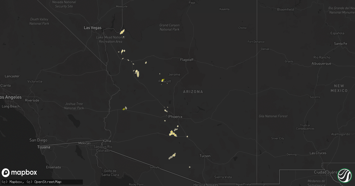
Hail Map in Arizona on August 2, 2018
Get this storm
August 2 map
$229
one time, instant access
Download today. No call, no setup
Keep the $229
Bought the map and want the full workflow? Apply the entire $229 to a subscription within 7 days. None of it is wasted.
Every map, not just this one
This buys you this map. Subscription and you get every map we run, in the markets you choose from a few cities to whole states to nationwide. Plus real-time alerts the moment a storm fires.
Contact data
Name, contact info, occupancy, even credit band for addresses in the footprint. You go from where it hit to who to call.
Become the source they trust
Unlimited branding weather history reports on demand. You already have the documented answer ready for the property owner, and you are the one who showed up with it.
Property data and RoofTrace estimates
Pull up any address you have got, its value and the exact code rules for that jurisdiction, straight from One Click Code. Then RoofTrace estimates the squares, pitch, and roof value, priced the way you price.
Storm reports in Arizona
Arizona
| Date | Description |
|---|---|
| 08/02/20181:45 PM CDT | Quarter-sized hail was reported by the public as a strong thunderstorm moved over the prescott area. |
| 08/02/20187:41 AM CDT | At 1238 PM PDT/1238 PM MST/, a severe thunderstorm was located near Railroad Pass, or 9 miles southwest of Boulder City, moving northeast at 15 mph. HAZARD...50 to 60 mph wind gusts. SOURCE...Radar indicated. IMPACT...Expect damage to roofs and trees. Locations impacted include... Henderson, Boulder City, Las Vegas Bay, Lake Las Vegas, Boulder Beach, Callville Bay Campground, Railroad Pass, Boulder Beach Campground, Las Vegas Bay Campground, Callville Bay, Hoover Dam and Black Mtn. |
| 08/02/20187:30 AM CDT | At 1230 PM MST, a severe thunderstorm was located near Brenda, or 36 miles southeast of Parker, moving northeast at 5 mph. HAZARD...60 mph wind gusts and half dollar size hail. SOURCE...Radar indicated. IMPACT...Hail damage to vehicles is expected. Expect wind damage to roofs, siding, and trees. Locations impacted include... Brenda. |
| 08/02/20186:46 AM CDT | At 1145 AM MST, a severe thunderstorm was located over Blake Ranch Road, or 14 miles east of Kingman, moving east at 10 mph. HAZARD...60 mph wind gusts. SOURCE...Radar indicated. IMPACT...Expect damage to roofs and trees. Locations impacted include... Dw Ranch Road, Wild Cow Campground, Blake Ranch Road and Hualapai Mountain Park.This includes Interstate 40 in Arizona between mile markers 61 and84. |
| 08/02/20183:05 AM CDT | At 805 PM MST, a severe thunderstorm was located near Estrella Mountain Ranch, or 10 miles south of Goodyear, moving northeast at 20 mph. HAZARD...60 mph wind gusts and penny size hail. SOURCE...Radar indicated. IMPACT...Expect damage to roofs, siding, and trees. Locations impacted include... Avondale, Goodyear, Estrella Mountain Park, Estrella Mountain Ranch and Rainbow Valley. |
| 08/02/20182:49 AM CDT | At 749 PM MST, a severe thunderstorm was located near Lake Pleasant, or 8 miles southwest of New River, moving northeast at 15 mph. HAZARD...60 mph wind gusts and nickel size hail. SOURCE...Radar indicated. IMPACT...Expect damage to roofs, siding, and trees. Locations impacted include... Phoenix, Glendale, Peoria, New River, Cave Creek, Lake Pleasant and Anthem. |
| 08/02/20182:40 AM CDT | At 740 PM MST, a severe thunderstorm was located over Camelback Ranch, or over Youngtown, moving southeast at 15 mph. HAZARD...60 mph wind gusts and penny size hail. SOURCE...Radar indicated. IMPACT...Expect damage to roofs, siding, and trees. Locations impacted include... Phoenix, Glendale, Avondale, Goodyear, El Mirage, Tolleson, Youngtown, Waddell, Cashion, Sun City, Litchfield Park, Glendale Sports Complex, Luke AFB, Downtown Peoria and Downtown Glendale. |
| 08/02/20182:23 AM CDT | At 723 PM MST, a severe thunderstorm was located near Beardsley, or near Sun City West, moving east at 20 mph. HAZARD...60 mph wind gusts and quarter size hail. SOURCE...Radar indicated. IMPACT...Hail damage to vehicles is expected. Expect wind damage to roofs, siding, and trees. Locations impacted include... Glendale, Peoria, Surprise, El Mirage, Youngtown, Sun City West, Sun City, Waddell, Surprise Stadium, Arrowhead Mall, Beardsley and Vistancia. |
| 08/02/20181:50 AM CDT | At 650 PM MST, a severe thunderstorm was located near Beardsley, or near Sun City West, and is nearly stationary. HAZARD...60 mph wind gusts and quarter size hail. SOURCE...Radar indicated. IMPACT...Hail damage to vehicles is expected. Expect wind damage to roofs, siding, and trees. Locations impacted include... Glendale, Surprise, El Mirage, Youngtown, Sun City West, Sun City, Waddell, Surprise Stadium, Arrowhead Mall, Beardsley and Vistancia. |
| 08/02/20181:42 AM CDT | At 642 PM MST, severe thunderstorms were located along a line extending from near Painted Rock Dam to 9 miles southeast of Estrella Mountain Park, moving northeast at 15 mph. HAZARD...60 mph wind gusts and penny size hail. SOURCE...Radar indicated. IMPACT...Expect damage to roofs, siding, and trees. Locations impacted include... Avondale, Goodyear, Buckeye, Palo Verde, Perryville, Liberty, Phoenix International Raceway, Estrella Mountain Park, Estrella Mountain Ranch, Hassayampa, Rainbow Valley, Komatke and Arlington. |
| 08/02/20181:32 AM CDT | At 632 PM MST, a severe thunderstorm was located near Sun Lakes, moving north at 15 mph. HAZARD...60 mph wind gusts and penny size hail. SOURCE...Radar indicated. IMPACT...Expect damage to roofs, siding, and trees. Locations impacted include... Chandler, Gilbert, Tempe, Sun Lakes, Bapchule, Tumbleweed Park, Chandler Fashion Center Mall, Chandler City Hall, Firebird Lake and Santan. |
| 08/02/20181:12 AM CDT | At 612 PM MST, severe thunderstorms were located along a line extending from near Liberty to 6 miles northwest of Estrella Sailport, moving northeast at 10 mph. HAZARD...60 mph wind gusts and penny size hail. SOURCE...Radar indicated. IMPACT...Expect damage to roofs, siding, and trees. Locations impacted include... Avondale, Goodyear, Perryville, Liberty, Estrella Mountain Park, Estrella Mountain Ranch and Rainbow Valley. |
| 08/02/201812:57 AM CDT | At 556 PM MST, a severe thunderstorm was located near Arizola, or near Casa Grande, moving northeast at 10 mph. HAZARD...60 mph wind gusts and penny size hail. SOURCE...Radar indicated. IMPACT...Expect damage to roofs, siding, and trees. Locations impacted include... Casa Grande, La Palma, Arizola, Randolph and Toltec. |
| 08/02/201812:43 AM CDT | At 543 PM MST, severe thunderstorms were located along a line extending from near Estrella Sailport to 14 miles west of Casa Grande, moving east at 5 mph. HAZARD...60 mph wind gusts and penny size hail. SOURCE...Radar indicated. IMPACT...Expect damage to roofs, siding, and trees. Locations impacted include... Maricopa, Estrella Sailport, Stanfield, Mobile and Ak- Chin Village. |
| 08/02/201812:19 AM CDT | At 518 PM MST, a severe thunderstorm was located near Freeman, or 24 miles east of Gila Bend, moving northeast at 15 mph. HAZARD...60 mph wind gusts and penny size hail. SOURCE...Radar indicated. IMPACT...Expect damage to roofs, siding, and trees. Locations impacted include... Estrella Sailport, Freeman, Ak-Chin Village and Stanfield. |
| 08/01/201811:38 PM CDT | At 435 PM MST, a severe thunderstorm was located just east of Covered Wells near Highway 86, or 25 miles northwest of Sells, moving northwest at 5 to 10 mph. HAZARD...60 mph wind gusts and quarter size hail. SOURCE...Radar indicated. IMPACT...Hail damage to vehicles is expected. Expect wind damage to roofs, siding, and trees. Locations impacted include... Mountain Village, San Simon Village and Covered Wells. This includes Route 86 between mile markers 70 and 96. |
| 08/01/201811:18 PM CDT | At 417 PM MST, a severe thunderstorm was located near Wilhoit, or 14 miles southwest of Prescott Valley, moving northeast at 5 mph. HAZARD...60 mph wind gusts and quarter size hail. SOURCE...Radar indicated. IMPACT...Hail damage to vehicles is expected. Expect wind damage to roofs, siding, and trees. Locations impacted include... Walker, Ponderosa Park, Groom Creek Subdivision, Lower Wolf Creek Campground and Upper Wolf Creek Group Campground. |
| 08/01/201811:12 PM CDT | At 412 PM MST, a severe thunderstorm was located 13 miles east of Santa Rosa, or 26 miles north of Sells, and is nearly stationary. HAZARD...70 mph wind gusts and ping pong ball size hail. SOURCE...Radar indicated. IMPACT...People and animals outdoors will be injured. Expect hail damage to roofs, siding, windows, and vehicles. Expect considerable tree damage. Wind damage is also likely to mobile homes, roofs, and outbuildings. Locations impacted include... Santa Rosa, Sil Naggia and Ak Chin. |
| 08/01/201810:59 PM CDT | At 358 PM MST, a severe thunderstorm was located 16 miles northeast of Wikieup, moving northwest at 15 mph. HAZARD...60 mph wind gusts. SOURCE...Radar indicated. IMPACT...Expect damage to roofs and trees. This severe thunderstorm will impact travelers along Highway 93 between Wikieup and Interstate 40. |
| 08/01/20189:53 PM CDT | Spotter reports that wind snapped a branch with a 5 inch diameter off of a tree in his yard.... |
| 08/01/20189:30 PM CDT | Spotter reported trees down in the area and some street flooding. |
| 08/01/20189:26 PM CDT | At 225 PM PDT/225 PM MST/, a severe thunderstorm was located 12 miles southeast of Boulder City, moving northeast at 10 mph. HAZARD...60 mph wind gusts. SOURCE...Radar indicated. IMPACT...Expect damage to roofs and trees. Locations impacted include... Boulder City, Hoover Dam, Lake Mead National Recreation Area and Willow Beach. |
| 08/01/20189:14 PM CDT | Overturned semi in i-10 at milepost 110. |
| 08/01/20188:55 PM CDT | [corrected lsr] corrects timing of previous hail report from 4 wnw waddell. Spotter reported hail of over 1 inch in diameter. |
| 08/01/20188:52 PM CDT | Power pole |
| 08/01/20188:48 PM CDT | Trees down and window cracked in home. |
| 08/01/20188:48 PM CDT | Trees down. |
| 08/01/20188:47 PM CDT | Spotter reporting hail of over 1 inch in diameter. |
| 08/01/20188:45 PM CDT | Trees down. |
| 08/01/20188:45 PM CDT | Minor to moderate roof damage to many houses in the subdivision. |
| 08/01/20188:39 PM CDT | At 139 PM MST, a severe thunderstorm was located over Yavapai Campground, or 8 miles west of Prescott Valley, moving northeast at 15 mph. HAZARD...60 mph wind gusts and quarter size hail. SOURCE...Radar indicated. IMPACT...Hail damage to vehicles is expected. Expect wind damage to roofs, siding, and trees. Locations impacted include... Chino Valley, Prescott Valley, Prescott, Prescott Airport, Williamson Valley, Prescott Gateway Mall, Iron Springs, Yavapai Campground, Downtown Prescott, Ponderosa Park, Indian Hill West Prescott, Oak Knoll Village, Wilhoit, Lynx Lake Dam, Prescott Valley Event Center and White Spar Campground.This includes the following highways... State Route 89 between mile markers 300 and 326. State Route 89A between mile markers 318 and 321. State Route 69 between mile markers 287 and 296. |
| 08/01/20188:37 PM CDT | At 137 PM MST, a severe thunderstorm was located near South Cove, or 39 miles southeast of Overton, moving northeast at 15 mph. HAZARD...60 mph wind gusts. SOURCE...Radar indicated. IMPACT...Expect damage to roofs and trees. Locations impacted include... Grand Canyon Skywalk, South Cove, Meadview and Lake Mead National Recreation Area. |
| 08/01/20188:35 PM CDT | Roof destroyed. Privacy wall down. |
| 08/01/20188:30 PM CDT | **delayed report** city of goodyear reported several large power lines/poles downed due to storm winds. Time estimated. |
| 08/01/20188:30 PM CDT | Home in estrella mountain ranch subdivision lost a couple trees... Several roof tiles and suffered a damaged garage door. |
| 08/01/20188:20 PM CDT | Chandler airport awos gust 61 mph and 1/4 mile visibility in blowing dust. |
| 08/01/20188:15 PM CDT | **delayed report** news reported that buckeye valley fd stated 10-15 homes in the area suffered heavy damage from strong winds. Time estimated. |
| 08/01/20188:15 PM CDT | *** 2 inj *** corrects previous tstm wnd dmg report from 6 ne arizona city. **delayed report** 2 mobile homes demolished. 2 mobile homes with roof damage. 4 mobile home |
| 08/01/20188:08 PM CDT | Homes reported destroyed with major roof damage. High tension power line down. 190th ave and arlington. Per fire dept. |
| 08/01/20188:00 PM CDT | At 100 PM MST, a severe thunderstorm was located over Brenda, or 37 miles southeast of Parker, moving north at 10 mph. HAZARD...60 mph wind gusts and half dollar size hail. SOURCE...Radar indicated. IMPACT...Hail damage to vehicles is expected. Expect wind damage to roofs, siding, and trees. Locations impacted include... Brenda. |
All States Impacted by Hail Map on August 2, 2018
Cities Impacted by Hail Map on August 2, 2018
- Danville, IL
- Bismarck, IL
- Citra, FL
- Ocala, FL
- Anthony, FL
- Saint Anne, IL
- Martinton, IL
- Clifton, IL
- Kingman, AZ
- Pittsboro, NC
- Donovan, IL
- Pembroke Township, IL
- Kentland, IN
- Morocco, IN
- Brook, IN
- Beaverville, IL
- Goodland, IN
- Belcourt, ND
- Midland, MI
- Pinconning, MI
- Linwood, MI
- Ribera, NM
- Mora, NM
- Lake Village, IN
- O'Fallon, MO
- Brussels, IL
- Golden Eagle, IL
- Bapchule, AZ
- Meadview, AZ
- Lincolnton, NC
- Vale, NC
- Fowler, IN
- Sandy Ridge, NC
- Rensselaer, IN
- Wolcott, IN
- Remington, IN
- Monon, IN
- Erath, LA
- Chillicothe, MO
- Jamesport, MO
- Earl Park, IN
- Hebron, IN
- Pewamo, MI
- Prescott, AZ
- Brookston, IN
- Chalmers, IN
- Galien, MI
- Buchanan, MI
- Berrien Springs, MI
- East Carondelet, IL
- Columbia, IL
- East Saint Louis, IL
- Saint Louis, MO
- Dupo, IL
- Otterbein, IN
- Oxford, IN
- West Lafayette, IN
- Saint Peters, MO
- Winfield, MO
- Saint Charles, MO
- Old Monroe, MO
- New Buffalo, MI
- Walnut Cove, NC
- Ambia, IN
- Hoopeston, IL
- Plainwell, MI
- Maricopa, AZ
- Absarokee, MT
- Hubbardston, MI
- Muir, MI
- Baroda, MI
- Saint Joseph, MI
- Sawyer, MI
- Bridgman, MI
- Stevensville, MI
- Eau Claire, MI
- Sodus, MI
- Lowell, IN
- Shelby, IN
- Demotte, IN
- Bristol, IN
- Browning, IL
- Astoria, IL
- Weidman, MI
- Mount Pleasant, MI
- Remus, MI
- Surprise, AZ
- Tucson, AZ
- Port Hope, MI
- Kirkland, AZ
- Niles, MI
- Watseka, IL
- Potomac, IL
- Rossville, IL
- Boswell, IN
- Sheldon, IL
- Armstrong, IL
- Winston Salem, NC
- Bay City, MI
- Humphreys, MO
- Galt, MO
- Patrick Springs, VA
- Delcambre, LA
- Frankenmuth, MI
- Saginaw, MI
- Reese, MI
- Claremont, NC
- Conover, NC
- Boone Grove, IN
- Kouts, IN
- Thayer, IN
- Valparaiso, IN
- Allegan, MI
- Pullman, MI
- Grand Junction, MI
- Greenville, MI
- Germanton, NC
- Madison, NC
- Lilesville, NC
- Wadesboro, NC
- Bay Port, MI
- New Iberia, LA
- Sells, AZ
- Wittmann, AZ
- Leeds, UT
- Edwardsburg, MI
- Granger, IN
- Peoria, AZ
- Eloy, AZ
- Yucca, AZ
- Troy, NC
- Buckeye, AZ
- Mount Sidney, VA
- Weyers Cave, VA
- Crescent City, IL
- Las Vegas, NM
- Goodyear, AZ
- Rolling Prairie, IN
- Wagon Mound, NM
- Kawkawlin, MI
- Auburn, MI
- Gobles, MI
- Cassopolis, MI
- Dowagiac, MI
- Caseville, MI
- Screven, GA
- Shelbyville, IL
- Saint Albans, MO
- Jacksonville, FL
- Chesterfield, MO
- Defiance, MO
- Durham, NC
- Morrisville, NC
- Findlay, IL
- Hanna, IN
- Perth, ND
- Saint John, ND
- Casa Grande, AZ
- Hamlet, IN
- Lyons, MI
- Fowler, MI
- Ionia, MI
- Pana, IL
- Tower Hill, IL
- Vinton, VA
- Goodview, VA
- Hardy, VA
- Saint Johns, MI
- Myakka City, FL
- Rocklake, ND
- Rolla, ND
- Salisbury, NC
- Newton, NC
- Cherryville, NC
- Coleman, MI
- Rhodes, MI
- Lake City, MI
- Harbert, MI
- Three Oaks, MI
- Berrien Center, MI
- Union Pier, MI
- Lakeside, MI
- Stuart, VA
- Spencer, VA
- Critz, VA
- Bassett, VA
- Searchlight, NV
- Seligman, AZ
- Fort Defiance, VA
- Mount Crawford, VA
- Staunton, VA
- Verona, VA
- Salome, AZ
- Register, GA
- Metter, GA
- Statesboro, GA
- Delton, MI
- Hastings, MI
- New Douglas, IL
- Firth, ID
- Holly Springs, NC
- Apex, NC
- Chebanse, IL
- Gays, IL
- Reynolds, IN
- Schneider, IN
- Wheatfield, IN
- Momence, IL
- Iroquois, IL
- Lawrence, MI
- Hartford, MI
- Otsego, MI
- Lake Panasoffkee, FL
- Dunseith, ND
- Elkhart, IN


