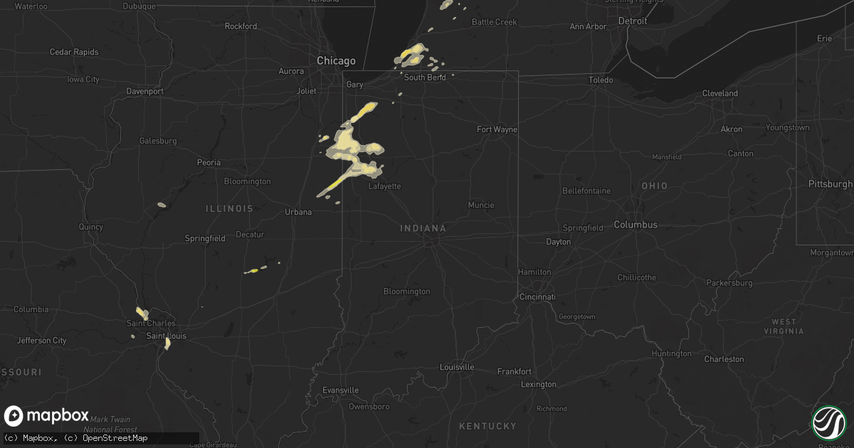
Hail Map in Indiana on August 2, 2018
Get this storm
August 2 map
$229
one time, instant access
Download today. No call, no setup
Keep the $229
Bought the map and want the full workflow? Apply the entire $229 to a subscription within 7 days. None of it is wasted.
Every map, not just this one
This buys you this map. Subscription and you get every map we run, in the markets you choose from a few cities to whole states to nationwide. Plus real-time alerts the moment a storm fires.
Contact data
Name, contact info, occupancy, even credit band for addresses in the footprint. You go from where it hit to who to call.
Become the source they trust
Unlimited branding weather history reports on demand. You already have the documented answer ready for the property owner, and you are the one who showed up with it.
Property data and RoofTrace estimates
Pull up any address you have got, its value and the exact code rules for that jurisdiction, straight from One Click Code. Then RoofTrace estimates the squares, pitch, and roof value, priced the way you price.
Storm reports in Indiana
Indiana
| Date | Description |
|---|---|
| 08/02/20184:44 PM CDT | Numerous large trees down... Many uprooted... One tree into a garage. Damage in the area was described as significant and widespread. |
| 08/02/20182:45 AM CDT | At 744 PM EDT/644 PM CDT/, a severe thunderstorm was located near Monon, or 8 miles southeast of McCoysburg, moving east at 15 mph. Doppler radar also indicated weak rotation with this storm. HAZARD...60 mph wind gusts and quarter size hail. SOURCE...Radar indicated. IMPACT...Hail damage to vehicles is expected. Expect wind damage to roofs, siding, and trees. Locations impacted include... Monticello, Monon, Wolcott, Reynolds, Burnettsville, Lakeside In Pulaski County, Headlee, Lee, Indiana Beach, Norway, Idaville, Sitka, Bell Center and Buffalo. |
| 08/02/20182:28 AM CDT | At 727 PM CDT, a severe thunderstorm was located near Potomac, or 8 miles northwest of Danville, moving northeast at 15 mph. HAZARD...60 mph wind gusts and quarter size hail. SOURCE...Radar indicated. IMPACT...Hail damage to vehicles is expected. Expect wind damage to roofs, siding, and trees. Locations impacted include... Danville, Oakwood, Rossville, Potomac, Bismarck, Henning, Middle Fork Wildlife Area, Collison, Alvin, Vermilion County Airport and Kickapoo State Park.This includes Interstate 74 between mile markers 207 and 210. |
| 08/02/20182:21 AM CDT | At 721 PM CDT, severe thunderstorms were located along a line extending from near Goodland to Boswell, moving east at 20 mph. HAZARD...60 mph wind gusts and quarter size hail. SOURCE...Radar indicated. IMPACT...Hail damage to vehicles is expected. Expect wind damage to roofs, siding, and trees. Severe thunderstorms will be near, Wadena and Goodland around 825 PM EDT. Remington around 835 PM EDT. Barce and Oxford around 840 PM EDT. Atkinson around 845 PM EDT. Foresman around 855 PM EDT. Otterbein around 905 PM EDT. Including the following interstate... Indiana I-65 between mile markers 200 and 206. |
| 08/02/20181:58 AM CDT | At 658 PM CDT/758 PM EDT/, a severe thunderstorm was located near Hoopeston, or 8 miles southwest of Talbot, moving northeast at 25 mph. HAZARD...60 mph wind gusts and quarter size hail. SOURCE...Radar indicated. IMPACT...Hail damage to vehicles is expected. Expect wind damage to roofs, siding, and trees. Locations impacted include... Fowler, Dunnington, Talbot, Freeland Park, Oxford, Boswell and Ambia. |
| 08/02/20181:52 AM CDT | At 651 PM EDT, a severe thunderstorm was located from near Edwardsburg to just west of Cassopolis, moving northeast at 30 mph. HAZARD...60 mph wind gusts and quarter size hail. SOURCE...Radar indicated. IMPACT...Hail damage to vehicles is expected. Expect wind damage to roofs, siding, and trees. Locations impacted include... Dowagiac, Cassopolis, Edwardsburg, Marcellus, Union, Pokagon, Penn, Vandalia, Dailey, La Grange, Paradise Lake, Barron Lake, Calvin Center, Adamsville, Juno Lake, Donnell Lake, Jones, Diamond Lake, Shavehead Lake and Wakelee. |
| 08/02/201812:54 AM CDT | At 553 PM CDT/653 PM EDT/, a severe thunderstorm was located over Sheldon, or near Raub, moving east at 20 mph. HAZARD...60 mph wind gusts and quarter size hail. SOURCE...Radar indicated. IMPACT...Hail damage to vehicles is expected. Expect wind damage to roofs, siding, and trees. Locations impacted include... Kentland, Raub, Sheldon and Iroquois. |
| 08/02/201812:32 AM CDT | At 531 PM CDT, a severe thunderstorm was located near Foresman, moving east at 15 mph. HAZARD...60 mph wind gusts and quarter size hail. SOURCE...Radar indicated. IMPACT...Hail damage to vehicles is expected. Expect wind damage to roofs, siding, and trees. Locations impacted include... Rensselaer, Surrey, Brook, Collegeville and Mount Ayr. Including the following interstate... Indiana I-65 between mile markers 205 and 220. |
All States Impacted by Hail Map on August 2, 2018
Cities Impacted by Hail Map on August 2, 2018
- Danville, IL
- Bismarck, IL
- Citra, FL
- Ocala, FL
- Anthony, FL
- Saint Anne, IL
- Martinton, IL
- Clifton, IL
- Kingman, AZ
- Pittsboro, NC
- Donovan, IL
- Pembroke Township, IL
- Kentland, IN
- Morocco, IN
- Brook, IN
- Beaverville, IL
- Goodland, IN
- Belcourt, ND
- Midland, MI
- Pinconning, MI
- Linwood, MI
- Ribera, NM
- Mora, NM
- Lake Village, IN
- O'Fallon, MO
- Brussels, IL
- Golden Eagle, IL
- Bapchule, AZ
- Meadview, AZ
- Lincolnton, NC
- Vale, NC
- Fowler, IN
- Sandy Ridge, NC
- Rensselaer, IN
- Wolcott, IN
- Remington, IN
- Monon, IN
- Erath, LA
- Chillicothe, MO
- Jamesport, MO
- Earl Park, IN
- Hebron, IN
- Pewamo, MI
- Prescott, AZ
- Brookston, IN
- Chalmers, IN
- Galien, MI
- Buchanan, MI
- Berrien Springs, MI
- East Carondelet, IL
- Columbia, IL
- East Saint Louis, IL
- Saint Louis, MO
- Dupo, IL
- Otterbein, IN
- Oxford, IN
- West Lafayette, IN
- Saint Peters, MO
- Winfield, MO
- Saint Charles, MO
- Old Monroe, MO
- New Buffalo, MI
- Walnut Cove, NC
- Ambia, IN
- Hoopeston, IL
- Plainwell, MI
- Maricopa, AZ
- Absarokee, MT
- Hubbardston, MI
- Muir, MI
- Baroda, MI
- Saint Joseph, MI
- Sawyer, MI
- Bridgman, MI
- Stevensville, MI
- Eau Claire, MI
- Sodus, MI
- Lowell, IN
- Shelby, IN
- Demotte, IN
- Bristol, IN
- Browning, IL
- Astoria, IL
- Weidman, MI
- Mount Pleasant, MI
- Remus, MI
- Surprise, AZ
- Tucson, AZ
- Port Hope, MI
- Kirkland, AZ
- Niles, MI
- Watseka, IL
- Potomac, IL
- Rossville, IL
- Boswell, IN
- Sheldon, IL
- Armstrong, IL
- Winston Salem, NC
- Bay City, MI
- Humphreys, MO
- Galt, MO
- Patrick Springs, VA
- Delcambre, LA
- Frankenmuth, MI
- Saginaw, MI
- Reese, MI
- Claremont, NC
- Conover, NC
- Boone Grove, IN
- Kouts, IN
- Thayer, IN
- Valparaiso, IN
- Allegan, MI
- Pullman, MI
- Grand Junction, MI
- Greenville, MI
- Germanton, NC
- Madison, NC
- Lilesville, NC
- Wadesboro, NC
- Bay Port, MI
- New Iberia, LA
- Sells, AZ
- Wittmann, AZ
- Leeds, UT
- Edwardsburg, MI
- Granger, IN
- Peoria, AZ
- Eloy, AZ
- Yucca, AZ
- Troy, NC
- Buckeye, AZ
- Mount Sidney, VA
- Weyers Cave, VA
- Crescent City, IL
- Las Vegas, NM
- Goodyear, AZ
- Rolling Prairie, IN
- Wagon Mound, NM
- Kawkawlin, MI
- Auburn, MI
- Gobles, MI
- Cassopolis, MI
- Dowagiac, MI
- Caseville, MI
- Screven, GA
- Shelbyville, IL
- Saint Albans, MO
- Jacksonville, FL
- Chesterfield, MO
- Defiance, MO
- Durham, NC
- Morrisville, NC
- Findlay, IL
- Hanna, IN
- Perth, ND
- Saint John, ND
- Casa Grande, AZ
- Hamlet, IN
- Lyons, MI
- Fowler, MI
- Ionia, MI
- Pana, IL
- Tower Hill, IL
- Vinton, VA
- Goodview, VA
- Hardy, VA
- Saint Johns, MI
- Myakka City, FL
- Rocklake, ND
- Rolla, ND
- Salisbury, NC
- Newton, NC
- Cherryville, NC
- Coleman, MI
- Rhodes, MI
- Lake City, MI
- Harbert, MI
- Three Oaks, MI
- Berrien Center, MI
- Union Pier, MI
- Lakeside, MI
- Stuart, VA
- Spencer, VA
- Critz, VA
- Bassett, VA
- Searchlight, NV
- Seligman, AZ
- Fort Defiance, VA
- Mount Crawford, VA
- Staunton, VA
- Verona, VA
- Salome, AZ
- Register, GA
- Metter, GA
- Statesboro, GA
- Delton, MI
- Hastings, MI
- New Douglas, IL
- Firth, ID
- Holly Springs, NC
- Apex, NC
- Chebanse, IL
- Gays, IL
- Reynolds, IN
- Schneider, IN
- Wheatfield, IN
- Momence, IL
- Iroquois, IL
- Lawrence, MI
- Hartford, MI
- Otsego, MI
- Lake Panasoffkee, FL
- Dunseith, ND
- Elkhart, IN


