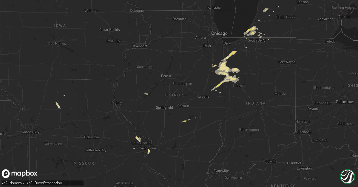
Hail Map in Illinois on August 2, 2018
Get this storm
August 2 map
$229
one time, instant access
Download today. No call, no setup
Keep the $229
Bought the map and want the full workflow? Apply the entire $229 to a subscription within 7 days. None of it is wasted.
Every map, not just this one
This buys you this map. Subscription and you get every map we run, in the markets you choose from a few cities to whole states to nationwide. Plus real-time alerts the moment a storm fires.
Contact data
Name, contact info, occupancy, even credit band for addresses in the footprint. You go from where it hit to who to call.
Become the source they trust
Unlimited branding weather history reports on demand. You already have the documented answer ready for the property owner, and you are the one who showed up with it.
Property data and RoofTrace estimates
Pull up any address you have got, its value and the exact code rules for that jurisdiction, straight from One Click Code. Then RoofTrace estimates the squares, pitch, and roof value, priced the way you price.
Storm reports in Illinois
Illinois
| Date | Description |
|---|---|
| 08/02/20185:51 PM CDT | From wcia |
| 08/02/20185:38 PM CDT | From wics |
| 08/02/20181:47 AM CDT | At 647 PM CDT, a severe thunderstorm was located over Potomac, or 12 miles northwest of Danville, moving northeast at 25 mph. HAZARD...60 mph wind gusts and quarter size hail. SOURCE...Radar indicated. IMPACT...Hail damage to vehicles is expected. Expect wind damage to roofs, siding, and trees. Locations impacted include... Hoopeston, Rossville, Potomac, Bismarck, Henning, Middle Fork Wildlife Area, Armstrong, Collison and Alvin. |
| 08/02/201812:32 AM CDT | At 532 PM CDT, a severe thunderstorm was located over Shelbyville, moving east at 25 mph. HAZARD...60 mph wind gusts and quarter size hail. SOURCE...Radar indicated. IMPACT...Hail damage to vehicles is expected. Expect wind damage to roofs, siding, and trees. Locations impacted include... Shelbyville, Sullivan, Windsor, Findlay, Allenville, Westervelt, Clarksburg, Gays, Wolf Creek State Park, Eagle Creek State Park and Kirksville. |
All States Impacted by Hail Map on August 2, 2018
Cities Impacted by Hail Map on August 2, 2018
- Danville, IL
- Bismarck, IL
- Citra, FL
- Ocala, FL
- Anthony, FL
- Saint Anne, IL
- Martinton, IL
- Clifton, IL
- Kingman, AZ
- Pittsboro, NC
- Donovan, IL
- Pembroke Township, IL
- Kentland, IN
- Morocco, IN
- Brook, IN
- Beaverville, IL
- Goodland, IN
- Belcourt, ND
- Midland, MI
- Pinconning, MI
- Linwood, MI
- Ribera, NM
- Mora, NM
- Lake Village, IN
- O'Fallon, MO
- Brussels, IL
- Golden Eagle, IL
- Bapchule, AZ
- Meadview, AZ
- Lincolnton, NC
- Vale, NC
- Fowler, IN
- Sandy Ridge, NC
- Rensselaer, IN
- Wolcott, IN
- Remington, IN
- Monon, IN
- Erath, LA
- Chillicothe, MO
- Jamesport, MO
- Earl Park, IN
- Hebron, IN
- Pewamo, MI
- Prescott, AZ
- Brookston, IN
- Chalmers, IN
- Galien, MI
- Buchanan, MI
- Berrien Springs, MI
- East Carondelet, IL
- Columbia, IL
- East Saint Louis, IL
- Saint Louis, MO
- Dupo, IL
- Otterbein, IN
- Oxford, IN
- West Lafayette, IN
- Saint Peters, MO
- Winfield, MO
- Saint Charles, MO
- Old Monroe, MO
- New Buffalo, MI
- Walnut Cove, NC
- Ambia, IN
- Hoopeston, IL
- Plainwell, MI
- Maricopa, AZ
- Absarokee, MT
- Hubbardston, MI
- Muir, MI
- Baroda, MI
- Saint Joseph, MI
- Sawyer, MI
- Bridgman, MI
- Stevensville, MI
- Eau Claire, MI
- Sodus, MI
- Lowell, IN
- Shelby, IN
- Demotte, IN
- Bristol, IN
- Browning, IL
- Astoria, IL
- Weidman, MI
- Mount Pleasant, MI
- Remus, MI
- Surprise, AZ
- Tucson, AZ
- Port Hope, MI
- Kirkland, AZ
- Niles, MI
- Watseka, IL
- Potomac, IL
- Rossville, IL
- Boswell, IN
- Sheldon, IL
- Armstrong, IL
- Winston Salem, NC
- Bay City, MI
- Humphreys, MO
- Galt, MO
- Patrick Springs, VA
- Delcambre, LA
- Frankenmuth, MI
- Saginaw, MI
- Reese, MI
- Claremont, NC
- Conover, NC
- Boone Grove, IN
- Kouts, IN
- Thayer, IN
- Valparaiso, IN
- Allegan, MI
- Pullman, MI
- Grand Junction, MI
- Greenville, MI
- Germanton, NC
- Madison, NC
- Lilesville, NC
- Wadesboro, NC
- Bay Port, MI
- New Iberia, LA
- Sells, AZ
- Wittmann, AZ
- Leeds, UT
- Edwardsburg, MI
- Granger, IN
- Peoria, AZ
- Eloy, AZ
- Yucca, AZ
- Troy, NC
- Buckeye, AZ
- Mount Sidney, VA
- Weyers Cave, VA
- Crescent City, IL
- Las Vegas, NM
- Goodyear, AZ
- Rolling Prairie, IN
- Wagon Mound, NM
- Kawkawlin, MI
- Auburn, MI
- Gobles, MI
- Cassopolis, MI
- Dowagiac, MI
- Caseville, MI
- Screven, GA
- Shelbyville, IL
- Saint Albans, MO
- Jacksonville, FL
- Chesterfield, MO
- Defiance, MO
- Durham, NC
- Morrisville, NC
- Findlay, IL
- Hanna, IN
- Perth, ND
- Saint John, ND
- Casa Grande, AZ
- Hamlet, IN
- Lyons, MI
- Fowler, MI
- Ionia, MI
- Pana, IL
- Tower Hill, IL
- Vinton, VA
- Goodview, VA
- Hardy, VA
- Saint Johns, MI
- Myakka City, FL
- Rocklake, ND
- Rolla, ND
- Salisbury, NC
- Newton, NC
- Cherryville, NC
- Coleman, MI
- Rhodes, MI
- Lake City, MI
- Harbert, MI
- Three Oaks, MI
- Berrien Center, MI
- Union Pier, MI
- Lakeside, MI
- Stuart, VA
- Spencer, VA
- Critz, VA
- Bassett, VA
- Searchlight, NV
- Seligman, AZ
- Fort Defiance, VA
- Mount Crawford, VA
- Staunton, VA
- Verona, VA
- Salome, AZ
- Register, GA
- Metter, GA
- Statesboro, GA
- Delton, MI
- Hastings, MI
- New Douglas, IL
- Firth, ID
- Holly Springs, NC
- Apex, NC
- Chebanse, IL
- Gays, IL
- Reynolds, IN
- Schneider, IN
- Wheatfield, IN
- Momence, IL
- Iroquois, IL
- Lawrence, MI
- Hartford, MI
- Otsego, MI
- Lake Panasoffkee, FL
- Dunseith, ND
- Elkhart, IN


