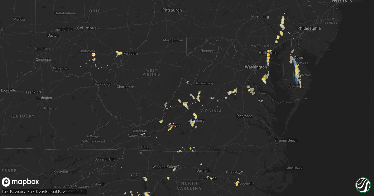
Hail Map in Virginia on August 1, 2019
Get this storm
August 1 map
$229
one time, instant access
Download today. No call, no setup
Keep the $229
Bought the map and want the full workflow? Apply the entire $229 to a subscription within 7 days. None of it is wasted.
Every map, not just this one
This buys you this map. Subscription and you get every map we run, in the markets you choose from a few cities to whole states to nationwide. Plus real-time alerts the moment a storm fires.
Contact data
Name, contact info, occupancy, even credit band for addresses in the footprint. You go from where it hit to who to call.
Become the source they trust
Unlimited branding weather history reports on demand. You already have the documented answer ready for the property owner, and you are the one who showed up with it.
Property data and RoofTrace estimates
Pull up any address you have got, its value and the exact code rules for that jurisdiction, straight from One Click Code. Then RoofTrace estimates the squares, pitch, and roof value, priced the way you price.
Storm reports in Virginia
Virginia
| Date | Description |
|---|---|
| 08/01/20196:59 PM CDT | Trees down along high peak rd. Time estimated by radar. |
| 08/01/20196:56 PM CDT | Trees down along cedar gate rd. Time estimated by radar. |
| 08/01/20196:36 PM CDT | Multiple large branches down in the 300 block of summit street. |
| 08/01/20196:27 PM CDT | Tree blocking both lanes of meeks road near the virginia/north carolina state line. |
| 08/01/20196:19 PM CDT | One large limb blown down along u.s. 60. |
| 08/01/20196:08 PM CDT | One large limb down. |
| 08/01/20195:27 PM CDT | Corrects previous tstm wnd dmg report from 6 sw aiken summit. Tree blocking both lanes of meeks road near the virginia/north carolina state line. |
| 08/01/20195:05 PM CDT | Multiple reports of trees and wires down along us-340 stuarts draft highway. |
| 08/01/20195:04 PM CDT | Multiple trees down in the stuarts draft area. |
| 08/01/20194:36 PM CDT | Up to quarter size hail on barterbrook road. |
| 08/01/20194:35 PM CDT | A local report indicates 1.00 inch wind near 3 NNW RINGGOLD |
| 08/01/20194:20 PM CDT | Numerous large limbs down blocking roads in the city of staunton. |
| 08/01/20194:08 PM CDT | A few trees down near the intersection of cumberland gap road and mountain side drive. Time estimated from radar. |
| 08/01/20194:03 PM CDT | Tree down blocking one lane on johns creek mountain road. Time estimated from radar. |
| 08/01/20194:00 PM CDT | Large tree limbs downed onto power lines at west crawford st and fendall ave. |
| 08/01/20194:00 PM CDT | A couple of trees down. Time estimated from radar. |
| 08/01/20193:48 PM CDT | Close to a dozen trees and other debris down along the length of cumberland gap road south of simmonsville. One tree blocking both lanes of traffic in the 5700 block. T |
| 08/01/20193:35 PM CDT | Tree down on lizzie gunn rd. Time estimated by radar. |
| 08/01/20193:06 PM CDT | Corrects previous tstm wnd dmg report from 2 n indian valley. Tree down on duncan valley road. Time estimated from radar. |
| 08/01/20193:03 PM CDT | Tree down at the intersection of indian creek road and indian valley road. Time estimated from radar. |
| 08/01/20192:37 PM CDT | A local report indicates 1.00 inch wind near 2 E SALEM CITY |
| 08/01/20192:35 PM CDT | Quarter to golf ball size hail reported in southwest roanoke. |
| 08/01/20192:35 PM CDT | A local report indicates 1.25 inch wind near 1 SW ROANOKE |
| 08/01/20192:35 PM CDT | A local report indicates 1.75 inch wind near 2 NE CAVE SPRING |
| 08/01/20192:30 PM CDT | Quarter size hail reported at raleigh court. |
| 08/01/20192:28 PM CDT | Hail up to half dollar size at cave spring post office. |
| 08/01/20192:20 PM CDT | A local report indicates 1.00 inch wind near 1 NW CAVE SPRING |
| 08/01/20195:37 AM CDT | At 1037 PM EDT, a severe thunderstorm was located near Charlottesville, and is nearly stationary. HAZARD...60 mph wind gusts and quarter size hail. SOURCE...Radar indicated. IMPACT...Damaging winds will cause some trees and large branches to fall. This could injure those outdoors, as well as damage homes and vehicles. Roadways may become blocked by downed trees. Localized power outages are possible. Unsecured light objects may become projectiles. Locations impacted include... Charlottesville, Crozet, Westmoreland, Ivy, Overton, Newcomb Hall, Scott Stadium, Monticello, Flordon, Carrsbrook, Barracks and White Hall. |
| 08/01/20194:38 AM CDT | At 938 PM EDT, a severe thunderstorm was located 9 miles southeast of Orange, moving south at 10 mph. HAZARD...60 mph wind gusts and quarter size hail. SOURCE...Radar indicated. IMPACT...Damaging winds will cause some trees and large branches to fall. This could injure those outdoors, as well as damage homes and vehicles. Roadways may become blocked by downed trees. Localized power outages are possible. Unsecured light objects may become projectiles. Locations impacted include... Thornhill, Verdiersville, Unionville, Rhoadesville and Lahore. |
| 08/01/20194:14 AM CDT | At 914 PM EDT, a severe thunderstorm was located near Timberlake, moving southeast at 10 mph. HAZARD...60 mph wind gusts and quarter size hail. SOURCE...Radar indicated. IMPACT...Hail damage to vehicles is expected. Expect wind damage to roofs, siding, and trees. Locations impacted include... Altavista... Brookneal... Rustburg... Evington... and Concord.This includes The following Location Lynchburg Airport. |
| 08/01/20194:02 AM CDT | At 902 PM EDT, a severe thunderstorm was located near Louisa, and is nearly stationary. HAZARD...60 mph wind gusts and quarter size hail. SOURCE...Radar indicated. IMPACT...Minor damage to vehicles is possible. Expect wind damage to trees and powerlines. This severe thunderstorm will be near, Louisa and Mineral around 945 PM EDT.Other locations impacted by this severe thunderstorm includePendleton, Louisa Airport, Green Springs, Byrd Mill, Trevilians,Vawter Corner and Cuckoo. |
| 08/01/20193:57 AM CDT | At 857 PM EDT, a severe thunderstorm was located 12 miles west of Spotsylvania, or 14 miles north of Mineral, and is nearly stationary. HAZARD...60 mph wind gusts and quarter size hail. SOURCE...Radar indicated. IMPACT...Damaging winds will cause some trees and large branches to fall. This could injure those outdoors, as well as damage homes and vehicles. Roadways may become blocked by downed trees. Localized power outages are possible. Unsecured light objects may become projectiles. Locations impacted include... Spotsylvania, Mine Run, Rhoadesville, Brokenburg, Parker, Everona, Verdiersville, Alsop, Gold Dale, Nasons, Logan, Lahore and Unionville. |
| 08/01/20193:47 AM CDT | At 847 PM EDT, a severe thunderstorm was located near Charlottesville, and is nearly stationary. HAZARD...60 mph wind gusts. SOURCE...Radar indicated. IMPACT...Damaging winds will cause some trees and large branches to fall. This could injure those outdoors, as well as damage homes and vehicles. Roadways may become blocked by downed trees. Localized power outages are possible. Unsecured light objects may become projectiles. Locations impacted include... Charlottesville, Westmoreland, Hollymead, Ivy, Overton, Newcomb Hall, Scott Stadium, Monticello, Flordon, Carrsbrook, Shadwell and Barracks. |
| 08/01/20192:44 AM CDT | At 744 PM EDT, a severe thunderstorm was located over Buena Vista, moving south at 5 mph. HAZARD...60 mph wind gusts and quarter size hail. SOURCE...Radar indicated. IMPACT...Hail damage to vehicles is expected. Expect wind damage to roofs, siding, and trees. Locations impacted include... Lynchburg... Buena Vista... Glasgow... Big Island... and Forest. |
| 08/01/20192:06 AM CDT | At 706 PM EDT, a severe thunderstorm was located 7 miles west of Rockbridge Baths, moving south at 10 mph. HAZARD...60 mph wind gusts and quarter size hail. SOURCE...Radar indicated. IMPACT...Hail damage to vehicles is expected. Expect wind damage to roofs, siding, and trees. Locations impacted include... Lexington... and Collierstown.This includes The following Location VMI. |
| 08/01/20192:05 AM CDT | At 704 PM EDT, a severe thunderstorm was located near Kingsport, moving southwest at 10 mph. HAZARD...60 mph wind gusts and quarter size hail. SOURCE...Radar indicated. IMPACT...Hail damage to vehicles is expected. Expect wind damage to roofs, siding, and trees. Locations impacted include... Kingsport, Bristol Tn, Weber City, Colonial Heights, Spurgeon, Church Hill, Mount Carmel, Tri-City Airport, Blountville, Bays Mountain Park, Sullivan Gardens, Warriors Path State Park and Bloomingdale. |
| 08/01/20191:25 AM CDT | At 624 PM EDT, a severe thunderstorm was located over Rockbridge Baths, and is nearly stationary. HAZARD...60 mph wind gusts and quarter size hail. SOURCE...Radar indicated. IMPACT...Hail damage to vehicles is expected. Expect wind damage to roofs, siding, and trees. Locations impacted include... Rockbridge Baths... Fairfield... Brownsburg... and Vesuvius. |
| 08/01/20191:03 AM CDT | At 602 PM EDT, a severe thunderstorm was located over Stuarts Draft, or 9 miles southwest of Waynesboro, moving southeast at 10 mph. HAZARD...60 mph wind gusts. SOURCE...Radar indicated. IMPACT...Damaging winds will cause some trees and large branches to fall. This could injure those outdoors, as well as damage homes and vehicles. Roadways may become blocked by downed trees. Localized power outages are possible. Unsecured light objects may become projectiles. Locations impacted include... Stuarts Draft, Sherando, Wintergreen, Lyndhurst, Nellysford and Greenville. |
| 08/01/201912:44 AM CDT | At 544 PM EDT, a severe thunderstorm was located near Alvon, moving southeast at 10 mph. HAZARD...60 mph wind gusts and quarter size hail. SOURCE...Radar indicated. IMPACT...Hail damage to vehicles is expected. Expect wind damage to roofs, siding, and trees. Locations impacted include... Alleghany... Covington... Clifton Forge... White Sulphur Springs... and Neola. |
| 08/01/201912:32 AM CDT | At 531 PM EDT, a severe thunderstorm was located near Stuarts Draft, or near Staunton, moving southeast at 10 mph. HAZARD...60 mph wind gusts and quarter size hail. SOURCE...Radar indicated. IMPACT...Damaging winds will cause some trees and large branches to fall. This could injure those outdoors, as well as damage homes and vehicles. Roadways may become blocked by downed trees. Localized power outages are possible. Unsecured light objects may become projectiles. Locations impacted include... Staunton, Waynesboro, Stuarts Draft, Sherando, Fishersville, Lyndhurst and Mint Spring. |
| 08/01/201912:15 AM CDT | At 514 PM EDT, a severe thunderstorm was located 10 miles southwest of Staunton, moving east at 5 mph. HAZARD...60 mph wind gusts. SOURCE...Radar indicated. IMPACT...Damaging winds will cause some trees and large branches to fall. This could injure those outdoors, as well as damage homes and vehicles. Roadways may become blocked by downed trees. Localized power outages are possible. Unsecured light objects may become projectiles. Locations impacted include... Craigsville, Augusta Springs, Middlebrook, Buffalo Gap, Summerdean, Trimbles Mill, Christian, Mint Spring and Swoope. |
| 08/01/201912:04 AM CDT | At 504 PM EDT, a severe thunderstorm was located over Staunton, and is nearly stationary. HAZARD...60 mph wind gusts. SOURCE...Radar indicated. IMPACT...Damaging winds will cause some trees and large branches to fall. This could injure those outdoors, as well as damage homes and vehicles. Roadways may become blocked by downed trees. Localized power outages are possible. Unsecured light objects may become projectiles. Locations impacted include... Staunton, Fishersville, Verona, New Hope, Mount Sidney and Fort Defiance. |
| 07/31/201911:51 PM CDT | At 451 PM EDT, a severe thunderstorm was located over Richmond, and is nearly stationary. HAZARD...60 mph wind gusts and quarter size hail. SOURCE...Radar indicated. IMPACT...Minor damage to vehicles is possible. Expect wind damage to trees and powerlines. This severe thunderstorm will be near, Bensley around 455 PM EDT. Highland Springs around 515 PM EDT.Other locations impacted by this severe thunderstorm include Montroseand Richmond Heights. |
| 07/31/201911:39 PM CDT | At 439 PM EDT, a severe thunderstorm was located 9 miles northeast of Bells Valley, or 14 miles northeast of Goshen, and is nearly stationary. HAZARD...60 mph wind gusts. SOURCE...Radar indicated. IMPACT...Damaging winds will cause some trees and large branches to fall. This could injure those outdoors, as well as damage homes and vehicles. Roadways may become blocked by downed trees. Localized power outages are possible. Unsecured light objects may become projectiles. Locations impacted include... Craigsville, Augusta Springs, Christian, Buffalo Gap, Swoope and Trimbles Mill. |
| 07/31/201911:30 PM CDT | At 430 PM EDT, a severe thunderstorm was located near Long Spur, moving northeast at 15 mph. HAZARD...60 mph wind gusts and half dollar size hail. SOURCE...Radar indicated. IMPACT...Hail damage to vehicles is expected. Expect wind damage to roofs, siding, and trees. Locations impacted include... Radford... Pulaski... Wytheville... Bland... and Pearisburg. |
| 07/31/201911:28 PM CDT | At 428 PM EDT, a severe thunderstorm was located near Mc Donalds Mill, moving east at 10 mph. HAZARD...60 mph wind gusts and quarter size hail. SOURCE...Radar indicated. IMPACT...Hail damage to vehicles is expected. Expect wind damage to roofs, siding, and trees. Locations impacted include... Blacksburg... Christiansburg... Pembroke... New Castle... and Newport.This includes The following Location Virginia Tech. |
| 07/31/201911:18 PM CDT | At 418 PM EDT, a severe thunderstorm was located near Claytor Lake State Park, moving east at 10 mph. HAZARD...60 mph wind gusts and quarter size hail. SOURCE...Radar indicated. IMPACT...Hail damage to vehicles is expected. Expect wind damage to roofs, siding, and trees. Locations impacted include... Christiansburg... Pulaski... Floyd... Indian Valley... and Pilot. |
| 07/31/201911:02 PM CDT | At 402 PM EDT, a severe thunderstorm was located 8 miles northeast of Monterey, moving northeast at 10 mph. HAZARD...60 mph wind gusts. SOURCE...Radar indicated. IMPACT...Damaging winds will cause some trees and large branches to fall. This could injure those outdoors, as well as damage homes and vehicles. Roadways may become blocked by downed trees. Localized power outages are possible. Unsecured light objects may become projectiles. Locations impacted include... Sugar Grove, Doe Hill, Harper, Moyers and Palo Alto. |
| 07/31/201910:17 PM CDT | At 316 PM EDT, a severe thunderstorm was located over Copper Valley, moving northeast at 10 mph. HAZARD...60 mph wind gusts and quarter size hail. SOURCE...Radar indicated. IMPACT...Hail damage to vehicles is expected. Expect wind damage to roofs, siding, and trees. Locations impacted include... Christiansburg... Indian Valley... Pilot... Terrys Fork... and Alum Ridge. |
| 07/31/201910:16 PM CDT | Tree down on the 4000 block of turkey sag road. |
| 07/31/201910:03 PM CDT | At 303 PM EDT, a severe thunderstorm was located over Bent Mountain, moving northeast at 10 mph. HAZARD...60 mph wind gusts and quarter size hail. SOURCE...Radar indicated. IMPACT...Hail damage to vehicles is expected. Expect wind damage to roofs, siding, and trees. Locations impacted include... Roanoke... Salem... Vinton... Bent Mountain... and Catawba.This includes The following Locations The Salem Fairgrounds andRoanoke Regional Airport. |
| 07/31/20199:40 PM CDT | Tree down on richmond road near peter jefferson parkway. |
| 07/31/20198:48 PM CDT | Very large tree down across the 19400 block of lahore road. |
| 07/31/20198:44 PM CDT | Trees down near the intersection of va-669 marquis road and va-629 lahore road. |
| 07/31/20198:40 PM CDT | Two large trees down near the intersection of va-612 monrovia road and brick church road. |
| 07/31/20198:40 PM CDT | Trees down near the intersection of va-650 independence road and magnolia ridge drive. |
| 07/31/20198:30 PM CDT | Tree and wires down near the intersection of va-810 browns gap turnpike and blufton road. |
| 07/31/20198:30 PM CDT | Tree down near the intersection of independence road and daffodil lane. |
| 07/31/20198:20 PM CDT | Tree down on town fork rd. Time estimated by radar. |
| 07/31/20198:19 PM CDT | Several tops of trees snapped off. Time estimated by radar. |
| 07/31/20198:15 PM CDT | Trees downed on us-33 in louisa at foxwood. Time is radar estimated. |
| 07/31/20198:06 PM CDT | Tree down on ivy lane near morgantown road. |
| 07/31/20197:55 PM CDT | Dime to quarter size hail |
| 07/31/20197:41 PM CDT | Tree and power lines blocking college ave in lynchburg. Time estimated by radar. |
| 07/31/20197:25 PM CDT | Trees down around link rd. |
| 07/31/20197:00 PM CDT | Emergency manager reported a barn destroyed and car flipped in the cedar gate rd and high peak rd area of amherst county. Time is estimated by radar. |
All States Impacted by Hail Map on August 1, 2019
Cities Impacted by Hail Map on August 1, 2019
- Orangeburg, SC
- El Dorado, KS
- Forsyth, MT
- Akron, CO
- Sudlersville, MD
- Millington, MD
- Dallas, NC
- Gastonia, NC
- Bay Minette, AL
- Atlanta, GA
- Holly, CO
- Blacksburg, SC
- Inkom, ID
- Staunton, VA
- Marion, SC
- Mullins, SC
- Dillon, SC
- Fork, SC
- Brush, CO
- Waverly, AL
- Blackville, SC
- Denmark, SC
- Intercourse, PA
- Paradise, PA
- Kinzers, PA
- Ronks, PA
- Gordonville, PA
- Bird In Hand, PA
- Simpson, KS
- Beloit, KS
- Glasco, KS
- Waynesboro, GA
- Tampa, KS
- Brooklyn, MD
- Springerville, AZ
- Cuba, AL
- Lauderdale, MS
- Beulah, ND
- Stoneham, CO
- Atwood, CO
- Sterling, CO
- Merino, CO
- Seaford, DE
- Harrington, DE
- Georgetown, DE
- Laurel, DE
- Bridgeville, DE
- Greenwood, DE
- Mandaree, ND
- Killdeer, ND
- Hinton, WV
- Daniels, WV
- Shady Spring, WV
- Courtenay, ND
- Durham, KS
- Bremen, GA
- Buchanan, GA
- Roundup, MT
- Douglass, KS
- Severna Park, MD
- Crownsville, MD
- Millersville, MD
- Garrison, KY
- Olive Hill, KY
- Salem, AL
- Clermont, FL
- Grover, CO
- Carpenter, WY
- Pine Bluffs, WY
- Haswell, CO
- Eads, CO
- Fort Benning, GA
- Cusseta, GA
- Salem, VA
- Roanoke, VA
- Statesville, NC
- Kimball, NE
- Dix, NE
- Limon, CO
- Ramah, CO
- Matheson, CO
- Hugo, CO
- Lafayette, AL
- Jackson, OH
- Stuarts Draft, VA
- Mooresboro, NC
- Spotsylvania, VA
- Leon, KS
- Augusta, KS
- Peach Bottom, PA
- Kirkwood, PA
- Nottingham, PA
- Oxford, PA
- Quarryville, PA
- New Castle, VA
- Karval, CO
- Agate, CO
- Raleigh, NC
- Dothan, AL
- Headland, AL
- Hughesville, MD
- Charlotte Hall, MD
- Mechanicsville, MD
- Alliance, NE
- Cohagen, MT
- Pisgah, AL
- Henagar, AL
- Jewell, KS
- Formoso, KS
- Courtland, KS
- Jamestown, KS
- Norway, KS
- Carrollton, GA
- Roopville, GA
- Franklin, GA
- Troutman, NC
- Whitmire, SC
- Lexington, VA
- Garrison, ND
- Arkansas City, KS
- Winfield, KS
- Hemingford, NE
- Ider, AL
- Greensboro, NC
- Jamestown, NC
- Dazey, ND
- Otis, CO
- Curtis Bay, MD
- Pasadena, MD
- Halethorpe, MD
- Baltimore, MD
- Glen Burnie, MD
- Harrison, NE
- Stevens, PA
- Reinholds, PA
- Denver, PA
- Christiana, PA
- Smoketown, PA
- Terre Hill, PA
- Adamstown, PA
- East Earl, PA
- Mohnton, PA
- Ephrata, PA
- Leola, PA
- New Holland, PA
- Forest Hill, MD
- Bel Air, MD
- Arnegard, ND
- Craigsville, VA
- Greenville, VA
- Middlebrook, VA
- Swoope, VA
- Charlottesville, VA
- Axton, VA
- Ridgeway, VA
- Cascade, VA
- Boones Mill, VA
- Fayetteville, TN
- Kelso, TN
- Watford City, ND
- Vass, NC
- New Salem, ND
- Woodville, AL
- Scottsboro, AL
- Gaffney, SC
- Hope, KS
- Whiteford, MD
- Delta, PA
- Webster Springs, WV
- Mulberry, TN
- Winnsboro, SC
- Sanborn, ND
- Esbon, KS
- Havelock, NC
- Lynchburg, VA
- Evington, VA
- Taylors, SC
- Greenville, SC
- Travelers Rest, SC
- Ranburne, AL
- Heflin, AL
- Five Points, AL
- Towanda, KS
- Forest, VA
- Bighorn, MT
- Resaca, GA
- Hamer, SC
- Brockton, MT
- Waldorf, MD
- Brandywine, MD
- Bryantown, MD
- Aquasco, MD
- Florala, AL
- Andalusia, AL
- Angela, MT
- Sparta, NC
- Georgetown, GA
- Fort Gaines, GA
- Morris, GA
- Goshen, VA
- Ray, OH
- Londonderry, OH
- Chillicothe, OH
- Walstonburg, NC
- Farmville, NC
- Fountain, NC
- Stantonsburg, NC
- Rainelle, WV
- Millboro, VA
- Hillrose, CO
- Rowland, NC
- Derby, KS
- Lumberton, NC
- Lehigh, KS
- Rose Hill, KS
- Syracuse, KS
- Lexington, NC
- Thomasville, NC
- Pettibone, ND
- Fort Morgan, CO
- Henderson, MD
- Hartly, DE
- Houston, DE
- Marydel, DE
- Camden Wyoming, DE
- Marydel, MD
- Goldsboro, MD
- Barclay, MD
- Ellendale, DE
- Greensboro, MD
- Felton, DE
- Chesnee, SC
- Anderson, SC
- Malta, ID
- Hereford, CO
- Delmar, MD
- Delmar, DE
- Amherst, VA
- Madison Heights, VA
- Monroe, VA
- Rappahannock Academy, VA
- King George, VA
- Solomon, KS
- Wing, ND
- Bent Mountain, VA
- Newport, VA
- Copper Hill, VA
- Cartwright, ND
- Williston, ND
- Fairview, MT
- Armuchee, GA
- Calhoun, GA
- Sugar Valley, GA
- Roanoke, AL
- Blackfoot, ID
- Eden, NC
- Sugar Grove, WV
- Bainville, MT
- Prosperity, SC
- Pomaria, SC
- Alexander, ND
- Mankato, KS
- Troy, VA
- Raphine, VA
- Coolville, OH
- Guysville, OH
- Hysham, MT
- Sanders, MT
- Wyndmere, ND
- Newark, DE
- Mill Creek, WV
- Atlanta, KS
- Charlotte, NC
- Millen, GA
- Perkins, GA
- Columbus, ND
- Bidwell, OH
- Gallipolis, OH
- Forkland, AL
- Hazen, ND
- Ririe, ID
- Dunn Center, ND
- Marietta, GA
- Keene, ND
- Lewistown, MT
- Briggsdale, CO
- Yanceyville, NC
- Marion, KS
- Hillsboro, KS
- Waverly, OH
- Rockford, AL
- Delphos, KS
- Minneapolis, KS
- Dalton, GA
- Chatsworth, GA
- Zap, ND
- Shelby, NC
- Cherryville, NC
- Huntersville, NC
- Dallas, GA
- White Sulphur Springs, WV
- Roggen, CO
- Lebanon, KS
- Lanett, AL
- Kit Carson, CO
- Peterman, AL
- Monroeville, AL
- Homestead, MT
- Louisville, TN
- Knoxville, TN
- Newberry, SC
- Blair, SC
- Norway, SC
- McDavid, FL
- Beaver, OH
- Tarboro, NC
- Rocky Mount, NC
- Rockmart, GA
- Street, MD
- Honoraville, AL
- Greenville, AL
- Ash, NC
- Snyder, CO
- Louisa, VA
- Gordonsville, VA
- Goode, VA
- Burns, KS
- Potwin, KS
- Boligee, AL
- Minatare, NE
- Benedict, ND
- Crossville, TN
- Unionville, VA
- Orange, VA
- Oxford, KS
- Udall, KS
- Belle Plaine, KS
- Nichols, SC
- Athens, OH
- Stewart, OH
- Cutler, OH
- Little Hocking, OH
- Padroni, CO
- Halliday, ND
- Pinetta, FL
- Madison, FL
- Lincolnville, KS
- West End, NC
- Verona, VA
- Nashville, GA
- Harman, WV
- Lakemont, GA
- Musselshell, MT
- Aiken, SC
- Ridge Spring, SC
- Scenic, SD
- Massey, MD
- Clayton, DE
- Galena, MD
- Townsend, DE
- Lancaster, SC
- Jennings, FL
- Lake Park, GA
- Philip, SD
- Wytheville, VA
- Latta, SC
- Salina, KS
- Harrisburg, NE
- Rougemont, NC
- Bahama, NC
- Hillsborough, NC
- Virginia City, MT
- Century, FL
- Bayard, NE
- Milton, NC
- Ringgold, VA
- Darlington, MD
- Lyerly, GA
- New Raymer, CO
- Woodland, AL
- Waco, GA
- Show Low, AZ
- Lakeside, AZ
- Pinetop, AZ
- Shade, OH
- Tappahannock, VA
- Garner, NC
- Annapolis, MD
- Gap, PA
- Reading, PA
- Lancaster, PA
- Alton, VA
- Mobile, AL
- Lucedale, MS
- Wilmer, AL
- Brookwood, AL
- Middleport, OH
- Bristol, TN
- Bluff City, TN
- Kingsport, TN
- Byers, CO
- Boiling Springs, SC
- Rockbridge Baths, VA
- Covington, VA
- Newkirk, OK
- Kings Mountain, NC
- Lower Peach Tree, AL
- Semmes, AL
- Culbertson, MT
- Valley Center, KS
- Lambert, MT
- Fredericksburg, VA
- Stone Mountain, GA
- Pine Lake, GA
- Ellerbe, NC
- Blountsville, AL
- Clayton, GA
- West Columbia, WV
- Burgaw, NC
- Rocky Point, NC
- Vinton, VA
- Fishersville, VA
- Rosebud, MT
- Midland City, AL
- Callaway, VA
- Severn, MD
- Riva, MD
- Gambrills, MD
- Davidsonville, MD
- Decatur, AL
- Clarkrange, TN
- Auburn, AL
- Opelika, AL
- Ramona, KS
- Lima, MT
- Owings, MD
- Tracys Landing, MD
- Friendship, MD
- Sunderland, MD
- Dunkirk, MD
- Huntingtown, MD
- Lothian, MD
- Buffalo, WV
- Quitman, MS
- Dexter, GA
- Dudley, GA
- Great Falls, SC
- Blackstock, SC
- Fairmount, GA
- Midway Park, NC
- Hubert, NC
- Jacksonville, NC
- Maysville, NC
- Camp Lejeune, NC
- Senoia, GA
- Madison, AL
- Locust Grove, VA
- Epping, ND
- Lake Toxaway, NC
- Maxton, NC
- Pocatello, ID
- West Grove, PA
- Cochranville, PA
- Rustburg, VA
- Pembroke, NC
- Fairmont, NC
- Collettsville, NC
- Blowing Rock, NC
- Steele, ND
- Tuttle, ND
- Inman, SC
- Conowingo, MD
- Peabody, KS
- Timmonsville, SC
- Wiggins, CO
- Oak Hill, OH
- Smoot, WV
- Alapaha, GA
- Hiwassee, VA
- Keenesburg, CO
- Bennett, CO
- Adger, AL
- Rosedale, MD
- Loris, SC
- Easley, SC
- Newton, KS
- Mount Gilead, NC
- Gering, NE
- Port Royal, VA
- Bowbells, ND
- Benton, KS
- Wichita, KS
- Andover, KS
- Golden Valley, ND
- Doe Hill, VA
- Stafford, VA
- Talladega, AL
- Winterville, NC
- Greenville, NC
- Atmore, AL
- Danville, VA
- Anton, CO
- Lindon, CO
- Whitewater, KS
- Florence, KS
- Piketon, OH
- Payson, AZ
- Forest Grove, MT
- High Point, NC
- Mount Holly, NC
- Currie, NC
- Buena Vista, GA
- Box Springs, GA
- Crossville, AL
- Albertville, AL
- Geraldine, AL
- Abilene, KS
- Jackson Springs, NC
- Mineral, VA
- Loretto, VA
- Groveland, FL
- Lenox, GA
- Glendive, MT
- Bridgeport, NE
- Kenmare, ND
- Gaylesville, AL
- Big Timber, MT
- Heath Springs, SC
- Atkinson, NC
- Toomsuba, MS
- Chester, GA
- Seneca, SC
- Townville, SC
- Hudson, NC
- Granite Falls, NC
- Coolidge, KS
- Vance, AL
- Otway, OH
- Peebles, OH
- Deer Trail, CO
- Dover, DE
- Nottingham, MD
- Duluth, GA
- Norcross, GA
- Rocky Face, GA
- Wall, SD
- New Town, ND
- Randall, KS
- Valley City, ND
- Sutherlin, VA
- Richey, MT
- Mulvane, KS
- Willis, VA
- Lilesville, NC
- Meridian, MS
- Fraziers Bottom, WV
- Fort Lawn, SC
- Minford, OH
- Fairfield, VA
- Sidney, NE
- Fleetwood, NC
- Campobello, SC
- Addison, AL
- Ovett, MS
- Citronelle, AL
- Angora, NE
- Roseland, VA
- Clay Center, KS
- Elm City, NC
- Robinson, ND
- Douglas, ND
- Warsaw, VA
- Tazewell, TN
- Barnard, KS
- Tescott, KS
- Evergreen, AL
- Taylorsville, NC
- Concord, VA
- Rogers, ND
- Scottsville, VA
- Max, ND
- Richmond, VA
- Hendersonville, NC
- Livingston, MT
- Parsonsburg, MD
- Salisbury, MD
- Selden, KS
- Chester, SC
- Needham, AL
- Lamont, FL
- Macclesfield, NC
- Pinetops, NC
- Groveoak, AL
- Fyffe, AL
- Bethel, DE
- Macon, GA
- Cadwell, GA
- Piedmont, AL
- Glade Valley, NC
- Wilson, NC
- Blountville, TN


