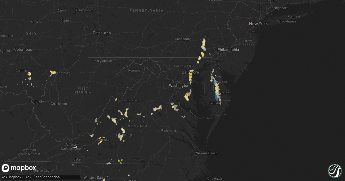
Hail Map in Maryland on August 1, 2019
Get this storm
August 1 map
$229
one time, instant access
Download today. No call, no setup
Keep the $229
Bought the map and want the full workflow? Apply the entire $229 to a subscription within 7 days. None of it is wasted.
Every map, not just this one
This buys you this map. Subscription and you get every map we run, in the markets you choose from a few cities to whole states to nationwide. Plus real-time alerts the moment a storm fires.
Contact data
Name, contact info, occupancy, even credit band for addresses in the footprint. You go from where it hit to who to call.
Become the source they trust
Unlimited branding weather history reports on demand. You already have the documented answer ready for the property owner, and you are the one who showed up with it.
Property data and RoofTrace estimates
Pull up any address you have got, its value and the exact code rules for that jurisdiction, straight from One Click Code. Then RoofTrace estimates the squares, pitch, and roof value, priced the way you price.
Storm reports in Maryland
Maryland
| Date | Description |
|---|---|
| 08/01/20195:55 PM CDT | Six inch diameter limbs down. |
| 08/01/20195:54 PM CDT | Reports of trees down on wires near mechanicsville. |
| 08/01/20195:50 PM CDT | Four large trees and numerous limbs down in the area of bach drive in charlotte hall. |
| 08/01/20195:40 PM CDT | Multiple trees down in the bryantown and hughesville area. |
| 08/01/20195:40 PM CDT | Four large trees and numerous limbs down in the area of bach drive in charlotte hall. Corrected event time. |
| 08/01/20195:20 PM CDT | Trees down along highway 50 in salisbury. |
| 08/01/20195:20 PM CDT | Reports of trees down on power lines in mardela springs. |
| 08/01/20195:20 PM CDT | A local report indicates 1.25 inch wind near 3 N HUGHESVILLE |
| 08/01/20193:49 PM CDT | Tree down in the 700 block of md-136 priestford road. |
| 08/01/20193:25 PM CDT | Tree down near the intersection of md-136 calvary road and schucks road. |
| 08/01/20193:15 PM CDT | Wires down near the intersection of paddrick road and huneke lane. |
| 08/01/20192:01 PM CDT | A local report indicates 1.00 inch wind near 2 E SEVERN |
| 08/01/20191:57 PM CDT | A local report indicates 1.00 inch wind near 1 NW GLEN BURNIE |
| 08/01/20191:56 PM CDT | Tree down on a car partially blocking rita drive. |
| 08/01/20191:45 PM CDT | Hail up to golf ball size off furnace branch road in glen burnie. |
| 08/01/20191:43 PM CDT | Tree down onto house in the 100 block of raplh road. |
| 08/01/20191:40 AM CDT | At 640 PM EDT, a severe thunderstorm was located near Golden Beach, or near Hallowing Point, moving south at 15 mph. HAZARD...60 mph wind gusts and quarter size hail. SOURCE...Radar indicated. IMPACT...Damaging winds will cause some trees and large branches to fall. This could injure those outdoors, as well as damage homes and vehicles. Roadways may become blocked by downed trees. Localized power outages are possible. Unsecured light objects may become projectiles. Locations impacted include... Waldorf, Leonardtown, Hallowing Point, Saint Clements Bay, Wicomico River, Golden Beach, Wicomico, Hughesville, Mechanicsville, Charlotte Hall, Cobb Island, Aquasco, Bryantown, Benedict, Rock Point, Eagle Harbor, Bushwood, Clements, Issue and Tompkinsville. |
| 08/01/20191:01 AM CDT | At 601 PM EDT, a severe thunderstorm was located near Dunkirk, or 9 miles west of Chesapeake Beach, moving south at 10 mph. HAZARD...60 mph wind gusts and quarter size hail. SOURCE...Radar indicated. IMPACT...Damaging winds will cause some trees and large branches to fall. This could injure those outdoors, as well as damage homes and vehicles. Roadways may become blocked by downed trees. Localized power outages are possible. Unsecured light objects may become projectiles. Locations impacted include... Prince Frederick, Hallowing Point, Sheridan Point, Golden Beach, Dunkirk, Saint Leonard, Huntingtown, Hughesville, Baden, Mechanicsville, Charlotte Hall, Aquasco, Benedict, Eagle Harbor, Lower Marlboro, Barstow and Port Republic. |
| 08/01/201912:28 AM CDT | At 528 PM EDT, a severe thunderstorm was located over Seaford, or 12 miles west of Georgetown, moving south at 15 mph. HAZARD...60 mph wind gusts and quarter size hail. SOURCE...Radar indicated. IMPACT...Minor damage to vehicles is possible. Wind damage to roofs, siding, trees, and power lines is possible. Locations impacted include... Seaford, Laurel, Delmar, Sycamore, Blades and Bethel. |
| 07/31/201911:47 PM CDT | At 447 PM EDT, a severe thunderstorm was located near Bel Air North, or 8 miles northwest of Aberdeen, moving south at 5 mph. HAZARD...60 mph wind gusts. SOURCE...Radar indicated. IMPACT...Damaging winds will cause some trees and large branches to fall. This could injure those outdoors, as well as damage homes and vehicles. Roadways may become blocked by downed trees. Localized power outages are possible. Unsecured light objects may become projectiles. Locations impacted include... Aberdeen, Aberdeen Proving Ground, Bel Air South, Bel Air North, Fallston, Riverside, Pleasant Hills, Perryman, Benson, Churchville, Carsins, Forest Hill, Chrome Hill, Bynum, Harford Furnace, Rocks, Hickory and Belcamp. |
| 07/31/201911:41 PM CDT | At 440 PM EDT, a severe thunderstorm was located over Stanton, or near Newark, moving south at 10 mph. HAZARD...60 mph wind gusts and quarter size hail. SOURCE...Radar indicated. IMPACT...Minor damage to vehicles is possible. Wind damage to roofs, siding, trees, and power lines is possible. Locations impacted include... Wilmington, Newark, Elkton, Elsmere, New Castle, Delaware City, Newport, Barksdale, Stanton, North Star, Glasgow, Bear, Brantwood, Wilmington Manor, Pike Creek, Fair Hill, Glen Westover, Saint Georges, Greenville and Andora. |
| 07/31/201911:09 PM CDT | At 408 PM EDT, a severe thunderstorm was located near Rock Springs, moving southeast at 15 mph. HAZARD...60 mph wind gusts and quarter size hail. SOURCE...Radar indicated. IMPACT...Hail damage to vehicles is expected. Expect wind damage to trees, roofs, and siding. Locations impacted include... Wakefield, Little Britain and Peach Bottom. |
| 07/31/201911:02 PM CDT | At 402 PM EDT, a severe thunderstorm was located over Rock Springs, or 12 miles north of Havre De Grace, moving southeast at 15 mph. HAZARD...60 mph wind gusts and quarter size hail. SOURCE...Radar indicated. IMPACT...Minor damage to vehicles is possible. Wind damage to roofs, siding, trees, and power lines is possible. Locations impacted include... Elkton, Calvert, North East, Rising Sun, Charlestown, Zion, Blake, Lombard, Richardsmere, Woodlawn, West Nottingham, Octoraro, Pleasant Hill, Conowingo, Rock Springs, Bay View, Farmington, Perryville and Port Deposit. |
| 07/31/201911:00 PM CDT | At 400 PM EDT, a severe thunderstorm was located near Wakefield, or 15 miles northwest of Havre De Grace, moving southeast at 10 mph. HAZARD...60 mph wind gusts and quarter size hail. SOURCE...Radar indicated. IMPACT...Damaging winds will cause some trees and large branches to fall. This could injure those outdoors, as well as damage homes and vehicles. Roadways may become blocked by downed trees. Localized power outages are possible. Unsecured light objects may become projectiles. Locations impacted include... Aberdeen, Havre De Grace, Bel Air South, Bel Air North, Pylesville, Darlington, Cardiff, Churchville, Carsins, Scarboro, Bynum, Harford Furnace, Street, Hickory and Whiteford. |
| 07/31/201910:24 PM CDT | At 323 PM EDT, a severe thunderstorm was located over Gap, or 9 miles southeast of New Holland, moving southeast at 10 mph. HAZARD...60 mph wind gusts and quarter size hail. SOURCE...Radar indicated. IMPACT...Minor damage to vehicles is possible. Wind damage to roofs, siding, trees, and power lines is possible. Locations impacted include... Coatesville, Oxford, Parkesburg, West Grove, Homeville, Glen Roy, Cochranville, Mount Vernon, Marshallton, Atglen, South Coatesville, Christiana, Modena and Thorndale. |
| 07/31/201910:14 PM CDT | At 314 PM EDT, a severe thunderstorm was located over Millersville, or near Crofton, moving south at 30 mph. HAZARD...60 mph wind gusts and quarter size hail. SOURCE...Radar indicated. IMPACT...Damaging winds will cause some trees and large branches to fall. This could injure those outdoors, as well as damage homes and vehicles. Roadways may become blocked by downed trees. Localized power outages are possible. Unsecured light objects may become projectiles. Locations impacted include... Bowie, Severn, Annapolis, Crofton, Mayo, Shady Side, Deale, Upper Marlboro, Rhode River, Glen Burnie, Severna Park, Odenton, Pasadena, Arnold, Lake Shore, Parole, Millersville, Londontowne, South Gate and Edgewater. |
| 07/31/20199:51 PM CDT | At 250 PM EDT, a severe thunderstorm was located over Glen Burnie, or near Baltimore-Washington Airport, moving south at 20 mph. HAZARD...60 mph wind gusts and quarter size hail. SOURCE...Radar indicated. IMPACT...Damaging winds will cause some trees and large branches to fall. This could injure those outdoors, as well as damage homes and vehicles. Roadways may become blocked by downed trees. Localized power outages are possible. Unsecured light objects may become projectiles. Locations impacted include... Severn, Crofton, Riviera Beach, Baltimore-Washington Airport, Glen Burnie, Severna Park, Odenton, Pasadena, Arnold, Lake Shore, Ferndale, Parole, Millersville, South Gate, Green Haven, Linthicum, Gambrills, Herald Harbor, Crownsville and Chelsea Beach. |
| 07/31/20199:29 PM CDT | At 229 PM EDT, a severe thunderstorm was located over Brooklyn Park, or near Baltimore, moving southeast at 10 mph. HAZARD...60 mph wind gusts and quarter size hail. SOURCE...Radar indicated. IMPACT...Damaging winds will cause some trees and large branches to fall. This could injure those outdoors, as well as damage homes and vehicles. Roadways may become blocked by downed trees. Localized power outages are possible. Unsecured light objects may become projectiles. Locations impacted include... Baltimore, Glen Burnie, Dundalk, Catonsville, Pasadena, Arbutus, Ferndale, Brooklyn Park, Pumphrey, Linthicum, Edgemere, Lansdowne, Halethorpe, Turners Station and Linthicum Heights. |
| 07/31/20199:09 PM CDT | At 208 PM EDT, a severe thunderstorm was located over Baltimore, moving southeast at 15 mph. HAZARD...60 mph wind gusts and quarter size hail. SOURCE...Radar indicated. IMPACT...Damaging winds will cause some trees and large branches to fall. This could injure those outdoors, as well as damage homes and vehicles. Roadways may become blocked by downed trees. Localized power outages are possible. Unsecured light objects may become projectiles. Locations impacted include... Baltimore, Middle River, Dundalk, Towson, Essex, Parkville, Rosedale, Rossville, White Marsh, Fullerton, Eudowood, Eastpoint, Loch Raven Village, Martin State Airport and Turners Station. |
| 07/31/20198:38 PM CDT | At 138 PM EDT, a severe thunderstorm was located over Rossville, or over Middle River, moving southeast at 5 mph. HAZARD...60 mph wind gusts and quarter size hail. SOURCE...Radar indicated. IMPACT...Damaging winds will cause some trees and large branches to fall. This could injure those outdoors, as well as damage homes and vehicles. Roadways may become blocked by downed trees. Localized power outages are possible. Unsecured light objects may become projectiles. Locations impacted include... Baltimore, Middle River, North Point State Park, Back River, Millers Island, Dundalk, Essex, Parkville, Carney, Perry Hall, Rosedale, Rossville, White Marsh, Bowleys Quarters, Edgemere, Nottingham, Fort Howard, Fullerton, Chase and Eastpoint. |
All States Impacted by Hail Map on August 1, 2019
Cities Impacted by Hail Map on August 1, 2019
- Orangeburg, SC
- El Dorado, KS
- Forsyth, MT
- Akron, CO
- Sudlersville, MD
- Millington, MD
- Dallas, NC
- Gastonia, NC
- Bay Minette, AL
- Atlanta, GA
- Holly, CO
- Blacksburg, SC
- Inkom, ID
- Staunton, VA
- Marion, SC
- Mullins, SC
- Dillon, SC
- Fork, SC
- Brush, CO
- Waverly, AL
- Blackville, SC
- Denmark, SC
- Intercourse, PA
- Paradise, PA
- Kinzers, PA
- Ronks, PA
- Gordonville, PA
- Bird In Hand, PA
- Simpson, KS
- Beloit, KS
- Glasco, KS
- Waynesboro, GA
- Tampa, KS
- Brooklyn, MD
- Springerville, AZ
- Cuba, AL
- Lauderdale, MS
- Beulah, ND
- Stoneham, CO
- Atwood, CO
- Sterling, CO
- Merino, CO
- Seaford, DE
- Harrington, DE
- Georgetown, DE
- Laurel, DE
- Bridgeville, DE
- Greenwood, DE
- Mandaree, ND
- Killdeer, ND
- Hinton, WV
- Daniels, WV
- Shady Spring, WV
- Courtenay, ND
- Durham, KS
- Bremen, GA
- Buchanan, GA
- Roundup, MT
- Douglass, KS
- Severna Park, MD
- Crownsville, MD
- Millersville, MD
- Garrison, KY
- Olive Hill, KY
- Salem, AL
- Clermont, FL
- Grover, CO
- Carpenter, WY
- Pine Bluffs, WY
- Haswell, CO
- Eads, CO
- Fort Benning, GA
- Cusseta, GA
- Salem, VA
- Roanoke, VA
- Statesville, NC
- Kimball, NE
- Dix, NE
- Limon, CO
- Ramah, CO
- Matheson, CO
- Hugo, CO
- Lafayette, AL
- Jackson, OH
- Stuarts Draft, VA
- Mooresboro, NC
- Spotsylvania, VA
- Leon, KS
- Augusta, KS
- Peach Bottom, PA
- Kirkwood, PA
- Nottingham, PA
- Oxford, PA
- Quarryville, PA
- New Castle, VA
- Karval, CO
- Agate, CO
- Raleigh, NC
- Dothan, AL
- Headland, AL
- Hughesville, MD
- Charlotte Hall, MD
- Mechanicsville, MD
- Alliance, NE
- Cohagen, MT
- Pisgah, AL
- Henagar, AL
- Jewell, KS
- Formoso, KS
- Courtland, KS
- Jamestown, KS
- Norway, KS
- Carrollton, GA
- Roopville, GA
- Franklin, GA
- Troutman, NC
- Whitmire, SC
- Lexington, VA
- Garrison, ND
- Arkansas City, KS
- Winfield, KS
- Hemingford, NE
- Ider, AL
- Greensboro, NC
- Jamestown, NC
- Dazey, ND
- Otis, CO
- Curtis Bay, MD
- Pasadena, MD
- Halethorpe, MD
- Baltimore, MD
- Glen Burnie, MD
- Harrison, NE
- Stevens, PA
- Reinholds, PA
- Denver, PA
- Christiana, PA
- Smoketown, PA
- Terre Hill, PA
- Adamstown, PA
- East Earl, PA
- Mohnton, PA
- Ephrata, PA
- Leola, PA
- New Holland, PA
- Forest Hill, MD
- Bel Air, MD
- Arnegard, ND
- Craigsville, VA
- Greenville, VA
- Middlebrook, VA
- Swoope, VA
- Charlottesville, VA
- Axton, VA
- Ridgeway, VA
- Cascade, VA
- Boones Mill, VA
- Fayetteville, TN
- Kelso, TN
- Watford City, ND
- Vass, NC
- New Salem, ND
- Woodville, AL
- Scottsboro, AL
- Gaffney, SC
- Hope, KS
- Whiteford, MD
- Delta, PA
- Webster Springs, WV
- Mulberry, TN
- Winnsboro, SC
- Sanborn, ND
- Esbon, KS
- Havelock, NC
- Lynchburg, VA
- Evington, VA
- Taylors, SC
- Greenville, SC
- Travelers Rest, SC
- Ranburne, AL
- Heflin, AL
- Five Points, AL
- Towanda, KS
- Forest, VA
- Bighorn, MT
- Resaca, GA
- Hamer, SC
- Brockton, MT
- Waldorf, MD
- Brandywine, MD
- Bryantown, MD
- Aquasco, MD
- Florala, AL
- Andalusia, AL
- Angela, MT
- Sparta, NC
- Georgetown, GA
- Fort Gaines, GA
- Morris, GA
- Goshen, VA
- Ray, OH
- Londonderry, OH
- Chillicothe, OH
- Walstonburg, NC
- Farmville, NC
- Fountain, NC
- Stantonsburg, NC
- Rainelle, WV
- Millboro, VA
- Hillrose, CO
- Rowland, NC
- Derby, KS
- Lumberton, NC
- Lehigh, KS
- Rose Hill, KS
- Syracuse, KS
- Lexington, NC
- Thomasville, NC
- Pettibone, ND
- Fort Morgan, CO
- Henderson, MD
- Hartly, DE
- Houston, DE
- Marydel, DE
- Camden Wyoming, DE
- Marydel, MD
- Goldsboro, MD
- Barclay, MD
- Ellendale, DE
- Greensboro, MD
- Felton, DE
- Chesnee, SC
- Anderson, SC
- Malta, ID
- Hereford, CO
- Delmar, MD
- Delmar, DE
- Amherst, VA
- Madison Heights, VA
- Monroe, VA
- Rappahannock Academy, VA
- King George, VA
- Solomon, KS
- Wing, ND
- Bent Mountain, VA
- Newport, VA
- Copper Hill, VA
- Cartwright, ND
- Williston, ND
- Fairview, MT
- Armuchee, GA
- Calhoun, GA
- Sugar Valley, GA
- Roanoke, AL
- Blackfoot, ID
- Eden, NC
- Sugar Grove, WV
- Bainville, MT
- Prosperity, SC
- Pomaria, SC
- Alexander, ND
- Mankato, KS
- Troy, VA
- Raphine, VA
- Coolville, OH
- Guysville, OH
- Hysham, MT
- Sanders, MT
- Wyndmere, ND
- Newark, DE
- Mill Creek, WV
- Atlanta, KS
- Charlotte, NC
- Millen, GA
- Perkins, GA
- Columbus, ND
- Bidwell, OH
- Gallipolis, OH
- Forkland, AL
- Hazen, ND
- Ririe, ID
- Dunn Center, ND
- Marietta, GA
- Keene, ND
- Lewistown, MT
- Briggsdale, CO
- Yanceyville, NC
- Marion, KS
- Hillsboro, KS
- Waverly, OH
- Rockford, AL
- Delphos, KS
- Minneapolis, KS
- Dalton, GA
- Chatsworth, GA
- Zap, ND
- Shelby, NC
- Cherryville, NC
- Huntersville, NC
- Dallas, GA
- White Sulphur Springs, WV
- Roggen, CO
- Lebanon, KS
- Lanett, AL
- Kit Carson, CO
- Peterman, AL
- Monroeville, AL
- Homestead, MT
- Louisville, TN
- Knoxville, TN
- Newberry, SC
- Blair, SC
- Norway, SC
- McDavid, FL
- Beaver, OH
- Tarboro, NC
- Rocky Mount, NC
- Rockmart, GA
- Street, MD
- Honoraville, AL
- Greenville, AL
- Ash, NC
- Snyder, CO
- Louisa, VA
- Gordonsville, VA
- Goode, VA
- Burns, KS
- Potwin, KS
- Boligee, AL
- Minatare, NE
- Benedict, ND
- Crossville, TN
- Unionville, VA
- Orange, VA
- Oxford, KS
- Udall, KS
- Belle Plaine, KS
- Nichols, SC
- Athens, OH
- Stewart, OH
- Cutler, OH
- Little Hocking, OH
- Padroni, CO
- Halliday, ND
- Pinetta, FL
- Madison, FL
- Lincolnville, KS
- West End, NC
- Verona, VA
- Nashville, GA
- Harman, WV
- Lakemont, GA
- Musselshell, MT
- Aiken, SC
- Ridge Spring, SC
- Scenic, SD
- Massey, MD
- Clayton, DE
- Galena, MD
- Townsend, DE
- Lancaster, SC
- Jennings, FL
- Lake Park, GA
- Philip, SD
- Wytheville, VA
- Latta, SC
- Salina, KS
- Harrisburg, NE
- Rougemont, NC
- Bahama, NC
- Hillsborough, NC
- Virginia City, MT
- Century, FL
- Bayard, NE
- Milton, NC
- Ringgold, VA
- Darlington, MD
- Lyerly, GA
- New Raymer, CO
- Woodland, AL
- Waco, GA
- Show Low, AZ
- Lakeside, AZ
- Pinetop, AZ
- Shade, OH
- Tappahannock, VA
- Garner, NC
- Annapolis, MD
- Gap, PA
- Reading, PA
- Lancaster, PA
- Alton, VA
- Mobile, AL
- Lucedale, MS
- Wilmer, AL
- Brookwood, AL
- Middleport, OH
- Bristol, TN
- Bluff City, TN
- Kingsport, TN
- Byers, CO
- Boiling Springs, SC
- Rockbridge Baths, VA
- Covington, VA
- Newkirk, OK
- Kings Mountain, NC
- Lower Peach Tree, AL
- Semmes, AL
- Culbertson, MT
- Valley Center, KS
- Lambert, MT
- Fredericksburg, VA
- Stone Mountain, GA
- Pine Lake, GA
- Ellerbe, NC
- Blountsville, AL
- Clayton, GA
- West Columbia, WV
- Burgaw, NC
- Rocky Point, NC
- Vinton, VA
- Fishersville, VA
- Rosebud, MT
- Midland City, AL
- Callaway, VA
- Severn, MD
- Riva, MD
- Gambrills, MD
- Davidsonville, MD
- Decatur, AL
- Clarkrange, TN
- Auburn, AL
- Opelika, AL
- Ramona, KS
- Lima, MT
- Owings, MD
- Tracys Landing, MD
- Friendship, MD
- Sunderland, MD
- Dunkirk, MD
- Huntingtown, MD
- Lothian, MD
- Buffalo, WV
- Quitman, MS
- Dexter, GA
- Dudley, GA
- Great Falls, SC
- Blackstock, SC
- Fairmount, GA
- Midway Park, NC
- Hubert, NC
- Jacksonville, NC
- Maysville, NC
- Camp Lejeune, NC
- Senoia, GA
- Madison, AL
- Locust Grove, VA
- Epping, ND
- Lake Toxaway, NC
- Maxton, NC
- Pocatello, ID
- West Grove, PA
- Cochranville, PA
- Rustburg, VA
- Pembroke, NC
- Fairmont, NC
- Collettsville, NC
- Blowing Rock, NC
- Steele, ND
- Tuttle, ND
- Inman, SC
- Conowingo, MD
- Peabody, KS
- Timmonsville, SC
- Wiggins, CO
- Oak Hill, OH
- Smoot, WV
- Alapaha, GA
- Hiwassee, VA
- Keenesburg, CO
- Bennett, CO
- Adger, AL
- Rosedale, MD
- Loris, SC
- Easley, SC
- Newton, KS
- Mount Gilead, NC
- Gering, NE
- Port Royal, VA
- Bowbells, ND
- Benton, KS
- Wichita, KS
- Andover, KS
- Golden Valley, ND
- Doe Hill, VA
- Stafford, VA
- Talladega, AL
- Winterville, NC
- Greenville, NC
- Atmore, AL
- Danville, VA
- Anton, CO
- Lindon, CO
- Whitewater, KS
- Florence, KS
- Piketon, OH
- Payson, AZ
- Forest Grove, MT
- High Point, NC
- Mount Holly, NC
- Currie, NC
- Buena Vista, GA
- Box Springs, GA
- Crossville, AL
- Albertville, AL
- Geraldine, AL
- Abilene, KS
- Jackson Springs, NC
- Mineral, VA
- Loretto, VA
- Groveland, FL
- Lenox, GA
- Glendive, MT
- Bridgeport, NE
- Kenmare, ND
- Gaylesville, AL
- Big Timber, MT
- Heath Springs, SC
- Atkinson, NC
- Toomsuba, MS
- Chester, GA
- Seneca, SC
- Townville, SC
- Hudson, NC
- Granite Falls, NC
- Coolidge, KS
- Vance, AL
- Otway, OH
- Peebles, OH
- Deer Trail, CO
- Dover, DE
- Nottingham, MD
- Duluth, GA
- Norcross, GA
- Rocky Face, GA
- Wall, SD
- New Town, ND
- Randall, KS
- Valley City, ND
- Sutherlin, VA
- Richey, MT
- Mulvane, KS
- Willis, VA
- Lilesville, NC
- Meridian, MS
- Fraziers Bottom, WV
- Fort Lawn, SC
- Minford, OH
- Fairfield, VA
- Sidney, NE
- Fleetwood, NC
- Campobello, SC
- Addison, AL
- Ovett, MS
- Citronelle, AL
- Angora, NE
- Roseland, VA
- Clay Center, KS
- Elm City, NC
- Robinson, ND
- Douglas, ND
- Warsaw, VA
- Tazewell, TN
- Barnard, KS
- Tescott, KS
- Evergreen, AL
- Taylorsville, NC
- Concord, VA
- Rogers, ND
- Scottsville, VA
- Max, ND
- Richmond, VA
- Hendersonville, NC
- Livingston, MT
- Parsonsburg, MD
- Salisbury, MD
- Selden, KS
- Chester, SC
- Needham, AL
- Lamont, FL
- Macclesfield, NC
- Pinetops, NC
- Groveoak, AL
- Fyffe, AL
- Bethel, DE
- Macon, GA
- Cadwell, GA
- Piedmont, AL
- Glade Valley, NC
- Wilson, NC
- Blountville, TN


