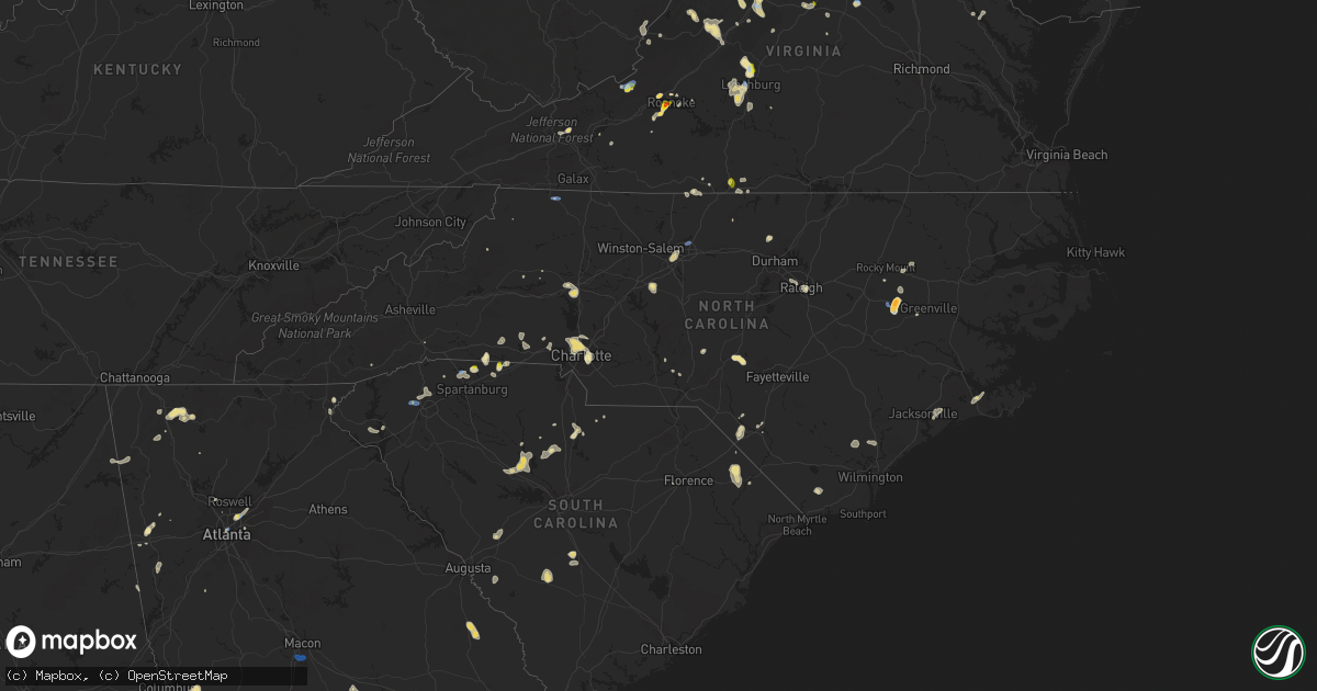
Hail Map in North Carolina on August 1, 2019
Get this storm
August 1 map
$229
one time, instant access
Download today. No call, no setup
Keep the $229
Bought the map and want the full workflow? Apply the entire $229 to a subscription within 7 days. None of it is wasted.
Every map, not just this one
This buys you this map. Subscription and you get every map we run, in the markets you choose from a few cities to whole states to nationwide. Plus real-time alerts the moment a storm fires.
Contact data
Name, contact info, occupancy, even credit band for addresses in the footprint. You go from where it hit to who to call.
Become the source they trust
Unlimited branding weather history reports on demand. You already have the documented answer ready for the property owner, and you are the one who showed up with it.
Property data and RoofTrace estimates
Pull up any address you have got, its value and the exact code rules for that jurisdiction, straight from One Click Code. Then RoofTrace estimates the squares, pitch, and roof value, priced the way you price.
Storm reports in North Carolina
North Carolina
| Date | Description |
|---|---|
| 08/01/20195:42 PM CDT | Report of golfball size hail from public... Confirmed by pictures of damage to tobacco crop. |
| 08/01/20195:37 PM CDT | Tree down in the 800 block of clarkway drive. Time estimated from radar. |
| 08/01/20195:36 PM CDT | Multiple trees downed and roofs damaged in the area. |
| 08/01/20195:34 PM CDT | Tree down near the fisher hill road overpass crossing north carolina route 14. |
| 08/01/20195:32 PM CDT | At least a couple of trees down in the area in addition to previously reported structure that collapsed with a tree on it. |
| 08/01/20195:32 PM CDT | Tree down across the road at the intersection of pine drive and furr road. |
| 08/01/20195:32 PM CDT | Tree on a house on west front street. |
| 08/01/20195:29 PM CDT | Tree down in the 14000 block of old state highway 87. |
| 08/01/20195:25 PM CDT | Tree down at furr rd and pine dr. |
| 08/01/20195:18 PM CDT | A few trees blown down near interstate 485 and hwy 115. |
| 08/01/20195:16 PM CDT | A few trees down along and near shamrock drive and kilborne park area. |
| 08/01/20195:14 PM CDT | Tree down on power lines at lakebay rd and youngs rd. |
| 08/01/20195:05 PM CDT | Several large branches blown down on ramah church rd near hwy 115. |
| 08/01/20194:30 PM CDT | Several mobile homes damaged by a possible downburst. Time approximated by radar. |
| 08/01/20193:20 PM CDT | Trees down and a roof blown off a barn at canton rd. And austin rd. |
| 08/01/20192:45 PM CDT | Thunderstorm winds downed a few trees across area roadways primarily in the southern portions of thomasville. Time estimated via radar. |
| 08/01/20192:36 PM CDT | Thunderstorm winds downed a tree along bryant road... Temporarily blocking it. |
| 08/01/20192:17 PM CDT | Thunderstorm winds downed several trees along friar tuck road... A few of which damaged powerlines and a fence. Time estimated via radar. |
| 08/01/20191:55 PM CDT | Two trees down on ward rd and patrick rd... Resulting in power outages. |
| 08/01/20191:48 PM CDT | Tree fell on utility equipment at e whitaker mill rd and wake forest rd... Resulting in power outages. |
| 08/01/20191:25 PM CDT | A few trees down in alleghany manor near the river. Time from radar. |
| 08/01/201912:35 PM CDT | Large tree limbs blown down across blue ridge road. Fire department called to clear debris. |
| 08/01/20197:55 AM CDT | At 1254 PM EDT, a severe thunderstorm was located 5 miles south of Foscoe, or near Grandfather Mountain State Park, and is nearly stationary. HAZARD...60 mph wind gusts and quarter size hail. SOURCE...Radar indicated. IMPACT...Minor hail damage to vehicles is expected. Expect wind damage to trees and power lines. Locations impacted include... Upton, Globe, Blowing Rock, Grandfather Mountain State Park and the B.R. Parkway between Linville Falls To Grandfather. |
| 08/01/20194:34 AM CDT | At 933 PM EDT, a severe thunderstorm was located near Flatwood, or 7 miles northeast of Mountain City, and is nearly stationary. HAZARD...60 mph wind gusts and quarter size hail. SOURCE...Radar indicated. IMPACT...Hail damage to vehicles is expected. Expect wind damage to roofs, siding, and trees. Locations impacted include... Mountain City and Laurel Bloomery. |
| 08/01/20193:44 AM CDT | At 844 PM EDT, a severe thunderstorm was located near High Point, moving north at 15 mph. HAZARD...60 mph wind gusts and nickel size hail. SOURCE...Radar indicated. IMPACT...Expect damage to roofs, siding, and trees. Locations impacted include... Greensboro, High Point, Kernersville, Pleasant Garden, Jamestown, Lake Townsend, Lake Jeanette Marina, Lake Brandt, Colfax and Oak Hollow Marina. |
| 08/01/20192:14 AM CDT | At 714 PM EDT, a severe thunderstorm was located near Statesville, moving north at 5 mph. HAZARD...60 mph wind gusts and quarter size hail. SOURCE...Radar indicated. IMPACT...Minor hail damage to vehicles is expected. Expect wind damage to trees and power lines. Locations impacted include... Statesville, Stony Point, Catawba, Lookout Shoals Lake, Hiddenite, Turnersburg, Scotts and Taylorsville. |
| 08/01/20191:39 AM CDT | At 639 PM EDT, a severe thunderstorm was located 8 miles west of Pope AFB, or 9 miles west of Fort Bragg, moving southeast at 10 mph. HAZARD...60 mph wind gusts. SOURCE...Radar indicated. IMPACT...Expect damage to roofs, siding, and trees. Locations impacted include... Fort Bragg, Pope AFB, Spring Lake and Vass. |
| 08/01/20191:28 AM CDT | At 628 PM EDT, a severe thunderstorm was located near Statesville, moving northeast at 10 mph. HAZARD...60 mph wind gusts and quarter size hail. SOURCE...Radar indicated. IMPACT...Minor hail damage to vehicles is expected. Expect wind damage to trees and power lines. Locations impacted include... Statesville, Troutman, Cleveland, Lake Norman State Park, Turnersburg, Cool Springs, Piedmont Research Station, Mount Ulla, Doolie and Lake Norman. |
| 08/01/20191:24 AM CDT | At 623 PM EDT, a severe thunderstorm was located 4 miles northwest of Uptown Charlotte, or over Northwest Charlotte, moving south at 10 mph. HAZARD...60 mph wind gusts and quarter size hail. SOURCE...Radar indicated. IMPACT...Minor hail damage to vehicles is expected. Expect wind damage to trees and power lines. Locations impacted include... Uptown Charlotte, Huntersville, Central Charlotte, Northeast Charlotte, Southwest Charlotte, East Charlotte, Northwest Charlotte, Mt Holly, Freedom Park and University City. |
| 08/01/20191:22 AM CDT | At 622 PM EDT, a severe thunderstorm was located near Farmville, moving south at 15 mph. HAZARD...60 mph wind gusts and quarter size hail. SOURCE...Radar indicated. IMPACT...Hail damage to vehicles is expected. Expect wind damage to roofs, siding, and trees. Locations impacted include... Farmville, Snow Hill, Ormondsville, Maury, Lizzie, Castoria, Fort Run VFD, Bull Head VFD and Walstonburg. |
| 08/01/20191:12 AM CDT | At 612 PM EDT, a severe thunderstorm was located 4 miles southeast of Uptown Charlotte, or near East Charlotte, moving northwest at 10 mph. HAZARD...60 mph wind gusts and quarter size hail. SOURCE...Radar indicated. IMPACT...Minor hail damage to vehicles is expected. Expect wind damage to trees and power lines. Locations impacted include... Uptown Charlotte, Central Charlotte, South Charlotte, East Charlotte, Northwest Charlotte, Matthews, Mint Hill, Freedom Park, University City and Reedy Creek Park. |
| 08/01/201912:53 AM CDT | At 553 PM EDT, a severe thunderstorm was located over Cascade, and is nearly stationary. HAZARD...60 mph wind gusts and half dollar size hail. SOURCE...Radar indicated. IMPACT...Hail damage to vehicles is expected. Expect wind damage to roofs, siding, and trees. Locations impacted include... Eden... Mayfield... Oregon Hill... Ruffin... and Draper. |
| 08/01/201912:51 AM CDT | At 551 PM EDT, a severe thunderstorm was located near Huntersville, or near Northeast Charlotte, and is nearly stationary. HAZARD...60 mph wind gusts. SOURCE...Radar indicated. IMPACT...Expect damage to trees and power lines. Locations impacted include... Huntersville, Northeast Charlotte, Croft and Northwest Charlotte. |
| 08/01/201912:17 AM CDT | At 516 PM EDT, a severe thunderstorm was located over Ringgold, moving east at 10 mph. HAZARD...60 mph wind gusts and quarter size hail. SOURCE...Radar indicated. IMPACT...Hail damage to vehicles is expected. Expect wind damage to roofs, siding, and trees. Locations impacted include... Danville... Blairs... Ingram... Callands... and Milton.This includes The following Location Danville Airport. |
| 08/01/201912:08 AM CDT | At 507 PM EDT, a severe thunderstorm was located 10 miles southeast of Forest City, or 4 miles north of Cowpens National Battlefield, moving northeast at 5 mph. HAZARD...60 mph wind gusts and quarter size hail. SOURCE...Radar indicated. IMPACT...Minor hail damage to vehicles is expected. Expect wind damage to trees and power lines. Locations impacted include... Cliffside, Henrietta, Cowpens National Battlefield and Caroleen. |
| 07/31/201911:53 PM CDT | At 453 PM EDT, a severe thunderstorm was located 8 miles southeast of Forest City, or near Mooresboro, moving northeast at 5 mph. HAZARD...60 mph wind gusts and quarter size hail. SOURCE...Radar indicated. IMPACT...Minor hail damage to vehicles is expected. Expect wind damage to trees and power lines. Locations impacted include... Boiling Springs NC, Ellenboro, Lattimore, Mooresboro, Cliffside, Henrietta and Caroleen. |
| 07/31/201911:50 PM CDT | At 450 PM EDT, a severe thunderstorm was located near Rougemont, or 11 miles northeast of Hillsborough, moving northeast at 15 mph. HAZARD...60 mph wind gusts and nickel size hail. SOURCE...Radar indicated. IMPACT...Expect damage to roofs, siding, and trees. Locations impacted include... Roxboro, Rougemont, Lake Michie, Moriah, Berea, Surl, Bahama, Schley and Lake Butner. |
| 07/31/201910:35 PM CDT | At 335 PM EDT, a severe thunderstorm was located 7 miles south of Thomasville, or 7 miles east of Lexington, moving north at 15 mph. HAZARD...60 mph wind gusts and nickel size hail. SOURCE...Radar indicated. IMPACT...Expect damage to roofs, siding, and trees. Locations impacted include... High Point, Lexington, Thomasville, Archdale, Trinity, Jamestown, Gordontown and Welcome. |
| 07/31/201910:17 PM CDT | At 317 PM EDT, a severe thunderstorm was located near Garner, or 7 miles southeast of Raleigh, moving south at 10 mph. HAZARD...60 mph wind gusts and quarter size hail. SOURCE...Radar indicated. IMPACT...Hail damage to vehicles is expected. Expect wind damage to roofs, siding, and trees. Locations impacted include... Raleigh, Cary, Garner, Fuquay-Varina, Clayton, Lake Wheeler and Lake Benson. |
| 07/31/20199:19 PM CDT | At 219 PM EDT, a severe thunderstorm was located over Glade Valley, and is nearly stationary. HAZARD...60 mph wind gusts and quarter size hail. SOURCE...Radar indicated. IMPACT...Hail damage to vehicles is expected. Expect wind damage to roofs, siding, and trees. Locations impacted include... Sparta... Roaring Gap... Glade Valley... Barrett... and Whitehead. |
| 07/31/20199:18 PM CDT | A few trees blown down near interstate 485 and hwy 115. |
| 07/31/20198:55 PM CDT | At 155 PM EDT, a severe thunderstorm was located near Hendersonville, or near Laurel Park, moving east at 10 mph. HAZARD...60 mph wind gusts and quarter size hail. SOURCE...Radar indicated. IMPACT...Minor hail damage to vehicles is expected. Expect wind damage to trees and power lines. Locations impacted include... Hendersonville, Flat Rock, Laurel Park, Valley Hill, East Flat Rock, Crab Creek, Horse Shoe and Dana. |
| 07/31/20198:23 PM CDT | At 123 PM EDT, a severe thunderstorm was located 12 miles southwest of Brevard, or near Lake Toxaway, and is nearly stationary. HAZARD...60 mph wind gusts and nickel size hail. SOURCE...Radar indicated. IMPACT...Expect damage to trees and power lines. Locations impacted include... Lake Toxaway, Sapphire and Gorges State Park. |
| 07/31/20198:07 PM CDT | Tree down at w florida st and s holden rd. |
All States Impacted by Hail Map on August 1, 2019
Cities Impacted by Hail Map on August 1, 2019
- Orangeburg, SC
- El Dorado, KS
- Forsyth, MT
- Akron, CO
- Sudlersville, MD
- Millington, MD
- Dallas, NC
- Gastonia, NC
- Bay Minette, AL
- Atlanta, GA
- Holly, CO
- Blacksburg, SC
- Inkom, ID
- Staunton, VA
- Marion, SC
- Mullins, SC
- Dillon, SC
- Fork, SC
- Brush, CO
- Waverly, AL
- Blackville, SC
- Denmark, SC
- Intercourse, PA
- Paradise, PA
- Kinzers, PA
- Ronks, PA
- Gordonville, PA
- Bird In Hand, PA
- Simpson, KS
- Beloit, KS
- Glasco, KS
- Waynesboro, GA
- Tampa, KS
- Brooklyn, MD
- Springerville, AZ
- Cuba, AL
- Lauderdale, MS
- Beulah, ND
- Stoneham, CO
- Atwood, CO
- Sterling, CO
- Merino, CO
- Seaford, DE
- Harrington, DE
- Georgetown, DE
- Laurel, DE
- Bridgeville, DE
- Greenwood, DE
- Mandaree, ND
- Killdeer, ND
- Hinton, WV
- Daniels, WV
- Shady Spring, WV
- Courtenay, ND
- Durham, KS
- Bremen, GA
- Buchanan, GA
- Roundup, MT
- Douglass, KS
- Severna Park, MD
- Crownsville, MD
- Millersville, MD
- Garrison, KY
- Olive Hill, KY
- Salem, AL
- Clermont, FL
- Grover, CO
- Carpenter, WY
- Pine Bluffs, WY
- Haswell, CO
- Eads, CO
- Fort Benning, GA
- Cusseta, GA
- Salem, VA
- Roanoke, VA
- Statesville, NC
- Kimball, NE
- Dix, NE
- Limon, CO
- Ramah, CO
- Matheson, CO
- Hugo, CO
- Lafayette, AL
- Jackson, OH
- Stuarts Draft, VA
- Mooresboro, NC
- Spotsylvania, VA
- Leon, KS
- Augusta, KS
- Peach Bottom, PA
- Kirkwood, PA
- Nottingham, PA
- Oxford, PA
- Quarryville, PA
- New Castle, VA
- Karval, CO
- Agate, CO
- Raleigh, NC
- Dothan, AL
- Headland, AL
- Hughesville, MD
- Charlotte Hall, MD
- Mechanicsville, MD
- Alliance, NE
- Cohagen, MT
- Pisgah, AL
- Henagar, AL
- Jewell, KS
- Formoso, KS
- Courtland, KS
- Jamestown, KS
- Norway, KS
- Carrollton, GA
- Roopville, GA
- Franklin, GA
- Troutman, NC
- Whitmire, SC
- Lexington, VA
- Garrison, ND
- Arkansas City, KS
- Winfield, KS
- Hemingford, NE
- Ider, AL
- Greensboro, NC
- Jamestown, NC
- Dazey, ND
- Otis, CO
- Curtis Bay, MD
- Pasadena, MD
- Halethorpe, MD
- Baltimore, MD
- Glen Burnie, MD
- Harrison, NE
- Stevens, PA
- Reinholds, PA
- Denver, PA
- Christiana, PA
- Smoketown, PA
- Terre Hill, PA
- Adamstown, PA
- East Earl, PA
- Mohnton, PA
- Ephrata, PA
- Leola, PA
- New Holland, PA
- Forest Hill, MD
- Bel Air, MD
- Arnegard, ND
- Craigsville, VA
- Greenville, VA
- Middlebrook, VA
- Swoope, VA
- Charlottesville, VA
- Axton, VA
- Ridgeway, VA
- Cascade, VA
- Boones Mill, VA
- Fayetteville, TN
- Kelso, TN
- Watford City, ND
- Vass, NC
- New Salem, ND
- Woodville, AL
- Scottsboro, AL
- Gaffney, SC
- Hope, KS
- Whiteford, MD
- Delta, PA
- Webster Springs, WV
- Mulberry, TN
- Winnsboro, SC
- Sanborn, ND
- Esbon, KS
- Havelock, NC
- Lynchburg, VA
- Evington, VA
- Taylors, SC
- Greenville, SC
- Travelers Rest, SC
- Ranburne, AL
- Heflin, AL
- Five Points, AL
- Towanda, KS
- Forest, VA
- Bighorn, MT
- Resaca, GA
- Hamer, SC
- Brockton, MT
- Waldorf, MD
- Brandywine, MD
- Bryantown, MD
- Aquasco, MD
- Florala, AL
- Andalusia, AL
- Angela, MT
- Sparta, NC
- Georgetown, GA
- Fort Gaines, GA
- Morris, GA
- Goshen, VA
- Ray, OH
- Londonderry, OH
- Chillicothe, OH
- Walstonburg, NC
- Farmville, NC
- Fountain, NC
- Stantonsburg, NC
- Rainelle, WV
- Millboro, VA
- Hillrose, CO
- Rowland, NC
- Derby, KS
- Lumberton, NC
- Lehigh, KS
- Rose Hill, KS
- Syracuse, KS
- Lexington, NC
- Thomasville, NC
- Pettibone, ND
- Fort Morgan, CO
- Henderson, MD
- Hartly, DE
- Houston, DE
- Marydel, DE
- Camden Wyoming, DE
- Marydel, MD
- Goldsboro, MD
- Barclay, MD
- Ellendale, DE
- Greensboro, MD
- Felton, DE
- Chesnee, SC
- Anderson, SC
- Malta, ID
- Hereford, CO
- Delmar, MD
- Delmar, DE
- Amherst, VA
- Madison Heights, VA
- Monroe, VA
- Rappahannock Academy, VA
- King George, VA
- Solomon, KS
- Wing, ND
- Bent Mountain, VA
- Newport, VA
- Copper Hill, VA
- Cartwright, ND
- Williston, ND
- Fairview, MT
- Armuchee, GA
- Calhoun, GA
- Sugar Valley, GA
- Roanoke, AL
- Blackfoot, ID
- Eden, NC
- Sugar Grove, WV
- Bainville, MT
- Prosperity, SC
- Pomaria, SC
- Alexander, ND
- Mankato, KS
- Troy, VA
- Raphine, VA
- Coolville, OH
- Guysville, OH
- Hysham, MT
- Sanders, MT
- Wyndmere, ND
- Newark, DE
- Mill Creek, WV
- Atlanta, KS
- Charlotte, NC
- Millen, GA
- Perkins, GA
- Columbus, ND
- Bidwell, OH
- Gallipolis, OH
- Forkland, AL
- Hazen, ND
- Ririe, ID
- Dunn Center, ND
- Marietta, GA
- Keene, ND
- Lewistown, MT
- Briggsdale, CO
- Yanceyville, NC
- Marion, KS
- Hillsboro, KS
- Waverly, OH
- Rockford, AL
- Delphos, KS
- Minneapolis, KS
- Dalton, GA
- Chatsworth, GA
- Zap, ND
- Shelby, NC
- Cherryville, NC
- Huntersville, NC
- Dallas, GA
- White Sulphur Springs, WV
- Roggen, CO
- Lebanon, KS
- Lanett, AL
- Kit Carson, CO
- Peterman, AL
- Monroeville, AL
- Homestead, MT
- Louisville, TN
- Knoxville, TN
- Newberry, SC
- Blair, SC
- Norway, SC
- McDavid, FL
- Beaver, OH
- Tarboro, NC
- Rocky Mount, NC
- Rockmart, GA
- Street, MD
- Honoraville, AL
- Greenville, AL
- Ash, NC
- Snyder, CO
- Louisa, VA
- Gordonsville, VA
- Goode, VA
- Burns, KS
- Potwin, KS
- Boligee, AL
- Minatare, NE
- Benedict, ND
- Crossville, TN
- Unionville, VA
- Orange, VA
- Oxford, KS
- Udall, KS
- Belle Plaine, KS
- Nichols, SC
- Athens, OH
- Stewart, OH
- Cutler, OH
- Little Hocking, OH
- Padroni, CO
- Halliday, ND
- Pinetta, FL
- Madison, FL
- Lincolnville, KS
- West End, NC
- Verona, VA
- Nashville, GA
- Harman, WV
- Lakemont, GA
- Musselshell, MT
- Aiken, SC
- Ridge Spring, SC
- Scenic, SD
- Massey, MD
- Clayton, DE
- Galena, MD
- Townsend, DE
- Lancaster, SC
- Jennings, FL
- Lake Park, GA
- Philip, SD
- Wytheville, VA
- Latta, SC
- Salina, KS
- Harrisburg, NE
- Rougemont, NC
- Bahama, NC
- Hillsborough, NC
- Virginia City, MT
- Century, FL
- Bayard, NE
- Milton, NC
- Ringgold, VA
- Darlington, MD
- Lyerly, GA
- New Raymer, CO
- Woodland, AL
- Waco, GA
- Show Low, AZ
- Lakeside, AZ
- Pinetop, AZ
- Shade, OH
- Tappahannock, VA
- Garner, NC
- Annapolis, MD
- Gap, PA
- Reading, PA
- Lancaster, PA
- Alton, VA
- Mobile, AL
- Lucedale, MS
- Wilmer, AL
- Brookwood, AL
- Middleport, OH
- Bristol, TN
- Bluff City, TN
- Kingsport, TN
- Byers, CO
- Boiling Springs, SC
- Rockbridge Baths, VA
- Covington, VA
- Newkirk, OK
- Kings Mountain, NC
- Lower Peach Tree, AL
- Semmes, AL
- Culbertson, MT
- Valley Center, KS
- Lambert, MT
- Fredericksburg, VA
- Stone Mountain, GA
- Pine Lake, GA
- Ellerbe, NC
- Blountsville, AL
- Clayton, GA
- West Columbia, WV
- Burgaw, NC
- Rocky Point, NC
- Vinton, VA
- Fishersville, VA
- Rosebud, MT
- Midland City, AL
- Callaway, VA
- Severn, MD
- Riva, MD
- Gambrills, MD
- Davidsonville, MD
- Decatur, AL
- Clarkrange, TN
- Auburn, AL
- Opelika, AL
- Ramona, KS
- Lima, MT
- Owings, MD
- Tracys Landing, MD
- Friendship, MD
- Sunderland, MD
- Dunkirk, MD
- Huntingtown, MD
- Lothian, MD
- Buffalo, WV
- Quitman, MS
- Dexter, GA
- Dudley, GA
- Great Falls, SC
- Blackstock, SC
- Fairmount, GA
- Midway Park, NC
- Hubert, NC
- Jacksonville, NC
- Maysville, NC
- Camp Lejeune, NC
- Senoia, GA
- Madison, AL
- Locust Grove, VA
- Epping, ND
- Lake Toxaway, NC
- Maxton, NC
- Pocatello, ID
- West Grove, PA
- Cochranville, PA
- Rustburg, VA
- Pembroke, NC
- Fairmont, NC
- Collettsville, NC
- Blowing Rock, NC
- Steele, ND
- Tuttle, ND
- Inman, SC
- Conowingo, MD
- Peabody, KS
- Timmonsville, SC
- Wiggins, CO
- Oak Hill, OH
- Smoot, WV
- Alapaha, GA
- Hiwassee, VA
- Keenesburg, CO
- Bennett, CO
- Adger, AL
- Rosedale, MD
- Loris, SC
- Easley, SC
- Newton, KS
- Mount Gilead, NC
- Gering, NE
- Port Royal, VA
- Bowbells, ND
- Benton, KS
- Wichita, KS
- Andover, KS
- Golden Valley, ND
- Doe Hill, VA
- Stafford, VA
- Talladega, AL
- Winterville, NC
- Greenville, NC
- Atmore, AL
- Danville, VA
- Anton, CO
- Lindon, CO
- Whitewater, KS
- Florence, KS
- Piketon, OH
- Payson, AZ
- Forest Grove, MT
- High Point, NC
- Mount Holly, NC
- Currie, NC
- Buena Vista, GA
- Box Springs, GA
- Crossville, AL
- Albertville, AL
- Geraldine, AL
- Abilene, KS
- Jackson Springs, NC
- Mineral, VA
- Loretto, VA
- Groveland, FL
- Lenox, GA
- Glendive, MT
- Bridgeport, NE
- Kenmare, ND
- Gaylesville, AL
- Big Timber, MT
- Heath Springs, SC
- Atkinson, NC
- Toomsuba, MS
- Chester, GA
- Seneca, SC
- Townville, SC
- Hudson, NC
- Granite Falls, NC
- Coolidge, KS
- Vance, AL
- Otway, OH
- Peebles, OH
- Deer Trail, CO
- Dover, DE
- Nottingham, MD
- Duluth, GA
- Norcross, GA
- Rocky Face, GA
- Wall, SD
- New Town, ND
- Randall, KS
- Valley City, ND
- Sutherlin, VA
- Richey, MT
- Mulvane, KS
- Willis, VA
- Lilesville, NC
- Meridian, MS
- Fraziers Bottom, WV
- Fort Lawn, SC
- Minford, OH
- Fairfield, VA
- Sidney, NE
- Fleetwood, NC
- Campobello, SC
- Addison, AL
- Ovett, MS
- Citronelle, AL
- Angora, NE
- Roseland, VA
- Clay Center, KS
- Elm City, NC
- Robinson, ND
- Douglas, ND
- Warsaw, VA
- Tazewell, TN
- Barnard, KS
- Tescott, KS
- Evergreen, AL
- Taylorsville, NC
- Concord, VA
- Rogers, ND
- Scottsville, VA
- Max, ND
- Richmond, VA
- Hendersonville, NC
- Livingston, MT
- Parsonsburg, MD
- Salisbury, MD
- Selden, KS
- Chester, SC
- Needham, AL
- Lamont, FL
- Macclesfield, NC
- Pinetops, NC
- Groveoak, AL
- Fyffe, AL
- Bethel, DE
- Macon, GA
- Cadwell, GA
- Piedmont, AL
- Glade Valley, NC
- Wilson, NC
- Blountville, TN


