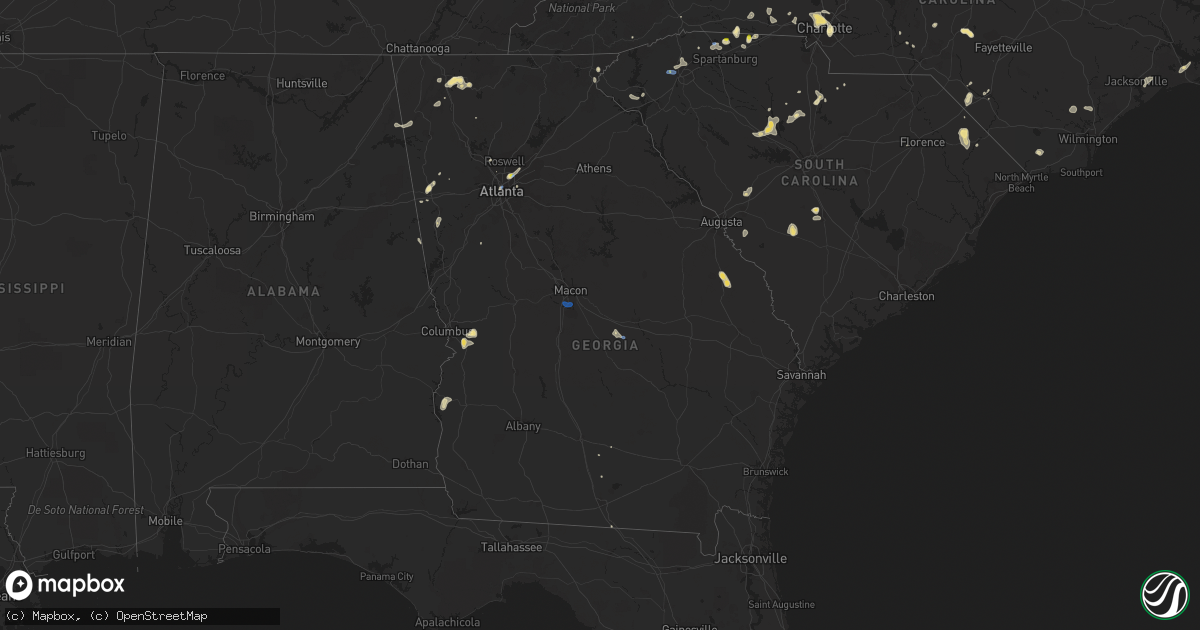
Hail Map in Georgia on August 1, 2019
Get this storm
August 1 map
$229
one time, instant access
Download today. No call, no setup
Keep the $229
Bought the map and want the full workflow? Apply the entire $229 to a subscription within 7 days. None of it is wasted.
Every map, not just this one
This buys you this map. Subscription and you get every map we run, in the markets you choose from a few cities to whole states to nationwide. Plus real-time alerts the moment a storm fires.
Contact data
Name, contact info, occupancy, even credit band for addresses in the footprint. You go from where it hit to who to call.
Become the source they trust
Unlimited branding weather history reports on demand. You already have the documented answer ready for the property owner, and you are the one who showed up with it.
Property data and RoofTrace estimates
Pull up any address you have got, its value and the exact code rules for that jurisdiction, straight from One Click Code. Then RoofTrace estimates the squares, pitch, and roof value, priced the way you price.
Storm reports in Georgia
Georgia
| Date | Description |
|---|---|
| 08/01/20195:45 PM CDT | Tree down in the road near the intersection of polly road ne and mitchell bridge rd in dalton ga. Time estimated from radar. |
| 08/01/20195:43 PM CDT | Tree reported down on the road near the intersection of guinn and mitchell bridge rd near dalton ga. Time estimated from radar. |
| 08/01/20195:41 PM CDT | A tree was reported down on the road near the intersection of underwood st and n bypass near dalton ga. Time estimated from radar. |
| 08/01/20195:12 PM CDT | Trees and powerlines reported down along old federal road and in fort mountain state park se of chatsworth. |
| 08/01/20194:44 PM CDT | A tree was reported as blocking the roadway near the intersection of e. Washington and university st. Near trion ga. Time estimated by radar. |
| 08/01/20194:42 PM CDT | A powerline was reported down across the 1000th block of wiggins rd near lyerly ga. Time estimated from radar. |
| 08/01/20194:42 PM CDT | A tree was reported down across the 100th block of poplar springs rd near summerville ga. Time estimated by radar. |
| 08/01/20194:30 PM CDT | Dozens of trees were blown down in the area of embry hills drive. Some were downed onto homes and power lines. |
| 08/01/20194:30 PM CDT | Quarter-sized hail fell at the i-85/i-285 interchange along with estimated 40-50 mph wind gusts. |
| 08/01/20194:30 PM CDT | A large tree was downed onto the onramp from i-285 to i-85. |
| 08/01/20194:24 PM CDT | Trees reported down causing vehicle damage near the intersection of embry court and embry hills drive in embry hills ga. |
| 08/01/20194:12 PM CDT | Trees and powerlines reported down near the intersection of 7th st and durant pi ne in midtown. |
| 08/01/20194:10 PM CDT | A tree fell across elkmont rd ne. |
| 08/01/20194:06 PM CDT | Macon asos |
| 08/01/20194:05 PM CDT | Macon asos |
| 08/01/20193:12 PM CDT | Powerlines and trees reported down near the intersection of east-west connector and hurt rd near austell ga. |
| 08/01/20192:50 PM CDT | Roof blown off of mobile home in the dexter area. |
| 08/01/20192:43 PM CDT | 12-20 trees down across a 5 sq. Mile area in buchanan. A couple of powerlines down... Too. Did not impact any homes. |
| 08/01/20192:15 PM CDT | Power line down on the 300th block of fischer rd in sharpsburg ga. |
| 08/01/20192:12 PM CDT | Several trees down on powerlines across cole lake road near monroe cole road... South of dallas. Report relayed from ema. Time estimated from radar. |
| 08/01/20192:10 PM CDT | At least one tree down near the intersection of hwy 54 and johnson rd |
| 08/01/20192:00 PM CDT | A tree was downed onto a power line on elders mill rd. |
| 08/01/20191:45 PM CDT | Multiple reports of trees down between hwy 221 and the intersection of fire tower road and milligan creek road. Report from ema. Time estimated from radar. |
| 08/01/20197:49 AM CDT | At 1248 PM EDT, a severe thunderstorm was located near Nunez, or near Swainsboro, moving north at 5 mph. HAZARD...60 mph wind gusts and quarter size hail. SOURCE...Radar indicated. IMPACT...Hail damage to vehicles is expected. Expect wind damage to roofs, siding, and trees. Locations impacted include... Swainsboro, Stillmore, Nunez and Lexsy. |
| 08/01/20191:55 AM CDT | At 655 PM EDT, a severe thunderstorm was located over Eelbeck/West Fort Benning, or 9 miles north of Cusseta, moving north at 20 mph. HAZARD...60 mph wind gusts and quarter size hail. SOURCE...Radar indicated. IMPACT...Hail damage to vehicles is expected. Expect wind damage to roofs, siding, and trees. Locations impacted include... Talbotton, Geneva, Box Springs, Marion Estates, Juniper, Eelbeck/West Fort Benning, Baughville, Olive Branch and Po Biddy Crossroads. |
| 08/01/20191:28 AM CDT | At 628 PM EDT, a severe thunderstorm was located over Dalton, moving north at 5 mph. HAZARD...60 mph wind gusts and quarter size hail. SOURCE...Radar indicated. IMPACT...Hail damage to vehicles is expected. Expect wind damage to roofs, siding, and trees. Locations impacted include... Dalton, Tunnel Hill, Rocky Face, Dawnville and Tilton. |
| 08/01/20191:06 AM CDT | At 605 PM EDT, a severe thunderstorm was located over Fort Mountain State Park, or near Chatsworth, moving north at 10 mph. HAZARD...60 mph wind gusts and quarter size hail. SOURCE...Radar indicated. IMPACT...Hail damage to vehicles is expected. Expect wind damage to roofs, siding, and trees. Locations impacted include... Chatsworth, Eton, Fort Mountain State Park and Ramhurst. |
| 08/01/201912:42 AM CDT | At 542 PM EDT, a severe thunderstorm was located over Lake Marvin, or 7 miles northwest of Calhoun, and is nearly stationary. HAZARD...60 mph wind gusts and quarter size hail. SOURCE...Radar indicated. IMPACT...Hail damage to vehicles is expected. Expect wind damage to roofs, siding, and trees. Locations impacted include... Resaca, Sugar Valley, Everett Springs, Lake Marvin, Oostanaula and Subligna. |
| 08/01/201912:21 AM CDT | At 521 PM EDT, a severe thunderstorm was located over Doraville, or 8 miles north of Decatur, moving northeast at 15 mph. HAZARD...60 mph wind gusts and quarter size hail. SOURCE...Radar indicated. IMPACT...Hail damage to vehicles is expected. Expect wind damage to roofs, siding, and trees. Locations impacted include... Sandy Springs, Roswell, Alpharetta, Dunwoody, Duluth, Chamblee, Norcross, Doraville, Clarkston, Berkeley Lake, Tucker, North Atlanta, North Decatur, North Druid Hills, Mechanicsville, Brookhaven and Scottdale. |
| 08/01/201912:11 AM CDT | At 511 PM EDT, a severe thunderstorm was located over Rutland, or 7 miles south of Macon, and is nearly stationary. HAZARD...60 mph wind gusts and quarter size hail. SOURCE...Radar indicated. IMPACT...Hail damage to vehicles is expected. Expect wind damage to roofs, siding, and trees. Locations impacted include... Macon, Cross Keys, Franklinton, Middle Georgia Regional Airport, Skipperton and Rutland. |
| 07/31/201911:54 PM CDT | At 454 PM EDT, a severe thunderstorm was located over Piedmont Park, or over Atlanta, moving north at 10 mph. HAZARD...60 mph wind gusts and quarter size hail. SOURCE...Radar indicated. IMPACT...Hail damage to vehicles is expected. Expect wind damage to roofs, siding, and trees. Locations impacted include... Atlanta, Decatur, North Atlanta, North Druid Hills, Midtown, Grant Park-Zoo Atlanta, Druid Hills, North Decatur, Candler-Mcafee, Sweet Auburn, Piedmont Park, Brookhaven, East Lake, Little Five Points, Atlantic Station, West End, Virginia Highland, Turner Field, Kirkwood and Bankhead. |
| 07/31/201911:07 PM CDT | At 406 PM EDT, a severe thunderstorm was located over Sandy Plains, or near Marietta, moving north at 10 mph. HAZARD...60 mph wind gusts and quarter size hail. SOURCE...Radar indicated. IMPACT...Hail damage to vehicles is expected. Expect wind damage to roofs, siding, and trees. Locations impacted include... Marietta, Kennesaw, Acworth, Fair Oaks, Mount Bethel, White Water Park, Sweat Mountain, Sandy Plains and Kennesaw State University. |
| 07/31/201910:09 PM CDT | At 308 PM EDT, a severe thunderstorm was located near Dexter, or 13 miles southwest of Dublin, moving east at 10 mph. HAZARD...60 mph wind gusts and quarter size hail. SOURCE...Radar indicated. IMPACT...Hail damage to vehicles is expected. Expect wind damage to roofs, siding, and trees. Locations impacted include... Dublin, East Dublin, Dexter, Dudley, Rentz and Harlow. |
| 07/31/20199:59 PM CDT | At 259 PM EDT, a severe thunderstorm was located over Senoia, or 11 miles southwest of Fayetteville, moving north at 10 mph. HAZARD...60 mph wind gusts and quarter size hail. SOURCE...Radar indicated. IMPACT...Hail damage to vehicles is expected. Expect wind damage to roofs, siding, and trees. Locations impacted include... Peachtree City, Senoia, Brooks, Sharpsburg, Turin, Haralson and Starrs Mill. |
| 07/31/20197:34 PM CDT | Tree reported down on the road near the intersection of guinn and mitchell bridge rd near dalton ga. Time estimated from radar. |
| 07/31/20197:30 PM CDT | Tree down in the road near the intersection of polly road ne and mitchell bridge rd in dalton ga. Time estimated from radar. |
All States Impacted by Hail Map on August 1, 2019
Cities Impacted by Hail Map on August 1, 2019
- Orangeburg, SC
- El Dorado, KS
- Forsyth, MT
- Akron, CO
- Sudlersville, MD
- Millington, MD
- Dallas, NC
- Gastonia, NC
- Bay Minette, AL
- Atlanta, GA
- Holly, CO
- Blacksburg, SC
- Inkom, ID
- Staunton, VA
- Marion, SC
- Mullins, SC
- Dillon, SC
- Fork, SC
- Brush, CO
- Waverly, AL
- Blackville, SC
- Denmark, SC
- Intercourse, PA
- Paradise, PA
- Kinzers, PA
- Ronks, PA
- Gordonville, PA
- Bird In Hand, PA
- Simpson, KS
- Beloit, KS
- Glasco, KS
- Waynesboro, GA
- Tampa, KS
- Brooklyn, MD
- Springerville, AZ
- Cuba, AL
- Lauderdale, MS
- Beulah, ND
- Stoneham, CO
- Atwood, CO
- Sterling, CO
- Merino, CO
- Seaford, DE
- Harrington, DE
- Georgetown, DE
- Laurel, DE
- Bridgeville, DE
- Greenwood, DE
- Mandaree, ND
- Killdeer, ND
- Hinton, WV
- Daniels, WV
- Shady Spring, WV
- Courtenay, ND
- Durham, KS
- Bremen, GA
- Buchanan, GA
- Roundup, MT
- Douglass, KS
- Severna Park, MD
- Crownsville, MD
- Millersville, MD
- Garrison, KY
- Olive Hill, KY
- Salem, AL
- Clermont, FL
- Grover, CO
- Carpenter, WY
- Pine Bluffs, WY
- Haswell, CO
- Eads, CO
- Fort Benning, GA
- Cusseta, GA
- Salem, VA
- Roanoke, VA
- Statesville, NC
- Kimball, NE
- Dix, NE
- Limon, CO
- Ramah, CO
- Matheson, CO
- Hugo, CO
- Lafayette, AL
- Jackson, OH
- Stuarts Draft, VA
- Mooresboro, NC
- Spotsylvania, VA
- Leon, KS
- Augusta, KS
- Peach Bottom, PA
- Kirkwood, PA
- Nottingham, PA
- Oxford, PA
- Quarryville, PA
- New Castle, VA
- Karval, CO
- Agate, CO
- Raleigh, NC
- Dothan, AL
- Headland, AL
- Hughesville, MD
- Charlotte Hall, MD
- Mechanicsville, MD
- Alliance, NE
- Cohagen, MT
- Pisgah, AL
- Henagar, AL
- Jewell, KS
- Formoso, KS
- Courtland, KS
- Jamestown, KS
- Norway, KS
- Carrollton, GA
- Roopville, GA
- Franklin, GA
- Troutman, NC
- Whitmire, SC
- Lexington, VA
- Garrison, ND
- Arkansas City, KS
- Winfield, KS
- Hemingford, NE
- Ider, AL
- Greensboro, NC
- Jamestown, NC
- Dazey, ND
- Otis, CO
- Curtis Bay, MD
- Pasadena, MD
- Halethorpe, MD
- Baltimore, MD
- Glen Burnie, MD
- Harrison, NE
- Stevens, PA
- Reinholds, PA
- Denver, PA
- Christiana, PA
- Smoketown, PA
- Terre Hill, PA
- Adamstown, PA
- East Earl, PA
- Mohnton, PA
- Ephrata, PA
- Leola, PA
- New Holland, PA
- Forest Hill, MD
- Bel Air, MD
- Arnegard, ND
- Craigsville, VA
- Greenville, VA
- Middlebrook, VA
- Swoope, VA
- Charlottesville, VA
- Axton, VA
- Ridgeway, VA
- Cascade, VA
- Boones Mill, VA
- Fayetteville, TN
- Kelso, TN
- Watford City, ND
- Vass, NC
- New Salem, ND
- Woodville, AL
- Scottsboro, AL
- Gaffney, SC
- Hope, KS
- Whiteford, MD
- Delta, PA
- Webster Springs, WV
- Mulberry, TN
- Winnsboro, SC
- Sanborn, ND
- Esbon, KS
- Havelock, NC
- Lynchburg, VA
- Evington, VA
- Taylors, SC
- Greenville, SC
- Travelers Rest, SC
- Ranburne, AL
- Heflin, AL
- Five Points, AL
- Towanda, KS
- Forest, VA
- Bighorn, MT
- Resaca, GA
- Hamer, SC
- Brockton, MT
- Waldorf, MD
- Brandywine, MD
- Bryantown, MD
- Aquasco, MD
- Florala, AL
- Andalusia, AL
- Angela, MT
- Sparta, NC
- Georgetown, GA
- Fort Gaines, GA
- Morris, GA
- Goshen, VA
- Ray, OH
- Londonderry, OH
- Chillicothe, OH
- Walstonburg, NC
- Farmville, NC
- Fountain, NC
- Stantonsburg, NC
- Rainelle, WV
- Millboro, VA
- Hillrose, CO
- Rowland, NC
- Derby, KS
- Lumberton, NC
- Lehigh, KS
- Rose Hill, KS
- Syracuse, KS
- Lexington, NC
- Thomasville, NC
- Pettibone, ND
- Fort Morgan, CO
- Henderson, MD
- Hartly, DE
- Houston, DE
- Marydel, DE
- Camden Wyoming, DE
- Marydel, MD
- Goldsboro, MD
- Barclay, MD
- Ellendale, DE
- Greensboro, MD
- Felton, DE
- Chesnee, SC
- Anderson, SC
- Malta, ID
- Hereford, CO
- Delmar, MD
- Delmar, DE
- Amherst, VA
- Madison Heights, VA
- Monroe, VA
- Rappahannock Academy, VA
- King George, VA
- Solomon, KS
- Wing, ND
- Bent Mountain, VA
- Newport, VA
- Copper Hill, VA
- Cartwright, ND
- Williston, ND
- Fairview, MT
- Armuchee, GA
- Calhoun, GA
- Sugar Valley, GA
- Roanoke, AL
- Blackfoot, ID
- Eden, NC
- Sugar Grove, WV
- Bainville, MT
- Prosperity, SC
- Pomaria, SC
- Alexander, ND
- Mankato, KS
- Troy, VA
- Raphine, VA
- Coolville, OH
- Guysville, OH
- Hysham, MT
- Sanders, MT
- Wyndmere, ND
- Newark, DE
- Mill Creek, WV
- Atlanta, KS
- Charlotte, NC
- Millen, GA
- Perkins, GA
- Columbus, ND
- Bidwell, OH
- Gallipolis, OH
- Forkland, AL
- Hazen, ND
- Ririe, ID
- Dunn Center, ND
- Marietta, GA
- Keene, ND
- Lewistown, MT
- Briggsdale, CO
- Yanceyville, NC
- Marion, KS
- Hillsboro, KS
- Waverly, OH
- Rockford, AL
- Delphos, KS
- Minneapolis, KS
- Dalton, GA
- Chatsworth, GA
- Zap, ND
- Shelby, NC
- Cherryville, NC
- Huntersville, NC
- Dallas, GA
- White Sulphur Springs, WV
- Roggen, CO
- Lebanon, KS
- Lanett, AL
- Kit Carson, CO
- Peterman, AL
- Monroeville, AL
- Homestead, MT
- Louisville, TN
- Knoxville, TN
- Newberry, SC
- Blair, SC
- Norway, SC
- McDavid, FL
- Beaver, OH
- Tarboro, NC
- Rocky Mount, NC
- Rockmart, GA
- Street, MD
- Honoraville, AL
- Greenville, AL
- Ash, NC
- Snyder, CO
- Louisa, VA
- Gordonsville, VA
- Goode, VA
- Burns, KS
- Potwin, KS
- Boligee, AL
- Minatare, NE
- Benedict, ND
- Crossville, TN
- Unionville, VA
- Orange, VA
- Oxford, KS
- Udall, KS
- Belle Plaine, KS
- Nichols, SC
- Athens, OH
- Stewart, OH
- Cutler, OH
- Little Hocking, OH
- Padroni, CO
- Halliday, ND
- Pinetta, FL
- Madison, FL
- Lincolnville, KS
- West End, NC
- Verona, VA
- Nashville, GA
- Harman, WV
- Lakemont, GA
- Musselshell, MT
- Aiken, SC
- Ridge Spring, SC
- Scenic, SD
- Massey, MD
- Clayton, DE
- Galena, MD
- Townsend, DE
- Lancaster, SC
- Jennings, FL
- Lake Park, GA
- Philip, SD
- Wytheville, VA
- Latta, SC
- Salina, KS
- Harrisburg, NE
- Rougemont, NC
- Bahama, NC
- Hillsborough, NC
- Virginia City, MT
- Century, FL
- Bayard, NE
- Milton, NC
- Ringgold, VA
- Darlington, MD
- Lyerly, GA
- New Raymer, CO
- Woodland, AL
- Waco, GA
- Show Low, AZ
- Lakeside, AZ
- Pinetop, AZ
- Shade, OH
- Tappahannock, VA
- Garner, NC
- Annapolis, MD
- Gap, PA
- Reading, PA
- Lancaster, PA
- Alton, VA
- Mobile, AL
- Lucedale, MS
- Wilmer, AL
- Brookwood, AL
- Middleport, OH
- Bristol, TN
- Bluff City, TN
- Kingsport, TN
- Byers, CO
- Boiling Springs, SC
- Rockbridge Baths, VA
- Covington, VA
- Newkirk, OK
- Kings Mountain, NC
- Lower Peach Tree, AL
- Semmes, AL
- Culbertson, MT
- Valley Center, KS
- Lambert, MT
- Fredericksburg, VA
- Stone Mountain, GA
- Pine Lake, GA
- Ellerbe, NC
- Blountsville, AL
- Clayton, GA
- West Columbia, WV
- Burgaw, NC
- Rocky Point, NC
- Vinton, VA
- Fishersville, VA
- Rosebud, MT
- Midland City, AL
- Callaway, VA
- Severn, MD
- Riva, MD
- Gambrills, MD
- Davidsonville, MD
- Decatur, AL
- Clarkrange, TN
- Auburn, AL
- Opelika, AL
- Ramona, KS
- Lima, MT
- Owings, MD
- Tracys Landing, MD
- Friendship, MD
- Sunderland, MD
- Dunkirk, MD
- Huntingtown, MD
- Lothian, MD
- Buffalo, WV
- Quitman, MS
- Dexter, GA
- Dudley, GA
- Great Falls, SC
- Blackstock, SC
- Fairmount, GA
- Midway Park, NC
- Hubert, NC
- Jacksonville, NC
- Maysville, NC
- Camp Lejeune, NC
- Senoia, GA
- Madison, AL
- Locust Grove, VA
- Epping, ND
- Lake Toxaway, NC
- Maxton, NC
- Pocatello, ID
- West Grove, PA
- Cochranville, PA
- Rustburg, VA
- Pembroke, NC
- Fairmont, NC
- Collettsville, NC
- Blowing Rock, NC
- Steele, ND
- Tuttle, ND
- Inman, SC
- Conowingo, MD
- Peabody, KS
- Timmonsville, SC
- Wiggins, CO
- Oak Hill, OH
- Smoot, WV
- Alapaha, GA
- Hiwassee, VA
- Keenesburg, CO
- Bennett, CO
- Adger, AL
- Rosedale, MD
- Loris, SC
- Easley, SC
- Newton, KS
- Mount Gilead, NC
- Gering, NE
- Port Royal, VA
- Bowbells, ND
- Benton, KS
- Wichita, KS
- Andover, KS
- Golden Valley, ND
- Doe Hill, VA
- Stafford, VA
- Talladega, AL
- Winterville, NC
- Greenville, NC
- Atmore, AL
- Danville, VA
- Anton, CO
- Lindon, CO
- Whitewater, KS
- Florence, KS
- Piketon, OH
- Payson, AZ
- Forest Grove, MT
- High Point, NC
- Mount Holly, NC
- Currie, NC
- Buena Vista, GA
- Box Springs, GA
- Crossville, AL
- Albertville, AL
- Geraldine, AL
- Abilene, KS
- Jackson Springs, NC
- Mineral, VA
- Loretto, VA
- Groveland, FL
- Lenox, GA
- Glendive, MT
- Bridgeport, NE
- Kenmare, ND
- Gaylesville, AL
- Big Timber, MT
- Heath Springs, SC
- Atkinson, NC
- Toomsuba, MS
- Chester, GA
- Seneca, SC
- Townville, SC
- Hudson, NC
- Granite Falls, NC
- Coolidge, KS
- Vance, AL
- Otway, OH
- Peebles, OH
- Deer Trail, CO
- Dover, DE
- Nottingham, MD
- Duluth, GA
- Norcross, GA
- Rocky Face, GA
- Wall, SD
- New Town, ND
- Randall, KS
- Valley City, ND
- Sutherlin, VA
- Richey, MT
- Mulvane, KS
- Willis, VA
- Lilesville, NC
- Meridian, MS
- Fraziers Bottom, WV
- Fort Lawn, SC
- Minford, OH
- Fairfield, VA
- Sidney, NE
- Fleetwood, NC
- Campobello, SC
- Addison, AL
- Ovett, MS
- Citronelle, AL
- Angora, NE
- Roseland, VA
- Clay Center, KS
- Elm City, NC
- Robinson, ND
- Douglas, ND
- Warsaw, VA
- Tazewell, TN
- Barnard, KS
- Tescott, KS
- Evergreen, AL
- Taylorsville, NC
- Concord, VA
- Rogers, ND
- Scottsville, VA
- Max, ND
- Richmond, VA
- Hendersonville, NC
- Livingston, MT
- Parsonsburg, MD
- Salisbury, MD
- Selden, KS
- Chester, SC
- Needham, AL
- Lamont, FL
- Macclesfield, NC
- Pinetops, NC
- Groveoak, AL
- Fyffe, AL
- Bethel, DE
- Macon, GA
- Cadwell, GA
- Piedmont, AL
- Glade Valley, NC
- Wilson, NC
- Blountville, TN


