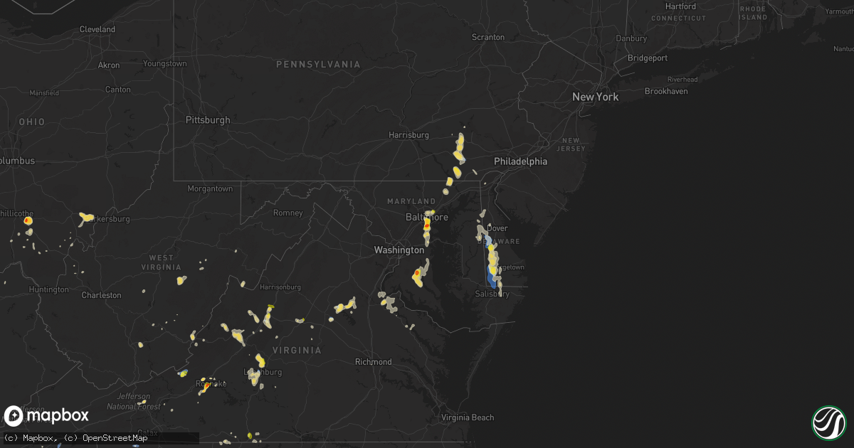
Hail Map on August 1, 2019
Get this storm
August 1 map
$229
one time, instant access
Download today. No call, no setup
Keep the $229
Bought the map and want the full workflow? Apply the entire $229 to a subscription within 7 days. None of it is wasted.
Every map, not just this one
This buys you this map. Subscription and you get every map we run, in the markets you choose from a few cities to whole states to nationwide. Plus real-time alerts the moment a storm fires.
Contact data
Name, contact info, occupancy, even credit band for addresses in the footprint. You go from where it hit to who to call.
Become the source they trust
Unlimited branding weather history reports on demand. You already have the documented answer ready for the property owner, and you are the one who showed up with it.
Property data and RoofTrace estimates
Pull up any address you have got, its value and the exact code rules for that jurisdiction, straight from One Click Code. Then RoofTrace estimates the squares, pitch, and roof value, priced the way you price.
States Impacted by Hail Map on August 1, 2019
Storm reports
Tennessee
| Date | Description |
|---|---|
| 08/01/20196:35 PM CDT | A few trees down. |
| 08/01/20196:35 PM CDT | Tree down on midland dr. |
| 08/01/20195:55 PM CDT | A few trees down near the englewood area. |
| 08/01/20194:30 PM CDT | A local report indicates 1.00 inch wind near 4 SW BEARDEN |
| 08/01/20192:04 PM CDT | *** 1 fatal *** a thunderstorm producing heavy rainfall and gusty winds caused a tree to fall on a vehicle on the spur between pigeon forge and gatlinburg resulting in |
| 08/01/20191:42 AM CDT | At 642 PM EDT, a severe thunderstorm was located near Athens, moving southwest at 10 mph. HAZARD...60 mph wind gusts and quarter size hail. SOURCE...Radar indicated. IMPACT...Hail damage to vehicles is expected. Expect wind damage to roofs, siding, and trees. Locations impacted include... Athens, Madisonville, Etowah, Englewood, Niota, Riceville, Mount Vernon and Dentville. |
| 08/01/201912:37 AM CDT | At 536 PM EDT, a severe thunderstorm was located near Louisville, or near Knoxville, and is nearly stationary. HAZARD...60 mph wind gusts and quarter size hail. SOURCE...Radar indicated. IMPACT...Hail damage to vehicles is expected. Expect wind damage to roofs, siding, and trees. Locations impacted include... Knoxville, Maryville, Alcoa, Farragut, Louisville, Rockford, Eagleton Village, Lake Forest, Bearden and Seymour. |
| 07/31/20198:50 PM CDT | Several trees down around the laurel bloomery area. |
| 07/31/20198:40 PM CDT | Carport blown into egypt rd. |
| 07/31/20198:15 PM CDT | Awning damage to condos at bristol motor speedway. |
| 07/31/20198:03 PM CDT | Tree down on avoca rd. |
| 07/31/20197:40 PM CDT | Large tree down in downtown bristol. |
Pennsylvania
| Date | Description |
|---|---|
| 08/01/20193:08 PM CDT | Tree down and blocking the road. Time estimated from radar. |
| 08/01/20192:10 PM CDT | Trees and wires down on bellemont rd |
| 08/01/20192:05 PM CDT | Trees and wires down on keneagy hill rd |
| 07/31/201910:13 PM CDT | At 312 PM EDT, a severe thunderstorm was located over Gap, moving southeast at 15 mph. HAZARD...60 mph wind gusts and quarter size hail. SOURCE...Radar indicated. IMPACT...Hail damage to vehicles is expected. Expect wind damage to trees, roofs, and siding. Locations impacted include... New Holland, Paradise, Strasburg, Quarryville, Gap, Wakefield, Smithville, Intercourse, Christiana, Blue Ball, Georgetown, Gordonville, Bird-In-Hand, Kirkwood, Little Britain, Refton, Buck, White Horse and Rawlinsville. |
| 07/31/20199:32 PM CDT | At 232 PM EDT, a severe thunderstorm was located over Terre Hill, moving south at 10 mph. HAZARD...60 mph wind gusts and quarter size hail. SOURCE...Radar indicated. IMPACT...Hail damage to vehicles is expected. Expect wind damage to trees, roofs, and siding. Locations impacted include... Ephrata, New Holland, Akron, Leola, Paradise, Reamstown, Strasburg, Gap, Adamstown, Terre Hill, Churchtown, Leacock, Bareville, Bowmansville, Lampeter, Intercourse, Fivepointville, Blue Ball, Farmersville and Gordonville.This includes The Pennsylvania Turnpike from mile markers 285 to 295. |
Virginia
| Date | Description |
|---|---|
| 08/01/20196:59 PM CDT | Trees down along high peak rd. Time estimated by radar. |
| 08/01/20196:56 PM CDT | Trees down along cedar gate rd. Time estimated by radar. |
| 08/01/20196:36 PM CDT | Multiple large branches down in the 300 block of summit street. |
| 08/01/20196:27 PM CDT | Tree blocking both lanes of meeks road near the virginia/north carolina state line. |
| 08/01/20196:19 PM CDT | One large limb blown down along u.s. 60. |
| 08/01/20196:08 PM CDT | One large limb down. |
| 08/01/20195:27 PM CDT | Corrects previous tstm wnd dmg report from 6 sw aiken summit. Tree blocking both lanes of meeks road near the virginia/north carolina state line. |
| 08/01/20195:05 PM CDT | Multiple reports of trees and wires down along us-340 stuarts draft highway. |
| 08/01/20195:04 PM CDT | Multiple trees down in the stuarts draft area. |
| 08/01/20194:36 PM CDT | Up to quarter size hail on barterbrook road. |
| 08/01/20194:35 PM CDT | A local report indicates 1.00 inch wind near 3 NNW RINGGOLD |
| 08/01/20194:20 PM CDT | Numerous large limbs down blocking roads in the city of staunton. |
| 08/01/20194:08 PM CDT | A few trees down near the intersection of cumberland gap road and mountain side drive. Time estimated from radar. |
| 08/01/20194:03 PM CDT | Tree down blocking one lane on johns creek mountain road. Time estimated from radar. |
| 08/01/20194:00 PM CDT | A couple of trees down. Time estimated from radar. |
| 08/01/20194:00 PM CDT | Large tree limbs downed onto power lines at west crawford st and fendall ave. |
| 08/01/20193:48 PM CDT | Close to a dozen trees and other debris down along the length of cumberland gap road south of simmonsville. One tree blocking both lanes of traffic in the 5700 block. T |
| 08/01/20193:35 PM CDT | Tree down on lizzie gunn rd. Time estimated by radar. |
| 08/01/20193:06 PM CDT | Corrects previous tstm wnd dmg report from 2 n indian valley. Tree down on duncan valley road. Time estimated from radar. |
| 08/01/20193:03 PM CDT | Tree down at the intersection of indian creek road and indian valley road. Time estimated from radar. |
| 08/01/20192:37 PM CDT | A local report indicates 1.00 inch wind near 2 E SALEM CITY |
| 08/01/20192:35 PM CDT | A local report indicates 1.75 inch wind near 2 NE CAVE SPRING |
| 08/01/20192:35 PM CDT | A local report indicates 1.25 inch wind near 1 SW ROANOKE |
| 08/01/20192:35 PM CDT | Quarter to golf ball size hail reported in southwest roanoke. |
| 08/01/20192:30 PM CDT | Quarter size hail reported at raleigh court. |
| 08/01/20192:28 PM CDT | Hail up to half dollar size at cave spring post office. |
| 08/01/20192:20 PM CDT | A local report indicates 1.00 inch wind near 1 NW CAVE SPRING |
| 08/01/20195:37 AM CDT | At 1037 PM EDT, a severe thunderstorm was located near Charlottesville, and is nearly stationary. HAZARD...60 mph wind gusts and quarter size hail. SOURCE...Radar indicated. IMPACT...Damaging winds will cause some trees and large branches to fall. This could injure those outdoors, as well as damage homes and vehicles. Roadways may become blocked by downed trees. Localized power outages are possible. Unsecured light objects may become projectiles. Locations impacted include... Charlottesville, Crozet, Westmoreland, Ivy, Overton, Newcomb Hall, Scott Stadium, Monticello, Flordon, Carrsbrook, Barracks and White Hall. |
| 08/01/20194:38 AM CDT | At 938 PM EDT, a severe thunderstorm was located 9 miles southeast of Orange, moving south at 10 mph. HAZARD...60 mph wind gusts and quarter size hail. SOURCE...Radar indicated. IMPACT...Damaging winds will cause some trees and large branches to fall. This could injure those outdoors, as well as damage homes and vehicles. Roadways may become blocked by downed trees. Localized power outages are possible. Unsecured light objects may become projectiles. Locations impacted include... Thornhill, Verdiersville, Unionville, Rhoadesville and Lahore. |
| 08/01/20194:14 AM CDT | At 914 PM EDT, a severe thunderstorm was located near Timberlake, moving southeast at 10 mph. HAZARD...60 mph wind gusts and quarter size hail. SOURCE...Radar indicated. IMPACT...Hail damage to vehicles is expected. Expect wind damage to roofs, siding, and trees. Locations impacted include... Altavista... Brookneal... Rustburg... Evington... and Concord.This includes The following Location Lynchburg Airport. |
| 08/01/20194:02 AM CDT | At 902 PM EDT, a severe thunderstorm was located near Louisa, and is nearly stationary. HAZARD...60 mph wind gusts and quarter size hail. SOURCE...Radar indicated. IMPACT...Minor damage to vehicles is possible. Expect wind damage to trees and powerlines. This severe thunderstorm will be near, Louisa and Mineral around 945 PM EDT.Other locations impacted by this severe thunderstorm includePendleton, Louisa Airport, Green Springs, Byrd Mill, Trevilians,Vawter Corner and Cuckoo. |
| 08/01/20193:57 AM CDT | At 857 PM EDT, a severe thunderstorm was located 12 miles west of Spotsylvania, or 14 miles north of Mineral, and is nearly stationary. HAZARD...60 mph wind gusts and quarter size hail. SOURCE...Radar indicated. IMPACT...Damaging winds will cause some trees and large branches to fall. This could injure those outdoors, as well as damage homes and vehicles. Roadways may become blocked by downed trees. Localized power outages are possible. Unsecured light objects may become projectiles. Locations impacted include... Spotsylvania, Mine Run, Rhoadesville, Brokenburg, Parker, Everona, Verdiersville, Alsop, Gold Dale, Nasons, Logan, Lahore and Unionville. |
| 08/01/20193:47 AM CDT | At 847 PM EDT, a severe thunderstorm was located near Charlottesville, and is nearly stationary. HAZARD...60 mph wind gusts. SOURCE...Radar indicated. IMPACT...Damaging winds will cause some trees and large branches to fall. This could injure those outdoors, as well as damage homes and vehicles. Roadways may become blocked by downed trees. Localized power outages are possible. Unsecured light objects may become projectiles. Locations impacted include... Charlottesville, Westmoreland, Hollymead, Ivy, Overton, Newcomb Hall, Scott Stadium, Monticello, Flordon, Carrsbrook, Shadwell and Barracks. |
| 08/01/20192:44 AM CDT | At 744 PM EDT, a severe thunderstorm was located over Buena Vista, moving south at 5 mph. HAZARD...60 mph wind gusts and quarter size hail. SOURCE...Radar indicated. IMPACT...Hail damage to vehicles is expected. Expect wind damage to roofs, siding, and trees. Locations impacted include... Lynchburg... Buena Vista... Glasgow... Big Island... and Forest. |
| 08/01/20192:06 AM CDT | At 706 PM EDT, a severe thunderstorm was located 7 miles west of Rockbridge Baths, moving south at 10 mph. HAZARD...60 mph wind gusts and quarter size hail. SOURCE...Radar indicated. IMPACT...Hail damage to vehicles is expected. Expect wind damage to roofs, siding, and trees. Locations impacted include... Lexington... and Collierstown.This includes The following Location VMI. |
| 08/01/20192:05 AM CDT | At 704 PM EDT, a severe thunderstorm was located near Kingsport, moving southwest at 10 mph. HAZARD...60 mph wind gusts and quarter size hail. SOURCE...Radar indicated. IMPACT...Hail damage to vehicles is expected. Expect wind damage to roofs, siding, and trees. Locations impacted include... Kingsport, Bristol Tn, Weber City, Colonial Heights, Spurgeon, Church Hill, Mount Carmel, Tri-City Airport, Blountville, Bays Mountain Park, Sullivan Gardens, Warriors Path State Park and Bloomingdale. |
| 08/01/20191:25 AM CDT | At 624 PM EDT, a severe thunderstorm was located over Rockbridge Baths, and is nearly stationary. HAZARD...60 mph wind gusts and quarter size hail. SOURCE...Radar indicated. IMPACT...Hail damage to vehicles is expected. Expect wind damage to roofs, siding, and trees. Locations impacted include... Rockbridge Baths... Fairfield... Brownsburg... and Vesuvius. |
| 08/01/20191:03 AM CDT | At 602 PM EDT, a severe thunderstorm was located over Stuarts Draft, or 9 miles southwest of Waynesboro, moving southeast at 10 mph. HAZARD...60 mph wind gusts. SOURCE...Radar indicated. IMPACT...Damaging winds will cause some trees and large branches to fall. This could injure those outdoors, as well as damage homes and vehicles. Roadways may become blocked by downed trees. Localized power outages are possible. Unsecured light objects may become projectiles. Locations impacted include... Stuarts Draft, Sherando, Wintergreen, Lyndhurst, Nellysford and Greenville. |
| 08/01/201912:44 AM CDT | At 544 PM EDT, a severe thunderstorm was located near Alvon, moving southeast at 10 mph. HAZARD...60 mph wind gusts and quarter size hail. SOURCE...Radar indicated. IMPACT...Hail damage to vehicles is expected. Expect wind damage to roofs, siding, and trees. Locations impacted include... Alleghany... Covington... Clifton Forge... White Sulphur Springs... and Neola. |
| 08/01/201912:32 AM CDT | At 531 PM EDT, a severe thunderstorm was located near Stuarts Draft, or near Staunton, moving southeast at 10 mph. HAZARD...60 mph wind gusts and quarter size hail. SOURCE...Radar indicated. IMPACT...Damaging winds will cause some trees and large branches to fall. This could injure those outdoors, as well as damage homes and vehicles. Roadways may become blocked by downed trees. Localized power outages are possible. Unsecured light objects may become projectiles. Locations impacted include... Staunton, Waynesboro, Stuarts Draft, Sherando, Fishersville, Lyndhurst and Mint Spring. |
| 08/01/201912:15 AM CDT | At 514 PM EDT, a severe thunderstorm was located 10 miles southwest of Staunton, moving east at 5 mph. HAZARD...60 mph wind gusts. SOURCE...Radar indicated. IMPACT...Damaging winds will cause some trees and large branches to fall. This could injure those outdoors, as well as damage homes and vehicles. Roadways may become blocked by downed trees. Localized power outages are possible. Unsecured light objects may become projectiles. Locations impacted include... Craigsville, Augusta Springs, Middlebrook, Buffalo Gap, Summerdean, Trimbles Mill, Christian, Mint Spring and Swoope. |
| 08/01/201912:04 AM CDT | At 504 PM EDT, a severe thunderstorm was located over Staunton, and is nearly stationary. HAZARD...60 mph wind gusts. SOURCE...Radar indicated. IMPACT...Damaging winds will cause some trees and large branches to fall. This could injure those outdoors, as well as damage homes and vehicles. Roadways may become blocked by downed trees. Localized power outages are possible. Unsecured light objects may become projectiles. Locations impacted include... Staunton, Fishersville, Verona, New Hope, Mount Sidney and Fort Defiance. |
| 07/31/201911:51 PM CDT | At 451 PM EDT, a severe thunderstorm was located over Richmond, and is nearly stationary. HAZARD...60 mph wind gusts and quarter size hail. SOURCE...Radar indicated. IMPACT...Minor damage to vehicles is possible. Expect wind damage to trees and powerlines. This severe thunderstorm will be near, Bensley around 455 PM EDT. Highland Springs around 515 PM EDT.Other locations impacted by this severe thunderstorm include Montroseand Richmond Heights. |
| 07/31/201911:39 PM CDT | At 439 PM EDT, a severe thunderstorm was located 9 miles northeast of Bells Valley, or 14 miles northeast of Goshen, and is nearly stationary. HAZARD...60 mph wind gusts. SOURCE...Radar indicated. IMPACT...Damaging winds will cause some trees and large branches to fall. This could injure those outdoors, as well as damage homes and vehicles. Roadways may become blocked by downed trees. Localized power outages are possible. Unsecured light objects may become projectiles. Locations impacted include... Craigsville, Augusta Springs, Christian, Buffalo Gap, Swoope and Trimbles Mill. |
| 07/31/201911:30 PM CDT | At 430 PM EDT, a severe thunderstorm was located near Long Spur, moving northeast at 15 mph. HAZARD...60 mph wind gusts and half dollar size hail. SOURCE...Radar indicated. IMPACT...Hail damage to vehicles is expected. Expect wind damage to roofs, siding, and trees. Locations impacted include... Radford... Pulaski... Wytheville... Bland... and Pearisburg. |
| 07/31/201911:28 PM CDT | At 428 PM EDT, a severe thunderstorm was located near Mc Donalds Mill, moving east at 10 mph. HAZARD...60 mph wind gusts and quarter size hail. SOURCE...Radar indicated. IMPACT...Hail damage to vehicles is expected. Expect wind damage to roofs, siding, and trees. Locations impacted include... Blacksburg... Christiansburg... Pembroke... New Castle... and Newport.This includes The following Location Virginia Tech. |
| 07/31/201911:18 PM CDT | At 418 PM EDT, a severe thunderstorm was located near Claytor Lake State Park, moving east at 10 mph. HAZARD...60 mph wind gusts and quarter size hail. SOURCE...Radar indicated. IMPACT...Hail damage to vehicles is expected. Expect wind damage to roofs, siding, and trees. Locations impacted include... Christiansburg... Pulaski... Floyd... Indian Valley... and Pilot. |
| 07/31/201911:02 PM CDT | At 402 PM EDT, a severe thunderstorm was located 8 miles northeast of Monterey, moving northeast at 10 mph. HAZARD...60 mph wind gusts. SOURCE...Radar indicated. IMPACT...Damaging winds will cause some trees and large branches to fall. This could injure those outdoors, as well as damage homes and vehicles. Roadways may become blocked by downed trees. Localized power outages are possible. Unsecured light objects may become projectiles. Locations impacted include... Sugar Grove, Doe Hill, Harper, Moyers and Palo Alto. |
| 07/31/201910:17 PM CDT | At 316 PM EDT, a severe thunderstorm was located over Copper Valley, moving northeast at 10 mph. HAZARD...60 mph wind gusts and quarter size hail. SOURCE...Radar indicated. IMPACT...Hail damage to vehicles is expected. Expect wind damage to roofs, siding, and trees. Locations impacted include... Christiansburg... Indian Valley... Pilot... Terrys Fork... and Alum Ridge. |
| 07/31/201910:16 PM CDT | Tree down on the 4000 block of turkey sag road. |
| 07/31/201910:03 PM CDT | At 303 PM EDT, a severe thunderstorm was located over Bent Mountain, moving northeast at 10 mph. HAZARD...60 mph wind gusts and quarter size hail. SOURCE...Radar indicated. IMPACT...Hail damage to vehicles is expected. Expect wind damage to roofs, siding, and trees. Locations impacted include... Roanoke... Salem... Vinton... Bent Mountain... and Catawba.This includes The following Locations The Salem Fairgrounds andRoanoke Regional Airport. |
| 07/31/20199:40 PM CDT | Tree down on richmond road near peter jefferson parkway. |
| 07/31/20198:48 PM CDT | Very large tree down across the 19400 block of lahore road. |
| 07/31/20198:44 PM CDT | Trees down near the intersection of va-669 marquis road and va-629 lahore road. |
| 07/31/20198:40 PM CDT | Two large trees down near the intersection of va-612 monrovia road and brick church road. |
| 07/31/20198:40 PM CDT | Trees down near the intersection of va-650 independence road and magnolia ridge drive. |
| 07/31/20198:30 PM CDT | Tree and wires down near the intersection of va-810 browns gap turnpike and blufton road. |
| 07/31/20198:30 PM CDT | Tree down near the intersection of independence road and daffodil lane. |
| 07/31/20198:20 PM CDT | Tree down on town fork rd. Time estimated by radar. |
| 07/31/20198:19 PM CDT | Several tops of trees snapped off. Time estimated by radar. |
| 07/31/20198:15 PM CDT | Trees downed on us-33 in louisa at foxwood. Time is radar estimated. |
| 07/31/20198:06 PM CDT | Tree down on ivy lane near morgantown road. |
| 07/31/20197:55 PM CDT | Dime to quarter size hail |
| 07/31/20197:41 PM CDT | Tree and power lines blocking college ave in lynchburg. Time estimated by radar. |
| 07/31/20197:25 PM CDT | Trees down around link rd. |
| 07/31/20197:00 PM CDT | Emergency manager reported a barn destroyed and car flipped in the cedar gate rd and high peak rd area of amherst county. Time is estimated by radar. |
Georgia
| Date | Description |
|---|---|
| 08/01/20195:45 PM CDT | Tree down in the road near the intersection of polly road ne and mitchell bridge rd in dalton ga. Time estimated from radar. |
| 08/01/20195:43 PM CDT | Tree reported down on the road near the intersection of guinn and mitchell bridge rd near dalton ga. Time estimated from radar. |
| 08/01/20195:41 PM CDT | A tree was reported down on the road near the intersection of underwood st and n bypass near dalton ga. Time estimated from radar. |
| 08/01/20195:12 PM CDT | Trees and powerlines reported down along old federal road and in fort mountain state park se of chatsworth. |
| 08/01/20194:44 PM CDT | A tree was reported as blocking the roadway near the intersection of e. Washington and university st. Near trion ga. Time estimated by radar. |
| 08/01/20194:42 PM CDT | A tree was reported down across the 100th block of poplar springs rd near summerville ga. Time estimated by radar. |
| 08/01/20194:42 PM CDT | A powerline was reported down across the 1000th block of wiggins rd near lyerly ga. Time estimated from radar. |
| 08/01/20194:30 PM CDT | Dozens of trees were blown down in the area of embry hills drive. Some were downed onto homes and power lines. |
| 08/01/20194:30 PM CDT | Quarter-sized hail fell at the i-85/i-285 interchange along with estimated 40-50 mph wind gusts. |
| 08/01/20194:30 PM CDT | A large tree was downed onto the onramp from i-285 to i-85. |
| 08/01/20194:24 PM CDT | Trees reported down causing vehicle damage near the intersection of embry court and embry hills drive in embry hills ga. |
| 08/01/20194:12 PM CDT | Trees and powerlines reported down near the intersection of 7th st and durant pi ne in midtown. |
| 08/01/20194:10 PM CDT | A tree fell across elkmont rd ne. |
| 08/01/20194:06 PM CDT | Macon asos |
| 08/01/20194:05 PM CDT | Macon asos |
| 08/01/20193:12 PM CDT | Powerlines and trees reported down near the intersection of east-west connector and hurt rd near austell ga. |
| 08/01/20192:50 PM CDT | Roof blown off of mobile home in the dexter area. |
| 08/01/20192:43 PM CDT | 12-20 trees down across a 5 sq. Mile area in buchanan. A couple of powerlines down... Too. Did not impact any homes. |
| 08/01/20192:15 PM CDT | Power line down on the 300th block of fischer rd in sharpsburg ga. |
| 08/01/20192:12 PM CDT | Several trees down on powerlines across cole lake road near monroe cole road... South of dallas. Report relayed from ema. Time estimated from radar. |
| 08/01/20192:10 PM CDT | At least one tree down near the intersection of hwy 54 and johnson rd |
| 08/01/20192:00 PM CDT | A tree was downed onto a power line on elders mill rd. |
| 08/01/20191:45 PM CDT | Multiple reports of trees down between hwy 221 and the intersection of fire tower road and milligan creek road. Report from ema. Time estimated from radar. |
| 08/01/20197:49 AM CDT | At 1248 PM EDT, a severe thunderstorm was located near Nunez, or near Swainsboro, moving north at 5 mph. HAZARD...60 mph wind gusts and quarter size hail. SOURCE...Radar indicated. IMPACT...Hail damage to vehicles is expected. Expect wind damage to roofs, siding, and trees. Locations impacted include... Swainsboro, Stillmore, Nunez and Lexsy. |
| 08/01/20191:55 AM CDT | At 655 PM EDT, a severe thunderstorm was located over Eelbeck/West Fort Benning, or 9 miles north of Cusseta, moving north at 20 mph. HAZARD...60 mph wind gusts and quarter size hail. SOURCE...Radar indicated. IMPACT...Hail damage to vehicles is expected. Expect wind damage to roofs, siding, and trees. Locations impacted include... Talbotton, Geneva, Box Springs, Marion Estates, Juniper, Eelbeck/West Fort Benning, Baughville, Olive Branch and Po Biddy Crossroads. |
| 08/01/20191:28 AM CDT | At 628 PM EDT, a severe thunderstorm was located over Dalton, moving north at 5 mph. HAZARD...60 mph wind gusts and quarter size hail. SOURCE...Radar indicated. IMPACT...Hail damage to vehicles is expected. Expect wind damage to roofs, siding, and trees. Locations impacted include... Dalton, Tunnel Hill, Rocky Face, Dawnville and Tilton. |
| 08/01/20191:06 AM CDT | At 605 PM EDT, a severe thunderstorm was located over Fort Mountain State Park, or near Chatsworth, moving north at 10 mph. HAZARD...60 mph wind gusts and quarter size hail. SOURCE...Radar indicated. IMPACT...Hail damage to vehicles is expected. Expect wind damage to roofs, siding, and trees. Locations impacted include... Chatsworth, Eton, Fort Mountain State Park and Ramhurst. |
| 08/01/201912:42 AM CDT | At 542 PM EDT, a severe thunderstorm was located over Lake Marvin, or 7 miles northwest of Calhoun, and is nearly stationary. HAZARD...60 mph wind gusts and quarter size hail. SOURCE...Radar indicated. IMPACT...Hail damage to vehicles is expected. Expect wind damage to roofs, siding, and trees. Locations impacted include... Resaca, Sugar Valley, Everett Springs, Lake Marvin, Oostanaula and Subligna. |
| 08/01/201912:21 AM CDT | At 521 PM EDT, a severe thunderstorm was located over Doraville, or 8 miles north of Decatur, moving northeast at 15 mph. HAZARD...60 mph wind gusts and quarter size hail. SOURCE...Radar indicated. IMPACT...Hail damage to vehicles is expected. Expect wind damage to roofs, siding, and trees. Locations impacted include... Sandy Springs, Roswell, Alpharetta, Dunwoody, Duluth, Chamblee, Norcross, Doraville, Clarkston, Berkeley Lake, Tucker, North Atlanta, North Decatur, North Druid Hills, Mechanicsville, Brookhaven and Scottdale. |
| 08/01/201912:11 AM CDT | At 511 PM EDT, a severe thunderstorm was located over Rutland, or 7 miles south of Macon, and is nearly stationary. HAZARD...60 mph wind gusts and quarter size hail. SOURCE...Radar indicated. IMPACT...Hail damage to vehicles is expected. Expect wind damage to roofs, siding, and trees. Locations impacted include... Macon, Cross Keys, Franklinton, Middle Georgia Regional Airport, Skipperton and Rutland. |
| 07/31/201911:54 PM CDT | At 454 PM EDT, a severe thunderstorm was located over Piedmont Park, or over Atlanta, moving north at 10 mph. HAZARD...60 mph wind gusts and quarter size hail. SOURCE...Radar indicated. IMPACT...Hail damage to vehicles is expected. Expect wind damage to roofs, siding, and trees. Locations impacted include... Atlanta, Decatur, North Atlanta, North Druid Hills, Midtown, Grant Park-Zoo Atlanta, Druid Hills, North Decatur, Candler-Mcafee, Sweet Auburn, Piedmont Park, Brookhaven, East Lake, Little Five Points, Atlantic Station, West End, Virginia Highland, Turner Field, Kirkwood and Bankhead. |
| 07/31/201911:07 PM CDT | At 406 PM EDT, a severe thunderstorm was located over Sandy Plains, or near Marietta, moving north at 10 mph. HAZARD...60 mph wind gusts and quarter size hail. SOURCE...Radar indicated. IMPACT...Hail damage to vehicles is expected. Expect wind damage to roofs, siding, and trees. Locations impacted include... Marietta, Kennesaw, Acworth, Fair Oaks, Mount Bethel, White Water Park, Sweat Mountain, Sandy Plains and Kennesaw State University. |
| 07/31/201910:09 PM CDT | At 308 PM EDT, a severe thunderstorm was located near Dexter, or 13 miles southwest of Dublin, moving east at 10 mph. HAZARD...60 mph wind gusts and quarter size hail. SOURCE...Radar indicated. IMPACT...Hail damage to vehicles is expected. Expect wind damage to roofs, siding, and trees. Locations impacted include... Dublin, East Dublin, Dexter, Dudley, Rentz and Harlow. |
| 07/31/20199:59 PM CDT | At 259 PM EDT, a severe thunderstorm was located over Senoia, or 11 miles southwest of Fayetteville, moving north at 10 mph. HAZARD...60 mph wind gusts and quarter size hail. SOURCE...Radar indicated. IMPACT...Hail damage to vehicles is expected. Expect wind damage to roofs, siding, and trees. Locations impacted include... Peachtree City, Senoia, Brooks, Sharpsburg, Turin, Haralson and Starrs Mill. |
| 07/31/20197:34 PM CDT | Tree reported down on the road near the intersection of guinn and mitchell bridge rd near dalton ga. Time estimated from radar. |
| 07/31/20197:30 PM CDT | Tree down in the road near the intersection of polly road ne and mitchell bridge rd in dalton ga. Time estimated from radar. |
Montana
| Date | Description |
|---|---|
| 08/01/20192:25 PM CDT | Recorded on the butte asos. |
| 08/01/20197:43 AM CDT | At 1242 PM CDT/1142 AM MDT/, a severe thunderstorm was located near Fort Union Trading Post, or 17 miles northeast of Sidney, moving northeast at 5 mph. HAZARD...60 mph wind gusts and half dollar size hail. SOURCE...Radar indicated. IMPACT...Hail damage to vehicles is expected. Expect wind damage to roofs, siding, and trees. Locations impacted include... Fort Union Trading Post, East Fairview, Trenton and Fort Buford State Historical Site. |
| 07/31/20198:34 PM CDT | At 134 PM CDT/1234 PM MDT/, a severe thunderstorm was located over Fort Union Trading Post, or 19 miles southwest of Williston, moving east at 10 mph. HAZARD...Ping pong ball size hail and 60 mph wind gusts. SOURCE...Radar indicated. IMPACT...People and animals outdoors will be injured. Expect hail damage to roofs, siding, windows, and vehicles. Expect wind damage to roofs, siding, and trees. Locations impacted include... Fort Union Trading Post, Trenton and Fort Buford State Historical Site. |
Kentucky
| Date | Description |
|---|---|
| 07/31/20199:11 PM CDT | At 211 PM EDT, a severe thunderstorm was located 7 miles west of Load, or 10 miles north of Carter Caves State Park, moving northeast at 10 mph. HAZARD...60 mph wind gusts and quarter size hail. SOURCE...Radar indicated. IMPACT...Hail damage to vehicles is expected. Expect wind damage to roofs, siding, and trees. Locations impacted include... Letitia, Load, Brushart and Warnock. |
Maryland
| Date | Description |
|---|---|
| 08/01/20195:55 PM CDT | Six inch diameter limbs down. |
| 08/01/20195:54 PM CDT | Reports of trees down on wires near mechanicsville. |
| 08/01/20195:50 PM CDT | Four large trees and numerous limbs down in the area of bach drive in charlotte hall. |
| 08/01/20195:40 PM CDT | Four large trees and numerous limbs down in the area of bach drive in charlotte hall. Corrected event time. |
| 08/01/20195:40 PM CDT | Multiple trees down in the bryantown and hughesville area. |
| 08/01/20195:20 PM CDT | Reports of trees down on power lines in mardela springs. |
| 08/01/20195:20 PM CDT | Trees down along highway 50 in salisbury. |
| 08/01/20195:20 PM CDT | A local report indicates 1.25 inch wind near 3 N HUGHESVILLE |
| 08/01/20193:49 PM CDT | Tree down in the 700 block of md-136 priestford road. |
| 08/01/20193:25 PM CDT | Tree down near the intersection of md-136 calvary road and schucks road. |
| 08/01/20193:15 PM CDT | Wires down near the intersection of paddrick road and huneke lane. |
| 08/01/20192:01 PM CDT | A local report indicates 1.00 inch wind near 2 E SEVERN |
| 08/01/20191:57 PM CDT | A local report indicates 1.00 inch wind near 1 NW GLEN BURNIE |
| 08/01/20191:56 PM CDT | Tree down on a car partially blocking rita drive. |
| 08/01/20191:45 PM CDT | Hail up to golf ball size off furnace branch road in glen burnie. |
| 08/01/20191:43 PM CDT | Tree down onto house in the 100 block of raplh road. |
| 08/01/20191:40 AM CDT | At 640 PM EDT, a severe thunderstorm was located near Golden Beach, or near Hallowing Point, moving south at 15 mph. HAZARD...60 mph wind gusts and quarter size hail. SOURCE...Radar indicated. IMPACT...Damaging winds will cause some trees and large branches to fall. This could injure those outdoors, as well as damage homes and vehicles. Roadways may become blocked by downed trees. Localized power outages are possible. Unsecured light objects may become projectiles. Locations impacted include... Waldorf, Leonardtown, Hallowing Point, Saint Clements Bay, Wicomico River, Golden Beach, Wicomico, Hughesville, Mechanicsville, Charlotte Hall, Cobb Island, Aquasco, Bryantown, Benedict, Rock Point, Eagle Harbor, Bushwood, Clements, Issue and Tompkinsville. |
| 08/01/20191:01 AM CDT | At 601 PM EDT, a severe thunderstorm was located near Dunkirk, or 9 miles west of Chesapeake Beach, moving south at 10 mph. HAZARD...60 mph wind gusts and quarter size hail. SOURCE...Radar indicated. IMPACT...Damaging winds will cause some trees and large branches to fall. This could injure those outdoors, as well as damage homes and vehicles. Roadways may become blocked by downed trees. Localized power outages are possible. Unsecured light objects may become projectiles. Locations impacted include... Prince Frederick, Hallowing Point, Sheridan Point, Golden Beach, Dunkirk, Saint Leonard, Huntingtown, Hughesville, Baden, Mechanicsville, Charlotte Hall, Aquasco, Benedict, Eagle Harbor, Lower Marlboro, Barstow and Port Republic. |
| 08/01/201912:28 AM CDT | At 528 PM EDT, a severe thunderstorm was located over Seaford, or 12 miles west of Georgetown, moving south at 15 mph. HAZARD...60 mph wind gusts and quarter size hail. SOURCE...Radar indicated. IMPACT...Minor damage to vehicles is possible. Wind damage to roofs, siding, trees, and power lines is possible. Locations impacted include... Seaford, Laurel, Delmar, Sycamore, Blades and Bethel. |
| 07/31/201911:47 PM CDT | At 447 PM EDT, a severe thunderstorm was located near Bel Air North, or 8 miles northwest of Aberdeen, moving south at 5 mph. HAZARD...60 mph wind gusts. SOURCE...Radar indicated. IMPACT...Damaging winds will cause some trees and large branches to fall. This could injure those outdoors, as well as damage homes and vehicles. Roadways may become blocked by downed trees. Localized power outages are possible. Unsecured light objects may become projectiles. Locations impacted include... Aberdeen, Aberdeen Proving Ground, Bel Air South, Bel Air North, Fallston, Riverside, Pleasant Hills, Perryman, Benson, Churchville, Carsins, Forest Hill, Chrome Hill, Bynum, Harford Furnace, Rocks, Hickory and Belcamp. |
| 07/31/201911:41 PM CDT | At 440 PM EDT, a severe thunderstorm was located over Stanton, or near Newark, moving south at 10 mph. HAZARD...60 mph wind gusts and quarter size hail. SOURCE...Radar indicated. IMPACT...Minor damage to vehicles is possible. Wind damage to roofs, siding, trees, and power lines is possible. Locations impacted include... Wilmington, Newark, Elkton, Elsmere, New Castle, Delaware City, Newport, Barksdale, Stanton, North Star, Glasgow, Bear, Brantwood, Wilmington Manor, Pike Creek, Fair Hill, Glen Westover, Saint Georges, Greenville and Andora. |
| 07/31/201911:09 PM CDT | At 408 PM EDT, a severe thunderstorm was located near Rock Springs, moving southeast at 15 mph. HAZARD...60 mph wind gusts and quarter size hail. SOURCE...Radar indicated. IMPACT...Hail damage to vehicles is expected. Expect wind damage to trees, roofs, and siding. Locations impacted include... Wakefield, Little Britain and Peach Bottom. |
| 07/31/201911:02 PM CDT | At 402 PM EDT, a severe thunderstorm was located over Rock Springs, or 12 miles north of Havre De Grace, moving southeast at 15 mph. HAZARD...60 mph wind gusts and quarter size hail. SOURCE...Radar indicated. IMPACT...Minor damage to vehicles is possible. Wind damage to roofs, siding, trees, and power lines is possible. Locations impacted include... Elkton, Calvert, North East, Rising Sun, Charlestown, Zion, Blake, Lombard, Richardsmere, Woodlawn, West Nottingham, Octoraro, Pleasant Hill, Conowingo, Rock Springs, Bay View, Farmington, Perryville and Port Deposit. |
| 07/31/201911:00 PM CDT | At 400 PM EDT, a severe thunderstorm was located near Wakefield, or 15 miles northwest of Havre De Grace, moving southeast at 10 mph. HAZARD...60 mph wind gusts and quarter size hail. SOURCE...Radar indicated. IMPACT...Damaging winds will cause some trees and large branches to fall. This could injure those outdoors, as well as damage homes and vehicles. Roadways may become blocked by downed trees. Localized power outages are possible. Unsecured light objects may become projectiles. Locations impacted include... Aberdeen, Havre De Grace, Bel Air South, Bel Air North, Pylesville, Darlington, Cardiff, Churchville, Carsins, Scarboro, Bynum, Harford Furnace, Street, Hickory and Whiteford. |
| 07/31/201910:24 PM CDT | At 323 PM EDT, a severe thunderstorm was located over Gap, or 9 miles southeast of New Holland, moving southeast at 10 mph. HAZARD...60 mph wind gusts and quarter size hail. SOURCE...Radar indicated. IMPACT...Minor damage to vehicles is possible. Wind damage to roofs, siding, trees, and power lines is possible. Locations impacted include... Coatesville, Oxford, Parkesburg, West Grove, Homeville, Glen Roy, Cochranville, Mount Vernon, Marshallton, Atglen, South Coatesville, Christiana, Modena and Thorndale. |
| 07/31/201910:14 PM CDT | At 314 PM EDT, a severe thunderstorm was located over Millersville, or near Crofton, moving south at 30 mph. HAZARD...60 mph wind gusts and quarter size hail. SOURCE...Radar indicated. IMPACT...Damaging winds will cause some trees and large branches to fall. This could injure those outdoors, as well as damage homes and vehicles. Roadways may become blocked by downed trees. Localized power outages are possible. Unsecured light objects may become projectiles. Locations impacted include... Bowie, Severn, Annapolis, Crofton, Mayo, Shady Side, Deale, Upper Marlboro, Rhode River, Glen Burnie, Severna Park, Odenton, Pasadena, Arnold, Lake Shore, Parole, Millersville, Londontowne, South Gate and Edgewater. |
| 07/31/20199:51 PM CDT | At 250 PM EDT, a severe thunderstorm was located over Glen Burnie, or near Baltimore-Washington Airport, moving south at 20 mph. HAZARD...60 mph wind gusts and quarter size hail. SOURCE...Radar indicated. IMPACT...Damaging winds will cause some trees and large branches to fall. This could injure those outdoors, as well as damage homes and vehicles. Roadways may become blocked by downed trees. Localized power outages are possible. Unsecured light objects may become projectiles. Locations impacted include... Severn, Crofton, Riviera Beach, Baltimore-Washington Airport, Glen Burnie, Severna Park, Odenton, Pasadena, Arnold, Lake Shore, Ferndale, Parole, Millersville, South Gate, Green Haven, Linthicum, Gambrills, Herald Harbor, Crownsville and Chelsea Beach. |
| 07/31/20199:29 PM CDT | At 229 PM EDT, a severe thunderstorm was located over Brooklyn Park, or near Baltimore, moving southeast at 10 mph. HAZARD...60 mph wind gusts and quarter size hail. SOURCE...Radar indicated. IMPACT...Damaging winds will cause some trees and large branches to fall. This could injure those outdoors, as well as damage homes and vehicles. Roadways may become blocked by downed trees. Localized power outages are possible. Unsecured light objects may become projectiles. Locations impacted include... Baltimore, Glen Burnie, Dundalk, Catonsville, Pasadena, Arbutus, Ferndale, Brooklyn Park, Pumphrey, Linthicum, Edgemere, Lansdowne, Halethorpe, Turners Station and Linthicum Heights. |
| 07/31/20199:09 PM CDT | At 208 PM EDT, a severe thunderstorm was located over Baltimore, moving southeast at 15 mph. HAZARD...60 mph wind gusts and quarter size hail. SOURCE...Radar indicated. IMPACT...Damaging winds will cause some trees and large branches to fall. This could injure those outdoors, as well as damage homes and vehicles. Roadways may become blocked by downed trees. Localized power outages are possible. Unsecured light objects may become projectiles. Locations impacted include... Baltimore, Middle River, Dundalk, Towson, Essex, Parkville, Rosedale, Rossville, White Marsh, Fullerton, Eudowood, Eastpoint, Loch Raven Village, Martin State Airport and Turners Station. |
| 07/31/20198:38 PM CDT | At 138 PM EDT, a severe thunderstorm was located over Rossville, or over Middle River, moving southeast at 5 mph. HAZARD...60 mph wind gusts and quarter size hail. SOURCE...Radar indicated. IMPACT...Damaging winds will cause some trees and large branches to fall. This could injure those outdoors, as well as damage homes and vehicles. Roadways may become blocked by downed trees. Localized power outages are possible. Unsecured light objects may become projectiles. Locations impacted include... Baltimore, Middle River, North Point State Park, Back River, Millers Island, Dundalk, Essex, Parkville, Carney, Perry Hall, Rosedale, Rossville, White Marsh, Bowleys Quarters, Edgemere, Nottingham, Fort Howard, Fullerton, Chase and Eastpoint. |
Colorado
| Date | Description |
|---|---|
| 08/01/20196:06 PM CDT | Awos station kmnh monument elbert. |
| 08/01/20196:00 PM CDT | Spotter m577 on the road. |
| 08/01/20195:57 PM CDT | A local report indicates 1.75 inch wind near 3 NE MERINO |
| 08/01/20195:16 PM CDT | Nickel sized hail and torrential rain... Too. |
| 08/01/20194:46 PM CDT | A local report indicates 1.00 inch wind near 2 NW STONEHAM |
| 08/01/20193:00 AM CDT | At 800 PM MDT, a severe thunderstorm was located over Chivington, or 25 miles north of Lamar, moving northeast at 15 mph. HAZARD...60 mph wind gusts and quarter size hail. SOURCE...Radar indicated. IMPACT...Hail damage to vehicles is expected. Expect wind damage to roofs, siding, and trees. Locations impacted include... Sheridan Lake, Chivington and Brandon. |
| 08/01/20192:24 AM CDT | At 724 PM MDT, a severe thunderstorm was located near Eads, or 31 miles north of Lamar, moving northeast at 30 mph. HAZARD...60 mph wind gusts and quarter size hail. SOURCE...Radar indicated. IMPACT...Hail damage to vehicles is expected. Expect wind damage to roofs, siding, and trees. Locations impacted include... Eads. |
| 08/01/20191:49 AM CDT | At 648 PM MDT, a severe thunderstorm was located near Coolidge, moving north at 15 mph. HAZARD...70 mph wind gusts and quarter size hail. SOURCE...Radar indicated. IMPACT...Hail damage to vehicles is expected. Expect considerable tree damage. Wind damage is also likely to mobile homes, roofs, and outbuildings. Locations impacted include... Coolidge. |
| 08/01/20191:48 AM CDT | At 648 PM MDT, severe thunderstorms were located along a line extending from 5 miles south of Boyero to 12 miles north of Haswell, moving east at 20 mph. HAZARD...60 mph wind gusts and quarter size hail. SOURCE...Radar indicated. IMPACT...Hail damage to vehicles is expected. Expect wind damage to roofs, siding, and trees. Locations impacted include... Wild Horse and Aroya. |
| 08/01/20191:45 AM CDT | At 644 PM MDT, a severe thunderstorm was located 4 miles northwest of Yuma, moving east at 25 mph. HAZARD...60 mph wind gusts. SOURCE...Radar indicated. At 5:58 pm MDT, a 61 mph wind gust was reported at the Akron Municipal Airport. IMPACT...Expect damage to roofs, siding, and trees. Locations impacted include... Yuma. |
| 08/01/20191:21 AM CDT | At 621 PM MDT, a severe thunderstorm was located 4 miles northwest of Otis, or 11 miles east of Akron, moving east at 15 mph. HAZARD...60 mph wind gusts. SOURCE...Radar indicated. IMPACT...Expect damage to roofs, siding, and trees. Locations impacted include... Otis and Platner. |
| 08/01/201912:38 AM CDT | At 537 PM MDT, a severe thunderstorm was located over Calhan, or 32 miles northeast of Colorado Springs, moving east at 10 mph. HAZARD...60 mph wind gusts. SOURCE...Radar indicated. IMPACT...Expect damage to roofs, siding, and trees. Locations impacted include... Calhan and open country south of Calhan. |
| 08/01/201912:19 AM CDT | At 519 PM MDT, a severe thunderstorm was located 7 miles southeast of Prewitt Reservoir, or 12 miles north of Akron, moving southeast at 20 mph. HAZARD...60 mph wind gusts and half dollar size hail. SOURCE...Radar indicated. IMPACT...Expect damage to roofs, siding, and trees. Hail damage to vehicles is expected. Locations impacted include... Prewitt Reservoir. |
| 08/01/201912:11 AM CDT | At 511 PM MDT, a severe thunderstorm was located 8 miles northeast of Kutch, or 20 miles south of Limon, moving east at 20 mph. HAZARD...60 mph wind gusts and quarter size hail. SOURCE...Radar indicated. IMPACT...Expect damage to roofs, siding, and trees. Hail damage to vehicles is expected. This severe thunderstorm will remain over mainly rural areas of southeastern Elbert and central Lincoln Counties. |
| 07/31/201911:45 PM CDT | At 445 PM MDT, a severe thunderstorm was located near Merino, or 9 miles southwest of Sterling, moving east at 15 mph. HAZARD...60 mph wind gusts and half dollar size hail. SOURCE...Radar indicated. IMPACT...Expect damage to roofs, siding, and trees. Hail damage to vehicles is expected. Locations impacted include... Merino and Atwood. |
| 07/31/201911:32 PM CDT | At 432 PM MDT, a severe thunderstorm was located 12 miles southeast of Cottonwood Valley, or 15 miles north of Limon, moving east at 15 mph. HAZARD...60 mph wind gusts and quarter size hail. SOURCE...Radar indicated. IMPACT...Expect damage to roofs, siding, and trees. Hail damage to vehicles is expected. This severe thunderstorm will remain over mainly rural areas of north central Lincoln County. |
| 07/31/201911:17 PM CDT | At 417 PM MDT, a severe thunderstorm was located near Agate, or 17 miles northwest of Limon, moving east at 15 mph. HAZARD...60 mph wind gusts and quarter size hail. SOURCE...Radar indicated. IMPACT...Expect damage to roofs, siding, and trees. Hail damage to vehicles is expected. Locations impacted include... Agate. |
| 07/31/201911:13 PM CDT | At 413 PM MDT, a severe thunderstorm was located near Pawnee Pass, or 17 miles west of Sterling, moving east at 25 mph. HAZARD...60 mph wind gusts and quarter size hail. SOURCE...Radar indicated. IMPACT...Expect damage to roofs, siding, and trees. Hail damage to vehicles is expected. Locations impacted include... Merino, Logan Corners, Pawnee Pass, Willard and Atwood. |
| 07/31/201910:41 PM CDT | At 340 PM MDT, a severe thunderstorm was located 5 miles north of Stoneham, or 24 miles west of Sterling, moving east at 15 mph. HAZARD...60 mph wind gusts and quarter size hail. SOURCE...Radar indicated. IMPACT...Expect damage to roofs, siding, and trees. Hail damage to vehicles is expected. Locations impacted include... Stoneham. |
| 07/31/20197:32 PM CDT | Up to 4 inch diameter branches were being ripped off trees. 0.8 inches of rain were measured in 40 mins. |
| 07/31/20197:30 PM CDT | Snapped branches 3 inches and larger... Knocked down and possibly broke crops. |
South Dakota
| Date | Description |
|---|---|
| 08/01/20194:55 AM CDT | At 954 PM MDT, a severe thunderstorm was located over northern Badlands National Park, or 38 miles southwest of Philip, moving southeast at 15 mph. HAZARD...60 mph wind gusts and half dollar size hail. SOURCE...Radar indicated. IMPACT...Hail damage to vehicles is expected. Expect wind damage to roofs, siding, and trees. Locations impacted include... Pinnacles Ranger Station and northeastern Badlands National Park. |
Alabama
| Date | Description |
|---|---|
| 08/01/20195:05 PM CDT | Hollywood fire chief reported trees/power lines blown down at the intersection of cr 33 and belle drive in hollywood. One tree fell on a vehicle. Wind speeds estimated |
| 08/01/20194:15 PM CDT | Trees down on cr 921. Time estimated from radar. |
| 08/01/20194:05 PM CDT | Trees down along hwy 31 with one on a structure. Time estimated from radar. |
| 08/01/20193:55 PM CDT | Cherokee county ema relayed a report from the broomtown fire chief of a tree onto a church with structural damage on cr15 at cr46. Time estimated from radar. |
| 08/01/20193:45 PM CDT | Along cr2... A downburst took the roof off a large storage/outbuilding and scattered the debris in an adjacent field. Trees were knocked down as well. Event time estima |
| 08/01/20191:36 AM CDT | At 636 PM CDT, a severe thunderstorm was located 11 miles south of Andalusia, moving south at 5 mph. HAZARD...60 mph wind gusts. SOURCE...Radar indicated. IMPACT...Expect damage to roofs, siding, and trees. This severe thunderstorm will remain over mainly rural areas of southwestern Covington County. |
| 07/31/201910:57 PM CDT | At 356 PM CDT, a severe thunderstorm was located near I65 And AL 113, or 13 miles south of Frisco City, and is nearly stationary. HAZARD...60 mph wind gusts. SOURCE...Radar indicated. IMPACT...Expect damage to roofs, siding, and trees. Locations impacted include... McCullough and I65 And AL 113. |
| 07/31/201910:39 PM CDT | At 339 PM EDT, a severe thunderstorm was located over Buchanan, moving southwest at 20 mph. HAZARD...60 mph wind gusts and quarter size hail. SOURCE...Radar indicated. IMPACT...Hail damage to vehicles is expected. Expect wind damage to roofs, siding, and trees. Locations impacted include... Buchanan, Bremen, Tallapoosa and Waco. |
| 07/31/20198:36 PM CDT | At 135 PM CDT, a severe thunderstorm was located near Waldo, or near Talladega, and is nearly stationary. HAZARD...60 mph wind gusts and quarter size hail. SOURCE...Radar indicated. IMPACT...Hail damage to vehicles is expected. Expect wind damage to roofs, siding, and trees. Locations impacted include... Talladega, Waldo, Ironaton, Camp Mac and Chandler Springs. |
North Dakota
| Date | Description |
|---|---|
| 08/01/20193:20 PM CDT | A local report indicates 1.00 inch wind near 7 E WATFORD CITY |
| 08/01/20192:30 PM CDT | Trampoline moved and cars were shaking. |
| 08/01/20192:09 PM CDT | A local report indicates 1.00 inch wind near 9 N ARNEGARD |
| 08/01/201912:45 PM CDT | A local report indicates 1.50 inch wind near 3 SSE FORT UNION TRADIN |
| 08/01/20197:14 AM CDT | At 1214 AM CDT, a severe thunderstorm was located over Union, or 24 miles northwest of Grafton, moving southeast at 15 mph. HAZARD...60 mph wind gusts and quarter size hail. SOURCE...Radar indicated. IMPACT...Hail damage to vehicles is expected. Expect wind damage to roofs, siding, and trees. This severe thunderstorm will be near... Gardar around 1215 AM CDT. Edinburg around 1225 AM CDT. Hoople around 1250 AM CDT. Park River around 1255 AM CDT. Mandt and Nash around 100 AM CDT. |
| 07/31/201911:54 PM CDT | At 454 PM CDT, a severe thunderstorm was located 8 miles northwest of Beulah Bay Recreation Area, or 21 miles north of Beulah, moving northeast at 25 mph. HAZARD...60 mph wind gusts and half dollar size hail. SOURCE...Radar indicated. IMPACT...Hail damage to vehicles is expected. Expect wind damage to roofs, siding, and trees. This severe thunderstorm will be near... Roseglen around 520 PM CDT.Other locations impacted by this severe thunderstorm include WhiteShield and Emmet. |
| 07/31/201910:56 PM CDT | At 355 PM CDT/255 PM MDT/, severe thunderstorms were located along a line extending from 7 miles northwest of Mandaree to 5 miles north of Killdeer, moving east at 20 mph. HAZARD...60 mph wind gusts and half dollar size hail. SOURCE...Radar indicated. IMPACT...Hail damage to vehicles is expected. Expect wind damage to roofs, siding, and trees. Severe thunderstorms will be near... Dunn Center and Mandaree around 410 PM CDT. Halliday around 455 PM CDT.Other locations impacted by these severe thunderstorms include SkunkCreek Bay Recreation Area, Parshall Bay Recreation Area, Twin Buttesand Pouch Point Recreation Area. |
| 07/31/201910:31 PM CDT | At 331 PM CDT/231 PM MDT/, a severe thunderstorm was located 12 miles west of Mandaree, or 16 miles east of Watford City, moving east at 15 mph. HAZARD...60 mph wind gusts and quarter size hail. SOURCE...Radar indicated. IMPACT...Hail damage to vehicles is expected. Expect wind damage to roofs, siding, and trees. This severe thunderstorm will be near... Mandaree around 415 PM CDT. |
| 07/31/20199:56 PM CDT | At 256 PM CDT, severe thunderstorms were located along a line extending from 12 miles south of Ray to 18 miles west of 4 Bears Lodge to 11 miles east of Watford City, moving east at 15 mph. HAZARD...60 mph wind gusts and nickel size hail. SOURCE...Radar indicated. IMPACT...Expect damage to roofs, siding, and trees. These severe thunderstorms will remain over mainly rural areas of northeastern McKenzie County, including the following locations... Tobacco Garden Bay Recreation Area, Keene, Charlson and Johnsons Corner. |
| 07/31/20198:59 PM CDT | At 157 PM CDT, severe thunderstorms were located along a line extending from 7 miles east of Williston to 4 miles northwest of Arnegard, moving east at 10 mph. HAZARD...Ping pong ball size hail and 60 mph wind gusts. SOURCE...Radar indicated. IMPACT...People and animals outdoors will be injured. Expect hail damage to roofs, siding, windows, and vehicles. Expect wind damage to roofs, siding, and trees. Severe thunderstorms will be near... Arnegard around 210 PM CDT. Watford City around 245 PM CDT.Other locations impacted by these severe thunderstorms include Rawsonand Lewis And Clark State Park. |
| 07/31/20198:25 PM CDT | At 124 AM CDT, a severe thunderstorm was located near Lawton, or 29 miles south of Langdon, moving south at 20 mph. HAZARD...60 mph wind gusts and quarter size hail. SOURCE...Radar indicated. IMPACT...Hail damage to vehicles is expected. Expect wind damage to roofs, siding, and trees. This severe thunderstorm will remain over mainly rural areas of east central Ramsey and southwestern Walsh Counties. |
| 07/31/20198:10 PM CDT | At 109 PM CDT, a severe thunderstorm was located 10 miles south of Williston, moving east at 15 mph. HAZARD...Ping pong ball size hail and 60 mph wind gusts. SOURCE...Radar indicated. IMPACT...People and animals outdoors will be injured. Expect hail damage to roofs, siding, windows, and vehicles. Expect wind damage to roofs, siding, and trees. This severe thunderstorm will remain over mainly rural areas of northwestern McKenzie and south central Williams Counties. |
Delaware
| Date | Description |
|---|---|
| 08/01/20194:53 PM CDT | Wind gusts between 50 and 60 mph estimated in laurel. |
| 08/01/20194:53 PM CDT | Tree and large limbs reported down near laurel. |
| 08/01/20194:50 PM CDT | Section of a tree snapped off and fell onto power lines. A large tree was also uprooted. Time estimated from radar. |
| 08/01/20194:45 PM CDT | Tree down onto power lines in blades. Time estimated from radar. |
| 08/01/20194:44 PM CDT | Quarter size hail reported in seaford. |
| 08/01/20194:40 PM CDT | Trees reported down in bridgeville. |
| 08/01/20194:02 PM CDT | Trees and wires reported down in felton. Time estimated from radar. |
| 08/01/20193:58 PM CDT | Tree limbs down at the intersection of sandtown road and burnite mill road. Time estimated from radar. |
| 08/01/20193:05 PM CDT | Quarter size hail reported in harrington. |
| 08/01/201912:44 AM CDT | At 544 PM EDT, a severe thunderstorm was located over Laurel, or 13 miles north of Salisbury, moving south at 25 mph. HAZARD...60 mph wind gusts and quarter size hail. SOURCE...Radar indicated. IMPACT...Minor damage to vehicles is possible. Expect wind damage to trees and powerlines. This severe thunderstorm will be near, Sharptown around 550 PM EDT. Delmar around 605 PM EDT. Hebron around 610 PM EDT. Parsonsburg around 615 PM EDT. Salisbury around 620 PM EDT. Fruitland and Salisbury University around 625 PM EDT.Other locations impacted by this severe thunderstorm includeGalestown, Catchpenny, Mardela Springs, Trinity, Salisbury-Wicomico,Chesapeake Heights, Melson, Shad Point, Allen and Lakewood. |
| 07/31/201911:56 PM CDT | At 455 PM EDT, a severe thunderstorm was located over Sandtown, or 13 miles southwest of Dover, moving south at 20 mph. Another severe thunderstorm was moving into northwestern Sussex County from the north. HAZARD...60 mph wind gusts and quarter size hail. SOURCE...Radar indicated. IMPACT...Minor damage to vehicles is possible. Wind damage to roofs, siding, trees, and power lines is possible. Locations impacted include... Dover, Milford, Denton, Harrington, Camden, Bridgeville, Greensboro, Oakland, Ridgely, Ellendale, Goldsboro, Woodside, Viola, Smithville, Jumptown, Hazlettville, Agner, Sandtown, Andrewsville and Harmony. |
| 07/31/201911:06 PM CDT | At 405 PM EDT, severe thunderstorms were located along a line extending from near Green Spring to near Delaney Corner to Sudlersville, moving southeast at 10 mph. HAZARD...60 mph wind gusts and quarter size hail. SOURCE...Radar indicated. IMPACT...Minor damage to vehicles is possible. Wind damage to roofs, siding, trees, and power lines is possible. Locations impacted include... Dover, Middletown, Smyrna, Camden, Clayton, Cheswold, Millington, Sudlersville, Goldsboro, Woodside, Hartly, Rising Sun-Lebanon, Hazlettville, Delaney Corner, Dover Base Housing, Crumpton, Dover Speedway, Sandtown, Green Spring and Rising Sun. |
| 07/31/201911:00 PM CDT | At 359 PM EDT, a severe thunderstorm was located over Harrington, or 15 miles south of Dover, moving southeast at 10 mph. HAZARD...60 mph wind gusts and quarter size hail. SOURCE...Radar indicated. IMPACT...Minor damage to vehicles is possible. Wind damage to roofs, siding, trees, and power lines is possible. Locations impacted include... Milford, Harrington, Viola, Andrewsville, Felton, Greenwood, Frederica, Houston, Farmington, Woodside East and Riverview. |
| 07/31/20197:45 PM CDT | Tree down onto power lines in blades. Time estimated from radar. |
Ohio
| Date | Description |
|---|---|
| 08/01/20195:20 PM CDT | Multiple trees down on along us highway 50. |
| 08/01/20195:00 PM CDT | Time estimated from radar. |
| 08/01/20194:55 PM CDT | Trees down on musgrave and vigo. Time estimated from radar. |
| 08/01/20194:55 PM CDT | Trees down on bluelick road. Time estimated from radar. |
| 08/01/20194:13 PM CDT | A local report indicates 1.00 inch wind near 5 NNE RICHMOND DALE |
| 08/01/20192:01 PM CDT | Mping report of tree damage near lakin |
| 08/01/201912:58 AM CDT | At 558 PM EDT, a severe thunderstorm was located 12 miles northwest of Wellston, nearly stationary. HAZARD...Golf ball size hail and 60 mph wind gusts. SOURCE...Radar indicated. IMPACT...People and animals outdoors will be injured. Expect hail damage to roofs, siding, windows, and vehicles. Expect wind damage to roofs, siding, and trees. Locations impacted include... Allensville and Eagle Mills. |
| 08/01/201912:38 AM CDT | At 538 PM EDT, a severe thunderstorm was located 13 miles northeast of Waverly, moving northwest at 10 mph. HAZARD...60 mph wind gusts and penny size hail. SOURCE...Radar indicated. IMPACT...Expect damage to trees and power lines. Locations impacted include... Londonderry, Mooresville, Scioto Trail State Park and Richmond Dale. |
Nebraska
| Date | Description |
|---|---|
| 08/01/20195:08 PM CDT | A local report indicates 1.00 inch wind near DIX |
| 08/01/20193:40 PM CDT | Delayed report. Time based on radar. Spotter reported 1.4 inches of rainfall. Also reported damage to corn fields from hail stripping corn stalks. |
| 08/01/20193:35 AM CDT | At 835 PM MDT, a severe thunderstorm was located near Pine Bluffs, or 25 miles west of Kimball, moving northeast at 15 mph. HAZARD...Golf ball size hail and 60 mph wind gusts. SOURCE...Radar indicated. IMPACT...People and animals outdoors will be injured. Expect hail damage to roofs, siding, windows, and vehicles. Expect wind damage to roofs, siding, and trees. Locations impacted include... Pine Bluffs and Bushnell. This includes the following highways... Interstate 80 in Wyoming between mile markers 393 and 402. Interstate 80 in Nebraska between mile markers 1 and 6. |
| 07/31/201910:46 PM CDT | At 346 PM MDT, a severe thunderstorm was located over Kilpatrick Lake, or 19 miles west of Alliance, moving east at 15 mph. HAZARD...60 mph wind gusts and quarter size hail. SOURCE...Radar indicated. IMPACT...Hail damage to vehicles is expected. Expect wind damage to roofs, siding, and trees. Locations impacted include... Kilpatrick Lake and Berea. |
| 07/31/201910:39 PM CDT | At 339 PM MDT, a severe thunderstorm was located near Kimball Airport, or near Kimball, moving east at 5 mph. HAZARD...60 mph wind gusts and quarter size hail. SOURCE...Radar indicated. IMPACT...Hail damage to vehicles is expected. Expect wind damage to roofs, siding, and trees. Locations impacted include... Kimball, Dix and Kimball Airport. This includes Interstate 80 in Nebraska between mile markers 18 and34. |
| 07/31/20199:14 PM CDT | At 213 PM MDT, a severe thunderstorm was located near Harrisburg, or 20 miles north of Kimball, moving southeast at 10 mph. HAZARD...60 mph wind gusts and quarter size hail. SOURCE...Radar indicated. IMPACT...Hail damage to vehicles is expected. Expect wind damage to roofs, siding, and trees. Locations impacted include... Harrisburg. |
Kansas
| Date | Description |
|---|---|
| 08/01/20197:58 AM CDT | At 1257 AM CDT, a severe thunderstorm was located near St. Paul, moving south at 35 mph. HAZARD...Golf ball size hail and 60 mph wind gusts. SOURCE...Law enforcement. At 1257 AM this storm produced golf ball size hail in Erie. IMPACT...People and animals outdoors will be injured. Expect hail damage to roofs, siding, windows, and vehicles. Expect wind damage to roofs, siding, and trees. Locations impacted include... Iola, Humboldt, Erie, St. Paul, La Harpe, Gas, Moran, Galesburg, Savonburg, Elsmore, Stark, Bassett, Lake Parsons, South Mound and Iola Airport. |
| 08/01/20197:45 AM CDT | At 1243 AM CDT, a severe thunderstorm was located 6 miles west of Le Roy, or 7 miles south of Burlington, moving south at 40 mph. HAZARD...Ping pong ball size hail and 60 mph wind gusts. SOURCE...Doppler radar and airport weather instrument indicated. At 1215 AM, this storm produced a 60 mph wind gust in Coffey County. IMPACT...People and animals outdoors will be injured. Expect hail damage to roofs, siding, windows, and vehicles. Expect wind damage to roofs, siding, and trees. Locations impacted include... Yates Center, Rose, Toronto Lake, Batesville and Cross Timbers State Park. |
| 08/01/20197:10 AM CDT | At 1210 AM CDT, severe thunderstorms were located along a line extending from 5 miles west of Richmond to 3 miles south of Beto Junction, moving south at 25 mph. HAZARD...60 mph wind gusts and quarter size hail. SOURCE...Radar indicated. IMPACT...Hail damage to vehicles is expected. Expect wind damage to roofs, siding, and trees. Locations impacted include... Garnett, Burlington, Waverly, Colony, New Strawn, Gridley, Greeley, Westphalia, Kincaid, Lone Elm, Beto Junction, Harris, John Redmond Reservoir and Le Roy.This includes Interstate 35 between mile markers 150 and 155. |
| 08/01/20191:19 AM CDT | At 619 PM MDT, a severe thunderstorm was located near Syracuse, moving north at 20 mph. HAZARD...70 mph wind gusts and quarter size hail. SOURCE...Radar indicated. IMPACT...Hail damage to vehicles is expected. Expect considerable tree damage. Wind damage is also likely to mobile homes, roofs, and outbuildings. Locations impacted include... Syracuse. |
| 07/31/20199:49 PM CDT | At 249 AM CDT, a severe thunderstorm was located 4 miles east of Coffeyville, moving south at 45 mph. HAZARD...60 mph wind gusts and half dollar size hail. SOURCE...Radar indicated. IMPACT...Hail damage to vehicles is expected. Expect wind damage to roofs, siding, and trees. Locations in or near the path include... Nowata... South Coffeyville... Delaware... Lenapah... Hollow... Pyramid Corners... Centralia... Centrailia...This includes Interstate 44 between mile markers 289 and 290. |
| 07/31/20199:15 PM CDT | At 212 AM CDT, a severe thunderstorm was located near Neodesha, moving south at 40 mph. An additional severe thunderstorm was located near Altamont and also moving south. HAZARD...60 mph wind gusts and half dollar size hail. SOURCE...Radar indicated. IMPACT...Hail damage to vehicles is expected. Expect wind damage to roofs, siding, and trees. Locations impacted include... Parsons, Coffeyville, Independence, Neodesha, Cherryvale, Oswego, Chetopa, Altamont, Thayer, Edna, Dearing, Mound Valley, Galesburg, Liberty, Sycamore, Bartlett, Labette, Lake Parsons, Parsons Tri City Airport and Angola. |
| 07/31/20199:13 PM CDT | At 213 AM CDT, a severe thunderstorm was located 5 miles north of Richland, moving southeast at 25 mph. HAZARD...60 mph wind gusts and quarter size hail. SOURCE...Radar indicated. IMPACT...Hail damage to vehicles is expected. Expect wind damage to roofs, siding, and trees. Locations impacted include... Richland, Overbrook, Clinton, Lone Star, Clinton Lake, Globe and Berryton.This includes Kansas Turnpike between mile markers 186 and 191. |
| 07/31/20198:40 PM CDT | At 138 AM CDT, a severe thunderstorm was located near Parsons, moving south at 30 mph. HAZARD...Golf ball size hail and 60 mph wind gusts. SOURCE...Trained weather spotters. At 135 AM, a 60 mph wind gust was reported north of Parsons. IMPACT...People and animals outdoors will be injured. Expect hail damage to roofs, siding, windows, and vehicles. Expect wind damage to roofs, siding, and trees. Locations impacted include... Parsons, Oswego, Erie, Altamont, St. Paul, Mound Valley, Galesburg, Labette, Earlton, Lake Parsons, Dennis, Big Hill Lake and South Mound. |
| 07/31/20198:32 PM CDT | At 131 AM CDT, a severe thunderstorm was located over Buffalo, or 11 miles west of Chanute, moving south at 40 mph. HAZARD...60 mph wind gusts and half dollar size hail. SOURCE...Law enforcement. This storm has a history of large hail in the Yates Center area. IMPACT...Hail damage to vehicles is expected. Expect wind damage to roofs, siding, and trees. Locations impacted include... Chanute, Neodesha, Fredonia, Yates Center, Thayer, Altoona, Buffalo, Benedict, Earlton, Rose and Chanute Airport. |
Arizona
| Date | Description |
|---|---|
| 08/01/20192:53 AM CDT | At 753 PM MST, a severe thunderstorm was located near Davis-Monthan Air Force Base, moving north at 10 mph. HAZARD...60 mph wind gusts and quarter size hail. SOURCE...Radar indicated. IMPACT...Hail damage to vehicles is expected. Expect wind damage to roofs, siding, and trees. Locations impacted include... Tucson, Davis-Monthan Air Force Base, Tanque Verde, South Tucson, Tucson International Airport, Summit, Catalina Foothills and Rita Ranch.This includes Interstate 10 between mile markers 261 and 273. |
| 08/01/201912:47 AM CDT | At 545 PM MST, a severe thunderstorm was located over Pinetop- Lakeside, or 8 miles southeast of Show Low, the storm is nearly stationary. HAZARD...Quarter size hail. SOURCE...Radar indicated. IMPACT...Damage to vehicles is expected. Locations impacted include... Show Low, Pinetop-Lakeside, Hondah, Pinetop Country Club, Scott Reservoir Campground and Lakeside Campground. |
Minnesota
| Date | Description |
|---|---|
| 07/31/201910:38 PM CDT | At 337 PM CDT, a severe thunderstorm was located 7 miles south of Clementson, or 60 miles east of Roseau, moving southeast at 10 mph. HAZARD...60 mph wind gusts and quarter size hail. SOURCE...Radar indicated. IMPACT...Hail damage to vehicles is expected. Expect wind damage to roofs, siding, and trees. This severe thunderstorm will remain over mainly rural areas of southeastern Lake of the Woods County. |
Utah
| Date | Description |
|---|---|
| 07/31/20198:50 PM CDT | At 149 PM PDT, a severe thunderstorm was located 14 miles southwest of West Wendover, moving east at 25 mph. HAZARD...60 mph wind gusts and penny size hail. SOURCE...Radar indicated. IMPACT...Expect damage to roofs, siding, and trees. Locations impacted include... West Wendover. |
North Carolina
| Date | Description |
|---|---|
| 08/01/20195:42 PM CDT | Report of golfball size hail from public... Confirmed by pictures of damage to tobacco crop. |
| 08/01/20195:37 PM CDT | Tree down in the 800 block of clarkway drive. Time estimated from radar. |
| 08/01/20195:36 PM CDT | Multiple trees downed and roofs damaged in the area. |
| 08/01/20195:34 PM CDT | Tree down near the fisher hill road overpass crossing north carolina route 14. |
| 08/01/20195:32 PM CDT | Tree on a house on west front street. |
| 08/01/20195:32 PM CDT | Tree down across the road at the intersection of pine drive and furr road. |
| 08/01/20195:32 PM CDT | At least a couple of trees down in the area in addition to previously reported structure that collapsed with a tree on it. |
| 08/01/20195:29 PM CDT | Tree down in the 14000 block of old state highway 87. |
| 08/01/20195:25 PM CDT | Tree down at furr rd and pine dr. |
| 08/01/20195:18 PM CDT | A few trees blown down near interstate 485 and hwy 115. |
| 08/01/20195:16 PM CDT | A few trees down along and near shamrock drive and kilborne park area. |
| 08/01/20195:14 PM CDT | Tree down on power lines at lakebay rd and youngs rd. |
| 08/01/20195:05 PM CDT | Several large branches blown down on ramah church rd near hwy 115. |
| 08/01/20194:30 PM CDT | Several mobile homes damaged by a possible downburst. Time approximated by radar. |
| 08/01/20193:20 PM CDT | Trees down and a roof blown off a barn at canton rd. And austin rd. |
| 08/01/20192:45 PM CDT | Thunderstorm winds downed a few trees across area roadways primarily in the southern portions of thomasville. Time estimated via radar. |
| 08/01/20192:36 PM CDT | Thunderstorm winds downed a tree along bryant road... Temporarily blocking it. |
| 08/01/20192:17 PM CDT | Thunderstorm winds downed several trees along friar tuck road... A few of which damaged powerlines and a fence. Time estimated via radar. |
| 08/01/20191:55 PM CDT | Two trees down on ward rd and patrick rd... Resulting in power outages. |
| 08/01/20191:48 PM CDT | Tree fell on utility equipment at e whitaker mill rd and wake forest rd... Resulting in power outages. |
| 08/01/20191:25 PM CDT | A few trees down in alleghany manor near the river. Time from radar. |
| 08/01/201912:35 PM CDT | Large tree limbs blown down across blue ridge road. Fire department called to clear debris. |
| 08/01/20197:55 AM CDT | At 1254 PM EDT, a severe thunderstorm was located 5 miles south of Foscoe, or near Grandfather Mountain State Park, and is nearly stationary. HAZARD...60 mph wind gusts and quarter size hail. SOURCE...Radar indicated. IMPACT...Minor hail damage to vehicles is expected. Expect wind damage to trees and power lines. Locations impacted include... Upton, Globe, Blowing Rock, Grandfather Mountain State Park and the B.R. Parkway between Linville Falls To Grandfather. |
| 08/01/20194:34 AM CDT | At 933 PM EDT, a severe thunderstorm was located near Flatwood, or 7 miles northeast of Mountain City, and is nearly stationary. HAZARD...60 mph wind gusts and quarter size hail. SOURCE...Radar indicated. IMPACT...Hail damage to vehicles is expected. Expect wind damage to roofs, siding, and trees. Locations impacted include... Mountain City and Laurel Bloomery. |
| 08/01/20193:44 AM CDT | At 844 PM EDT, a severe thunderstorm was located near High Point, moving north at 15 mph. HAZARD...60 mph wind gusts and nickel size hail. SOURCE...Radar indicated. IMPACT...Expect damage to roofs, siding, and trees. Locations impacted include... Greensboro, High Point, Kernersville, Pleasant Garden, Jamestown, Lake Townsend, Lake Jeanette Marina, Lake Brandt, Colfax and Oak Hollow Marina. |
| 08/01/20192:14 AM CDT | At 714 PM EDT, a severe thunderstorm was located near Statesville, moving north at 5 mph. HAZARD...60 mph wind gusts and quarter size hail. SOURCE...Radar indicated. IMPACT...Minor hail damage to vehicles is expected. Expect wind damage to trees and power lines. Locations impacted include... Statesville, Stony Point, Catawba, Lookout Shoals Lake, Hiddenite, Turnersburg, Scotts and Taylorsville. |
| 08/01/20191:39 AM CDT | At 639 PM EDT, a severe thunderstorm was located 8 miles west of Pope AFB, or 9 miles west of Fort Bragg, moving southeast at 10 mph. HAZARD...60 mph wind gusts. SOURCE...Radar indicated. IMPACT...Expect damage to roofs, siding, and trees. Locations impacted include... Fort Bragg, Pope AFB, Spring Lake and Vass. |
| 08/01/20191:28 AM CDT | At 628 PM EDT, a severe thunderstorm was located near Statesville, moving northeast at 10 mph. HAZARD...60 mph wind gusts and quarter size hail. SOURCE...Radar indicated. IMPACT...Minor hail damage to vehicles is expected. Expect wind damage to trees and power lines. Locations impacted include... Statesville, Troutman, Cleveland, Lake Norman State Park, Turnersburg, Cool Springs, Piedmont Research Station, Mount Ulla, Doolie and Lake Norman. |
| 08/01/20191:24 AM CDT | At 623 PM EDT, a severe thunderstorm was located 4 miles northwest of Uptown Charlotte, or over Northwest Charlotte, moving south at 10 mph. HAZARD...60 mph wind gusts and quarter size hail. SOURCE...Radar indicated. IMPACT...Minor hail damage to vehicles is expected. Expect wind damage to trees and power lines. Locations impacted include... Uptown Charlotte, Huntersville, Central Charlotte, Northeast Charlotte, Southwest Charlotte, East Charlotte, Northwest Charlotte, Mt Holly, Freedom Park and University City. |
| 08/01/20191:22 AM CDT | At 622 PM EDT, a severe thunderstorm was located near Farmville, moving south at 15 mph. HAZARD...60 mph wind gusts and quarter size hail. SOURCE...Radar indicated. IMPACT...Hail damage to vehicles is expected. Expect wind damage to roofs, siding, and trees. Locations impacted include... Farmville, Snow Hill, Ormondsville, Maury, Lizzie, Castoria, Fort Run VFD, Bull Head VFD and Walstonburg. |
| 08/01/20191:12 AM CDT | At 612 PM EDT, a severe thunderstorm was located 4 miles southeast of Uptown Charlotte, or near East Charlotte, moving northwest at 10 mph. HAZARD...60 mph wind gusts and quarter size hail. SOURCE...Radar indicated. IMPACT...Minor hail damage to vehicles is expected. Expect wind damage to trees and power lines. Locations impacted include... Uptown Charlotte, Central Charlotte, South Charlotte, East Charlotte, Northwest Charlotte, Matthews, Mint Hill, Freedom Park, University City and Reedy Creek Park. |
| 08/01/201912:53 AM CDT | At 553 PM EDT, a severe thunderstorm was located over Cascade, and is nearly stationary. HAZARD...60 mph wind gusts and half dollar size hail. SOURCE...Radar indicated. IMPACT...Hail damage to vehicles is expected. Expect wind damage to roofs, siding, and trees. Locations impacted include... Eden... Mayfield... Oregon Hill... Ruffin... and Draper. |
| 08/01/201912:51 AM CDT | At 551 PM EDT, a severe thunderstorm was located near Huntersville, or near Northeast Charlotte, and is nearly stationary. HAZARD...60 mph wind gusts. SOURCE...Radar indicated. IMPACT...Expect damage to trees and power lines. Locations impacted include... Huntersville, Northeast Charlotte, Croft and Northwest Charlotte. |
| 08/01/201912:17 AM CDT | At 516 PM EDT, a severe thunderstorm was located over Ringgold, moving east at 10 mph. HAZARD...60 mph wind gusts and quarter size hail. SOURCE...Radar indicated. IMPACT...Hail damage to vehicles is expected. Expect wind damage to roofs, siding, and trees. Locations impacted include... Danville... Blairs... Ingram... Callands... and Milton.This includes The following Location Danville Airport. |
| 08/01/201912:08 AM CDT | At 507 PM EDT, a severe thunderstorm was located 10 miles southeast of Forest City, or 4 miles north of Cowpens National Battlefield, moving northeast at 5 mph. HAZARD...60 mph wind gusts and quarter size hail. SOURCE...Radar indicated. IMPACT...Minor hail damage to vehicles is expected. Expect wind damage to trees and power lines. Locations impacted include... Cliffside, Henrietta, Cowpens National Battlefield and Caroleen. |
| 07/31/201911:53 PM CDT | At 453 PM EDT, a severe thunderstorm was located 8 miles southeast of Forest City, or near Mooresboro, moving northeast at 5 mph. HAZARD...60 mph wind gusts and quarter size hail. SOURCE...Radar indicated. IMPACT...Minor hail damage to vehicles is expected. Expect wind damage to trees and power lines. Locations impacted include... Boiling Springs NC, Ellenboro, Lattimore, Mooresboro, Cliffside, Henrietta and Caroleen. |
| 07/31/201911:50 PM CDT | At 450 PM EDT, a severe thunderstorm was located near Rougemont, or 11 miles northeast of Hillsborough, moving northeast at 15 mph. HAZARD...60 mph wind gusts and nickel size hail. SOURCE...Radar indicated. IMPACT...Expect damage to roofs, siding, and trees. Locations impacted include... Roxboro, Rougemont, Lake Michie, Moriah, Berea, Surl, Bahama, Schley and Lake Butner. |
| 07/31/201910:35 PM CDT | At 335 PM EDT, a severe thunderstorm was located 7 miles south of Thomasville, or 7 miles east of Lexington, moving north at 15 mph. HAZARD...60 mph wind gusts and nickel size hail. SOURCE...Radar indicated. IMPACT...Expect damage to roofs, siding, and trees. Locations impacted include... High Point, Lexington, Thomasville, Archdale, Trinity, Jamestown, Gordontown and Welcome. |
| 07/31/201910:17 PM CDT | At 317 PM EDT, a severe thunderstorm was located near Garner, or 7 miles southeast of Raleigh, moving south at 10 mph. HAZARD...60 mph wind gusts and quarter size hail. SOURCE...Radar indicated. IMPACT...Hail damage to vehicles is expected. Expect wind damage to roofs, siding, and trees. Locations impacted include... Raleigh, Cary, Garner, Fuquay-Varina, Clayton, Lake Wheeler and Lake Benson. |
| 07/31/20199:19 PM CDT | At 219 PM EDT, a severe thunderstorm was located over Glade Valley, and is nearly stationary. HAZARD...60 mph wind gusts and quarter size hail. SOURCE...Radar indicated. IMPACT...Hail damage to vehicles is expected. Expect wind damage to roofs, siding, and trees. Locations impacted include... Sparta... Roaring Gap... Glade Valley... Barrett... and Whitehead. |
| 07/31/20199:18 PM CDT | A few trees blown down near interstate 485 and hwy 115. |
| 07/31/20198:55 PM CDT | At 155 PM EDT, a severe thunderstorm was located near Hendersonville, or near Laurel Park, moving east at 10 mph. HAZARD...60 mph wind gusts and quarter size hail. SOURCE...Radar indicated. IMPACT...Minor hail damage to vehicles is expected. Expect wind damage to trees and power lines. Locations impacted include... Hendersonville, Flat Rock, Laurel Park, Valley Hill, East Flat Rock, Crab Creek, Horse Shoe and Dana. |
| 07/31/20198:23 PM CDT | At 123 PM EDT, a severe thunderstorm was located 12 miles southwest of Brevard, or near Lake Toxaway, and is nearly stationary. HAZARD...60 mph wind gusts and nickel size hail. SOURCE...Radar indicated. IMPACT...Expect damage to trees and power lines. Locations impacted include... Lake Toxaway, Sapphire and Gorges State Park. |
| 07/31/20198:07 PM CDT | Tree down at w florida st and s holden rd. |
West Virginia
| Date | Description |
|---|---|
| 07/31/201910:57 PM CDT | At 357 PM EDT, a severe thunderstorm was located near Coolville, moving northeast at 55 mph. HAZARD...60 mph wind gusts and nickel size hail. SOURCE...Radar indicated. IMPACT...Expect damage to roofs, siding, and trees. Locations impacted include... Belpre, Coolville, Tuppers Plains, Darwin, Harrisonville and Little Hocking. |
| 07/31/20199:52 PM CDT | At 251 PM EDT, a severe thunderstorm was located near Mason, or near Pomeroy, and is nearly stationary. HAZARD...60 mph wind gusts and quarter size hail. SOURCE...Radar indicated. IMPACT...Hail damage to vehicles is expected. Expect wind damage to roofs, siding, and trees. Locations impacted include... Pomeroy, Mason, Middleport, Cheshire, Kyger and Lakin. |
South Carolina
| Date | Description |
|---|---|
| 08/01/20194:53 PM CDT | Several businesses with roof damage in the highway 123/124 corridor...near the greenville-pickens racetrack. At least one shed was also damaged. |
| 08/01/20194:53 PM CDT | Along latham road near highway 123 there were several businesses with roof damage. There was an area about 100 yards across where trees were snapped off about halfway u |
| 08/01/20194:38 PM CDT | Power lines dlown on miller farm road. |
| 08/01/20194:16 PM CDT | The county emergency manager reported trees down just northwest of pomaria near the intersection of highway 176 and highway 34. |
| 08/01/20194:00 PM CDT | Schp reported a tree down at fish camp rd and peach shed rd |
| 08/01/20193:58 PM CDT | Schp reported a tree down at ledford rd and sulphur springs rd |
| 08/01/20193:56 PM CDT | Penny to quarter sized hail on oak ridge road. |
| 08/01/20193:54 PM CDT | Schp reported a tree down at >buck creek rd and grand lake dr |
| 08/01/20191:20 AM CDT | At 619 PM EDT, a severe thunderstorm was located 5 miles northeast of Downtown Greeville, or near Taylors, moving northeast at 20 mph. HAZARD...60 mph wind gusts and quarter size hail. SOURCE...Radar indicated. IMPACT...Minor hail damage to vehicles is expected. Expect wind damage to trees and power lines. Locations impacted include... Greenville, Greer, Taylors, Berea, Paris Mountain State Park, Lake Robinson, Cherrydale Point, Furman University, and Travelers Rest. |
| 08/01/201912:33 AM CDT | At 532 PM EDT, a severe thunderstorm was located 4 miles southwest of Greenville Downtown, or over Welcome, and is nearly stationary. HAZARD...60 mph wind gusts and quarter size hail. SOURCE...Radar indicated. IMPACT...Minor hail damage to vehicles is expected. Expect wind damage to trees and power lines. Locations impacted include... Greenville , Berea, Welcome, Powdersville, Cherrydale Point, Donaldson Center and the east side of Easley. |
| 07/31/201911:48 PM CDT | At 448 PM EDT, a severe thunderstorm was located 10 miles west of Gaffney, or near Mayo, moving northeast at 5 mph. HAZARD...60 mph wind gusts and quarter size hail. SOURCE...Radar indicated. IMPACT...Minor hail damage to vehicles is expected. Expect wind damage to trees and power lines. Locations impacted include... Mayo, Chesnee and Cowpens National Battlefield. |
| 07/31/201911:39 PM CDT | At 439 PM EDT, a severe thunderstorm was located 4 miles northeast of Gaffney, moving east at 5 mph. HAZARD...60 mph wind gusts and quarter size hail. SOURCE...Radar indicated. IMPACT...Minor hail damage to vehicles is expected. Expect wind damage to trees and power lines. Locations impacted include... Gaffney, Blacksburg, Cherokee Falls, Draytonville, Kings Creek and Earl. |
| 07/31/201910:29 PM CDT | At 329 PM EDT, a severe thunderstorm was located 5 miles south of Chester, or 4 miles south of Chester State Park, moving east at 15 mph. HAZARD...60 mph wind gusts and quarter size hail. SOURCE...Radar indicated. IMPACT...Minor hail damage to vehicles is expected. Expect wind damage to trees and power lines. Locations impacted include... Chester State Park, Cornwell and Blackstock. |
Mississippi
| Date | Description |
|---|---|
| 08/01/20194:55 PM CDT | Multiple trees were downed around dalewood shore lake. |
Cities Impacted by Hail Map on August 1, 2019
- Orangeburg, SC
- El Dorado, KS
- Forsyth, MT
- Akron, CO
- Sudlersville, MD
- Millington, MD
- Dallas, NC
- Gastonia, NC
- Bay Minette, AL
- Atlanta, GA
- Holly, CO
- Blacksburg, SC
- Inkom, ID
- Staunton, VA
- Marion, SC
- Mullins, SC
- Dillon, SC
- Fork, SC
- Brush, CO
- Waverly, AL
- Blackville, SC
- Denmark, SC
- Intercourse, PA
- Paradise, PA
- Kinzers, PA
- Ronks, PA
- Gordonville, PA
- Bird In Hand, PA
- Simpson, KS
- Beloit, KS
- Glasco, KS
- Waynesboro, GA
- Tampa, KS
- Brooklyn, MD
- Springerville, AZ
- Cuba, AL
- Lauderdale, MS
- Beulah, ND
- Stoneham, CO
- Atwood, CO
- Sterling, CO
- Merino, CO
- Seaford, DE
- Harrington, DE
- Georgetown, DE
- Laurel, DE
- Bridgeville, DE
- Greenwood, DE
- Mandaree, ND
- Killdeer, ND
- Hinton, WV
- Daniels, WV
- Shady Spring, WV
- Courtenay, ND
- Durham, KS
- Bremen, GA
- Buchanan, GA
- Roundup, MT
- Douglass, KS
- Severna Park, MD
- Crownsville, MD
- Millersville, MD
- Garrison, KY
- Olive Hill, KY
- Salem, AL
- Clermont, FL
- Grover, CO
- Carpenter, WY
- Pine Bluffs, WY
- Haswell, CO
- Eads, CO
- Fort Benning, GA
- Cusseta, GA
- Salem, VA
- Roanoke, VA
- Statesville, NC
- Kimball, NE
- Dix, NE
- Limon, CO
- Ramah, CO
- Matheson, CO
- Hugo, CO
- Lafayette, AL
- Jackson, OH
- Stuarts Draft, VA
- Mooresboro, NC
- Spotsylvania, VA
- Leon, KS
- Augusta, KS
- Peach Bottom, PA
- Kirkwood, PA
- Nottingham, PA
- Oxford, PA
- Quarryville, PA
- New Castle, VA
- Karval, CO
- Agate, CO
- Raleigh, NC
- Dothan, AL
- Headland, AL
- Hughesville, MD
- Charlotte Hall, MD
- Mechanicsville, MD
- Alliance, NE
- Cohagen, MT
- Pisgah, AL
- Henagar, AL
- Jewell, KS
- Formoso, KS
- Courtland, KS
- Jamestown, KS
- Norway, KS
- Carrollton, GA
- Roopville, GA
- Franklin, GA
- Troutman, NC
- Whitmire, SC
- Lexington, VA
- Garrison, ND
- Arkansas City, KS
- Winfield, KS
- Hemingford, NE
- Ider, AL
- Greensboro, NC
- Jamestown, NC
- Dazey, ND
- Otis, CO
- Curtis Bay, MD
- Pasadena, MD
- Halethorpe, MD
- Baltimore, MD
- Glen Burnie, MD
- Harrison, NE
- Stevens, PA
- Reinholds, PA
- Denver, PA
- Christiana, PA
- Smoketown, PA
- Terre Hill, PA
- Adamstown, PA
- East Earl, PA
- Mohnton, PA
- Ephrata, PA
- Leola, PA
- New Holland, PA
- Forest Hill, MD
- Bel Air, MD
- Arnegard, ND
- Craigsville, VA
- Greenville, VA
- Middlebrook, VA
- Swoope, VA
- Charlottesville, VA
- Axton, VA
- Ridgeway, VA
- Cascade, VA
- Boones Mill, VA
- Fayetteville, TN
- Kelso, TN
- Watford City, ND
- Vass, NC
- New Salem, ND
- Woodville, AL
- Scottsboro, AL
- Gaffney, SC
- Hope, KS
- Whiteford, MD
- Delta, PA
- Webster Springs, WV
- Mulberry, TN
- Winnsboro, SC
- Sanborn, ND
- Esbon, KS
- Havelock, NC
- Lynchburg, VA
- Evington, VA
- Taylors, SC
- Greenville, SC
- Travelers Rest, SC
- Ranburne, AL
- Heflin, AL
- Five Points, AL
- Towanda, KS
- Forest, VA
- Bighorn, MT
- Resaca, GA
- Hamer, SC
- Brockton, MT
- Waldorf, MD
- Brandywine, MD
- Bryantown, MD
- Aquasco, MD
- Florala, AL
- Andalusia, AL
- Angela, MT
- Sparta, NC
- Georgetown, GA
- Fort Gaines, GA
- Morris, GA
- Goshen, VA
- Ray, OH
- Londonderry, OH
- Chillicothe, OH
- Walstonburg, NC
- Farmville, NC
- Fountain, NC
- Stantonsburg, NC
- Rainelle, WV
- Millboro, VA
- Hillrose, CO
- Rowland, NC
- Derby, KS
- Lumberton, NC
- Lehigh, KS
- Rose Hill, KS
- Syracuse, KS
- Lexington, NC
- Thomasville, NC
- Pettibone, ND
- Fort Morgan, CO
- Henderson, MD
- Hartly, DE
- Houston, DE
- Marydel, DE
- Camden Wyoming, DE
- Marydel, MD
- Goldsboro, MD
- Barclay, MD
- Ellendale, DE
- Greensboro, MD
- Felton, DE
- Chesnee, SC
- Anderson, SC
- Malta, ID
- Hereford, CO
- Delmar, MD
- Delmar, DE
- Amherst, VA
- Madison Heights, VA
- Monroe, VA
- Rappahannock Academy, VA
- King George, VA
- Solomon, KS
- Wing, ND
- Bent Mountain, VA
- Newport, VA
- Copper Hill, VA
- Cartwright, ND
- Williston, ND
- Fairview, MT
- Armuchee, GA
- Calhoun, GA
- Sugar Valley, GA
- Roanoke, AL
- Blackfoot, ID
- Eden, NC
- Sugar Grove, WV
- Bainville, MT
- Prosperity, SC
- Pomaria, SC
- Alexander, ND
- Mankato, KS
- Troy, VA
- Raphine, VA
- Coolville, OH
- Guysville, OH
- Hysham, MT
- Sanders, MT
- Wyndmere, ND
- Newark, DE
- Mill Creek, WV
- Atlanta, KS
- Charlotte, NC
- Millen, GA
- Perkins, GA
- Columbus, ND
- Bidwell, OH
- Gallipolis, OH
- Forkland, AL
- Hazen, ND
- Ririe, ID
- Dunn Center, ND
- Marietta, GA
- Keene, ND
- Lewistown, MT
- Briggsdale, CO
- Yanceyville, NC
- Marion, KS
- Hillsboro, KS
- Waverly, OH
- Rockford, AL
- Delphos, KS
- Minneapolis, KS
- Dalton, GA
- Chatsworth, GA
- Zap, ND
- Shelby, NC
- Cherryville, NC
- Huntersville, NC
- Dallas, GA
- White Sulphur Springs, WV
- Roggen, CO
- Lebanon, KS
- Lanett, AL
- Kit Carson, CO
- Peterman, AL
- Monroeville, AL
- Homestead, MT
- Louisville, TN
- Knoxville, TN
- Newberry, SC
- Blair, SC
- Norway, SC
- McDavid, FL
- Beaver, OH
- Tarboro, NC
- Rocky Mount, NC
- Rockmart, GA
- Street, MD
- Honoraville, AL
- Greenville, AL
- Ash, NC
- Snyder, CO
- Louisa, VA
- Gordonsville, VA
- Goode, VA
- Burns, KS
- Potwin, KS
- Boligee, AL
- Minatare, NE
- Benedict, ND
- Crossville, TN
- Unionville, VA
- Orange, VA
- Oxford, KS
- Udall, KS
- Belle Plaine, KS
- Nichols, SC
- Athens, OH
- Stewart, OH
- Cutler, OH
- Little Hocking, OH
- Padroni, CO
- Halliday, ND
- Pinetta, FL
- Madison, FL
- Lincolnville, KS
- West End, NC
- Verona, VA
- Nashville, GA
- Harman, WV
- Lakemont, GA
- Musselshell, MT
- Aiken, SC
- Ridge Spring, SC
- Scenic, SD
- Massey, MD
- Clayton, DE
- Galena, MD
- Townsend, DE
- Lancaster, SC
- Jennings, FL
- Lake Park, GA
- Philip, SD
- Wytheville, VA
- Latta, SC
- Salina, KS
- Harrisburg, NE
- Rougemont, NC
- Bahama, NC
- Hillsborough, NC
- Virginia City, MT
- Century, FL
- Bayard, NE
- Milton, NC
- Ringgold, VA
- Darlington, MD
- Lyerly, GA
- New Raymer, CO
- Woodland, AL
- Waco, GA
- Show Low, AZ
- Lakeside, AZ
- Pinetop, AZ
- Shade, OH
- Tappahannock, VA
- Garner, NC
- Annapolis, MD
- Gap, PA
- Reading, PA
- Lancaster, PA
- Alton, VA
- Mobile, AL
- Lucedale, MS
- Wilmer, AL
- Brookwood, AL
- Middleport, OH
- Bristol, TN
- Bluff City, TN
- Kingsport, TN
- Byers, CO
- Boiling Springs, SC
- Rockbridge Baths, VA
- Covington, VA
- Newkirk, OK
- Kings Mountain, NC
- Lower Peach Tree, AL
- Semmes, AL
- Culbertson, MT
- Valley Center, KS
- Lambert, MT
- Fredericksburg, VA
- Stone Mountain, GA
- Pine Lake, GA
- Ellerbe, NC
- Blountsville, AL
- Clayton, GA
- West Columbia, WV
- Burgaw, NC
- Rocky Point, NC
- Vinton, VA
- Fishersville, VA
- Rosebud, MT
- Midland City, AL
- Callaway, VA
- Severn, MD
- Riva, MD
- Gambrills, MD
- Davidsonville, MD
- Decatur, AL
- Clarkrange, TN
- Auburn, AL
- Opelika, AL
- Ramona, KS
- Lima, MT
- Owings, MD
- Tracys Landing, MD
- Friendship, MD
- Sunderland, MD
- Dunkirk, MD
- Huntingtown, MD
- Lothian, MD
- Buffalo, WV
- Quitman, MS
- Dexter, GA
- Dudley, GA
- Great Falls, SC
- Blackstock, SC
- Fairmount, GA
- Midway Park, NC
- Hubert, NC
- Jacksonville, NC
- Maysville, NC
- Camp Lejeune, NC
- Senoia, GA
- Madison, AL
- Locust Grove, VA
- Epping, ND
- Lake Toxaway, NC
- Maxton, NC
- Pocatello, ID
- West Grove, PA
- Cochranville, PA
- Rustburg, VA
- Pembroke, NC
- Fairmont, NC
- Collettsville, NC
- Blowing Rock, NC
- Steele, ND
- Tuttle, ND
- Inman, SC
- Conowingo, MD
- Peabody, KS
- Timmonsville, SC
- Wiggins, CO
- Oak Hill, OH
- Smoot, WV
- Alapaha, GA
- Hiwassee, VA
- Keenesburg, CO
- Bennett, CO
- Adger, AL
- Rosedale, MD
- Loris, SC
- Easley, SC
- Newton, KS
- Mount Gilead, NC
- Gering, NE
- Port Royal, VA
- Bowbells, ND
- Benton, KS
- Wichita, KS
- Andover, KS
- Golden Valley, ND
- Doe Hill, VA
- Stafford, VA
- Talladega, AL
- Winterville, NC
- Greenville, NC
- Atmore, AL
- Danville, VA
- Anton, CO
- Lindon, CO
- Whitewater, KS
- Florence, KS
- Piketon, OH
- Payson, AZ
- Forest Grove, MT
- High Point, NC
- Mount Holly, NC
- Currie, NC
- Buena Vista, GA
- Box Springs, GA
- Crossville, AL
- Albertville, AL
- Geraldine, AL
- Abilene, KS
- Jackson Springs, NC
- Mineral, VA
- Loretto, VA
- Groveland, FL
- Lenox, GA
- Glendive, MT
- Bridgeport, NE
- Kenmare, ND
- Gaylesville, AL
- Big Timber, MT
- Heath Springs, SC
- Atkinson, NC
- Toomsuba, MS
- Chester, GA
- Seneca, SC
- Townville, SC
- Hudson, NC
- Granite Falls, NC
- Coolidge, KS
- Vance, AL
- Otway, OH
- Peebles, OH
- Deer Trail, CO
- Dover, DE
- Nottingham, MD
- Duluth, GA
- Norcross, GA
- Rocky Face, GA
- Wall, SD
- New Town, ND
- Randall, KS
- Valley City, ND
- Sutherlin, VA
- Richey, MT
- Mulvane, KS
- Willis, VA
- Lilesville, NC
- Meridian, MS
- Fraziers Bottom, WV
- Fort Lawn, SC
- Minford, OH
- Fairfield, VA
- Sidney, NE
- Fleetwood, NC
- Campobello, SC
- Addison, AL
- Ovett, MS
- Citronelle, AL
- Angora, NE
- Roseland, VA
- Clay Center, KS
- Elm City, NC
- Robinson, ND
- Douglas, ND
- Warsaw, VA
- Tazewell, TN
- Barnard, KS
- Tescott, KS
- Evergreen, AL
- Taylorsville, NC
- Concord, VA
- Rogers, ND
- Scottsville, VA
- Max, ND
- Richmond, VA
- Hendersonville, NC
- Livingston, MT
- Parsonsburg, MD
- Salisbury, MD
- Selden, KS
- Chester, SC
- Needham, AL
- Lamont, FL
- Macclesfield, NC
- Pinetops, NC
- Groveoak, AL
- Fyffe, AL
- Bethel, DE
- Macon, GA
- Cadwell, GA
- Piedmont, AL
- Glade Valley, NC
- Wilson, NC
- Blountville, TN