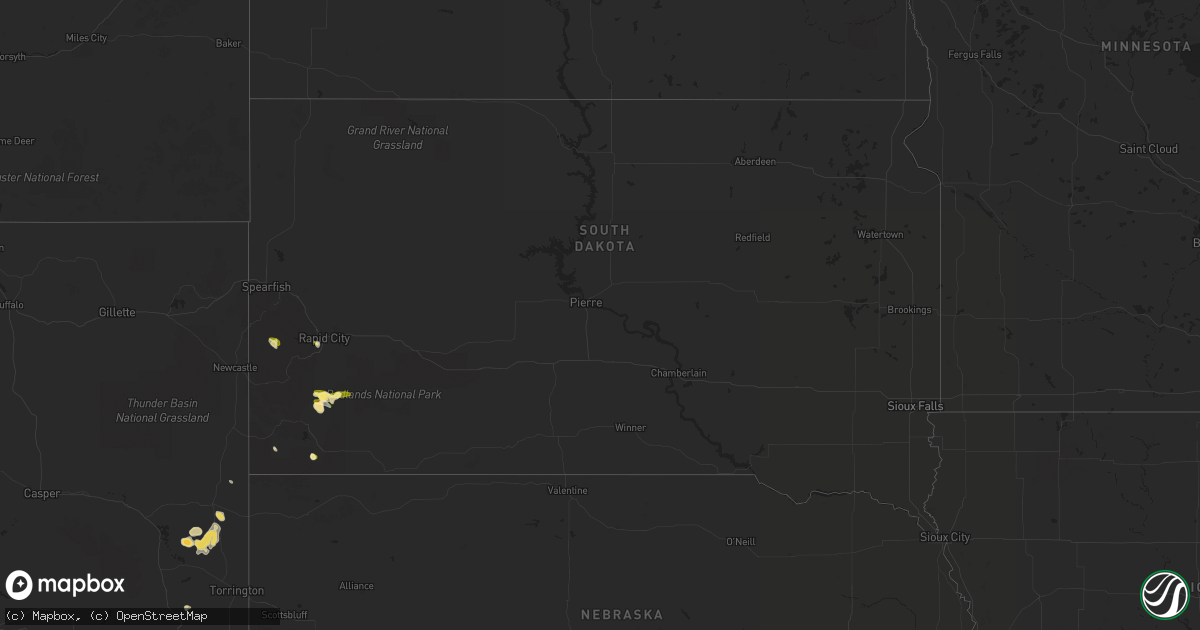
Hail Map in South Dakota on July 29, 2022
Get this storm
July 29 map
$229
one time, instant access
Download today. No call, no setup
Keep the $229
Bought the map and want the full workflow? Apply the entire $229 to a subscription within 7 days. None of it is wasted.
Every map, not just this one
This buys you this map. Subscription and you get every map we run, in the markets you choose from a few cities to whole states to nationwide. Plus real-time alerts the moment a storm fires.
Contact data
Name, contact info, occupancy, even credit band for addresses in the footprint. You go from where it hit to who to call.
Become the source they trust
Unlimited branding weather history reports on demand. You already have the documented answer ready for the property owner, and you are the one who showed up with it.
Property data and RoofTrace estimates
Pull up any address you have got, its value and the exact code rules for that jurisdiction, straight from One Click Code. Then RoofTrace estimates the squares, pitch, and roof value, priced the way you price.
Storm reports in South Dakota
South Dakota
| Date | Description |
|---|---|
| 07/29/20226:01 PM CDT | A local report indicates 1.00 inch wind near 4 SW DWTN RAPID CITY |
| 07/29/20225:00 PM CDT | 60-70 mph winds... Pea size hail |
| 07/28/202210:49 PM CDT | At 349 PM MDT, a severe thunderstorm was located 4 miles north of Buffalo Gap, or 12 miles northeast of Hot Springs, moving southeast at 10 mph. HAZARD...Ping pong ball size hail and 60 mph wind gusts. SOURCE...Radar indicated. IMPACT...People and animals outdoors will be injured. Expect hail damage to roofs, siding, windows, and vehicles. Expect wind damage to roofs, siding, and trees. This severe thunderstorm will be near... Buffalo Gap around 405 PM MDT.Other locations in the path of this severe thunderstorm include Oral. |
All States Impacted by Hail Map on July 29, 2022
Cities Impacted by Hail Map on July 29, 2022
- Pendroy, MT
- Bynum, MT
- Joliet, MT
- Dunnsville, VA
- Tappahannock, VA
- Dumas, TX
- Mescalero, NM
- Crossville, AL
- Lockney, TX
- Sparkman, AR
- Canyon, TX
- Happy, TX
- Iowa Park, TX
- Wichita Falls, TX
- Cape Coral, FL
- Breckenridge, TX
- Edgemont, SD
- Amarillo, TX
- Rapid City, SD
- Big Timber, MT
- Lusk, WY
- Floydada, TX
- Williamsburg, VA
- Claude, TX
- Clarendon, TX
- Nara Visa, NM
- Groveoak, AL
- Panhandle, TX
- Trementina, NM
- Hereford, TX
- Oelrichs, SD
- Jay Em, WY
- Harrison, NE
- Hedley, TX
- Seymour, TX
- Clayton, NM
- Grenville, NM
- Sandy Hook, VA
- Bumpass, VA
- Gum Spring, VA
- Maidens, VA
- Mineral, VA
- Pampa, TX
- Hill City, SD
- Raynesford, MT
- Silverton, TX
- Jefferson, GA
- Glendo, WY
- Hartville, WY
- Gallup, NM
- Chester, SC
- Blackstock, SC
- Skellytown, TX
- White Deer, TX
- Columbus, MT
- Dawson, AL
- Collinsville, AL
- Guntersville, AL
- Albertville, AL
- Fort Payne, AL
- Scottsboro, AL
- Watson, OK
- Arkadelphia, AR
- Cascade, MT
- Bethune, SC
- Littlefield, AZ
- Kingman, AZ
- Elberton, GA
- Fyffe, AL
- Geraldine, AL
- Buffalo Gap, SD
- Fairburn, SD
- Wheatland, WY
- Amistad, NM
- Rockville, VA
- Crozier, VA
- Manakin Sabot, VA
- Oilville, VA
- Groom, TX
- Fort Benton, MT
- Boswell, OK
- Tremont, MS
- Hamilton, AL
- Vega, TX
- Forestburg, TX
- Kress, TX
- Plainview, TX
- Saint George, UT
- Lakeview, TX
- Bokeelia, FL
- Belzoni, MS
- Ringling, OK
- Wilson, OK
- Fouke, AR
- Texarkana, AR
- Logan, NM
- Tucumcari, NM
- Mosquero, NM
- Lexington, MS
- Keithville, LA
- Ryan, OK
- Naples, FL
- Coila, MS
- Saint Jo, TX
- Choteau, MT
- Crawford, NE
- San Jon, NM


