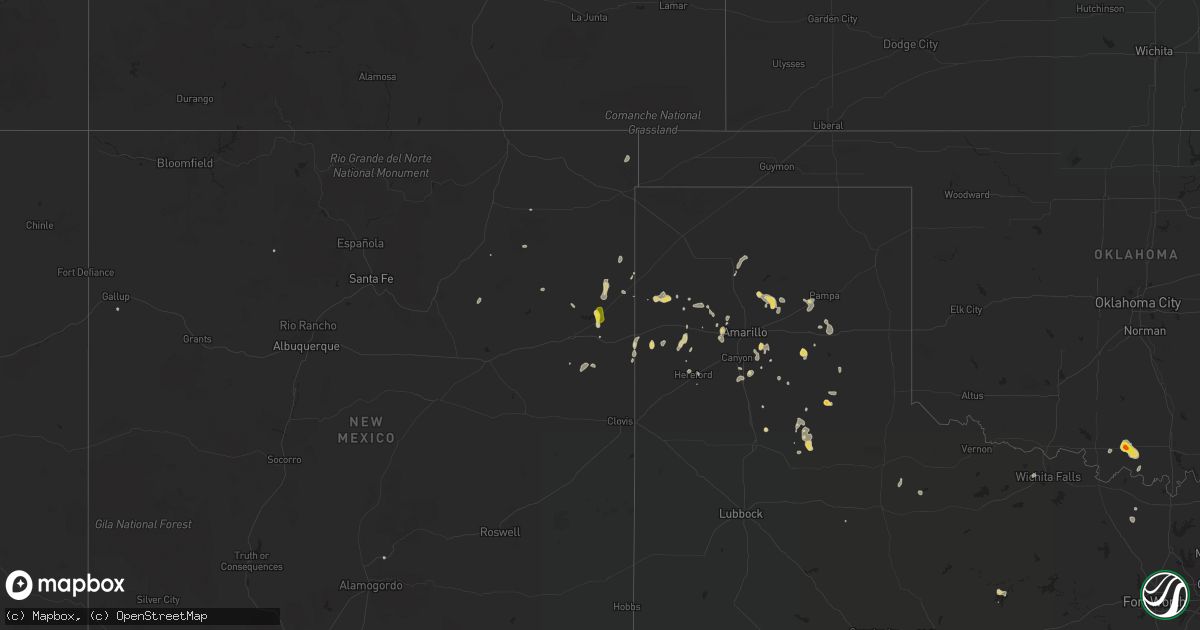
Hail Map on July 29, 2022
Get this storm
July 29 map
$229
one time, instant access
Download today. No call, no setup
Keep the $229
Bought the map and want the full workflow? Apply the entire $229 to a subscription within 7 days. None of it is wasted.
Every map, not just this one
This buys you this map. Subscription and you get every map we run, in the markets you choose from a few cities to whole states to nationwide. Plus real-time alerts the moment a storm fires.
Contact data
Name, contact info, occupancy, even credit band for addresses in the footprint. You go from where it hit to who to call.
Become the source they trust
Unlimited branding weather history reports on demand. You already have the documented answer ready for the property owner, and you are the one who showed up with it.
Property data and RoofTrace estimates
Pull up any address you have got, its value and the exact code rules for that jurisdiction, straight from One Click Code. Then RoofTrace estimates the squares, pitch, and roof value, priced the way you price.
States Impacted by Hail Map on July 29, 2022
Storm reports
North Carolina
| Date | Description |
|---|---|
| 07/29/20226:28 PM CDT | Power outages due to fallen trees near stovall. Time estimated by radar. |
| 07/29/20225:45 PM CDT | Tree down on powerlines along efland cedar grove rd. |
| 07/29/20225:35 PM CDT | At least several trees down and numerous large limbs with one tree down next to the georgeville fire department. |
| 07/29/20225:30 PM CDT | County 911 reported georgeville and flowes store vfds dispatched to clear tree and utility line damage. |
| 07/29/20224:45 PM CDT | Multiple trees down near the intersection of saint pauls hwy and gold hill rd. Time estimated by radar. |
| 07/29/20223:33 AM CDT | At 832 PM EDT, a severe thunderstorm was located near Raleigh, moving east at 35 mph. HAZARD...60 mph wind gusts, heavy rain, and frequent lightning. SOURCE...Radar indicated. IMPACT...Expect damage to roofs, siding, and trees. Locations impacted include... Raleigh, Wake Forest, Zebulon, Knightdale, Wendell, Rolesville and Falls Lake. |
| 07/29/20222:04 AM CDT | At 702 PM EDT, a cluster of severe thunderstorms were located from near Virgilina to 7 miles east of Rougemont, moving east at 20 mph. HAZARD...60 mph wind gusts, heavy rain, and frequent lightning. SOURCE...Radar indicated. IMPACT...Expect damage to roofs, siding, and trees. Locations impacted include... Henderson, Oxford, Butner, Kittrell, Stem, Stovall, Middleburg, Lake Michie, Gillburg and Steele Creek Marina & Campground. |
| 07/29/20221:38 AM CDT | At 638 PM EDT, a severe thunderstorm was located over Prospect Hill, moving east at 20 mph. HAZARD...60 mph wind gusts. SOURCE...Radar indicated. IMPACT...Expect damage to roofs, siding, and trees. Locations impacted include... Rougemont, Carr, Bushy Fork, Lake Michie, Surl, Bahama and Schley. |
| 07/29/20221:35 AM CDT | At 635 PM EDT, a severe thunderstorm was located near Troy, moving east at 20 mph. HAZARD...60 mph wind gusts. SOURCE...Radar indicated. IMPACT...Expect damage to roofs, siding, and trees. Locations impacted include... Troy, Biscoe, Seagrove, Robbins, Star and Steeds. |
| 07/29/20221:34 AM CDT | At 633 PM EDT, a severe thunderstorm was located near Midland, or 9 miles southeast of Downtown Concord, moving east at 20 mph. HAZARD...60 mph wind gusts. SOURCE...Radar indicated. IMPACT...Expect damage to roofs, siding, and trees. Locations impacted include... Albemarle, Badin Lake, Plyler, Fairview In Union County, Locust, Norwood, Badin, Oakboro, Stanfield and Richfield. |
| 07/29/20221:29 AM CDT | At 629 PM EDT, a severe thunderstorm was located 8 miles southeast of Downtown Concord, or 5 miles north of Midland, moving east at 25 mph. HAZARD...60 mph wind gusts. SOURCE...Radar indicated. IMPACT...Expect damage to trees and power lines. Locations impacted include... Mt Pleasant, Midland and Downtown Concord. |
| 07/29/20221:28 AM CDT | At 628 PM EDT, severe thunderstorms were located along a line extending from 11 miles northwest of Clinton to near Jerome, moving east at 30 mph. HAZARD...60 mph wind gusts. SOURCE...Radar indicated. IMPACT...Expect damage to roofs, siding, and trees. Locations impacted include... Clinton, Mount Olive, Roseboro, Stedman, Garland, Newton Grove, Salemburg, Turkey, Falcon and Autryville. |
| 07/29/20221:04 AM CDT | At 604 PM EDT, severe thunderstorms were located along a line extending from near Back Bay to Indiantown, moving east at 25 mph. HAZARD...60 mph wind gusts. SOURCE...Radar indicated. IMPACT...Expect damage to trees and powerlines. Severe thunderstorms will be near... Knotts Island around 615 PM EDT. Grandy around 635 PM EDT. Corolla around 640 PM EDT.Other locations impacted by these severe thunderstorms includeBelcross, Poplar Branch, Aydlett, Gregory, Jarvisburg, Barco,Coinjock, Riddle, Waterlily and Bertha. |
| 07/29/202212:50 AM CDT | At 549 PM EDT, a severe thunderstorm was located near Raeford, moving east at 20 mph. HAZARD...60 mph wind gusts and penny size hail, and frequent lightning. SOURCE...Radar indicated. IMPACT...Expect damage to roofs, siding, and trees. Locations impacted include... Fayetteville, Raeford, Fort Bragg, Antioch, Pope AFB, Hope Mills, Spring Lake, Eastover, Stedman and Wade. |
| 07/29/202212:33 AM CDT | At 533 PM EDT, a severe thunderstorm was located over Virginia Beach, moving east at 35 mph. HAZARD...60 mph wind gusts. SOURCE...Radar indicated. IMPACT...Expect damage to trees and powerlines. This severe thunderstorm will remain over mainly rural areas of , the southeastern City of Chesapeake and the City of Virginia Beach, including the following locations... Rudee Heights, Mount Pleasant, Princess Anne Plaza, Sigma, Sandbridge Beach, Oceana NAS, Munden, Macons Corner, Pungo and Bayside. |
| 07/28/20227:34 PM CDT | Power outage caused by fallen trees. Time estimated by radar. |
New Mexico
| Date | Description |
|---|---|
| 07/29/20225:18 PM CDT | Spotter reports lot of hail with storm in logan with the largest size of about quarters. Hail did a lot of damage to tree leaves and destroyed their garden. They also r |
| 07/28/202211:31 PM CDT | At 431 PM MDT, a severe thunderstorm was located 7 miles southwest of Trujillo, or 28 miles east of Las Vegas, and is nearly stationary. HAZARD...60 mph wind gusts and quarter size hail. SOURCE...Radar indicated. IMPACT...Hail damage to vehicles is expected. Expect wind damage to roofs, siding, and trees. Locations impacted include... Trujillo and Trementina. This includes State Road 104 between Mile Markers 23 and 47. |
| 07/28/202211:24 PM CDT | At 424 PM MDT, a severe thunderstorm was located over Logan, or 20 miles northeast of Tucumcari, moving north at 10 mph. HAZARD...60 mph wind gusts and half dollar size hail. SOURCE...Radar indicated. IMPACT...Hail damage to vehicles is expected. Expect wind damage to roofs, siding, and trees. Locations impacted include... Logan and Ute Lake State Park. |
Nevada
| Date | Description |
|---|---|
| 07/29/20223:33 PM CDT | Mesonet station ntgnv 14.1 sw trinity junction |
| 07/29/20223:12 AM CDT | At 812 PM PDT, a severe thunderstorm was located over Paradise, and is moving south at 15 mph. HAZARD...60 mph wind gusts. SOURCE...Radar indicated. IMPACT...Expect damage to roofs and trees. Locations impacted include... Las Vegas, Henderson, North Las Vegas, Boulder City, Lone Mountain, Anthem, Summerlin, Mountains Edge, The Strip, Nellis AFB, Blue Diamond, Downtown Las Vegas, East Las Vegas, Sam Boyd Stadium, The Motor Speedway, Southern Highlands, Aliante, Jean, Lake Las Vegas and Spring Valley.This includes Interstate 15 in Nevada between mile markers 11 and 25. |
| 07/29/20221:16 AM CDT | At 616 PM PDT, a severe thunderstorm was located over Coyote Springs, or 19 miles northwest of Moapa Town, moving south at 55 mph. HAZARD...60 mph wind gusts. SOURCE...Radar indicated. IMPACT...Expect damage to roofs and trees. Locations impacted include... Moapa Town, Moapa Valley, Sr 168 Mile Marker 21 and Coyote Springs.This includes the following highways... Interstate 15 in Arizona near mile marker 3. Interstate 15 in Nevada between mile markers 80 and 100. |
| 07/28/202210:00 PM CDT | Social media images show several trees down on cars and apartment buildings. Time estimated via radar. |
| 07/28/202210:00 PM CDT | Images on social media show several trees down in the road. Time estimated via radar. |
Mississippi
| Date | Description |
|---|---|
| 07/28/202211:46 PM CDT | At 446 PM CDT, a severe thunderstorm was located over Renova, or near Cleveland, moving northeast at 5 mph. HAZARD...60 mph wind gusts. SOURCE...Radar indicated. IMPACT...Expect damage to roofs, siding, and trees. This severe thunderstorm will be near... Mound Bayou around 510 PM CDT. Drew and Parchman around 545 PM CDT.Other locations impacted by this severe thunderstorm includeMerigold. |
Georgia
| Date | Description |
|---|---|
| 07/29/20223:30 PM CDT | Several trees and power lines were downed in the area of cabin creek road and js williamson court. |
| 07/29/20223:28 PM CDT | A tree was downed onto a home on north bowden street. |
| 07/29/20221:27 AM CDT | At 627 PM EDT, a severe thunderstorm was located near Brick Store, or 10 miles east of Covington, moving east at 15 mph. HAZARD...60 mph wind gusts. SOURCE...Radar indicated. IMPACT...Expect damage to roofs, siding, and trees. Locations impacted include... Madison, Social Circle, Rutledge, Newborn, Godfrey, Hard Labor Creek State Park and Brick Store. |
| 07/29/202212:11 AM CDT | At 511 PM EDT, a severe thunderstorm was located over Brookhaven, or near Decatur, moving east at 20 mph. HAZARD...60 mph wind gusts and quarter size hail. SOURCE...Radar indicated. IMPACT...Hail damage to vehicles is expected. Expect wind damage to roofs, siding, and trees. Locations impacted include... Atlanta, Decatur, Sandy Springs, Dunwoody, Chamblee, Doraville, Clarkston, Stone Mountain, Avondale Estates, Pine Lake, Tucker, Belvedere Park, North Decatur, North Atlanta, North Druid Hills, Midtown, Candler-Mcafee, Druid Hills, Mountain Park and Piedmont Park. |
| 07/28/202211:24 PM CDT | At 423 PM EDT, a severe thunderstorm was located over Apple Valley, or over Jefferson, moving east at 20 mph. HAZARD...60 mph wind gusts and quarter size hail. SOURCE...Radar indicated. IMPACT...Hail damage to vehicles is expected. Expect wind damage to roofs, siding, and trees. Locations impacted include... Jefferson, Commerce, Danielsville, Maysville, Arcade, Nicholson, Comer, Colbert, Ila, Hull, Pocataligo, Peach State Speedway, Diamond Hill, Paoli, Apple Valley, Neese and Banks Crossing. |
Virginia
| Date | Description |
|---|---|
| 07/29/20224:55 PM CDT | Sandbridge wxflow site. |
| 07/29/20224:17 PM CDT | Powerlines down. |
| 07/29/20223:25 PM CDT | Trees downed on eagle point plantation rd at warner hall rd. |
| 07/29/20223:05 PM CDT | Downed tree blocking roadway. Time estimated. |
| 07/29/20222:45 PM CDT | Road blocked by downed tree. Time estimated. |
| 07/29/20221:45 PM CDT | Downed trees knocked over powerlines. Time estimated. |
| 07/29/20221:40 PM CDT | Tree on powerline near st stephens church in king and queen county. Time estimated. |
| 07/29/20221:30 PM CDT | Vdot reports downed tree blocking road. Time estimated. |
| 07/29/20221:20 PM CDT | Henrico police reports downed tree blocking road. |
| 07/29/202212:50 PM CDT | Road blocked by downed tree. Time estimated. |
| 07/29/202212:50 PM CDT | Road blocked by downed tree. Time estimated. |
| 07/29/202212:30 PM CDT | Two trees down on top of powerline. Time estimated from radar. |
| 07/28/202211:23 PM CDT | At 422 PM EDT, severe thunderstorms were located along a line extending from near Tangier to 10 miles northwest of Exmore to 11 miles east of Gwynn, moving east at 25 mph. HAZARD...60 mph wind gusts. SOURCE...Radar indicated. IMPACT...Expect damage to trees and powerlines. Severe thunderstorms will be near... Onancock and Nassawadox around 450 PM EDT. Exmore, Onley and Willis Wharf around 455 PM EDT. Parksley around 505 PM EDT.Other locations impacted by these severe thunderstorms includeHallwood, Harborton, Melfa, Mappsville, Jamesville, Silver Beach,Wachapreague, Wardtown, Franktown and Accomac. |
| 07/28/202211:15 PM CDT | At 415 PM EDT, a severe thunderstorm was located near Queens Lake, moving east at 30 mph. HAZARD...60 mph wind gusts and penny size hail. SOURCE...Radar indicated. IMPACT...Expect damage to trees and powerlines. This severe thunderstorm will be near... Gloucester Courthouse, Gloucester Point, Virginia Institute For Marine Sciences, Wicomico and Hayes around 425 PM EDT. Achilles around 430 PM EDT. Mobjack around 445 PM EDT. Mathews and Bavon around 450 PM EDT.Other locations impacted by this severe thunderstorm include Ruff,Beulah, Moon, Laban, Camp Peary, Glass, Naxera, Allmondsville, ClayBank and Port Haywood. |
| 07/28/202210:56 PM CDT | At 356 PM EDT, severe thunderstorms were located along a line extending from near Powhatan to near Amelia Courthouse to near Rice, moving east at 35 mph. HAZARD...60 mph wind gusts. SOURCE...Radar indicated. IMPACT...Expect damage to trees and powerlines. Severe thunderstorms will be near... Powhatan, Amelia Courthouse and Macon around 400 PM EDT. Chula around 405 PM EDT. Scotts Fork around 410 PM EDT. Moseley, Sabot and Manakin around 415 PM EDT. Tuckahoe around 420 PM EDT. Bon Air and Mannboro around 435 PM EDT.Other locations impacted by these severe thunderstorms include RockCastle, Pilkinton, Winterham, Skinquarter, Maplewood, Fine CreekMills, Deatonville, Holly Hills, Lodore and Lake Powhatan. |
| 07/28/20229:31 PM CDT | At 231 PM EDT, severe thunderstorms were located along a line extending from near Champlain to Manquin, moving northeast at 25 mph. HAZARD...60 mph wind gusts. SOURCE...Radar indicated. IMPACT...Expect damage to trees and powerlines. Severe thunderstorms will be near... Tappahannock around 245 PM EDT. Stevensville around 255 PM EDT. Warsaw and Millers Tavern around 300 PM EDT. Haynesville around 310 PM EDT. Center Cross, Hague, Dunnsville and Sharps around 315 PM EDT.Other locations impacted by these severe thunderstorms includeThreeway, Upright, Ino, Biscoe, Tidewater, Lyells, Crouch, Kennard,Mount Landing and Piney Grove. |
| 07/28/20229:11 PM CDT | At 209 PM EDT, severe thunderstorms were located along a line extending from Kings Dominion to near Tuckahoe, moving east at 35 mph. HAZARD...60 mph wind gusts. SOURCE...Radar indicated. IMPACT...Expect damage to trees and powerlines. Severe thunderstorms will be near... Kings Dominion around 215 PM EDT. Hanover, Dawn and East Highland Park around 220 PM EDT. Highland Springs, Mechanicsville and Mangohick around 225 PM EDT. Beulahville and Studley around 235 PM EDT. Aylett and Manquin around 240 PM EDT. Saint Stephens Church around 250 PM EDT.Other locations impacted by these severe thunderstorms includeEnfield, Central Garage, Hanover Airport, Gum Tree, Upshaw, Elmont,Etna Mills, Longdale, Epworth and Westwood. |
| 07/28/20228:25 PM CDT | At 125 PM EDT, a severe thunderstorm was located over Gum Spring, or near Goochland, moving east at 35 mph. HAZARD...60 mph wind gusts and penny size hail. SOURCE...Radar indicated. IMPACT...Expect damage to trees and powerlines. This severe thunderstorm will be near... Oilville around 135 PM EDT. Montpelier around 145 PM EDT. Tuckahoe and Wyndham around 150 PM EDT. Ashland, Randolph Macon College, Glen Allen and Laurel around 205 PM EDT.Other locations impacted by this severe thunderstorm include Orchid,Crozier, Sandy Hook, Vontay, Maidens, Gum Tree, Three Square, Irwin,Johnsons Springs and Goodall. |
Texas
| Date | Description |
|---|---|
| 07/29/20226:24 PM CDT | Corrects previous tstm wnd dmg report from bushland. Roof partially blown off a business. |
| 07/29/20225:42 PM CDT | A local report indicates 66 MPH wind near 7 ESE SILVERTON |
| 07/29/20222:13 PM CDT | A local report indicates 59 MPH wind near 3 ENE VAN HORN |
| 07/29/20222:07 AM CDT | At 707 PM CDT, severe thunderstorms were located along a line extending from 7 miles southeast of Nara Visa to 17 miles north of Adrian to 7 miles southwest of Boys Ranch, moving northeast at 25 mph. HAZARD...60 mph wind gusts and nickel size hail. SOURCE...Radar indicated. IMPACT...Minor damage to roofs, siding, and trees is possible. Locations impacted include... Channing, Boys Ranch, Masterson, Four Way, Valley De Oro and Romero. |
| 07/29/20221:40 AM CDT | At 639 PM CDT, a severe thunderstorm was located 11 miles south of Fritch, or 12 miles northwest of Panhandle, moving east at 15 mph. HAZARD...60 mph wind gusts and quarter size hail. SOURCE...Radar indicated. IMPACT...Minor damage to roofs, siding, and trees is possible. Hail damage to vehicles is expected. This severe thunderstorm will remain over mainly rural areas of central Carson County. |
| 07/29/20221:18 AM CDT | At 618 PM CDT, severe thunderstorms were located along a line extending from 5 miles southwest of Bushland to Mescalero Park to 4 miles north of Palo Duro Canyon, moving northeast at 20 mph. HAZARD...60 mph wind gusts and penny size hail. SOURCE...Radar indicated. IMPACT...Minor damage to roofs, siding, and trees is possible. Locations impacted include... Amarillo, Canyon, Panhandle, Lake Tanglewood, Mescalero Park, Bushland, Washburn, Palo Duro Canyon, Timbercreek Canyon and Pantex. |
| 07/29/20221:08 AM CDT | At 607 PM CDT, severe thunderstorms were located along a line extending from near Glenrio to 14 miles southwest of Adrian to 4 miles northwest of Simms to 11 miles southwest of Vega to 8 miles northwest of Dawn, moving north at 20 mph. HAZARD...60 mph wind gusts. SOURCE...Radar indicated. IMPACT...Minor damage to roofs, siding, and trees is possible. Locations impacted include... Vega, Adrian, Glenrio, Wildorado and Simms. |
| 07/29/202212:43 AM CDT | At 543 PM CDT, a severe thunderstorm was located 5 miles south of Lake Meredith, or 15 miles southwest of Borger, moving northeast at 5 mph. HAZARD...60 mph wind gusts and penny size hail. SOURCE...Radar indicated. IMPACT...Minor damage to roofs, siding, and trees is possible. Locations impacted include... Borger, Fritch, Sanford and Lake Meredith. |
| 07/29/202212:28 AM CDT | At 528 PM MDT, a severe thunderstorm was located 11 miles west of Nara Visa, moving northeast at 20 mph. HAZARD...60 mph wind gusts and quarter size hail. SOURCE...Radar indicated. IMPACT...Hail damage to vehicles is expected. Expect wind damage to roofs, siding, and trees. Locations impacted include... Amistad, Hayden and Rosebud. |
| 07/29/202212:21 AM CDT | At 521 PM CDT, a severe thunderstorm was located near Iowa Park, moving north at 10 mph. HAZARD...60 mph wind gusts and quarter size hail. SOURCE...Radar indicated. IMPACT...Hail damage to vehicles is expected. Expect wind damage to roofs, siding, and trees. Locations impacted include... Wichita Falls, Burkburnett, Iowa Park, Sheppard AFB, Pleasant Valley and Cashion. |
| 07/28/202210:30 PM CDT | West texas mesonet site at g |
| 07/28/202210:30 PM CDT | West texas mesonet site at goodnight. First severe wind gust of 59 mph was recorded at 10:28 pm with the peak being 62 mph. |
Arkansas
| Date | Description |
|---|---|
| 07/29/20227:03 AM CDT | At 1203 AM CDT, severe thunderstorms were located along a line extending from near Huntsville to 2 miles northwest of Winslow, moving east at 25 mph. HAZARD...60 mph wind gusts and quarter size hail. SOURCE...Radar indicated. IMPACT...Hail damage to vehicles is expected. Expect wind damage to roofs, siding, and trees. Locations in or near the path include... Huntsville... Winslow... St. Paul... Wesley... Saint Paul... Kingston... Aurora... Boston... Devils Den State Park... Pettigrew... Brentwood... Japton... Witter... Marble... Georgetown... Red Star... Alabam... Crosses... Combs... Dutton...This includes Interstate 49 between mile markers 41 and 46. |
| 07/28/20228:53 PM CDT | At 153 PM CDT, a severe thunderstorm was located over Arkadelphia, moving southeast at 30 mph. HAZARD...60 mph wind gusts and quarter size hail. SOURCE...Radar indicated. IMPACT...Hail damage to vehicles is expected. Expect wind damage to roofs, siding, and trees. Locations impacted include... Arkadelphia... Caddo Valley... Sparkman... Gum Springs in Clark County... Richwoods... Lower Lake Recreation Area... Curtis... Manning... Ouachita... Joan... Willow... Dalark... Griffithtown... This includes Interstate 30 between mile markers 64 and 78. |
| 07/28/20228:35 PM CDT | At 135 PM CDT, a severe thunderstorm was located 7 miles southwest of DeGray Lake State Park, or 10 miles west of Arkadelphia, moving northeast at 15 mph. HAZARD...60 mph wind gusts and quarter size hail. SOURCE...Radar indicated. IMPACT...Hail damage to vehicles is expected. Expect wind damage to roofs, siding, and trees. Locations impacted include... Arkadelphia... Caddo Valley... Halfway... DeGray Lake State Park... Friendship... Bismarck... Alpine... Joan... Hollywood... Lower Lake Recreation Area... De Roche... This includes Interstate 30 between mile markers 69 and 84. |
Oklahoma
| Date | Description |
|---|---|
| 07/29/20223:00 PM CDT | A local report indicates 60 MPH wind near 1 N RINGLING |
| 07/28/202210:04 PM CDT | At 304 PM CDT, a severe thunderstorm was located near Ringling, moving north at 15 mph. HAZARD...60 mph wind gusts and quarter size hail. SOURCE...Radar indicated. IMPACT...Hail damage to vehicles is expected. Expect wind damage to roofs, siding, and trees. Locations impacted include... Healdton, Ringling, Velma, Tatums, Loco, Ratliff City, Cornish and Fox. |
| 07/28/20229:49 PM CDT | At 249 PM CDT, a severe thunderstorm was located 4 miles southeast of Ringling, moving north at 15 mph. HAZARD...60 mph wind gusts and nickel size hail. SOURCE...Radar indicated. IMPACT...Expect damage to roofs, siding, and trees. Locations impacted include... Healdton, Wilson, Ringling, Graham, Cornish and Fox. |
Colorado
| Date | Description |
|---|---|
| 07/29/20225:37 PM CDT | Several photos and videos provided by public sources indicate a landspout occurred in the area. This landspout moved slowly southwestward for several minutes with no da |
| 07/29/20225:26 PM CDT | Numerous photos and videos from an off-duty nws employee and social media confirm a brief landspout tornado occurred just northeast of the buckley afb. Trained spotters |
| 07/29/20221:21 AM CDT | At 620 PM MDT, a severe thunderstorm was located near Falcon, or 17 miles northeast of Colorado Springs, moving south at 15 mph. HAZARD...60 mph wind gusts. SOURCE...Radar indicated. IMPACT...Expect damage to roofs, siding, and trees. Locations impacted include... Eastern Colorado Springs, Peyton, Falcon and Cimarron Hills. |
South Dakota
| Date | Description |
|---|---|
| 07/29/20226:01 PM CDT | A local report indicates 1.00 inch wind near 4 SW DWTN RAPID CITY |
| 07/29/20225:00 PM CDT | 60-70 mph winds... Pea size hail |
| 07/28/202210:49 PM CDT | At 349 PM MDT, a severe thunderstorm was located 4 miles north of Buffalo Gap, or 12 miles northeast of Hot Springs, moving southeast at 10 mph. HAZARD...Ping pong ball size hail and 60 mph wind gusts. SOURCE...Radar indicated. IMPACT...People and animals outdoors will be injured. Expect hail damage to roofs, siding, windows, and vehicles. Expect wind damage to roofs, siding, and trees. This severe thunderstorm will be near... Buffalo Gap around 405 PM MDT.Other locations in the path of this severe thunderstorm include Oral. |
Wyoming
| Date | Description |
|---|---|
| 07/29/20223:45 AM CDT | At 844 PM MDT, a severe thunderstorm was located near Guernsey Campground, or 26 miles northeast of Wheatland, moving southwest at 10 mph. HAZARD...Two inch hail. SOURCE...Radar indicated. IMPACT...People and animals outdoors will be injured. Expect damage to roofs, siding, windows, and vehicles. Locations impacted include... Guernsey, Guernsey Campground and Hartville. |
| 07/29/20223:00 AM CDT | At 759 PM MDT, a severe thunderstorm was located 11 miles southwest of Rawhide Buttes, or 24 miles south of Lusk, moving southwest at 10 mph. HAZARD...Quarter size hail. SOURCE...Radar indicated. IMPACT...Damage to vehicles is expected. Locations impacted include... Guernsey, Guernsey Campground, Fort Laramie National Historic Site and Hartville. |
| 07/29/20222:31 AM CDT | At 730 PM MDT, a severe thunderstorm was located near Rawhide Buttes, or 16 miles southwest of Lusk, moving south at 15 mph. HAZARD...Half dollar size hail. SOURCE...Radar indicated. IMPACT...Damage to vehicles is expected. This severe thunderstorm will remain over mainly rural areas of northwestern Goshen and northeastern Platte Counties. |
| 07/29/20222:09 AM CDT | At 708 PM MDT, a severe thunderstorm was located near Jay Em, or 19 miles south of Lusk, moving south at 15 mph. HAZARD...Quarter size hail. SOURCE...Radar indicated. IMPACT...Damage to vehicles is expected. Locations impacted include... Jay Em. |
| 07/29/202212:45 AM CDT | At 544 PM MDT, a severe thunderstorm was located 7 miles southeast of Lusk, moving east at 10 mph. HAZARD...Quarter size hail. SOURCE...Radar indicated. IMPACT...Damage to vehicles is expected. Locations impacted include... Prairie Center and Van Tassell. |
Maryland
| Date | Description |
|---|---|
| 07/28/202210:07 PM CDT | At 306 PM EDT, severe thunderstorms were located along a line extending from near Sharps to near Shacklefords, moving east at 25 mph. HAZARD...60 mph wind gusts. SOURCE...Radar indicated. IMPACT...Expect damage to trees and powerlines. Severe thunderstorms will be near... Sharps around 310 PM EDT. Farnham, Morattico and Church View around 315 PM EDT. Robley around 320 PM EDT. Glenns and Saluda around 325 PM EDT. Urbanna around 330 PM EDT. Lancaster and Heathsville around 335 PM EDT. Hartfield and Wicomico Church around 345 PM EDT. White Stone around 350 PM EDT.Other locations impacted by these severe thunderstorms includeByrdton, Avalon, Brook Vale, Bertrand, Grafton, Reedville, Belle IsleState Park, Amburg, Millenbeck and Mattaponi. |
Nebraska
| Date | Description |
|---|---|
| 07/28/20229:10 PM CDT | At 210 PM MDT, a severe thunderstorm was located near Montrose, or 28 miles south of Edgemont, and is nearly stationary. HAZARD...Ping pong ball size hail. SOURCE...Radar indicated. IMPACT...People and animals outdoors will be injured. Expect damage to roofs, siding, windows, and vehicles. This severe thunderstorm will remain over mainly rural areas of north central Sioux County.A Flash Flood Warning is also in effect for the same area until 500 PM MDT this afternoon. |
Arizona
| Date | Description |
|---|---|
| 07/29/20222:33 AM CDT | At 732 PM PDT/732 PM MST/, a severe thunderstorm was located near Callville Bay Campground, or 8 miles northeast of Las Vegas Bay, moving southeast at 30 mph. HAZARD...60 mph wind gusts. SOURCE...Radar indicated. IMPACT...Expect damage to roofs and trees. Locations impacted include... Las Vegas, Henderson, North Las Vegas, Mesquite, Boulder City, Anthem, The Strip, Nellis AFB, Downtown Las Vegas, East Las Vegas, Sam Boyd Stadium, The Motor Speedway, Las Vegas Bay, Lake Las Vegas, Overton, Green Valley, Moapa Town, Paradise, Enterprise and Moapa Valley.This includes Interstate 15 in Nevada between mile markers 60 and117. |
| 07/29/20221:48 AM CDT | At 647 PM PDT/647 PM MST/, a severe thunderstorm was located 26 miles southeast of Bunkerville, or 26 miles south of Littlefield, moving south at 15 mph. HAZARD...60 mph wind gusts. SOURCE...Radar indicated. IMPACT...Expect damage to roofs and trees. Locations impacted include... Grand Canyon Skywalk, South Cove and Lake Mead National Recreation Area. |
| 07/28/20229:00 PM CDT | Wind gust of 58 mph was measured at olaf knolls raws site. Observation came in at 733pm... But actual gust was likely closer to 7pm based on radar. |
Alabama
| Date | Description |
|---|---|
| 07/29/20226:50 PM CDT | Trees were reported down on alabama highway 68. |
| 07/29/20226:45 PM CDT | Trees were reported down on cr 104. |
| 07/29/20226:45 PM CDT | Corrects previous tstm wnd dmg report from 1 w crossville. Trees were reported down on alabama highway 68. |
| 07/29/20226:41 PM CDT | Corrects previous tstm wnd dmg report from 2 wnw crossville. Trees were reported down on cr 104. |
| 07/29/20226:40 PM CDT | Trees were reported down on cr 482. |
| 07/29/20226:37 PM CDT | Trees were reported down on cr 9. |
| 07/29/20222:51 AM CDT | At 750 PM CDT, a severe thunderstorm was located over Guntersville, moving northeast at 10 mph. HAZARD...60 mph wind gusts. SOURCE...Radar indicated. IMPACT...Expect damage to roofs, siding, and trees. Locations impacted include... Albertville, Guntersville, McVille, High Point, Hustleville, Rabbit Town, Columbus City, Hyatt, Mountain View and Lake Guntersville St Park. |
| 07/29/20222:16 AM CDT | At 716 PM CDT, a severe thunderstorm was located near Fort Payne, moving northeast at 10 mph. HAZARD...60 mph wind gusts and penny size hail. SOURCE...Radar indicated. IMPACT...Expect damage to roofs, siding, and trees. Locations impacted include... Fort Payne, Rainsville, Valley Head, Hammondville, Pine Ridge, Lebanon, Dog Town, Collbran, Adamsburg and Desoto State Park. |
| 07/29/20221:25 AM CDT | At 624 PM CDT, a severe thunderstorm was located over Crossville, or 10 miles northeast of Boaz, and is nearly stationary. HAZARD...60 mph wind gusts and penny size hail. SOURCE...Radar indicated. IMPACT...Expect damage to roofs, siding, and trees. Locations impacted include... Crossville, Geraldine, Lakeview, Hopewell, Arona, Kilpatrick, Painter, Rodentown, Peeks Corner and Whiton. |
Cities Impacted by Hail Map on July 29, 2022
- Pendroy, MT
- Bynum, MT
- Joliet, MT
- Dunnsville, VA
- Tappahannock, VA
- Dumas, TX
- Mescalero, NM
- Crossville, AL
- Lockney, TX
- Sparkman, AR
- Canyon, TX
- Happy, TX
- Iowa Park, TX
- Wichita Falls, TX
- Cape Coral, FL
- Breckenridge, TX
- Edgemont, SD
- Amarillo, TX
- Rapid City, SD
- Big Timber, MT
- Lusk, WY
- Floydada, TX
- Williamsburg, VA
- Claude, TX
- Clarendon, TX
- Nara Visa, NM
- Groveoak, AL
- Panhandle, TX
- Trementina, NM
- Hereford, TX
- Oelrichs, SD
- Jay Em, WY
- Harrison, NE
- Hedley, TX
- Seymour, TX
- Clayton, NM
- Grenville, NM
- Sandy Hook, VA
- Bumpass, VA
- Gum Spring, VA
- Maidens, VA
- Mineral, VA
- Pampa, TX
- Hill City, SD
- Raynesford, MT
- Silverton, TX
- Jefferson, GA
- Glendo, WY
- Hartville, WY
- Gallup, NM
- Chester, SC
- Blackstock, SC
- Skellytown, TX
- White Deer, TX
- Columbus, MT
- Dawson, AL
- Collinsville, AL
- Guntersville, AL
- Albertville, AL
- Fort Payne, AL
- Scottsboro, AL
- Watson, OK
- Arkadelphia, AR
- Cascade, MT
- Bethune, SC
- Littlefield, AZ
- Kingman, AZ
- Elberton, GA
- Fyffe, AL
- Geraldine, AL
- Buffalo Gap, SD
- Fairburn, SD
- Wheatland, WY
- Amistad, NM
- Rockville, VA
- Crozier, VA
- Manakin Sabot, VA
- Oilville, VA
- Groom, TX
- Fort Benton, MT
- Boswell, OK
- Tremont, MS
- Hamilton, AL
- Vega, TX
- Forestburg, TX
- Kress, TX
- Plainview, TX
- Saint George, UT
- Lakeview, TX
- Bokeelia, FL
- Belzoni, MS
- Ringling, OK
- Wilson, OK
- Fouke, AR
- Texarkana, AR
- Logan, NM
- Tucumcari, NM
- Mosquero, NM
- Lexington, MS
- Keithville, LA
- Ryan, OK
- Naples, FL
- Coila, MS
- Saint Jo, TX
- Choteau, MT
- Crawford, NE
- San Jon, NM