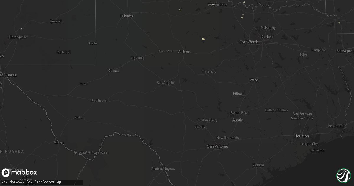
Hail Map in Texas on July 29, 2022
Get this storm
July 29 map
$229
one time, instant access
Download today. No call, no setup
Keep the $229
Bought the map and want the full workflow? Apply the entire $229 to a subscription within 7 days. None of it is wasted.
Every map, not just this one
This buys you this map. Subscription and you get every map we run, in the markets you choose from a few cities to whole states to nationwide. Plus real-time alerts the moment a storm fires.
Contact data
Name, contact info, occupancy, even credit band for addresses in the footprint. You go from where it hit to who to call.
Become the source they trust
Unlimited branding weather history reports on demand. You already have the documented answer ready for the property owner, and you are the one who showed up with it.
Property data and RoofTrace estimates
Pull up any address you have got, its value and the exact code rules for that jurisdiction, straight from One Click Code. Then RoofTrace estimates the squares, pitch, and roof value, priced the way you price.
Storm reports in Texas
Texas
| Date | Description |
|---|---|
| 07/29/20226:24 PM CDT | Corrects previous tstm wnd dmg report from bushland. Roof partially blown off a business. |
| 07/29/20225:42 PM CDT | A local report indicates 66 MPH wind near 7 ESE SILVERTON |
| 07/29/20222:13 PM CDT | A local report indicates 59 MPH wind near 3 ENE VAN HORN |
| 07/29/20222:07 AM CDT | At 707 PM CDT, severe thunderstorms were located along a line extending from 7 miles southeast of Nara Visa to 17 miles north of Adrian to 7 miles southwest of Boys Ranch, moving northeast at 25 mph. HAZARD...60 mph wind gusts and nickel size hail. SOURCE...Radar indicated. IMPACT...Minor damage to roofs, siding, and trees is possible. Locations impacted include... Channing, Boys Ranch, Masterson, Four Way, Valley De Oro and Romero. |
| 07/29/20221:40 AM CDT | At 639 PM CDT, a severe thunderstorm was located 11 miles south of Fritch, or 12 miles northwest of Panhandle, moving east at 15 mph. HAZARD...60 mph wind gusts and quarter size hail. SOURCE...Radar indicated. IMPACT...Minor damage to roofs, siding, and trees is possible. Hail damage to vehicles is expected. This severe thunderstorm will remain over mainly rural areas of central Carson County. |
| 07/29/20221:18 AM CDT | At 618 PM CDT, severe thunderstorms were located along a line extending from 5 miles southwest of Bushland to Mescalero Park to 4 miles north of Palo Duro Canyon, moving northeast at 20 mph. HAZARD...60 mph wind gusts and penny size hail. SOURCE...Radar indicated. IMPACT...Minor damage to roofs, siding, and trees is possible. Locations impacted include... Amarillo, Canyon, Panhandle, Lake Tanglewood, Mescalero Park, Bushland, Washburn, Palo Duro Canyon, Timbercreek Canyon and Pantex. |
| 07/29/20221:08 AM CDT | At 607 PM CDT, severe thunderstorms were located along a line extending from near Glenrio to 14 miles southwest of Adrian to 4 miles northwest of Simms to 11 miles southwest of Vega to 8 miles northwest of Dawn, moving north at 20 mph. HAZARD...60 mph wind gusts. SOURCE...Radar indicated. IMPACT...Minor damage to roofs, siding, and trees is possible. Locations impacted include... Vega, Adrian, Glenrio, Wildorado and Simms. |
| 07/29/202212:43 AM CDT | At 543 PM CDT, a severe thunderstorm was located 5 miles south of Lake Meredith, or 15 miles southwest of Borger, moving northeast at 5 mph. HAZARD...60 mph wind gusts and penny size hail. SOURCE...Radar indicated. IMPACT...Minor damage to roofs, siding, and trees is possible. Locations impacted include... Borger, Fritch, Sanford and Lake Meredith. |
| 07/29/202212:28 AM CDT | At 528 PM MDT, a severe thunderstorm was located 11 miles west of Nara Visa, moving northeast at 20 mph. HAZARD...60 mph wind gusts and quarter size hail. SOURCE...Radar indicated. IMPACT...Hail damage to vehicles is expected. Expect wind damage to roofs, siding, and trees. Locations impacted include... Amistad, Hayden and Rosebud. |
| 07/29/202212:21 AM CDT | At 521 PM CDT, a severe thunderstorm was located near Iowa Park, moving north at 10 mph. HAZARD...60 mph wind gusts and quarter size hail. SOURCE...Radar indicated. IMPACT...Hail damage to vehicles is expected. Expect wind damage to roofs, siding, and trees. Locations impacted include... Wichita Falls, Burkburnett, Iowa Park, Sheppard AFB, Pleasant Valley and Cashion. |
| 07/28/202210:30 PM CDT | West texas mesonet site at goodnight. First severe wind gust of 59 mph was recorded at 10:28 pm with the peak being 62 mph. |
| 07/28/202210:30 PM CDT | West texas mesonet site at g |
All States Impacted by Hail Map on July 29, 2022
Cities Impacted by Hail Map on July 29, 2022
- Pendroy, MT
- Bynum, MT
- Joliet, MT
- Dunnsville, VA
- Tappahannock, VA
- Dumas, TX
- Mescalero, NM
- Crossville, AL
- Lockney, TX
- Sparkman, AR
- Canyon, TX
- Happy, TX
- Iowa Park, TX
- Wichita Falls, TX
- Cape Coral, FL
- Breckenridge, TX
- Edgemont, SD
- Amarillo, TX
- Rapid City, SD
- Big Timber, MT
- Lusk, WY
- Floydada, TX
- Williamsburg, VA
- Claude, TX
- Clarendon, TX
- Nara Visa, NM
- Groveoak, AL
- Panhandle, TX
- Trementina, NM
- Hereford, TX
- Oelrichs, SD
- Jay Em, WY
- Harrison, NE
- Hedley, TX
- Seymour, TX
- Clayton, NM
- Grenville, NM
- Sandy Hook, VA
- Bumpass, VA
- Gum Spring, VA
- Maidens, VA
- Mineral, VA
- Pampa, TX
- Hill City, SD
- Raynesford, MT
- Silverton, TX
- Jefferson, GA
- Glendo, WY
- Hartville, WY
- Gallup, NM
- Chester, SC
- Blackstock, SC
- Skellytown, TX
- White Deer, TX
- Columbus, MT
- Dawson, AL
- Collinsville, AL
- Guntersville, AL
- Albertville, AL
- Fort Payne, AL
- Scottsboro, AL
- Watson, OK
- Arkadelphia, AR
- Cascade, MT
- Bethune, SC
- Littlefield, AZ
- Kingman, AZ
- Elberton, GA
- Fyffe, AL
- Geraldine, AL
- Buffalo Gap, SD
- Fairburn, SD
- Wheatland, WY
- Amistad, NM
- Rockville, VA
- Crozier, VA
- Manakin Sabot, VA
- Oilville, VA
- Groom, TX
- Fort Benton, MT
- Boswell, OK
- Tremont, MS
- Hamilton, AL
- Vega, TX
- Forestburg, TX
- Kress, TX
- Plainview, TX
- Saint George, UT
- Lakeview, TX
- Bokeelia, FL
- Belzoni, MS
- Ringling, OK
- Wilson, OK
- Fouke, AR
- Texarkana, AR
- Logan, NM
- Tucumcari, NM
- Mosquero, NM
- Lexington, MS
- Keithville, LA
- Ryan, OK
- Naples, FL
- Coila, MS
- Saint Jo, TX
- Choteau, MT
- Crawford, NE
- San Jon, NM


