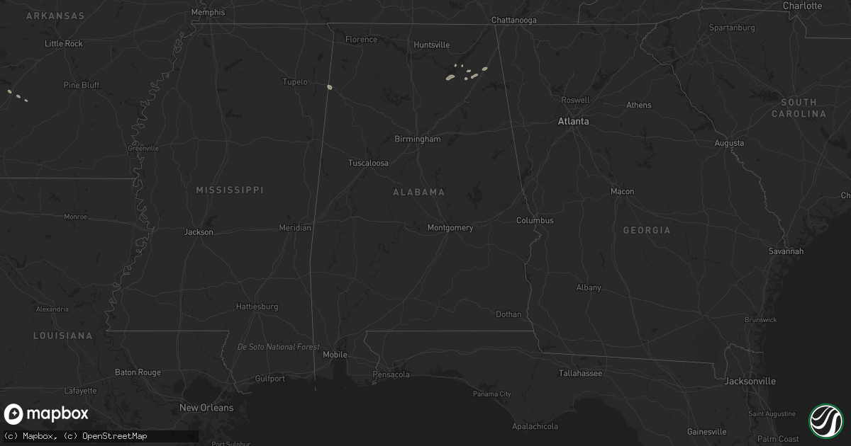
Hail Map in Alabama on July 29, 2022
Get this storm
July 29 map
$229
one time, instant access
Download today. No call, no setup
Keep the $229
Bought the map and want the full workflow? Apply the entire $229 to a subscription within 7 days. None of it is wasted.
Every map, not just this one
This buys you this map. Subscription and you get every map we run, in the markets you choose from a few cities to whole states to nationwide. Plus real-time alerts the moment a storm fires.
Contact data
Name, contact info, occupancy, even credit band for addresses in the footprint. You go from where it hit to who to call.
Become the source they trust
Unlimited branding weather history reports on demand. You already have the documented answer ready for the property owner, and you are the one who showed up with it.
Property data and RoofTrace estimates
Pull up any address you have got, its value and the exact code rules for that jurisdiction, straight from One Click Code. Then RoofTrace estimates the squares, pitch, and roof value, priced the way you price.
Storm reports in Alabama
Alabama
| Date | Description |
|---|---|
| 07/29/20226:50 PM CDT | Trees were reported down on alabama highway 68. |
| 07/29/20226:45 PM CDT | Trees were reported down on cr 104. |
| 07/29/20226:45 PM CDT | Corrects previous tstm wnd dmg report from 1 w crossville. Trees were reported down on alabama highway 68. |
| 07/29/20226:41 PM CDT | Corrects previous tstm wnd dmg report from 2 wnw crossville. Trees were reported down on cr 104. |
| 07/29/20226:40 PM CDT | Trees were reported down on cr 482. |
| 07/29/20226:37 PM CDT | Trees were reported down on cr 9. |
| 07/29/20222:51 AM CDT | At 750 PM CDT, a severe thunderstorm was located over Guntersville, moving northeast at 10 mph. HAZARD...60 mph wind gusts. SOURCE...Radar indicated. IMPACT...Expect damage to roofs, siding, and trees. Locations impacted include... Albertville, Guntersville, McVille, High Point, Hustleville, Rabbit Town, Columbus City, Hyatt, Mountain View and Lake Guntersville St Park. |
| 07/29/20222:16 AM CDT | At 716 PM CDT, a severe thunderstorm was located near Fort Payne, moving northeast at 10 mph. HAZARD...60 mph wind gusts and penny size hail. SOURCE...Radar indicated. IMPACT...Expect damage to roofs, siding, and trees. Locations impacted include... Fort Payne, Rainsville, Valley Head, Hammondville, Pine Ridge, Lebanon, Dog Town, Collbran, Adamsburg and Desoto State Park. |
| 07/29/20221:25 AM CDT | At 624 PM CDT, a severe thunderstorm was located over Crossville, or 10 miles northeast of Boaz, and is nearly stationary. HAZARD...60 mph wind gusts and penny size hail. SOURCE...Radar indicated. IMPACT...Expect damage to roofs, siding, and trees. Locations impacted include... Crossville, Geraldine, Lakeview, Hopewell, Arona, Kilpatrick, Painter, Rodentown, Peeks Corner and Whiton. |
All States Impacted by Hail Map on July 29, 2022
Cities Impacted by Hail Map on July 29, 2022
- Pendroy, MT
- Bynum, MT
- Joliet, MT
- Dunnsville, VA
- Tappahannock, VA
- Dumas, TX
- Mescalero, NM
- Crossville, AL
- Lockney, TX
- Sparkman, AR
- Canyon, TX
- Happy, TX
- Iowa Park, TX
- Wichita Falls, TX
- Cape Coral, FL
- Breckenridge, TX
- Edgemont, SD
- Amarillo, TX
- Rapid City, SD
- Big Timber, MT
- Lusk, WY
- Floydada, TX
- Williamsburg, VA
- Claude, TX
- Clarendon, TX
- Nara Visa, NM
- Groveoak, AL
- Panhandle, TX
- Trementina, NM
- Hereford, TX
- Oelrichs, SD
- Jay Em, WY
- Harrison, NE
- Hedley, TX
- Seymour, TX
- Clayton, NM
- Grenville, NM
- Sandy Hook, VA
- Bumpass, VA
- Gum Spring, VA
- Maidens, VA
- Mineral, VA
- Pampa, TX
- Hill City, SD
- Raynesford, MT
- Silverton, TX
- Jefferson, GA
- Glendo, WY
- Hartville, WY
- Gallup, NM
- Chester, SC
- Blackstock, SC
- Skellytown, TX
- White Deer, TX
- Columbus, MT
- Dawson, AL
- Collinsville, AL
- Guntersville, AL
- Albertville, AL
- Fort Payne, AL
- Scottsboro, AL
- Watson, OK
- Arkadelphia, AR
- Cascade, MT
- Bethune, SC
- Littlefield, AZ
- Kingman, AZ
- Elberton, GA
- Fyffe, AL
- Geraldine, AL
- Buffalo Gap, SD
- Fairburn, SD
- Wheatland, WY
- Amistad, NM
- Rockville, VA
- Crozier, VA
- Manakin Sabot, VA
- Oilville, VA
- Groom, TX
- Fort Benton, MT
- Boswell, OK
- Tremont, MS
- Hamilton, AL
- Vega, TX
- Forestburg, TX
- Kress, TX
- Plainview, TX
- Saint George, UT
- Lakeview, TX
- Bokeelia, FL
- Belzoni, MS
- Ringling, OK
- Wilson, OK
- Fouke, AR
- Texarkana, AR
- Logan, NM
- Tucumcari, NM
- Mosquero, NM
- Lexington, MS
- Keithville, LA
- Ryan, OK
- Naples, FL
- Coila, MS
- Saint Jo, TX
- Choteau, MT
- Crawford, NE
- San Jon, NM


