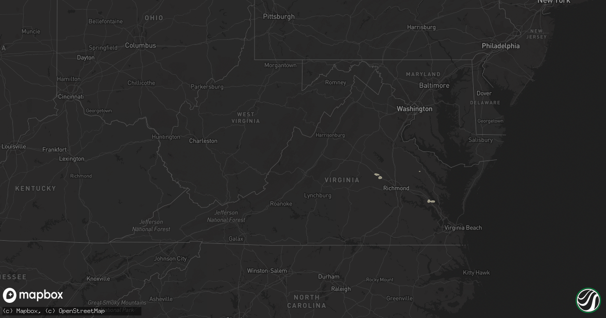
Hail Map in Virginia on July 29, 2022
Get this storm
July 29 map
$229
one time, instant access
Download today. No call, no setup
Keep the $229
Bought the map and want the full workflow? Apply the entire $229 to a subscription within 7 days. None of it is wasted.
Every map, not just this one
This buys you this map. Subscription and you get every map we run, in the markets you choose from a few cities to whole states to nationwide. Plus real-time alerts the moment a storm fires.
Contact data
Name, contact info, occupancy, even credit band for addresses in the footprint. You go from where it hit to who to call.
Become the source they trust
Unlimited branding weather history reports on demand. You already have the documented answer ready for the property owner, and you are the one who showed up with it.
Property data and RoofTrace estimates
Pull up any address you have got, its value and the exact code rules for that jurisdiction, straight from One Click Code. Then RoofTrace estimates the squares, pitch, and roof value, priced the way you price.
Storm reports in Virginia
Virginia
| Date | Description |
|---|---|
| 07/29/20224:55 PM CDT | Sandbridge wxflow site. |
| 07/29/20224:17 PM CDT | Powerlines down. |
| 07/29/20223:25 PM CDT | Trees downed on eagle point plantation rd at warner hall rd. |
| 07/29/20223:05 PM CDT | Downed tree blocking roadway. Time estimated. |
| 07/29/20222:45 PM CDT | Road blocked by downed tree. Time estimated. |
| 07/29/20221:45 PM CDT | Downed trees knocked over powerlines. Time estimated. |
| 07/29/20221:40 PM CDT | Tree on powerline near st stephens church in king and queen county. Time estimated. |
| 07/29/20221:30 PM CDT | Vdot reports downed tree blocking road. Time estimated. |
| 07/29/20221:20 PM CDT | Henrico police reports downed tree blocking road. |
| 07/29/202212:50 PM CDT | Road blocked by downed tree. Time estimated. |
| 07/29/202212:50 PM CDT | Road blocked by downed tree. Time estimated. |
| 07/29/202212:30 PM CDT | Two trees down on top of powerline. Time estimated from radar. |
| 07/28/202211:23 PM CDT | At 422 PM EDT, severe thunderstorms were located along a line extending from near Tangier to 10 miles northwest of Exmore to 11 miles east of Gwynn, moving east at 25 mph. HAZARD...60 mph wind gusts. SOURCE...Radar indicated. IMPACT...Expect damage to trees and powerlines. Severe thunderstorms will be near... Onancock and Nassawadox around 450 PM EDT. Exmore, Onley and Willis Wharf around 455 PM EDT. Parksley around 505 PM EDT.Other locations impacted by these severe thunderstorms includeHallwood, Harborton, Melfa, Mappsville, Jamesville, Silver Beach,Wachapreague, Wardtown, Franktown and Accomac. |
| 07/28/202211:15 PM CDT | At 415 PM EDT, a severe thunderstorm was located near Queens Lake, moving east at 30 mph. HAZARD...60 mph wind gusts and penny size hail. SOURCE...Radar indicated. IMPACT...Expect damage to trees and powerlines. This severe thunderstorm will be near... Gloucester Courthouse, Gloucester Point, Virginia Institute For Marine Sciences, Wicomico and Hayes around 425 PM EDT. Achilles around 430 PM EDT. Mobjack around 445 PM EDT. Mathews and Bavon around 450 PM EDT.Other locations impacted by this severe thunderstorm include Ruff,Beulah, Moon, Laban, Camp Peary, Glass, Naxera, Allmondsville, ClayBank and Port Haywood. |
| 07/28/202210:56 PM CDT | At 356 PM EDT, severe thunderstorms were located along a line extending from near Powhatan to near Amelia Courthouse to near Rice, moving east at 35 mph. HAZARD...60 mph wind gusts. SOURCE...Radar indicated. IMPACT...Expect damage to trees and powerlines. Severe thunderstorms will be near... Powhatan, Amelia Courthouse and Macon around 400 PM EDT. Chula around 405 PM EDT. Scotts Fork around 410 PM EDT. Moseley, Sabot and Manakin around 415 PM EDT. Tuckahoe around 420 PM EDT. Bon Air and Mannboro around 435 PM EDT.Other locations impacted by these severe thunderstorms include RockCastle, Pilkinton, Winterham, Skinquarter, Maplewood, Fine CreekMills, Deatonville, Holly Hills, Lodore and Lake Powhatan. |
| 07/28/20229:31 PM CDT | At 231 PM EDT, severe thunderstorms were located along a line extending from near Champlain to Manquin, moving northeast at 25 mph. HAZARD...60 mph wind gusts. SOURCE...Radar indicated. IMPACT...Expect damage to trees and powerlines. Severe thunderstorms will be near... Tappahannock around 245 PM EDT. Stevensville around 255 PM EDT. Warsaw and Millers Tavern around 300 PM EDT. Haynesville around 310 PM EDT. Center Cross, Hague, Dunnsville and Sharps around 315 PM EDT.Other locations impacted by these severe thunderstorms includeThreeway, Upright, Ino, Biscoe, Tidewater, Lyells, Crouch, Kennard,Mount Landing and Piney Grove. |
| 07/28/20229:11 PM CDT | At 209 PM EDT, severe thunderstorms were located along a line extending from Kings Dominion to near Tuckahoe, moving east at 35 mph. HAZARD...60 mph wind gusts. SOURCE...Radar indicated. IMPACT...Expect damage to trees and powerlines. Severe thunderstorms will be near... Kings Dominion around 215 PM EDT. Hanover, Dawn and East Highland Park around 220 PM EDT. Highland Springs, Mechanicsville and Mangohick around 225 PM EDT. Beulahville and Studley around 235 PM EDT. Aylett and Manquin around 240 PM EDT. Saint Stephens Church around 250 PM EDT.Other locations impacted by these severe thunderstorms includeEnfield, Central Garage, Hanover Airport, Gum Tree, Upshaw, Elmont,Etna Mills, Longdale, Epworth and Westwood. |
| 07/28/20228:25 PM CDT | At 125 PM EDT, a severe thunderstorm was located over Gum Spring, or near Goochland, moving east at 35 mph. HAZARD...60 mph wind gusts and penny size hail. SOURCE...Radar indicated. IMPACT...Expect damage to trees and powerlines. This severe thunderstorm will be near... Oilville around 135 PM EDT. Montpelier around 145 PM EDT. Tuckahoe and Wyndham around 150 PM EDT. Ashland, Randolph Macon College, Glen Allen and Laurel around 205 PM EDT.Other locations impacted by this severe thunderstorm include Orchid,Crozier, Sandy Hook, Vontay, Maidens, Gum Tree, Three Square, Irwin,Johnsons Springs and Goodall. |
All States Impacted by Hail Map on July 29, 2022
Cities Impacted by Hail Map on July 29, 2022
- Pendroy, MT
- Bynum, MT
- Joliet, MT
- Dunnsville, VA
- Tappahannock, VA
- Dumas, TX
- Mescalero, NM
- Crossville, AL
- Lockney, TX
- Sparkman, AR
- Canyon, TX
- Happy, TX
- Iowa Park, TX
- Wichita Falls, TX
- Cape Coral, FL
- Breckenridge, TX
- Edgemont, SD
- Amarillo, TX
- Rapid City, SD
- Big Timber, MT
- Lusk, WY
- Floydada, TX
- Williamsburg, VA
- Claude, TX
- Clarendon, TX
- Nara Visa, NM
- Groveoak, AL
- Panhandle, TX
- Trementina, NM
- Hereford, TX
- Oelrichs, SD
- Jay Em, WY
- Harrison, NE
- Hedley, TX
- Seymour, TX
- Clayton, NM
- Grenville, NM
- Sandy Hook, VA
- Bumpass, VA
- Gum Spring, VA
- Maidens, VA
- Mineral, VA
- Pampa, TX
- Hill City, SD
- Raynesford, MT
- Silverton, TX
- Jefferson, GA
- Glendo, WY
- Hartville, WY
- Gallup, NM
- Chester, SC
- Blackstock, SC
- Skellytown, TX
- White Deer, TX
- Columbus, MT
- Dawson, AL
- Collinsville, AL
- Guntersville, AL
- Albertville, AL
- Fort Payne, AL
- Scottsboro, AL
- Watson, OK
- Arkadelphia, AR
- Cascade, MT
- Bethune, SC
- Littlefield, AZ
- Kingman, AZ
- Elberton, GA
- Fyffe, AL
- Geraldine, AL
- Buffalo Gap, SD
- Fairburn, SD
- Wheatland, WY
- Amistad, NM
- Rockville, VA
- Crozier, VA
- Manakin Sabot, VA
- Oilville, VA
- Groom, TX
- Fort Benton, MT
- Boswell, OK
- Tremont, MS
- Hamilton, AL
- Vega, TX
- Forestburg, TX
- Kress, TX
- Plainview, TX
- Saint George, UT
- Lakeview, TX
- Bokeelia, FL
- Belzoni, MS
- Ringling, OK
- Wilson, OK
- Fouke, AR
- Texarkana, AR
- Logan, NM
- Tucumcari, NM
- Mosquero, NM
- Lexington, MS
- Keithville, LA
- Ryan, OK
- Naples, FL
- Coila, MS
- Saint Jo, TX
- Choteau, MT
- Crawford, NE
- San Jon, NM


