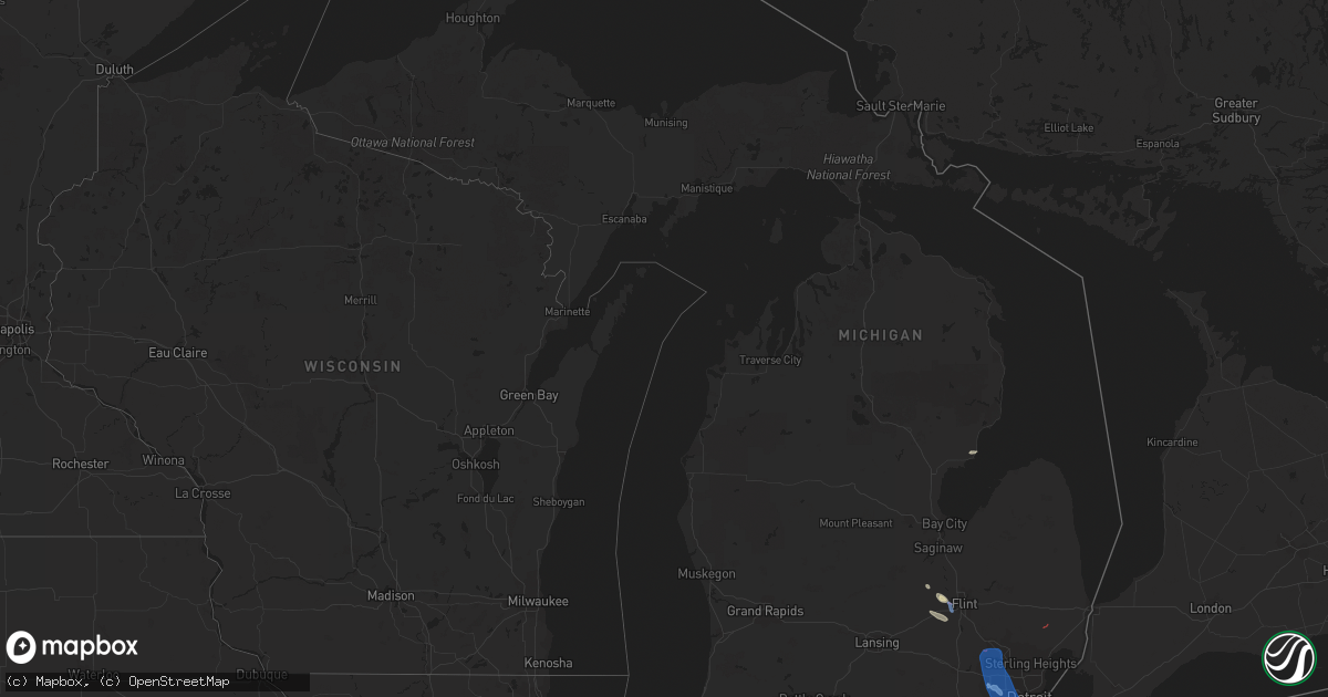
Hail Map in Michigan on July 24, 2021
Get this storm
July 24 map
$229
one time, instant access
Download today. No call, no setup
Keep the $229
Bought the map and want the full workflow? Apply the entire $229 to a subscription within 7 days. None of it is wasted.
Every map, not just this one
This buys you this map. Subscription and you get every map we run, in the markets you choose from a few cities to whole states to nationwide. Plus real-time alerts the moment a storm fires.
Contact data
Name, contact info, occupancy, even credit band for addresses in the footprint. You go from where it hit to who to call.
Become the source they trust
Unlimited branding weather history reports on demand. You already have the documented answer ready for the property owner, and you are the one who showed up with it.
Property data and RoofTrace estimates
Pull up any address you have got, its value and the exact code rules for that jurisdiction, straight from One Click Code. Then RoofTrace estimates the squares, pitch, and roof value, priced the way you price.
Storm reports in Michigan
Michigan
| Date | Description |
|---|---|
| 07/24/20216:54 PM CDT | *** 1 inj *** ef-1 tornado confirmed via nws storm survey. Winds estimated to 100 mph... With path width of 400 yards and path length of 1.8 miles. Tornado was on groun |
| 07/24/20216:52 PM CDT | Numerous trees reported down across indian springs metropark. |
| 07/24/20216:26 PM CDT | Tree on roadway. |
| 07/24/20216:25 PM CDT | Large tree branches down and house was shaking from the wind. |
| 07/24/20216:20 PM CDT | Tree limbs down. |
| 07/24/20216:19 PM CDT | Trees and power lines down in multiple locations across charlotte... Michigan. |
| 07/24/20216:18 PM CDT | Large section of tree snapped near i-96 and martin luther king blvd. Time estimated from radar. Additional reports and photos of very large limbs down have been receive |
| 07/24/20215:27 PM CDT | Reports of several large limbs down near m-21 and morrish road. |
| 07/24/20215:24 PM CDT | Report of multiple trees down and building damage |
| 07/24/20215:23 PM CDT | Siding and roof of residential home torn off. Photos sent via twitter |
| 07/24/20215:22 PM CDT | Report of a destroyed barn via photo on calkins and morrish rd |
| 07/24/20215:03 PM CDT | Tree blocking road of 8th and byron avenue. |
| 07/24/20214:56 PM CDT | 3 trees down across road. |
| 07/24/20214:54 PM CDT | Power line reported down in a field in drenthe... Mi. |
| 07/24/20214:53 PM CDT | Tree blocking road. |
| 07/24/20214:50 PM CDT | Power lines down. |
| 07/24/20214:50 PM CDT | Trees and powers lines down. |
| 07/24/20214:45 PM CDT | Dispatch reports downed wires at ormes and bray rd |
| 07/24/20214:40 PM CDT | Dispatch reports tree down on kelly and englehart rd |
| 07/24/20214:14 PM CDT | Dispatch reports several large tree limbs and power lines down in the city of saginaw. |
| 07/24/20213:45 PM CDT | 12 to 14 inch diameter tree down. Relayed via social media photo. |
| 07/24/20213:36 PM CDT | Large tree limb snapped reported via social media photo. |
| 07/24/20213:34 PM CDT | Several reports and social media photo of tornado on ground near port austin. |
| 07/24/20213:28 PM CDT | Several trees down in washington avenue park. Social media pictures included uprooted trees and a blown over portable toilet. |
| 07/24/20213:25 PM CDT | Reports of several trees and powerlines down |
| 07/24/20213:17 PM CDT | Report of a tree down on anderson rd and mackinaw rd |
| 07/24/20213:07 PM CDT | Reports of several trees and powerlines down in larkin twp |
| 07/24/20213:03 PM CDT | Multiple reports of down trees and power lines down |
| 07/24/20214:41 AM CDT | At 940 PM EDT, a line of severe thunderstorms were located from Hudson to Britton moving southeast at 40 mph. HAZARD...60 mph wind gusts. SOURCE...Radar indicated. IMPACT...Expect damage to roofs, siding, and trees. This severe thunderstorm will remain over mainly rural areas of Lenawee County, including the following locations... Seneca, Lime Creek, Munson, Ogden Center, Canandaigua, Ridgeway, Palmyra, Sand Creek, Rome Center and Jasper.People attending Lenawee County Fairgrounds should seek safe shelterimmediately! |
| 07/24/20214:30 AM CDT | At 930 PM EDT, a severe thunderstorm was located over Flat Rock, moving southeast at 35 mph. HAZARD...60 mph wind gusts. SOURCE...Radar indicated. IMPACT...Expect damage to roofs, siding, and trees. This severe thunderstorm will remain over mainly rural areas of south central Wayne County, including the following locations... Brownstown Township, Gibraltar, Allen Park, Woodhaven, Lincoln Park, Riverview, Rockwood, Southgate, South Rockwood and Melvindale. |
| 07/24/20213:50 AM CDT | At 849 PM EDT, a line of severe thunderstorms were located from Hanover to Saline moving southeast at 35 mph. HAZARD...60 mph wind gusts. SOURCE...Radar indicated. IMPACT...Expect damage to roofs, siding, and trees. Locations impacted include... Manchester, Onsted, Adrian, Tecumseh, Britton, Blissfield and Deerfield.People attending Lenawee County Fairgrounds should seek safe shelterimmediately! |
| 07/24/20213:41 AM CDT | At 841 PM EDT, severe thunderstorms were located along a line extending from near Vandercook Lake to 5 miles northeast of Litchfield, moving east at 50 mph. HAZARD...60 mph wind gusts. SOURCE...Radar indicated. IMPACT...Expect damage to roofs, siding, and trees. Locations impacted include... Jackson... Brooklyn... Vandercook Lake... Spring Arbor... Napoleon... Norvell... Pulaski... Concord... Horton... Hanover... Oak Point... Sunset Beach... Michigan Center... |
| 07/24/20213:14 AM CDT | At 814 PM EDT, severe thunderstorms were located along a line extending from near Mount Clemens to near Brighton, moving southeast at 35 mph. HAZARD...70 mph wind gusts. SOURCE...Radar indicated. IMPACT...Expect considerable tree damage. Damage is likely to mobile homes, roofs, and outbuildings. Locations impacted include... Northville, Canton, Romulus, Taylor, Greenfield Village, Flat Rock, Wyandotte, Trenton and Grosse Ile.People attending Comerica Park should seek safe shelter immediately! |
| 07/24/20213:07 AM CDT | At 806 PM EDT, a severe thunderstorm was located 7 miles north of Burlington, or 8 miles southwest of Marshall, moving east at 30 mph. HAZARD...60 mph wind gusts. SOURCE...Radar indicated. IMPACT...Expect damage to roofs, siding, and trees. Locations impacted include... Albion... Marshall... Battle Creek... Homer... Union City... Burlington... Brownlee Park... Marengo... Athens... Tekonsha... Pine Creek... Ceresco... |
| 07/24/20213:01 AM CDT | At 800 PM EDT, a severe thunderstorm was located over Rochester, or 7 miles north of Troy, moving southeast at 25 mph. HAZARD...60 mph wind gusts. SOURCE...Radar indicated. IMPACT...Expect damage to roofs, siding, and trees. This severe thunderstorm will be near... Warren and Sterling Heights around 820 PM EDT.Other locations in the path of this severe thunderstorm includeMacomb Township, Mount Clemens and St. Clair Shores.People attending Jimmy John Field should seek safe shelterimmediately! |
| 07/24/20212:49 AM CDT | At 748 PM EDT, severe thunderstorms were located along a line extending from near Elkhart to near Walkerton, moving southeast at 35 mph. HAZARD...60 mph wind gusts. SOURCE...Radar indicated. IMPACT...Expect damage to roofs, siding, and trees. Locations impacted include... South Bend, Elkhart, Mishawaka, Goshen, Warsaw, Nappanee, Bremen, Syracuse, Dunlap, Simonton Lake, Gulivoire Park, Granger, Middlebury, Osceola, Bourbon, Wakarusa, Bristol, Milford, North Webster and Millersburg.This includes Interstate 80 in Indiana between mile markers 88 and107. |
| 07/24/20212:48 AM CDT | At 748 PM EDT, severe thunderstorms were located along a line extending from near Elkhart to near Walkerton, moving southeast at 35 mph. HAZARD...60 mph wind gusts. SOURCE...Radar indicated. IMPACT...Expect damage to roofs, siding, and trees. Locations impacted include... South Bend, Elkhart, Mishawaka, Goshen, Warsaw, Nappanee, Bremen, Syracuse, Dunlap, Simonton Lake, Gulivoire Park, Granger, Middlebury, Osceola, Bourbon, Wakarusa, Bristol, Milford, North Webster and Millersburg.This includes Interstate 80 in Indiana between mile markers 88 and107. |
| 07/24/20212:40 AM CDT | At 739 PM EDT, a line of severe thunderstorms were located from Webberville to Lake Orion moving southeast at 25 mph. HAZARD...60 mph wind gusts. SOURCE...Radar indicated. IMPACT...Expect damage to roofs, siding, and trees. Locations impacted include... Milford, Novi, West Bloomfield and Northville.People attending Eddies Christmas in July Fireworks Show should seeksafe shelter immediately! |
| 07/24/20212:17 AM CDT | At 717 PM EDT, severe thunderstorms were located along a line extending from near Potterville to near Bellevue, moving east at 45 mph. HAZARD...60 mph wind gusts. SOURCE...Radar indicated. IMPACT...Expect damage to roofs, siding, and trees. Locations impacted include... Charlotte... Mason... Eaton Rapids... Potterville... Leslie... Bellevue... Stockbridge... Aurelius... Onondaga... Bunker Hill... Olivet... Brookfield... Dimondale... Dansville... Eden... Fitchburg... Holt... Gresham... |
| 07/24/20211:58 AM CDT | At 658 PM EDT, a severe thunderstorm was located near Grand Ledge, or 8 miles northwest of Lansing, moving east at 45 mph. HAZARD...60 mph wind gusts. SOURCE...Radar indicated. IMPACT...Expect damage to roofs, siding, and trees. Locations impacted include... Lansing... East Lansing... Grand Ledge... Williamston... Edgemont Park... DeWitt... Webberville... Waverly... Eagle... Wacousta... Okemos... Bath... Bell Oak... Haslett... Holt... |
| 07/24/20211:43 AM CDT | At 642 PM EDT, a severe thunderstorm was located over Lapeer, moving southeast at 35 mph. HAZARD...60 mph wind gusts. SOURCE...Radar indicated. IMPACT...Expect damage to roofs, siding, and trees. This severe thunderstorm will be near... Imlay City around 700 PM EDT.Other locations in the path of this severe thunderstorm includeDryden and Almont. |
| 07/24/20211:11 AM CDT | At 610 PM EDT, a line of severe thunderstorms were located New Lothrop to Otter Lake moving southeast at 25 mph. HAZARD...60 mph wind gusts. SOURCE...Radar indicated. IMPACT...Expect damage to roofs, siding, and trees. This severe thunderstorm will be near... Burton around 620 PM EDT. Davison around 625 PM EDT.Other locations in the path of this severe thunderstorm include GrandBlanc, Goodrich and Hadley. |
| 07/24/20211:06 AM CDT | At 605 PM EDT, a severe thunderstorm was located near New Lothrop, moving east at 40 mph. HAZARD...60 mph wind gusts. SOURCE...Radar indicated. IMPACT...Expect damage to roofs, siding, and trees. This severe thunderstorm will be near... New Lothrop around 610 PM EDT. Durand and Lennon around 615 PM EDT. |
| 07/24/202112:50 AM CDT | At 550 PM EDT, a severe thunderstorm was located near Hudsonville, or 11 miles southwest of Grand Rapids, moving east at 40 mph. HAZARD...60 mph wind gusts. SOURCE...Radar indicated. IMPACT...Expect damage to roofs, siding, and trees. Locations impacted include... Grand Rapids... Holland... Hastings... Lowell... Wyoming... Kentwood... Walker... Grandville... East Grand Rapids... Hudsonville... Zeeland... Wayland... Middleville... Caledonia... Saugatuck... Freeport... Beechwood... Jenison... Dorr... Irving... |
| 07/24/202112:49 AM CDT | At 549 PM EDT, a severe thunderstorm was located 7 miles southwest of Argyle, or 7 miles southeast of Cass City, moving east at 40 mph. HAZARD...60 mph wind gusts. SOURCE...Radar indicated. IMPACT...Expect damage to roofs, siding, and trees. This severe thunderstorm will be near... Argyle around 600 PM EDT.Other locations in the path of this severe thunderstorm includeSandusky, Deckerville and Carsonville. |
| 07/24/202112:23 AM CDT | At 522 PM EDT, a line of severe thunderstorms were located from Reese to Unionville, moving southeast at 35 mph. HAZARD...60 mph wind gusts. SOURCE...Radar indicated. IMPACT...Expect damage to roofs, siding, and trees. Locations impacted include... Kingston. |
| 07/24/202112:11 AM CDT | At 510 PM EDT, a line of severe thunderstorms were located from Marion Springs to Quanicassee moving southeast at 35 mph. HAZARD...60 mph wind gusts. SOURCE...Radar indicated. IMPACT...Expect damage to roofs, siding, and trees. Locations impacted include... Clio, Millington, Otisville, Otter Lake, Columbiaville, Lapeer and Lum. |
| 07/23/202111:57 PM CDT | At 457 PM EDT, severe thunderstorms were located along a line extending from near Quanicassee to 8 miles southeast of Ithaca, moving southeast at 40 mph. HAZARD...60 mph wind gusts. SOURCE...Radar indicated. IMPACT...Expect damage to roofs, siding, and trees. Severe thunderstorms will be near... Munger around 505 PM EDT.Other locations in the path of these severe thunderstorms includeOakley. |
| 07/23/202111:38 PM CDT | At 438 PM EDT, a severe thunderstorm was located 7 miles west of Ithaca, moving east at 35 mph. HAZARD...60 mph wind gusts. SOURCE...Radar indicated. IMPACT...Expect damage to roofs, siding, and trees. Locations impacted include... Ithaca... Sumner... North Star... Ashley... Perrinton... Pompeii... Bannister... |
| 07/23/202111:37 PM CDT | At 437 PM EDT, a severe thunderstorm was located 8 miles north of Quanicassee, or 11 miles northeast of Bay City, moving east at 45 mph. HAZARD...60 mph wind gusts and penny size hail. SOURCE...Radar indicated. IMPACT...Expect damage to roofs, siding, and trees. This severe thunderstorm will be near... Quanicassee around 440 PM EDT. Sebewaing, Akron and Unionville around 455 PM EDT.Other locations in the path of this severe thunderstorm includeOwendale, Gagetown and Cass City. |
| 07/23/202111:08 PM CDT | At 408 PM EDT, a severe thunderstorm was located near Port Austin, moving east at 35 mph. HAZARD...60 mph wind gusts. SOURCE...Radar indicated. IMPACT...Expect damage to roofs, siding, and trees. This severe thunderstorm will be near... Port Austin around 415 PM EDT. Kinde around 420 PM EDT.Other locations in the path of this severe thunderstorm include PortHope. |
| 07/23/202111:03 PM CDT | At 402 PM EDT, severe thunderstorms were located along a line extending from near Rhodes to 6 miles southwest of Mount Pleasant, moving east-southeast at 35 mph. HAZARD...60 mph wind gusts and penny size hail. SOURCE...Radar indicated. IMPACT...Expect damage to roofs, siding, and trees. Locations impacted include... Pleasant Valley and Merrill. |
| 07/23/202110:38 PM CDT | At 338 PM EDT, a severe thunderstorm was located near Beaverton, or near Gladwin, moving east at 35 mph. HAZARD...60 mph wind gusts and penny size hail. SOURCE...Radar indicated. IMPACT...Expect damage to roofs, siding, and trees. Locations impacted include... Bentley and Pinconning. |
| 07/23/202110:21 PM CDT | At 320 PM EDT, a severe thunderstorm was located 8 miles west of Beaverton, or 8 miles northeast of Clare, moving east at 30 mph. HAZARD...60 mph wind gusts and penny size hail. SOURCE...Radar indicated. IMPACT...Expect damage to roofs, siding, and trees. This severe thunderstorm will be near... Gladwin and Beaverton around 335 PM EDT.Other locations in the path of this severe thunderstorm includeWinegars, Wooden Shoe Village and Rhodes. |
| 07/23/202110:16 PM CDT | At 315 PM EDT, a severe thunderstorm was located near Au Gres, moving east at 30 mph. HAZARD...60 mph wind gusts and quarter size hail. SOURCE...Radar indicated. IMPACT...Hail damage to vehicles is expected. Expect wind damage to roofs, siding, and trees. This severe thunderstorm will remain over mainly rural areas of northeastern Arenac County. |
| 07/23/20219:58 PM CDT | At 257 PM EDT, a severe thunderstorm was located 6 miles southwest of Harrison, or 9 miles northwest of Clare, moving east at 40 mph. HAZARD...60 mph wind gusts. SOURCE...Radar indicated. IMPACT...Expect damage to roofs, siding, and trees. Locations impacted include... Clare... Farwell... Harrison... Lake... Lake George... |
| 07/23/20218:13 PM CDT | Numerous reports of tree damage at the willow metropark golf course. |
| 07/23/20217:55 PM CDT | Large tree limb down across road near moon rd and west willis rd. Reported via social media photo. |
| 07/23/20217:43 PM CDT | Damage to a gas station at the intersection of w lincoln ave and and john r.road. Time estimated based on radar. |
| 07/23/20217:33 PM CDT | Large tree limb down near 9 mile and telegraph rd. Photo relayed via social media. |
| 07/23/20217:19 PM CDT | Measured via west bloomfield mesonet. |
| 07/23/20217:19 PM CDT | Reports of multiple trees and power lines down near south commerce and wolverine lake. |
| 07/23/20217:12 PM CDT | Reports of large oak trees down on residential homes. |
| 07/23/20217:11 PM CDT | Measured by ptk asos. |
| 07/23/20217:09 PM CDT | Tree across road at l drive and 19 mile road. |
| 07/23/20217:09 PM CDT | Trees and power lines down. |
| 07/23/20217:02 PM CDT | Several trees down over maceday lake road. Large tree also fell onto a home less than a mile east of williams lake road market on williams lake road. Time estimated bas |
| 07/23/20217:01 PM CDT | Reported tornado near oxbow lake. Damage to cottage. |
| 07/23/20217:01 PM CDT | Multiple trees snapped or sheared off and powerlines down over road on intersection of armada center and spencer rd. Photos sent via twitter. |
All States Impacted by Hail Map on July 24, 2021
Cities Impacted by Hail Map on July 24, 2021
- Arapahoe, NE
- Cambridge, NE
- Eustis, NE
- Bertrand, NE
- Oxford, NE
- Edison, NE
- Holbrook, NE
- Elwood, NE
- Ganado, AZ
- Redvale, CO
- Hotevilla, AZ
- Albany, MO
- Bladen, NE
- Ayr, NE
- Blue Hill, NE
- Newark, MO
- Novelty, MO
- Guide Rock, NE
- Belleville, KS
- Peotone, IL
- Frankfort, IL
- Monee, IL
- Hollenberg, KS
- Saint George, UT
- Pinon, AZ
- Fairbury, NE
- Veyo, UT
- Lawrence, NE
- Roseland, NE
- Caliente, NV
- Bloomfield, NM
- Fence Lake, NM
- Gallup, NM
- Manhattan, IL
- New Lenox, IL
- Vermillion, KS
- Kaibeto, AZ
- Kayenta, AZ
- Polacca, AZ
- Saint Anne, IL
- Pembroke Township, IL
- Funk, NE
- Nucla, CO
- Redford, MI
- Dearborn Heights, MI
- Westland, MI
- Livonia, MI
- Placerville, CO
- Endicott, NE
- Washington, KS
- Bremen, KS
- Hanover, KS
- Peach Springs, AZ
- Orleans, NE
- Stamford, NE
- Lewistown, IL
- Ipava, IL
- Bethel, MO
- Williams, AZ
- Woodston, KS
- Long Island, KS
- Holdrege, NE
- New Lothrop, MI
- Chesaning, MI
- Owosso, MI
- Hardy, NE
- Fort Stockton, TX
- Norwood, CO
- Republic, KS
- Rockville, IN
- Hebron, NE
- Chester, NE
- Hildale, UT
- Colorado City, AZ
- Flushing, MI
- Corunna, MI
- Lennon, MI
- Ewing, MO
- La Belle, MO
- Keams Canyon, AZ
- Bedrock, CO
- Frankfort, KS
- Camden, IL
- Huntsville, IL
- Plymouth, IL
- Grants, NM
- Axtell, NE
- Durand, MI
- Gaines, MI
- Swartz Creek, MI
- Deshler, NE
- Naturita, CO
- Wilcox, NE
- Marshall, IN
- La Crosse, IN
- Wanatah, IN
- Superior, NE
- Beattie, KS
- Summerfield, KS
- Cuba, KS
- Farmington, NM
- Rutledge, MO
- Burr Oak, KS
- Campbell, NE
- Red Cloud, NE
- Holstein, NE
- Fort Davis, TX
- Centralia, KS
- Deerfield Beach, FL
- Boca Raton, FL
- Westville, IN
- Union Mills, IN
- Valparaiso, IN
- Chesterton, IN
- Michigan City, IN
- Esbon, KS
- Burbank, IL
- Chicago, IL
- Unionville, MO
- Au Gres, MI
- La Grange, IL
- Bridgeview, IL
- Summit Argo, IL
- Justice, IL
- Plymouth, MI
- Northville, MI
- Palatine, IL
- Hoffman Estates, IL
- Barrington, IL
- Stanton, TX
- Shonto, AZ
- Paradox, CO
- Flint, MI
- South Rockwood, MI
- River Rouge, MI
- Carleton, MI
- Riverview, MI
- Detroit, MI
- Novi, MI
- Southfield, MI
- Romulus, MI
- Wixom, MI
- Lincoln Park, MI
- Keego Harbor, MI
- Canton, MI
- Wyandotte, MI
- Waterford, MI
- White Lake, MI
- New Boston, MI
- Melvindale, MI
- Flat Rock, MI
- Trenton, MI
- Taylor, MI
- Southgate, MI
- Inkster, MI
- Grosse Ile, MI
- Allen Park, MI
- Rockwood, MI
- Walled Lake, MI
- Garden City, MI
- Ecorse, MI
- Farmington, MI
- Dearborn, MI
- West Bloomfield, MI
- Commerce Township, MI
- Wayne, MI
- Pontiac, MI
- Bloomfield Hills, MI
- Franklin, MI
- Armada, MI
- Munster, IN
- Whiting, IN
- Hobart, IN
- Hammond, IN
- Griffith, IN
- La Porte, IN
- Gary, IN
- Portage, IN
- Lake Station, IN
- East Chicago, IN
- Highland, IN


