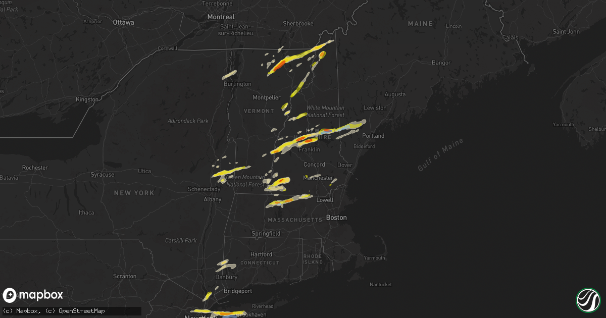
Hail Map in Vermont on July 21, 2022
Get this storm
July 21 map
$229
one time, instant access
Download today. No call, no setup
Keep the $229
Bought the map and want the full workflow? Apply the entire $229 to a subscription within 7 days. None of it is wasted.
Every map, not just this one
This buys you this map. Subscription and you get every map we run, in the markets you choose from a few cities to whole states to nationwide. Plus real-time alerts the moment a storm fires.
Contact data
Name, contact info, occupancy, even credit band for addresses in the footprint. You go from where it hit to who to call.
Become the source they trust
Unlimited branding weather history reports on demand. You already have the documented answer ready for the property owner, and you are the one who showed up with it.
Property data and RoofTrace estimates
Pull up any address you have got, its value and the exact code rules for that jurisdiction, straight from One Click Code. Then RoofTrace estimates the squares, pitch, and roof value, priced the way you price.
Storm reports in Vermont
Vermont
| Date | Description |
|---|---|
| 07/21/20225:22 PM CDT | Tree down on wires. |
| 07/21/20224:55 PM CDT | 1 large tree down on lines and numerous other small limbs throughout brighton state park. |
| 07/21/20223:59 PM CDT | Trees and power lines down in brandon... Whiting... And leicester. |
| 07/21/20223:48 PM CDT | Powerlines down on route 73 |
| 07/21/20223:45 PM CDT | Trees down on route 22a |
| 07/21/20223:09 PM CDT | Trees down on mayo rd. Time estimated by radar. |
| 07/21/20223:05 PM CDT | Tree down... Time estimated by radar. |
| 07/21/20222:57 PM CDT | Tree down... Time estimated by radar. |
| 07/21/20222:52 PM CDT | Trees and wires down in monkon ridge area. |
| 07/21/20222:45 PM CDT | Reports of snapped trees along greenbush rd. |
| 07/21/20222:45 PM CDT | Tree downed near route 7 on the charlotte and ferrisburg town line. |
| 07/21/20221:54 PM CDT | Trees down |
| 07/21/20221:45 PM CDT | Report of a snapped pine tree at a residence on eastern side of newark. |
| 07/21/20221:18 PM CDT | Trees and wires down in waterford area |
| 07/21/20221:16 PM CDT | Tree on power lines causing outage in concord and waterford areas. |
| 07/21/20221:16 PM CDT | Tree on p |
| 07/21/202212:54 PM CDT | A local report indicates 1.00 inch wind near 2 NNW BRADFORD |
| 07/21/202212:51 PM CDT | Trees and power lines down |
| 07/21/202212:46 PM CDT | Numerous large trees down on tenney pond road |
| 07/21/202212:45 PM CDT | 1 tree down in southern portion of manchester and small hail in the mid portion of manchester |
| 07/21/202212:42 PM CDT | Estimated quarter size hail. Time estimated from radar. |
| 07/21/202212:38 PM CDT | Tree down on power lines |
| 07/21/202212:30 PM CDT | Large tree bran |
| 07/21/202212:30 PM CDT | Large tree branch on route 104 between fairfax and cambridge |
| 07/21/202212:15 PM CDT | Trees and power lines down |
| 07/21/202212:08 PM CDT | A local report indicates 1.00 inch wind near 5 W ISLAND POND |
| 07/21/202212:06 PM CDT | A dozen large trees down on route 105. |
| 07/21/202211:50 AM CDT | A local report indicates 1.75 inch wind near IRASBURG |
| 07/21/202211:50 AM CDT | A local report indicates 1.75 inch wind near ORLEANS |
| 07/21/202211:48 AM CDT | Large trees blocking lake region road... Just west of i-91. |
| 07/21/202211:38 AM CDT | A local report indicates 1.25 inch wind near ALBANY |
| 07/21/202211:34 AM CDT | A local report indicates 1.00 inch wind near ALBANY |
| 07/21/202211:11 AM CDT | Tree down in east fairfield and pea size hail. |
| 07/21/20227:42 AM CDT | At 1242 PM EDT, a severe thunderstorm was located near Hartford, or 7 miles east of Hudson Falls, moving east at 35 mph. HAZARD...60 mph wind gusts and quarter size hail. SOURCE...Radar indicated. IMPACT...Hail damage to vehicles is expected. Expect wind damage to roofs, siding, and trees. Locations impacted include... Granville, Hartford, Dorset, Kingsbury, Porter, Rupert, Fort Ann, Argyle, Middle Granville, Braymer School, Smiths Basin, Goose Island, Adamsville, North Granville, East Hebron, South Granville, Truthville, Tiplady, Raceville and West Pawlet. |
| 07/21/20227:32 AM CDT | At 1232 PM EDT, a severe thunderstorm was located near Saratoga Springs, moving northeast at 30 mph. HAZARD...60 mph wind gusts and quarter size hail. SOURCE...Radar indicated. IMPACT...Hail damage to vehicles is expected. Expect wind damage to roofs, siding, and trees. Locations impacted include... Saratoga Springs, Ballston Spa, Cambridge, Greenwich, Round Lake, North Ballston Spa, Gates, Malta, Northumberland, Easton, Stillwater, Schuylerville, Victory, Deans Corners, Center Falls, Grangerville, Wayville, Middle Falls, North Cambridge and Halls Corner. |
| 07/21/20227:29 AM CDT | At 1229 PM EDT, a severe thunderstorm was located over West Hill, moving northeast at 30 mph. HAZARD...60 mph wind gusts and quarter size hail. SOURCE...Radar indicated. IMPACT...Minor hail damage to vehicles is possible. Expect wind damage to trees and powerlines. Locations impacted include... Newport City, Enosburg Falls, Waterville, Jay, Newport Town, Jay In Franklin County, Bakersfield, Westfield, Newport Center, North Troy Village, Montgomery Center, Richford, Montgomery, Enosburg Falls Village, Troy, Belvidere Center, Enosburg, Belvidere, Berkshire and Derby Line Village. |
| 07/21/20227:09 AM CDT | At 1209 PM EDT, a severe thunderstorm was located over Morrisville Village, moving northeast at 30 mph. HAZARD...60 mph wind gusts and quarter size hail. SOURCE...Radar indicated. IMPACT...Minor hail damage to vehicles is possible. Expect wind damage to trees and powerlines. Locations impacted include... Newport City, Lyndon, St. Johnsbury, Morrisville, Orleans, Greensboro, Johnson Village, Eden, Stannard, Orleans Village, Glover, Hardwick, Brownington, Albany, Hyde Park, Sutton, Wolcott, Coventry, Barton and Greensboro Bend. |
| 07/20/202211:27 PM CDT | At 427 PM EDT, a severe thunderstorm was located over Black Point, moving east at 35 mph. HAZARD...60 mph wind gusts and quarter size hail. SOURCE...Radar indicated. IMPACT...Minor hail damage to vehicles is possible. Expect wind damage to trees and powerlines. Locations impacted include... Rutland, Middlebury, Castleton, Sudbury, Killington, Salisbury, Rutland City, Orwell, Rochester, Benson, Chittenden, West Rutland, Whiting, Granville, Goshen, West Castleton, Hancock, Hubbardton, Shoreham and Ripton. |
| 07/20/202211:16 PM CDT | At 416 PM EDT, a severe thunderstorm was located over Underhill, moving northeast at 55 mph. HAZARD...60 mph wind gusts and penny size hail. SOURCE...Radar indicated. IMPACT...Expect damage to trees and powerlines. Locations impacted include... Newport City, Lyndon, Morrisville, Orleans, Greensboro, Johnson Village, Newport Town, Eden, Cambridge, Orleans Village, Cambridge Village, Stowe, Glover, Brownington, Albany, Burke, Jeffersonville Village, Hyde Park, Sutton and Wolcott. |
| 07/20/202211:00 PM CDT | At 400 PM EDT, a severe thunderstorm was located over Bristol, moving east at 25 mph. HAZARD...60 mph wind gusts and quarter size hail. SOURCE...Radar indicated. IMPACT...Minor hail damage to vehicles is possible. Expect wind damage to trees and powerlines. Locations impacted include... Montpelier, Northfield Village, Warren, Bristol, Northfield, Moretown, Lincoln, Monkton, Waitsfield, Monkton Boro, Berlin, Fayston, Roxbury, Starksboro, Buels Gore, New Haven, Brookfield, Middlesex, Duxbury and East Montpelier. |
| 07/20/202210:02 PM CDT | At 302 PM EDT, a severe thunderstorm was located near Hoosick Falls, moving east at 40 mph. HAZARD...60 mph wind gusts and quarter size hail. SOURCE...Radar indicated. IMPACT...Hail damage to vehicles is expected. Expect wind damage to roofs, siding, and trees. Locations impacted include... Bennington, Hoosick Falls, Arlington, Stratton, Shaftsbury, West Wardsboro, Lee, White Creek, North Bennington, Schaghticoke, Valley Falls, Old Bennington, Glastenbury, Somerset, Center White Creek, Hoosick Junction, Paper Mill Village, Sodom, Johnsonville and South Shaftsbury. |
| 07/20/20229:51 PM CDT | At 250 PM EDT, a severe thunderstorm was located 7 miles south of Greenwich, or 10 miles northeast of Mechanicville, moving northeast at 35 mph. HAZARD...60 mph wind gusts and quarter size hail. SOURCE...Radar indicated. IMPACT...Hail damage to vehicles is expected. Expect wind damage to roofs, siding, and trees. Locations impacted include... Arlington, Salem, Manchester, Dorset, Cambridge, Greenwich, Manchester Center, Porter, Lee, Easton, Sunderland, Rupert, Sandgate, Peru, Cossayuna, Center White Creek, Beartown, Chiselville, Center Falls and East Hebron. |
| 07/20/20229:41 PM CDT | At 241 PM EDT, a severe thunderstorm was located over Deerfield, or near Greenfield, moving northeast at 30 mph. HAZARD...60 mph wind gusts and penny size hail. SOURCE...Radar indicated. IMPACT...Expect damage to trees and power lines. Locations impacted include... Greenfield, Orange, Deerfield, Gardner, Athol, Winchendon, Montague, Templeton, Sunderland, Northfield, Bernardston, Conway, Shelburne, Leverett, Erving, Shutesbury, Ashfield, Phillipston, Gill and Whately. |
| 07/20/20229:38 PM CDT | At 238 PM EDT, a severe thunderstorm was located near Lancaster, moving northeast at 40 mph. HAZARD...60 mph wind gusts and quarter size hail. SOURCE...Radar indicated. IMPACT...Hail damage to vehicles is expected. Expect wind damage to roofs, siding, and trees. Locations impacted include... Lancaster, Colebrook, Errol, Stratford, Dixville, Pittsburg, Columbia, Dummer, Clarksville, Adamstown, Northumberland, Lincoln Plantation, Stark, Wentworth Location, Stewartstown, Parkertown, Lower Cupsuptic and Magalloway Plantation. |
| 07/20/20229:31 PM CDT | At 231 PM EDT, a severe thunderstorm was located near Victory, moving northeast at 50 mph. HAZARD...60 mph wind gusts and quarter size hail. SOURCE...Radar indicated. IMPACT...Minor hail damage to vehicles is possible. Expect wind damage to trees and powerlines. Locations impacted include... Canaan, Brunswick, Guildhall, Bloomfield, Lunenburg, Ferdinand, Granby, Maidstone, Victory, Lemington, Maidstone State Park, Averill, East Haven, Lewis, Concord, Beecher Falls, Gallup Mills, Brunswick Springs and South Lunenburg. |
| 07/20/20228:46 PM CDT | At 146 PM EDT, a severe thunderstorm was located 7 miles northwest of Haverhill, or 22 miles southwest of Littleton, moving northeast at 30 mph. HAZARD...60 mph wind gusts and quarter size hail. SOURCE...Radar indicated. IMPACT...Hail damage to vehicles is expected. Expect wind damage to roofs, siding, and trees. Locations impacted include... Littleton, Bethlehem, Lincoln, Haverhill, Franconia, Piermont, Woodstock, Lisbon, Bath, Dalton, Benton, Easton, Monroe, Landaff, Lyman, Sugar Hill and Orford.This includes Interstate 93 between mile markers 100 and 131. |
| 07/20/20228:38 PM CDT | At 137 PM EDT, a severe thunderstorm was located 10 miles northwest of Colebrook, moving northeast at 35 mph. HAZARD...60 mph wind gusts and quarter size hail. SOURCE...Radar indicated. IMPACT...Hail damage to vehicles is expected. Expect wind damage to roofs, siding, and trees. Locations impacted include... Colebrook, Pittsburg, Dixville, Columbia, Clarksville, Stewartstown, Wentworth Location, Parmachenee and Bowmantown. |
| 07/20/20228:20 PM CDT | At 120 PM EDT, a severe thunderstorm was located over West Norwich, moving east at 30 mph. HAZARD...60 mph wind gusts and quarter size hail. SOURCE...Radar indicated. IMPACT...Minor hail damage to vehicles is possible. Expect wind damage to trees and powerlines. Locations impacted include... Norwich, Thetford, Sharon, Thetford Hill State Park, Thetford Center, Hartford, Strafford, Fairlee, Pomfret, Thetford Hill, South Strafford, East Thetford, Union Village, Pompanoosuc, Ely, West Norwich, Union Village Dam Recreation Area, West Hartford and North Thetford. |
| 07/20/20228:12 PM CDT | At 112 PM EDT, a severe thunderstorm was located near Cambridge, or 7 miles southwest of Salem, moving east at 30 mph. HAZARD...60 mph wind gusts and quarter size hail. SOURCE...Radar indicated. IMPACT...Hail damage to vehicles is expected. Expect wind damage to roofs, siding, and trees. Locations impacted include... Arlington, Salem, Manchester, Dorset, Cambridge, Greenwich, Manchester Center, Sunderland, Rupert, Sandgate, Cossayuna, Beartown, Chiselville, Center Falls, Barnumville, Eagleville, North Cambridge, West Rupert, Bromley Village and Fitch Point. |
All States Impacted by Hail Map on July 21, 2022
Cities Impacted by Hail Map on July 21, 2022
- Vienna, SD
- Bryant, SD
- Jamestown, ND
- Ipswich, SD
- Roscoe, SD
- East Charleston, VT
- Eden Mills, VT
- Irasburg, VT
- Morgan, VT
- Orleans, VT
- Averill, VT
- Wolcott, VT
- West Stewartstown, NH
- Norton, VT
- Island Pond, VT
- Newport, VT
- Hyde Park, VT
- West Charleston, VT
- Pittsburg, NH
- Albany, VT
- Beecher Falls, VT
- Craftsbury, VT
- Barton, VT
- Craftsbury Common, VT
- Colebrook, NH
- Canaan, VT
- Wheatland, ND
- Buffalo, ND
- Salem, NY
- Dupree, SD
- Eagle Butte, SD
- Edgeley, ND
- Ashley, ND
- Forbes, ND
- Roslyn, SD
- Mandan, ND
- Langford, SD
- Lehr, ND
- Kintyre, ND
- Moffit, ND
- Sterling, ND
- Bismarck, ND
- Ellendale, ND
- Napoleon, ND
- Braddock, ND
- Hecla, SD
- Claremont, SD
- Britton, SD
- Eden, SD
- Wishek, ND
- Kulm, ND
- Amherst, SD
- Frederick, SD
- Oakes, ND
- Menoken, ND
- Fredonia, ND
- Eustis, ME
- Richford, VT
- Montgomery Center, VT
- Timber Lake, SD
- New Salem, ND
- Tahlequah, OK
- Browns Summit, NC
- Pardeeville, WI
- Rio, WI
- Poynette, WI
- Columbus, WI
- Turton, SD
- Doland, SD
- Mellette, SD
- Raymond, SD
- Ashton, SD
- Conde, SD
- Onaka, SD
- Warner, SD
- Selby, SD
- Saint Anthony, ND
- Java, SD
- Hazelton, ND
- Northville, SD
- Bowdle, SD
- Flasher, ND
- Hague, ND
- Eureka, SD
- Leola, SD
- Tolstoy, SD
- Hosmer, SD
- Mansfield, SD
- Westport, SD
- Zeeland, ND
- Aberdeen, SD
- Cannon Ball, ND
- Strasburg, ND
- Linton, ND
- Hoven, SD
- Solen, ND
- Almont, ND
- Glen Ullin, ND
- Big Falls, MN
- Greenville Junction, ME
- Greenville, ME
- Shirley Mills, ME
- Monson, ME
- Abbot, ME
- Marion, ND
- Litchville, ND
- Spiritwood, ND
- Kathryn, ND
- Sanborn, ND
- Hebron, ND
- Beulah, ND
- South Hero, VT
- Peru, NY
- Keeseville, NY
- Fort Edward, NY
- Hudson Falls, NY
- Argyle, NY
- Fort Ann, NY
- Stuart, NE
- Putney, VT
- Westminster, VT
- Phil Campbell, AL
- Haleyville, AL
- Bear Creek, AL
- Claremont, NH
- Charlestown, NH
- Dewitt, VA
- Wilsons, VA
- McKenney, VA
- Steele, ND
- Tappen, ND
- Dawson, ND
- Ypsilanti, ND
- Montpelier, ND
- Newport Center, VT
- North Platte, NE
- Maxwell, NE
- West Newfield, ME
- Parsonsfield, ME
- Limerick, ME
- Standish, ME
- East Wakefield, NH
- Steep Falls, ME
- Limington, ME
- Sanbornville, NH
- Saint Johnsbury, VT
- Monroe, NH
- Littleton, NH
- North Stratford, NH
- Lawrenceville, VA
- Rosston, OK
- Gansevoort, NY
- Schuylerville, NY
- Belvidere Center, VT
- Rockford, MI
- Conklin, MI
- Marne, MI
- Coopersville, MI
- Belmont, MI
- Grand Rapids, MI
- Comstock Park, MI
- Hartford, SD
- Humboldt, SD
- Council Bluffs, IA
- Pipestone, MN
- Newfane, VT
- Perryton, TX
- Hudson, SD
- Champion, NE
- Imperial, NE
- Callaway, NE
- Gothenburg, NE
- Chesterfield, VA
- Henrico, VA
- Pawnee, OK
- Roxbury, CT
- Bridgewater, CT
- Woodbury, CT
- Washington, CT
- Pawling, NY
- Holmes, NY
- Patterson, NY
- New Milford, CT
- Carmel, NY
- Sherman, CT
- Genoa, NE
- Columbus, NE
- Monroe, NE
- Sandston, VA
- Hodgen, OK
- Perry, OK
- Alstead, NH
- Keene, NH
- Westmoreland, NH
- Walpole, NH
- Bryant, AL
- Trenton, GA
- Rose, OK
- Lewisburg, TN
- Jasper, TN
- South Pittsburg, TN
- Lake Village, AR
- Anniston, AL
- West Point, MS
- Cedarbluff, MS
- Anderson, AL
- Lexington, AL
- Hope Hull, AL
- Montgomery, AL
- Centreville, AL
- Brent, AL
- Stigler, OK
- Forest, MS
- Lena, MS
- Mayersville, MS
- McCool, MS
- Louisville, MS
- Macon, GA
- Riverside, AL
- Pell City, AL
- Kosciusko, MS
- Eatonton, GA
- Buffalo, OK
- Forsyth, GA
- Barnesville, GA
- Marion, AL
- Mena, AR
- Collins, MS
- Buhl, AL
- Eutaw, AL
- Aliceville, AL
- Gordo, AL
- Ralph, AL
- Knoxville, AL
- Boligee, AL
- Attalla, AL
- Gadsden, AL
- Moundville, AL
- Akron, AL
- Phenix City, AL
- Hamilton, AL
- Livingston, LA
- Nashville, AR
- McCaskill, AR
- Murfreesboro, AR
- De Kalb, MS
- Warren, NH
- Franklin, GA
- Hogansville, GA
- Tyler, AL
- Lowndesboro, AL
- Lake, MS
- Sebago, ME
- East Baldwin, ME
- Roland, OK
- Muldrow, OK
- Thomaston, GA
- Spiro, OK
- Seale, AL
- Vian, OK
- Bunch, OK
- Cookson, OK
- Sallisaw, OK
- Marion Junction, AL
- Fort Mitchell, AL
- Bowling Green, FL
- Pittsview, AL
- Labelle, FL
- Oakman, AL
- Vaiden, MS
- Brattleboro, VT
- West Chesterfield, NH
- South Ryegate, VT
- Newbury, VT
- Adger, AL
- Broken Arrow, OK
- Catherine, AL
- Pine Hill, AL
- Miami, AZ
- Globe, AZ
- Wingdale, NY
- Gaylordsville, CT
- Brookings, SD
- Houghton, SD
- West Forks, ME
- Brookline, NH
- Reidsville, NC
- Sparkman, AR
- Stilwell, OK
- Tuscumbia, AL
- Cherokee, AL
- Florence, AL
- Umpire, AR
- Wickes, AR
- Gurdon, AR
- Arkadelphia, AR
- Prescott, AR
- Sylacauga, AL
- Birmingham, AL
- Shelby, AL
- Sterrett, AL
- Columbiana, AL
- Chelsea, AL
- Wilsonville, AL
- Hollandale, MS
- Eudora, AR
- Loving, NM
- Reform, AL
- Cottondale, AL
- Tuscaloosa, AL
- Lafayette, AL
- Waverly, AL
- Dermott, AR
- Berry, AL
- Northport, AL
- Glenwood, AR
- Caddo Gap, AR
- Pleasant Grove, AL
- Dolomite, AL
- Fairfield, AL
- Bessemer, AL
- East Corinth, VT
- Topsham, VT
- Wells River, VT
- Center Ossipee, NH
- Effingham, NH
- Grantham, NH
- Windsor, VT
- Enfield, NH
- Raymond, ME
- West Baldwin, ME
- Center Tuftonboro, NH
- Plainfield, NH
- Cornish, NH
- Springfield, VT
- Hill, NH
- Ossipee, NH
- Meredith, NH
- Canaan, NH
- Laconia, NH
- Perkinsville, VT
- Ascutney, VT
- Moultonborough, NH
- Danbury, NH
- Holderness, NH
- Center Harbor, NH
- Windham, ME
- Bristol, NH
- New London, NH
- New Hampton, NH
- Newport, NH
- Wilmot, NH
- Gray, ME
- Sanbornton, NH
- Sunapee, NH
- Cornish, ME
- Grafton, NH
- Springfield, NH
- Hiram, ME
- Plymouth, NH
- Belgrade, NE
- Cedar Rapids, NE
- Eau Claire, MI
- Elkhart, IN
- Bristol, IN
- Berrien Center, MI
- Granger, IN
- Niles, MI
- Dowagiac, MI
- Sodus, MI
- Watervliet, MI
- Osceola, IN
- Saint Joseph, MI
- Stevensville, MI
- Cassopolis, MI
- Middlebury, IN
- Edwardsburg, MI
- Goshen, IN
- Hartford, MI
- Coloma, MI
- Benton Harbor, MI
- Union, MI
- Proctorsville, VT
- Cavendish, VT
- Chester, VT
- Sutherland, VA
- Church Road, VA
- Petersburg, VA
- Bayside, NY
- Fairview, NJ
- Passaic, NJ
- Queens Village, NY
- Glen Ridge, NJ
- Palisades Park, NJ
- Hicksville, NY
- Greenvale, NY
- Wood Ridge, NJ
- Port Washington, NY
- Commack, NY
- Bloomfield, NJ
- Bay Shore, NY
- Fresh Meadows, NY
- Montclair, NJ
- Nutley, NJ
- Islip Terrace, NY
- Farmingville, NY
- Bohemia, NY
- New York, NY
- Jamaica, NY
- Little Neck, NY
- Roslyn Heights, NY
- Medford, NY
- East Islip, NY
- Teterboro, NJ
- Oakland Gardens, NY
- New Hyde Park, NY
- Williston Park, NY
- Mineola, NY
- Rutherford, NJ
- Huntington, NY
- Islip, NY
- Ronkonkoma, NY
- Albertson, NY
- Farmingdale, NY
- Holtsville, NY
- Glen Oaks, NY
- Roslyn, NY
- Woodbury, NY
- Holbrook, NY
- Old Bethpage, NY
- Wallington, NJ
- Deer Park, NY
- Huntington Station, NY
- North Bergen, NJ
- Floral Park, NY
- Patchogue, NY
- Jericho, NY
- Edgewater, NJ
- Moonachie, NJ
- Hollis, NY
- Wyandanch, NY
- Plainview, NY
- Bronx, NY
- East Rutherford, NJ
- Bayport, NY
- Bethpage, NY
- Hauppauge, NY
- Glen Head, NY
- Hasbrouck Heights, NJ
- Central Islip, NY
- Cliffside Park, NJ
- Ridgefield Park, NJ
- Sayville, NY
- Melville, NY
- Islandia, NY
- Bellerose, NY
- Flushing, NY
- Syosset, NY
- Ridgefield, NJ
- Carlstadt, NJ
- Little Ferry, NJ
- Manhasset, NY
- Great Neck, NY
- Brentwood, NY
- Lyndhurst, NJ
- Fort Lee, NJ
- Westbury, NY
- Old Westbury, NY
- Clifton, NJ
- Fremont, NE
- Valley, NE
- Yutan, NE
- Howe, OK
- Poteau, OK
- Locust Grove, OK
- Bethlehem, CT
- Watertown, CT
- Porum, OK
- Marlborough, NH
- Chesterfield, NH
- Nelson, NH
- Hinsdale, NH
- Spofford, NH
- Dublin, NH
- Harrisville, NH
- Ashuelot, NH
- Winchester, NH
- Troy, NH
- Vernon, VT
- Sullivan, NH
- Fitzwilliam, NH
- Swanzey, NH
- Rainbow City, AL
- Temple, GA
- Muskogee, OK
- Braggs, OK
- Morrison, OK
- Aberdeen, MS
- Gans, OK
- Keota, OK
- Killen, AL
- Rogersville, AL
- Courtland, AL
- Town Creek, AL
- Mount Hope, AL
- Leighton, AL
- Russellville, AL
- Sturgis, MS
- Ackerman, MS
- Parrish, AL
- Townley, AL
- Faunsdale, AL
- Oxford, AL
- Munford, AL
- Cove, AR
- Hatfield, AR
- Leeds, AL
- Taylorsville, MS
- Mize, MS
- Gallant, AL
- Oneonta, AL
- Altoona, AL
- Salem, AL
- Opelika, AL
- Fitzpatrick, AL
- Hardaway, AL
- Union Springs, AL
- Moody, AL
- Vincent, AL
- Talladega, AL
- Cropwell, AL
- Harpersville, AL
- Childersburg, AL
- Alpine, AL
- Odenville, AL
- Enterprise, MS
- Perrin, TX
- Prattville, AL
- Union, MS
- Philadelphia, MS
- Fullerton, ND
- Uniontown, AL
- Beresford, SD
- Checotah, OK
- Sutton, VT
- Lennox, SD
- Douglas, AZ
- Orford, NH
- Piermont, NH
- Wentworth, NH
- Lebanon, SD
- Parker, SD
- Tea, SD
- Chancellor, SD
- Valley, AL
- Cusseta, AL
- Lauderdale, MS
- Toomsuba, MS
- Westfield, VT
- Arlington, SD
- Lake Preston, SD
- Bruce, SD
- Erwin, SD
- Volga, SD
- Willow Lake, SD
- De Smet, SD
- Mendon, MI
- Townsend, MA
- Greenville, NH
- Ashby, MA
- West Townsend, MA
- Ashburnham, MA
- David City, NE
- Malmo, NE
- Linwood, NE
- Morse Bluff, NE
- Schuyler, NE
- Colon, NE
- Prague, NE
- Cedar Bluffs, NE
- Rogers, NE
- Bellwood, NE
- Hyannis, NE
- Cambridge, NY
- Buskirk, NY
- Eagle Bridge, NY
- Grayslake, IL
- Libertyville, IL
- Lake Forest, IL
- Highland Park, IL
- Lake Bluff, IL
- Mundelein, IL
- Castana, IA
- Onawa, IA
- Arlington, VT
- Saratoga Springs, NY
- Greenwich, NY
- Stillwater, NY
- Shushan, NY
- Tulsa, OK
- Bronson, IA
- Mullen, NE
- Seneca, NE
- Locust Fork, AL
- Trafford, AL
- Remlap, AL
- Norwood, NJ
- Nyack, NY
- Elmsford, NY
- Piermont, NY
- Northvale, NJ
- Tarrytown, NY
- Pleasantville, NY
- Irvington, NY
- Orangeburg, NY
- Valhalla, NY
- Palisades, NY
- Thornwood, NY
- Sparkill, NY
- Tappan, NY
- Alpine, NJ
- Hawthorne, NY
- Enders, NE
- Columbia, NC
- Dierks, AR
- Orange City, IA
- Maurice, IA
- Alton, IA
- Le Mars, IA
- Sioux Center, IA
- Ireton, IA
- McCalla, AL
- Montevallo, AL
- West Blocton, AL
- Dora, AL
- Fultondale, AL
- Mount Olive, AL
- Brierfield, AL
- Docena, AL
- Gardendale, AL
- Quinton, AL
- Helena, AL
- Mulga, AL
- Cordova, AL
- Alabaster, AL
- Adamsville, AL
- Brookwood, AL
- Hillsboro, AL
- Ozan, AR
- Hurtsboro, AL
- Sparta, GA
- Kennedy, AL
- Lincoln, AL
- Amity, AR
- Delta, AL
- Wedowee, AL
- Lineville, AL
- Claude, TX
- Warrior, AL
- Kimberly, AL
- Morris, AL
- Maben, MS
- Pheba, MS
- Orrville, AL
- Columbia, SD
- Arlington, AL
- Maplesville, AL
- Clanton, AL
- Billingsley, AL
- Plantersville, AL
- Concord, VT
- Granby, VT
- Lunenburg, VT
- Guildhall, VT
- North Concord, VT
- Cameron, OK
- Hackett, AR
- Redfield, SD
- Elkhorn, NE
- Exeter, NH
- Kingston, NH
- Sandown, NH
- Fremont, NH
- Danville, NH
- Anselmo, NE
- Jarratt, VA
- Emporia, VA
- Coldwater, MI
- Tekonsha, MI
- Quincy, MI
- Bradford, VT
- Valley Falls, NY
- Schaghticoke, NY
- Johnsonville, NY
- Decatur, MI
- Blevins, AR
- Kent, CT
- South Kent, CT
- West Point, GA
- Tremont, MS
- Detroit, AL
- Smithville, MS
- Beaverton, AL
- Sulligent, AL
- Gattman, MS
- Caledonia, MS
- Greenwood Springs, MS
- Amory, MS
- Woodland, AL
- Graham, AL
- Ranburne, AL
- Rosston, AR
- Gallion, AL
- Forkland, AL
- Livingston, AL
- Cuba, AL
- York, AL
- Demopolis, AL
- Greensboro, AL
- West Burke, VT
- West Rupert, VT
- Safford, AL
- Chidester, AR
- Ashland, NH
- Wolbach, NE
- Ansley, NE
- Broken Bow, NE
- Oconto, NE
- Mason City, NE
- Merna, NE
- Arriba, CO
- Catoosa, OK
- Atkinson, NE
- Winchendon, MA
- Athol, MA
- Baldwinville, MA
- Correctionville, IA
- Pierson, IA
- Greenwood, MS
- Sidon, MS
- Idalia, CO
- Colonial Heights, VA
- Bearden, AR
- Vicksburg, MI
- Schoolcraft, MI
- Portage, MI
- Rock Island, TN
- Muscle Shoals, AL
- Steele, AL
- Springville, AL
- Tchula, MS
- Lexington, MS
- Starkville, MS
- Macon, MS
- South Deerfield, MA
- Orange, MA
- Lake Pleasant, MA
- Deerfield, MA
- Royalston, MA
- Erving, MA
- Warwick, MA
- Wendell Depot, MA
- Pepperell, MA
- Gardner, MA
- Hollis, NH
- Petersham, MA
- Millers Falls, MA
- Montague, MA
- New Salem, MA
- Wendell, MA
- Minter, AL
- Brady, NE
- Dinwiddie, VA
- Springer, NM
- Hooksett, NH
- Manchester, NH
- Goffstown, NH
- Auburn, NH
- New Boston, NH
- Mcminnville, TN
- Hereford, TX
- Wildorado, TX
- Delight, AR
- Nettleton, MS
- Petersburg, TX
- Idalou, TX
- Abernathy, TX
- Davis, SD
- Mineral Springs, AR
- Lockesburg, AR
- Jacksboro, TX
- Claypool, AZ
- Newbern, AL
- Walker, LA
- Haverhill, NH
- Rangeley, ME
- Cleveland, AL
- Hebron, NH
- Midway, AL
- Clayton, AL
- Lowell, VT
- Center Sandwich, NH
- Long Valley, SD
- Wanblee, SD
- Saint Francis, SD
- Parmelee, SD
- Norris, SD
- Meansville, GA
- The Rock, GA
- Worthing, SD
- Proctor, OK
- Trappe, MD
- East New Market, MD
- Cambridge, MD
- Arnold, NE
- Whitman, NE
- Merriman, NE
- Mead, NE
- Cleveland, ND
- Medina, ND
- Ashville, AL
- Frankfort, SD
- Sardis, AL
- Eastaboga, AL
- Eupora, MS
- Ocate, NM
- Walnut Grove, MS
- Hatchechubbee, AL
- Inverness, MS
- Isola, MS
- Letohatchee, AL
- Ethel, MS
- San Simon, AZ
- Hampton, AR
- Warren, AR
- Thornton, AR
- Banks, AR
- Raleigh, MS
- Mansfield, AR
- Booneville, AR
- Gillham, AR
- Berlin, MD
- Newark, MD
- Hayes, SD
- South Glens Falls, NY
- Raton, NM
- Snow Hill, MD
- Mishawaka, IN
- Cozad, NE
- Brodnax, VA
- Athens, AL
- Lester, AL
- Elkmont, AL
- Waldron, AR
- Fort Smith, AR
- Boles, AR
- Hartford, AR
- Pocola, OK
- Newhope, AR
- Summerville, GA
- Leesburg, AL
- Eden, VT
- Lebanon, NH
- Young, AZ
- Lexington, NE
- Eddyville, NE
- Payson, AZ
- Vandervoort, AR
- Collinsville, MS
- Lanett, AL
- Lagrange, GA
- Mathews, AL
- Cecil, AL
- Heflin, AL
- Carthage, MS
- Springfield, LA
- Stapleton, NE
- Hurley, SD
- Centerville, SD
- Rodeo, NM
- Thedford, NE
- Fullerton, NE
- King William, VA
- West Point, VA
- New Kent, VA
- Katonah, NY
- Mount Kisco, NY
- Bedford Hills, NY
- Bedford, NY
- Gore, OK
- Waterloo, NE
- Smithville, OK
- Bokoshe, OK
- Creswell, NC
- Carbon Hill, AL
- Fayette, AL
- Villa Rica, GA
- Carrollton, GA
- Parks, AR
- Bentonia, MS
- Fordyce, AR
- Harrell, AR
- Princess Anne, MD
- Wetumpka, AL
- Jasper, AL
- Woodland, MS
- Mantee, MS
- Lawley, AL
- Heavener, OK
- Coila, MS
- Louin, MS
- Carrollton, AL
- South Bend, TX
- Graham, TX
- Breckenridge, TX
- Trussville, AL
- De Queen, AR
- Van Buren, AR
- Stanton, AL
- Pinson, AL
- Millport, AL
- Lawrence, MS
- Newton, MS
- Rose Hill, MS
- Meridian, MS
- Chunky, MS
- Hickory, MS
- Williamsville, VT
- Guadalupita, NM
- Gainesville, AL
- Epes, AL
- Fosters, AL
- Roanoke, AL
- Shuqualak, MS
- Scooba, MS
- Yazoo City, MS
- Silver City, MS
- Benton, MS
- Fort Benning, GA
- Shady Point, OK
- Bondville, VT
- Manchester, VT
- Manchester Center, VT
- Ballston Spa, NY
- Chattanooga, TN
- Little Plymouth, VA
- Vina, AL
- Red Bay, AL
- Chester, VA
- Northfield, MA
- Belzoni, MS
- Stephens, AR
- Camden, AR
- Columbus, MS
- Coosada, AL
- Deatsville, AL
- Elmore, AL
- Five Points, AL
- Sharon, VT
- West Hartford, VT
- Norwich, VT
- North Pomfret, VT
- Gettysburg, SD
- White Pigeon, MI
- Jersey City, NJ
- Ridgewood, NY
- Brooklyn, NY
- Middle Village, NY
- Maspeth, NY
- Hamilton, MS
- Ramer, AL
- Winona, MS
- Ona, FL
- Bartow, FL
- Quitman, MS
- Elfrida, AZ
- Stratford, SD
- Wauneta, NE
- Briarcliff Manor, NY
- North Haverhill, NH
- Valentine, NE
- Center, ND
- Long Lake, SD
- Verona, ND
- Akaska, SD
- Porter, ME
- Sioux Falls, SD
- Chappaqua, NY
- Nesconset, NY
- Graysville, AL
- Pelham, AL
- Calera, AL
- Jemison, AL
- Goodwater, AL
- Kellyton, AL
- Weogufka, AL
- Rockford, AL
- Sparta, MI
- Gorham, ME
- Levittown, NY
- North Babylon, NY
- Great River, NY
- West Islip, NY
- Seaford, NY
- West Babylon, NY
- Massapequa, NY
- West Sayville, NY
- Brightwaters, NY
- Oakdale, NY
- Wantagh, NY
- North Woodstock, NH
- Weare, NH
- Hampstead, NH
- Atkinson, NH
- Bonnerdale, AR
- Halsey, NE


