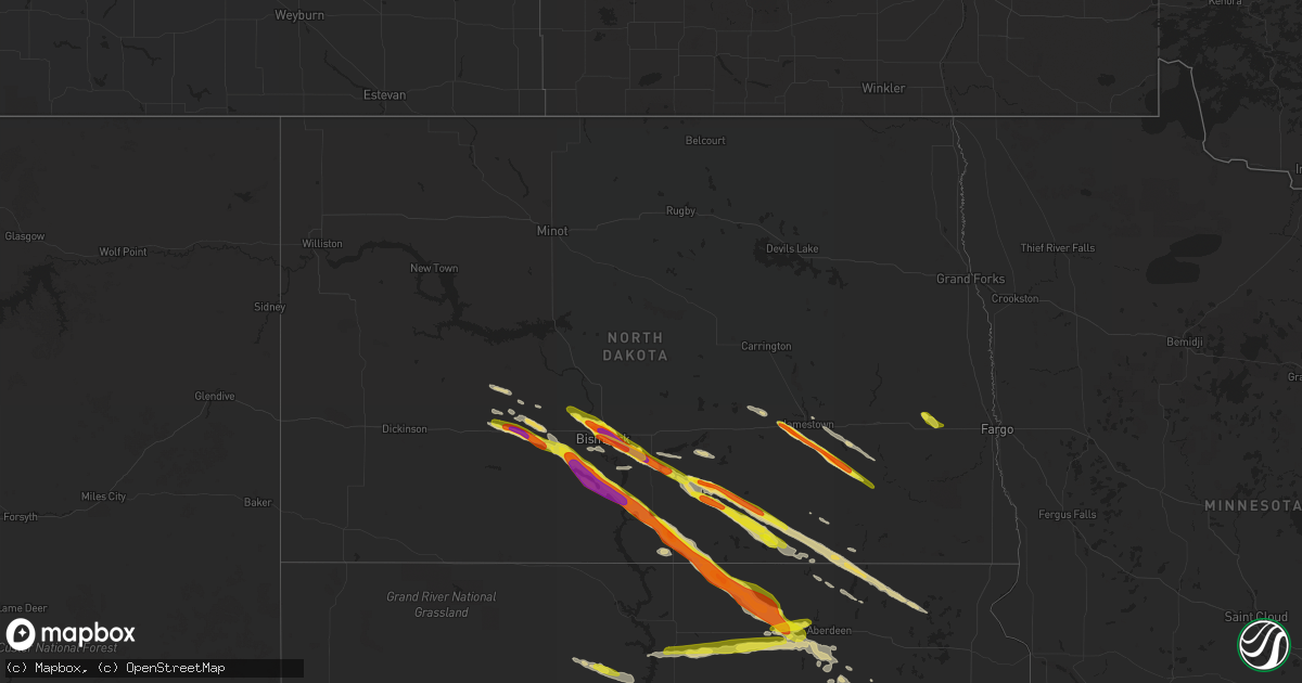
Hail Map in North Dakota on July 21, 2022
Get this storm
July 21 map
$229
one time, instant access
Download today. No call, no setup
Keep the $229
Bought the map and want the full workflow? Apply the entire $229 to a subscription within 7 days. None of it is wasted.
Every map, not just this one
This buys you this map. Subscription and you get every map we run, in the markets you choose from a few cities to whole states to nationwide. Plus real-time alerts the moment a storm fires.
Contact data
Name, contact info, occupancy, even credit band for addresses in the footprint. You go from where it hit to who to call.
Become the source they trust
Unlimited branding weather history reports on demand. You already have the documented answer ready for the property owner, and you are the one who showed up with it.
Property data and RoofTrace estimates
Pull up any address you have got, its value and the exact code rules for that jurisdiction, straight from One Click Code. Then RoofTrace estimates the squares, pitch, and roof value, priced the way you price.
Storm reports in North Dakota
North Dakota
| Date | Description |
|---|---|
| 07/21/20226:55 PM CDT | A local report indicates 1.75 inch wind near STRASBURG |
| 07/21/20226:30 PM CDT | A local report indicates 1.00 inch wind near 13 SW MERRICOURT |
| 07/21/20226:02 PM CDT | A local report indicates 1.25 inch wind near 5 N WISHEK |
| 07/21/20225:59 PM CDT | A local report indicates 1.00 inch wind near 4 N WISHEK |
| 07/21/20225:51 PM CDT | Measured as a quarter hour and half after hail had fallen. Hail caused considerable crop damage. |
| 07/21/20225:50 PM CDT | Hail was found at least 30 minutes after it fell and had melted some... But was still quarter size. |
| 07/21/20225:42 PM CDT | Social media reported ping pong sized hail in picture. |
| 07/21/20225:05 PM CDT | Quarter size hail to ping pong size hail. Hail caused wide spread crop damage. |
| 07/21/20224:58 PM CDT | A local report indicates 1.00 inch wind near 9 W NEW SALEM |
| 07/21/20224:50 PM CDT | Social media report with picture. Estimated at 2 inches in diameter. |
| 07/21/20224:40 PM CDT | A local report indicates 1.25 inch wind near 1 NNE LINCOLN |
| 07/21/20224:37 PM CDT | Downtown bismarck. This was the second storm which moved through the city. |
| 07/21/20224:35 PM CDT | A local report indicates 1.00 inch wind near 2 SE BISMARCK |
| 07/21/20224:30 PM CDT | A local report indicates 2.50 inch wind near 3 N LINCOLN |
| 07/21/20224:13 PM CDT | A local report indicates 1.75 inch wind near 3 N BISMARCK |
| 07/21/20224:13 PM CDT | A local report indicates 2.50 inch wind near 2 NE BISMARCK |
| 07/21/20224:07 PM CDT | A local report indicates 1.25 inch wind near 3 N BISMARCK |
| 07/21/20224:07 PM CDT | A local report indicates 1.00 inch wind near 5 NNW BISMARCK |
| 07/21/20224:06 PM CDT | A local report indicates 1.00 inch wind near 4 N BISMARCK |
| 07/21/20224:05 PM CDT | A local report indicates 1.50 inch wind near 3 NNE MANDAN |
| 07/21/20225:15 AM CDT | At 1015 PM CDT, a severe thunderstorm was located 9 miles southeast of Ellendale, moving southeast at 55 mph. HAZARD...Quarter size hail. SOURCE...Radar indicated. IMPACT...Damage to vehicles is expected. This severe thunderstorm will be near... Hecla and Sand Lake Wildlife Refuge around 1025 PM CDT.Other locations in the path of this severe thunderstorm includeClaremont. |
| 07/21/20224:52 AM CDT | At 952 PM CDT, a severe thunderstorm was located 11 miles north of Forbes, or 11 miles northwest of Ellendale, moving southeast at 50 mph. HAZARD...Quarter size hail. SOURCE...Radar indicated. IMPACT...Damage to vehicles is expected. Locations impacted include... Oakes, Ellendale, Fullerton, Ludden, Monango, Guelph, Glover and Merricourt. |
| 07/21/20224:15 AM CDT | At 915 PM CDT, a severe thunderstorm was located near Lehr, or 21 miles north of Ashley, moving southeast at 45 mph. HAZARD...Half dollar size hail. SOURCE...Radar indicated. IMPACT...Damage to vehicles is expected. Locations impacted include... Kulm. |
| 07/21/20223:48 AM CDT | At 848 PM CDT, a severe thunderstorm was located over Napoleon, moving east at 30 mph. HAZARD...60 mph wind gusts and half dollar size hail. SOURCE...Radar indicated. IMPACT...Hail damage to vehicles is expected. Expect wind damage to roofs, siding, and trees. This severe thunderstorm will remain over mainly rural areas of central Logan County, including the following locations... Burnstad and Beaver Lake State Park. |
| 07/21/20223:28 AM CDT | At 827 PM CDT, a severe thunderstorm was located near Buffalo, or 23 miles east of Valley City, moving southeast at 45 mph. HAZARD...60 mph wind gusts and quarter size hail. SOURCE...Radar indicated. IMPACT...Hail damage to vehicles is expected. Expect wind damage to roofs, siding, and trees. This severe thunderstorm will be near... Absaraka around 835 PM CDT. Wheatland around 840 PM CDT. Amenia around 845 PM CDT.Other locations in the path of this severe thunderstorm includeCasselton and Durbin.This includes Interstate 94 in North Dakota between mile markers 317and 342. |
| 07/21/20223:00 AM CDT | At 800 PM CDT, a severe thunderstorm was located 6 miles northwest of Marion, or 21 miles southeast of Jamestown, moving southeast at 45 mph. HAZARD...Quarter size hail. SOURCE...Radar indicated. IMPACT...Damage to vehicles is expected. Locations impacted include... Marion. |
| 07/21/20222:58 AM CDT | At 757 PM CDT, a severe thunderstorm was located 7 miles east of Montpelier, or 24 miles southwest of Valley City, moving southeast at 45 mph. HAZARD...60 mph wind gusts and quarter size hail. SOURCE...Radar indicated. IMPACT...Hail damage to vehicles is expected. Expect wind damage to roofs, siding, and trees. This severe thunderstorm will be near... Litchville around 815 PM CDT.Other locations in the path of this severe thunderstorm includeHastings. |
| 07/21/20222:31 AM CDT | At 731 PM CDT, a severe thunderstorm was located 7 miles west of Jamestown, moving southeast at 40 mph. HAZARD...60 mph wind gusts and quarter size hail. SOURCE...Radar indicated. IMPACT...Hail damage to vehicles is expected. Expect wind damage to roofs, siding, and trees. This severe thunderstorm will be near... Jamestown around 740 PM CDT.Other locations in the path of this severe thunderstorm includeYpsilanti and Montpelier. |
| 07/21/20222:17 AM CDT | At 716 PM CDT, a severe thunderstorm was located near Zeeland, or 20 miles northwest of Eureka, moving southeast at 35 mph. HAZARD...Golf ball size hail and 60 mph wind gusts. SOURCE...Trained weather spotters. IMPACT...People and animals outdoors will be injured. Expect hail damage to roofs, siding, windows, and vehicles. Expect wind damage to roofs, siding, and trees. This severe thunderstorm will be near... Artas around 730 PM CDT. Greenway around 735 PM CDT.Other locations in the path of this severe thunderstorm includeEureka, Hillsview and New Town Corner. |
| 07/21/20221:54 AM CDT | At 654 PM CDT, a severe thunderstorm was located near Forbes, or 16 miles west of Ellendale, moving southeast at 35 mph. HAZARD...60 mph wind gusts and quarter size hail. SOURCE...Radar indicated. IMPACT...Hail damage to vehicles is expected. Expect wind damage to roofs, siding, and trees. This severe thunderstorm will be near... Forbes around 705 PM CDT.Other locations in the path of this severe thunderstorm include ElmLake, Frederick and Barnard. |
| 07/21/202212:37 AM CDT | At 536 PM CDT, a severe thunderstorm was located 7 miles southeast of Fish Creek Dam, or 14 miles southwest of Mandan, moving southeast at 40 mph. HAZARD...Golf ball size hail and 60 mph wind gusts. SOURCE...Radar indicated. IMPACT...People and animals outdoors will be injured. Expect hail damage to roofs, siding, windows, and vehicles. Expect wind damage to roofs, siding, and trees. This severe thunderstorm will be near... St. Anthony around 550 PM CDT.Other locations in the path of this severe thunderstorm includeCannon Ball. |
| 07/20/202211:44 PM CDT | At 443 PM CDT, severe thunderstorms were located along a line extending from 6 miles west of Hannover to 6 miles east of Glen Ullin, moving southeast at 40 mph. HAZARD...Golf ball size hail and 60 mph wind gusts. SOURCE...Radar indicated. IMPACT...People and animals outdoors will be injured. Expect hail damage to roofs, siding, windows, and vehicles. Expect wind damage to roofs, siding, and trees. Severe thunderstorms will be near... Hannover around 450 PM CDT. New Salem, Center and Almont around 500 PM CDT.Other locations in the path of these severe thunderstorms includeFish Creek Dam, Lake Harmon and Mandan. |
| 07/20/202211:33 PM CDT | At 432 PM CDT, a severe thunderstorm was located 6 miles south of Menoken, or 13 miles east of Bismarck, moving southeast at 30 mph. HAZARD...60 mph wind gusts and half dollar size hail. SOURCE...Radar indicated. IMPACT...Hail damage to vehicles is expected. Expect wind damage to roofs, siding, and trees. Locations impacted include... Hazelton, Menoken, Sterling, Braddock, Mckenzie, Moffit and Kintyre. |
| 07/20/202210:51 PM CDT | At 351 PM CDT, a severe thunderstorm was located near Lake Harmon, or 10 miles northwest of Mandan, moving southeast at 20 mph. HAZARD...60 mph wind gusts and quarter size hail. SOURCE...Radar indicated. IMPACT...Hail damage to vehicles is expected. Expect wind damage to roofs, siding, and trees. This severe thunderstorm will be near... Lake Harmon around 400 PM CDT. Mandan around 410 PM CDT.Other locations in the path of this severe thunderstorm includeBismarck, Lincoln, Menoken and Mcdowell Dam Recreation Area. |
| 07/20/202210:07 PM CDT | Crop damage from hail. |
| 07/20/20229:31 PM CDT | Extensive crop damage from hail. |
| 07/20/20228:51 PM CDT | Public reported golf ball sized hail. Radar estimated time. |
| 07/20/20228:49 PM CDT | Hail lasted for about 3 minutes. |
| 07/20/20228:36 PM CDT | Pea to quarter sized hail. |
| 07/20/20228:36 PM CDT | Pea to quarter sized hail. |
| 07/20/20228:14 PM CDT | Hail is coating the ground mostly pea size with some quarters and ping pong size hail. |
| 07/20/20228:05 PM CDT | A swath of large hail swept across southwestern greenland township... Extending from southeast stutsman county into northcentral dickey county. Reports state that hail |
| 07/20/20227:55 PM CDT | Hail ranged in diameter from half dollar to golf ball size... With most of it being ping pong ball size. The hail had a white core about 3/4 inch in diameter with the r |
| 07/20/20227:35 PM CDT | Corrects previous hail report from eldridge. Social media report. Estimated at golf ball size. |
| 07/20/20227:25 PM CDT | Pea to nickel size hail along with very heavy rain accompanied the severe thunderstorm wind gust. |
| 07/20/20227:25 PM CDT | Pea to nickel size hail along with very heavy rain acc |
All States Impacted by Hail Map on July 21, 2022
Cities Impacted by Hail Map on July 21, 2022
- Vienna, SD
- Bryant, SD
- Jamestown, ND
- Ipswich, SD
- Roscoe, SD
- East Charleston, VT
- Eden Mills, VT
- Irasburg, VT
- Morgan, VT
- Orleans, VT
- Averill, VT
- Wolcott, VT
- West Stewartstown, NH
- Norton, VT
- Island Pond, VT
- Newport, VT
- Hyde Park, VT
- West Charleston, VT
- Pittsburg, NH
- Albany, VT
- Beecher Falls, VT
- Craftsbury, VT
- Barton, VT
- Craftsbury Common, VT
- Colebrook, NH
- Canaan, VT
- Wheatland, ND
- Buffalo, ND
- Salem, NY
- Dupree, SD
- Eagle Butte, SD
- Edgeley, ND
- Ashley, ND
- Forbes, ND
- Roslyn, SD
- Mandan, ND
- Langford, SD
- Lehr, ND
- Kintyre, ND
- Moffit, ND
- Sterling, ND
- Bismarck, ND
- Ellendale, ND
- Napoleon, ND
- Braddock, ND
- Hecla, SD
- Claremont, SD
- Britton, SD
- Eden, SD
- Wishek, ND
- Kulm, ND
- Amherst, SD
- Frederick, SD
- Oakes, ND
- Menoken, ND
- Fredonia, ND
- Eustis, ME
- Richford, VT
- Montgomery Center, VT
- Timber Lake, SD
- New Salem, ND
- Tahlequah, OK
- Browns Summit, NC
- Pardeeville, WI
- Rio, WI
- Poynette, WI
- Columbus, WI
- Turton, SD
- Doland, SD
- Mellette, SD
- Raymond, SD
- Ashton, SD
- Conde, SD
- Onaka, SD
- Warner, SD
- Selby, SD
- Saint Anthony, ND
- Java, SD
- Hazelton, ND
- Northville, SD
- Bowdle, SD
- Flasher, ND
- Hague, ND
- Eureka, SD
- Leola, SD
- Tolstoy, SD
- Hosmer, SD
- Mansfield, SD
- Westport, SD
- Zeeland, ND
- Aberdeen, SD
- Cannon Ball, ND
- Strasburg, ND
- Linton, ND
- Hoven, SD
- Solen, ND
- Almont, ND
- Glen Ullin, ND
- Big Falls, MN
- Greenville Junction, ME
- Greenville, ME
- Shirley Mills, ME
- Monson, ME
- Abbot, ME
- Marion, ND
- Litchville, ND
- Spiritwood, ND
- Kathryn, ND
- Sanborn, ND
- Hebron, ND
- Beulah, ND
- South Hero, VT
- Peru, NY
- Keeseville, NY
- Fort Edward, NY
- Hudson Falls, NY
- Argyle, NY
- Fort Ann, NY
- Stuart, NE
- Putney, VT
- Westminster, VT
- Phil Campbell, AL
- Haleyville, AL
- Bear Creek, AL
- Claremont, NH
- Charlestown, NH
- Dewitt, VA
- Wilsons, VA
- McKenney, VA
- Steele, ND
- Tappen, ND
- Dawson, ND
- Ypsilanti, ND
- Montpelier, ND
- Newport Center, VT
- North Platte, NE
- Maxwell, NE
- West Newfield, ME
- Parsonsfield, ME
- Limerick, ME
- Standish, ME
- East Wakefield, NH
- Steep Falls, ME
- Limington, ME
- Sanbornville, NH
- Saint Johnsbury, VT
- Monroe, NH
- Littleton, NH
- North Stratford, NH
- Lawrenceville, VA
- Rosston, OK
- Gansevoort, NY
- Schuylerville, NY
- Belvidere Center, VT
- Rockford, MI
- Conklin, MI
- Marne, MI
- Coopersville, MI
- Belmont, MI
- Grand Rapids, MI
- Comstock Park, MI
- Hartford, SD
- Humboldt, SD
- Council Bluffs, IA
- Pipestone, MN
- Newfane, VT
- Perryton, TX
- Hudson, SD
- Champion, NE
- Imperial, NE
- Callaway, NE
- Gothenburg, NE
- Chesterfield, VA
- Henrico, VA
- Pawnee, OK
- Roxbury, CT
- Bridgewater, CT
- Woodbury, CT
- Washington, CT
- Pawling, NY
- Holmes, NY
- Patterson, NY
- New Milford, CT
- Carmel, NY
- Sherman, CT
- Genoa, NE
- Columbus, NE
- Monroe, NE
- Sandston, VA
- Hodgen, OK
- Perry, OK
- Alstead, NH
- Keene, NH
- Westmoreland, NH
- Walpole, NH
- Bryant, AL
- Trenton, GA
- Rose, OK
- Lewisburg, TN
- Jasper, TN
- South Pittsburg, TN
- Lake Village, AR
- Anniston, AL
- West Point, MS
- Cedarbluff, MS
- Anderson, AL
- Lexington, AL
- Hope Hull, AL
- Montgomery, AL
- Centreville, AL
- Brent, AL
- Stigler, OK
- Forest, MS
- Lena, MS
- Mayersville, MS
- McCool, MS
- Louisville, MS
- Macon, GA
- Riverside, AL
- Pell City, AL
- Kosciusko, MS
- Eatonton, GA
- Buffalo, OK
- Forsyth, GA
- Barnesville, GA
- Marion, AL
- Mena, AR
- Collins, MS
- Buhl, AL
- Eutaw, AL
- Aliceville, AL
- Gordo, AL
- Ralph, AL
- Knoxville, AL
- Boligee, AL
- Attalla, AL
- Gadsden, AL
- Moundville, AL
- Akron, AL
- Phenix City, AL
- Hamilton, AL
- Livingston, LA
- Nashville, AR
- McCaskill, AR
- Murfreesboro, AR
- De Kalb, MS
- Warren, NH
- Franklin, GA
- Hogansville, GA
- Tyler, AL
- Lowndesboro, AL
- Lake, MS
- Sebago, ME
- East Baldwin, ME
- Roland, OK
- Muldrow, OK
- Thomaston, GA
- Spiro, OK
- Seale, AL
- Vian, OK
- Bunch, OK
- Cookson, OK
- Sallisaw, OK
- Marion Junction, AL
- Fort Mitchell, AL
- Bowling Green, FL
- Pittsview, AL
- Labelle, FL
- Oakman, AL
- Vaiden, MS
- Brattleboro, VT
- West Chesterfield, NH
- South Ryegate, VT
- Newbury, VT
- Adger, AL
- Broken Arrow, OK
- Catherine, AL
- Pine Hill, AL
- Miami, AZ
- Globe, AZ
- Wingdale, NY
- Gaylordsville, CT
- Brookings, SD
- Houghton, SD
- West Forks, ME
- Brookline, NH
- Reidsville, NC
- Sparkman, AR
- Stilwell, OK
- Tuscumbia, AL
- Cherokee, AL
- Florence, AL
- Umpire, AR
- Wickes, AR
- Gurdon, AR
- Arkadelphia, AR
- Prescott, AR
- Sylacauga, AL
- Birmingham, AL
- Shelby, AL
- Sterrett, AL
- Columbiana, AL
- Chelsea, AL
- Wilsonville, AL
- Hollandale, MS
- Eudora, AR
- Loving, NM
- Reform, AL
- Cottondale, AL
- Tuscaloosa, AL
- Lafayette, AL
- Waverly, AL
- Dermott, AR
- Berry, AL
- Northport, AL
- Glenwood, AR
- Caddo Gap, AR
- Pleasant Grove, AL
- Dolomite, AL
- Fairfield, AL
- Bessemer, AL
- East Corinth, VT
- Topsham, VT
- Wells River, VT
- Center Ossipee, NH
- Effingham, NH
- Grantham, NH
- Windsor, VT
- Enfield, NH
- Raymond, ME
- West Baldwin, ME
- Center Tuftonboro, NH
- Plainfield, NH
- Cornish, NH
- Springfield, VT
- Hill, NH
- Ossipee, NH
- Meredith, NH
- Canaan, NH
- Laconia, NH
- Perkinsville, VT
- Ascutney, VT
- Moultonborough, NH
- Danbury, NH
- Holderness, NH
- Center Harbor, NH
- Windham, ME
- Bristol, NH
- New London, NH
- New Hampton, NH
- Newport, NH
- Wilmot, NH
- Gray, ME
- Sanbornton, NH
- Sunapee, NH
- Cornish, ME
- Grafton, NH
- Springfield, NH
- Hiram, ME
- Plymouth, NH
- Belgrade, NE
- Cedar Rapids, NE
- Eau Claire, MI
- Elkhart, IN
- Bristol, IN
- Berrien Center, MI
- Granger, IN
- Niles, MI
- Dowagiac, MI
- Sodus, MI
- Watervliet, MI
- Osceola, IN
- Saint Joseph, MI
- Stevensville, MI
- Cassopolis, MI
- Middlebury, IN
- Edwardsburg, MI
- Goshen, IN
- Hartford, MI
- Coloma, MI
- Benton Harbor, MI
- Union, MI
- Proctorsville, VT
- Cavendish, VT
- Chester, VT
- Sutherland, VA
- Church Road, VA
- Petersburg, VA
- Bayside, NY
- Fairview, NJ
- Passaic, NJ
- Queens Village, NY
- Glen Ridge, NJ
- Palisades Park, NJ
- Hicksville, NY
- Greenvale, NY
- Wood Ridge, NJ
- Port Washington, NY
- Commack, NY
- Bloomfield, NJ
- Bay Shore, NY
- Fresh Meadows, NY
- Montclair, NJ
- Nutley, NJ
- Islip Terrace, NY
- Farmingville, NY
- Bohemia, NY
- New York, NY
- Jamaica, NY
- Little Neck, NY
- Roslyn Heights, NY
- Medford, NY
- East Islip, NY
- Teterboro, NJ
- Oakland Gardens, NY
- New Hyde Park, NY
- Williston Park, NY
- Mineola, NY
- Rutherford, NJ
- Huntington, NY
- Islip, NY
- Ronkonkoma, NY
- Albertson, NY
- Farmingdale, NY
- Holtsville, NY
- Glen Oaks, NY
- Roslyn, NY
- Woodbury, NY
- Holbrook, NY
- Old Bethpage, NY
- Wallington, NJ
- Deer Park, NY
- Huntington Station, NY
- North Bergen, NJ
- Floral Park, NY
- Patchogue, NY
- Jericho, NY
- Edgewater, NJ
- Moonachie, NJ
- Hollis, NY
- Wyandanch, NY
- Plainview, NY
- Bronx, NY
- East Rutherford, NJ
- Bayport, NY
- Bethpage, NY
- Hauppauge, NY
- Glen Head, NY
- Hasbrouck Heights, NJ
- Central Islip, NY
- Cliffside Park, NJ
- Ridgefield Park, NJ
- Sayville, NY
- Melville, NY
- Islandia, NY
- Bellerose, NY
- Flushing, NY
- Syosset, NY
- Ridgefield, NJ
- Carlstadt, NJ
- Little Ferry, NJ
- Manhasset, NY
- Great Neck, NY
- Brentwood, NY
- Lyndhurst, NJ
- Fort Lee, NJ
- Westbury, NY
- Old Westbury, NY
- Clifton, NJ
- Fremont, NE
- Valley, NE
- Yutan, NE
- Howe, OK
- Poteau, OK
- Locust Grove, OK
- Bethlehem, CT
- Watertown, CT
- Porum, OK
- Marlborough, NH
- Chesterfield, NH
- Nelson, NH
- Hinsdale, NH
- Spofford, NH
- Dublin, NH
- Harrisville, NH
- Ashuelot, NH
- Winchester, NH
- Troy, NH
- Vernon, VT
- Sullivan, NH
- Fitzwilliam, NH
- Swanzey, NH
- Rainbow City, AL
- Temple, GA
- Muskogee, OK
- Braggs, OK
- Morrison, OK
- Aberdeen, MS
- Gans, OK
- Keota, OK
- Killen, AL
- Rogersville, AL
- Courtland, AL
- Town Creek, AL
- Mount Hope, AL
- Leighton, AL
- Russellville, AL
- Sturgis, MS
- Ackerman, MS
- Parrish, AL
- Townley, AL
- Faunsdale, AL
- Oxford, AL
- Munford, AL
- Cove, AR
- Hatfield, AR
- Leeds, AL
- Taylorsville, MS
- Mize, MS
- Gallant, AL
- Oneonta, AL
- Altoona, AL
- Salem, AL
- Opelika, AL
- Fitzpatrick, AL
- Hardaway, AL
- Union Springs, AL
- Moody, AL
- Vincent, AL
- Talladega, AL
- Cropwell, AL
- Harpersville, AL
- Childersburg, AL
- Alpine, AL
- Odenville, AL
- Enterprise, MS
- Perrin, TX
- Prattville, AL
- Union, MS
- Philadelphia, MS
- Fullerton, ND
- Uniontown, AL
- Beresford, SD
- Checotah, OK
- Sutton, VT
- Lennox, SD
- Douglas, AZ
- Orford, NH
- Piermont, NH
- Wentworth, NH
- Lebanon, SD
- Parker, SD
- Tea, SD
- Chancellor, SD
- Valley, AL
- Cusseta, AL
- Lauderdale, MS
- Toomsuba, MS
- Westfield, VT
- Arlington, SD
- Lake Preston, SD
- Bruce, SD
- Erwin, SD
- Volga, SD
- Willow Lake, SD
- De Smet, SD
- Mendon, MI
- Townsend, MA
- Greenville, NH
- Ashby, MA
- West Townsend, MA
- Ashburnham, MA
- David City, NE
- Malmo, NE
- Linwood, NE
- Morse Bluff, NE
- Schuyler, NE
- Colon, NE
- Prague, NE
- Cedar Bluffs, NE
- Rogers, NE
- Bellwood, NE
- Hyannis, NE
- Cambridge, NY
- Buskirk, NY
- Eagle Bridge, NY
- Grayslake, IL
- Libertyville, IL
- Lake Forest, IL
- Highland Park, IL
- Lake Bluff, IL
- Mundelein, IL
- Castana, IA
- Onawa, IA
- Arlington, VT
- Saratoga Springs, NY
- Greenwich, NY
- Stillwater, NY
- Shushan, NY
- Tulsa, OK
- Bronson, IA
- Mullen, NE
- Seneca, NE
- Locust Fork, AL
- Trafford, AL
- Remlap, AL
- Norwood, NJ
- Nyack, NY
- Elmsford, NY
- Piermont, NY
- Northvale, NJ
- Tarrytown, NY
- Pleasantville, NY
- Irvington, NY
- Orangeburg, NY
- Valhalla, NY
- Palisades, NY
- Thornwood, NY
- Sparkill, NY
- Tappan, NY
- Alpine, NJ
- Hawthorne, NY
- Enders, NE
- Columbia, NC
- Dierks, AR
- Orange City, IA
- Maurice, IA
- Alton, IA
- Le Mars, IA
- Sioux Center, IA
- Ireton, IA
- McCalla, AL
- Montevallo, AL
- West Blocton, AL
- Dora, AL
- Fultondale, AL
- Mount Olive, AL
- Brierfield, AL
- Docena, AL
- Gardendale, AL
- Quinton, AL
- Helena, AL
- Mulga, AL
- Cordova, AL
- Alabaster, AL
- Adamsville, AL
- Brookwood, AL
- Hillsboro, AL
- Ozan, AR
- Hurtsboro, AL
- Sparta, GA
- Kennedy, AL
- Lincoln, AL
- Amity, AR
- Delta, AL
- Wedowee, AL
- Lineville, AL
- Claude, TX
- Warrior, AL
- Kimberly, AL
- Morris, AL
- Maben, MS
- Pheba, MS
- Orrville, AL
- Columbia, SD
- Arlington, AL
- Maplesville, AL
- Clanton, AL
- Billingsley, AL
- Plantersville, AL
- Concord, VT
- Granby, VT
- Lunenburg, VT
- Guildhall, VT
- North Concord, VT
- Cameron, OK
- Hackett, AR
- Redfield, SD
- Elkhorn, NE
- Exeter, NH
- Kingston, NH
- Sandown, NH
- Fremont, NH
- Danville, NH
- Anselmo, NE
- Jarratt, VA
- Emporia, VA
- Coldwater, MI
- Tekonsha, MI
- Quincy, MI
- Bradford, VT
- Valley Falls, NY
- Schaghticoke, NY
- Johnsonville, NY
- Decatur, MI
- Blevins, AR
- Kent, CT
- South Kent, CT
- West Point, GA
- Tremont, MS
- Detroit, AL
- Smithville, MS
- Beaverton, AL
- Sulligent, AL
- Gattman, MS
- Caledonia, MS
- Greenwood Springs, MS
- Amory, MS
- Woodland, AL
- Graham, AL
- Ranburne, AL
- Rosston, AR
- Gallion, AL
- Forkland, AL
- Livingston, AL
- Cuba, AL
- York, AL
- Demopolis, AL
- Greensboro, AL
- West Burke, VT
- West Rupert, VT
- Safford, AL
- Chidester, AR
- Ashland, NH
- Wolbach, NE
- Ansley, NE
- Broken Bow, NE
- Oconto, NE
- Mason City, NE
- Merna, NE
- Arriba, CO
- Catoosa, OK
- Atkinson, NE
- Winchendon, MA
- Athol, MA
- Baldwinville, MA
- Correctionville, IA
- Pierson, IA
- Greenwood, MS
- Sidon, MS
- Idalia, CO
- Colonial Heights, VA
- Bearden, AR
- Vicksburg, MI
- Schoolcraft, MI
- Portage, MI
- Rock Island, TN
- Muscle Shoals, AL
- Steele, AL
- Springville, AL
- Tchula, MS
- Lexington, MS
- Starkville, MS
- Macon, MS
- South Deerfield, MA
- Orange, MA
- Lake Pleasant, MA
- Deerfield, MA
- Royalston, MA
- Erving, MA
- Warwick, MA
- Wendell Depot, MA
- Pepperell, MA
- Gardner, MA
- Hollis, NH
- Petersham, MA
- Millers Falls, MA
- Montague, MA
- New Salem, MA
- Wendell, MA
- Minter, AL
- Brady, NE
- Dinwiddie, VA
- Springer, NM
- Hooksett, NH
- Manchester, NH
- Goffstown, NH
- Auburn, NH
- New Boston, NH
- Mcminnville, TN
- Hereford, TX
- Wildorado, TX
- Delight, AR
- Nettleton, MS
- Petersburg, TX
- Idalou, TX
- Abernathy, TX
- Davis, SD
- Mineral Springs, AR
- Lockesburg, AR
- Jacksboro, TX
- Claypool, AZ
- Newbern, AL
- Walker, LA
- Haverhill, NH
- Rangeley, ME
- Cleveland, AL
- Hebron, NH
- Midway, AL
- Clayton, AL
- Lowell, VT
- Center Sandwich, NH
- Long Valley, SD
- Wanblee, SD
- Saint Francis, SD
- Parmelee, SD
- Norris, SD
- Meansville, GA
- The Rock, GA
- Worthing, SD
- Proctor, OK
- Trappe, MD
- East New Market, MD
- Cambridge, MD
- Arnold, NE
- Whitman, NE
- Merriman, NE
- Mead, NE
- Cleveland, ND
- Medina, ND
- Ashville, AL
- Frankfort, SD
- Sardis, AL
- Eastaboga, AL
- Eupora, MS
- Ocate, NM
- Walnut Grove, MS
- Hatchechubbee, AL
- Inverness, MS
- Isola, MS
- Letohatchee, AL
- Ethel, MS
- San Simon, AZ
- Hampton, AR
- Warren, AR
- Thornton, AR
- Banks, AR
- Raleigh, MS
- Mansfield, AR
- Booneville, AR
- Gillham, AR
- Berlin, MD
- Newark, MD
- Hayes, SD
- South Glens Falls, NY
- Raton, NM
- Snow Hill, MD
- Mishawaka, IN
- Cozad, NE
- Brodnax, VA
- Athens, AL
- Lester, AL
- Elkmont, AL
- Waldron, AR
- Fort Smith, AR
- Boles, AR
- Hartford, AR
- Pocola, OK
- Newhope, AR
- Summerville, GA
- Leesburg, AL
- Eden, VT
- Lebanon, NH
- Young, AZ
- Lexington, NE
- Eddyville, NE
- Payson, AZ
- Vandervoort, AR
- Collinsville, MS
- Lanett, AL
- Lagrange, GA
- Mathews, AL
- Cecil, AL
- Heflin, AL
- Carthage, MS
- Springfield, LA
- Stapleton, NE
- Hurley, SD
- Centerville, SD
- Rodeo, NM
- Thedford, NE
- Fullerton, NE
- King William, VA
- West Point, VA
- New Kent, VA
- Katonah, NY
- Mount Kisco, NY
- Bedford Hills, NY
- Bedford, NY
- Gore, OK
- Waterloo, NE
- Smithville, OK
- Bokoshe, OK
- Creswell, NC
- Carbon Hill, AL
- Fayette, AL
- Villa Rica, GA
- Carrollton, GA
- Parks, AR
- Bentonia, MS
- Fordyce, AR
- Harrell, AR
- Princess Anne, MD
- Wetumpka, AL
- Jasper, AL
- Woodland, MS
- Mantee, MS
- Lawley, AL
- Heavener, OK
- Coila, MS
- Louin, MS
- Carrollton, AL
- South Bend, TX
- Graham, TX
- Breckenridge, TX
- Trussville, AL
- De Queen, AR
- Van Buren, AR
- Stanton, AL
- Pinson, AL
- Millport, AL
- Lawrence, MS
- Newton, MS
- Rose Hill, MS
- Meridian, MS
- Chunky, MS
- Hickory, MS
- Williamsville, VT
- Guadalupita, NM
- Gainesville, AL
- Epes, AL
- Fosters, AL
- Roanoke, AL
- Shuqualak, MS
- Scooba, MS
- Yazoo City, MS
- Silver City, MS
- Benton, MS
- Fort Benning, GA
- Shady Point, OK
- Bondville, VT
- Manchester, VT
- Manchester Center, VT
- Ballston Spa, NY
- Chattanooga, TN
- Little Plymouth, VA
- Vina, AL
- Red Bay, AL
- Chester, VA
- Northfield, MA
- Belzoni, MS
- Stephens, AR
- Camden, AR
- Columbus, MS
- Coosada, AL
- Deatsville, AL
- Elmore, AL
- Five Points, AL
- Sharon, VT
- West Hartford, VT
- Norwich, VT
- North Pomfret, VT
- Gettysburg, SD
- White Pigeon, MI
- Jersey City, NJ
- Ridgewood, NY
- Brooklyn, NY
- Middle Village, NY
- Maspeth, NY
- Hamilton, MS
- Ramer, AL
- Winona, MS
- Ona, FL
- Bartow, FL
- Quitman, MS
- Elfrida, AZ
- Stratford, SD
- Wauneta, NE
- Briarcliff Manor, NY
- North Haverhill, NH
- Valentine, NE
- Center, ND
- Long Lake, SD
- Verona, ND
- Akaska, SD
- Porter, ME
- Sioux Falls, SD
- Chappaqua, NY
- Nesconset, NY
- Graysville, AL
- Pelham, AL
- Calera, AL
- Jemison, AL
- Goodwater, AL
- Kellyton, AL
- Weogufka, AL
- Rockford, AL
- Sparta, MI
- Gorham, ME
- Levittown, NY
- North Babylon, NY
- Great River, NY
- West Islip, NY
- Seaford, NY
- West Babylon, NY
- Massapequa, NY
- West Sayville, NY
- Brightwaters, NY
- Oakdale, NY
- Wantagh, NY
- North Woodstock, NH
- Weare, NH
- Hampstead, NH
- Atkinson, NH
- Bonnerdale, AR
- Halsey, NE


