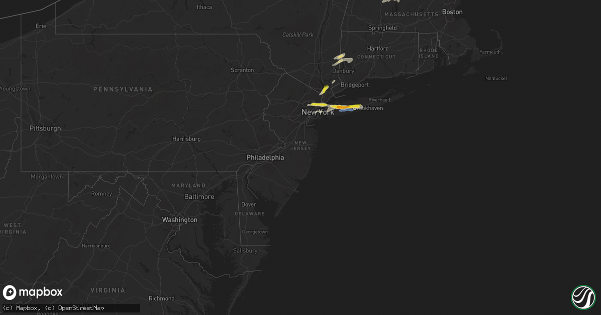
Hail Map in New Jersey on July 21, 2022
Get this storm
July 21 map
$229
one time, instant access
Download today. No call, no setup
Keep the $229
Bought the map and want the full workflow? Apply the entire $229 to a subscription within 7 days. None of it is wasted.
Every map, not just this one
This buys you this map. Subscription and you get every map we run, in the markets you choose from a few cities to whole states to nationwide. Plus real-time alerts the moment a storm fires.
Contact data
Name, contact info, occupancy, even credit band for addresses in the footprint. You go from where it hit to who to call.
Become the source they trust
Unlimited branding weather history reports on demand. You already have the documented answer ready for the property owner, and you are the one who showed up with it.
Property data and RoofTrace estimates
Pull up any address you have got, its value and the exact code rules for that jurisdiction, straight from One Click Code. Then RoofTrace estimates the squares, pitch, and roof value, priced the way you price.
Storm reports in New Jersey
New Jersey
| Date | Description |
|---|---|
| 07/21/20222:30 PM CDT | Evesham twp. Pd reports wires down on north elmwood road near route 70. Time estimated via radar. |
| 07/21/20222:28 PM CDT | Trees down on wires/equipment. Time estimated via radar. |
| 07/21/202211:50 AM CDT | Trees and wires down on rairoad ave. Time estimated from radar. |
| 07/21/202211:40 AM CDT | Tree on a house and car on east passaic and wachung ave. Time estimated from radar. |
| 07/20/202210:12 PM CDT | At 312 PM EDT, a severe thunderstorm was located over Ashland, or near Gloucester City, moving east at 20 mph. HAZARD...60 mph wind gusts. SOURCE...Radar indicated. IMPACT...Damage to roofs, siding, trees, and power lines is possible. Locations impacted include... Cherry Hill, Evesham, Mount Laurel, Voorhees, Medford, Lindenwold, Lumberton, Mount Holly, Tabernacle, Magnolia, Ramblewood, Barclay-Kingston, Echelon, Marlton, Leisuretowne, Ashland, Springdale, Erlton-Ellisburg, Greentree and Jacksonville.This includes the following highways... New Jersey Turnpike near exit 4. Interstate 295 in New Jersey between mile markers 30 and 44. |
| 07/20/20228:14 PM CDT | At 114 PM EDT, a severe thunderstorm was located over Nyack, moving northeast at 30 mph. HAZARD...60 mph wind gusts and quarter size hail. SOURCE...Radar indicated. IMPACT...Minor hail damage to vehicles is possible. Expect wind damage to trees and power lines. This severe thunderstorm will be near... Ossining and Hawthorne around 120 PM EDT. Mount Kisco and Bedford around 130 PM EDT. Yorktown Heights around 135 PM EDT. Mahopac around 140 PM EDT. |
All States Impacted by Hail Map on July 21, 2022
Cities Impacted by Hail Map on July 21, 2022
- Vienna, SD
- Bryant, SD
- Jamestown, ND
- Ipswich, SD
- Roscoe, SD
- East Charleston, VT
- Eden Mills, VT
- Irasburg, VT
- Morgan, VT
- Orleans, VT
- Averill, VT
- Wolcott, VT
- West Stewartstown, NH
- Norton, VT
- Island Pond, VT
- Newport, VT
- Hyde Park, VT
- West Charleston, VT
- Pittsburg, NH
- Albany, VT
- Beecher Falls, VT
- Craftsbury, VT
- Barton, VT
- Craftsbury Common, VT
- Colebrook, NH
- Canaan, VT
- Wheatland, ND
- Buffalo, ND
- Salem, NY
- Dupree, SD
- Eagle Butte, SD
- Edgeley, ND
- Ashley, ND
- Forbes, ND
- Roslyn, SD
- Mandan, ND
- Langford, SD
- Lehr, ND
- Kintyre, ND
- Moffit, ND
- Sterling, ND
- Bismarck, ND
- Ellendale, ND
- Napoleon, ND
- Braddock, ND
- Hecla, SD
- Claremont, SD
- Britton, SD
- Eden, SD
- Wishek, ND
- Kulm, ND
- Amherst, SD
- Frederick, SD
- Oakes, ND
- Menoken, ND
- Fredonia, ND
- Eustis, ME
- Richford, VT
- Montgomery Center, VT
- Timber Lake, SD
- New Salem, ND
- Tahlequah, OK
- Browns Summit, NC
- Pardeeville, WI
- Rio, WI
- Poynette, WI
- Columbus, WI
- Turton, SD
- Doland, SD
- Mellette, SD
- Raymond, SD
- Ashton, SD
- Conde, SD
- Onaka, SD
- Warner, SD
- Selby, SD
- Saint Anthony, ND
- Java, SD
- Hazelton, ND
- Northville, SD
- Bowdle, SD
- Flasher, ND
- Hague, ND
- Eureka, SD
- Leola, SD
- Tolstoy, SD
- Hosmer, SD
- Mansfield, SD
- Westport, SD
- Zeeland, ND
- Aberdeen, SD
- Cannon Ball, ND
- Strasburg, ND
- Linton, ND
- Hoven, SD
- Solen, ND
- Almont, ND
- Glen Ullin, ND
- Big Falls, MN
- Greenville Junction, ME
- Greenville, ME
- Shirley Mills, ME
- Monson, ME
- Abbot, ME
- Marion, ND
- Litchville, ND
- Spiritwood, ND
- Kathryn, ND
- Sanborn, ND
- Hebron, ND
- Beulah, ND
- South Hero, VT
- Peru, NY
- Keeseville, NY
- Fort Edward, NY
- Hudson Falls, NY
- Argyle, NY
- Fort Ann, NY
- Stuart, NE
- Putney, VT
- Westminster, VT
- Phil Campbell, AL
- Haleyville, AL
- Bear Creek, AL
- Claremont, NH
- Charlestown, NH
- Dewitt, VA
- Wilsons, VA
- McKenney, VA
- Steele, ND
- Tappen, ND
- Dawson, ND
- Ypsilanti, ND
- Montpelier, ND
- Newport Center, VT
- North Platte, NE
- Maxwell, NE
- West Newfield, ME
- Parsonsfield, ME
- Limerick, ME
- Standish, ME
- East Wakefield, NH
- Steep Falls, ME
- Limington, ME
- Sanbornville, NH
- Saint Johnsbury, VT
- Monroe, NH
- Littleton, NH
- North Stratford, NH
- Lawrenceville, VA
- Rosston, OK
- Gansevoort, NY
- Schuylerville, NY
- Belvidere Center, VT
- Rockford, MI
- Conklin, MI
- Marne, MI
- Coopersville, MI
- Belmont, MI
- Grand Rapids, MI
- Comstock Park, MI
- Hartford, SD
- Humboldt, SD
- Council Bluffs, IA
- Pipestone, MN
- Newfane, VT
- Perryton, TX
- Hudson, SD
- Champion, NE
- Imperial, NE
- Callaway, NE
- Gothenburg, NE
- Chesterfield, VA
- Henrico, VA
- Pawnee, OK
- Roxbury, CT
- Bridgewater, CT
- Woodbury, CT
- Washington, CT
- Pawling, NY
- Holmes, NY
- Patterson, NY
- New Milford, CT
- Carmel, NY
- Sherman, CT
- Genoa, NE
- Columbus, NE
- Monroe, NE
- Sandston, VA
- Hodgen, OK
- Perry, OK
- Alstead, NH
- Keene, NH
- Westmoreland, NH
- Walpole, NH
- Bryant, AL
- Trenton, GA
- Rose, OK
- Lewisburg, TN
- Jasper, TN
- South Pittsburg, TN
- Lake Village, AR
- Anniston, AL
- West Point, MS
- Cedarbluff, MS
- Anderson, AL
- Lexington, AL
- Hope Hull, AL
- Montgomery, AL
- Centreville, AL
- Brent, AL
- Stigler, OK
- Forest, MS
- Lena, MS
- Mayersville, MS
- McCool, MS
- Louisville, MS
- Macon, GA
- Riverside, AL
- Pell City, AL
- Kosciusko, MS
- Eatonton, GA
- Buffalo, OK
- Forsyth, GA
- Barnesville, GA
- Marion, AL
- Mena, AR
- Collins, MS
- Buhl, AL
- Eutaw, AL
- Aliceville, AL
- Gordo, AL
- Ralph, AL
- Knoxville, AL
- Boligee, AL
- Attalla, AL
- Gadsden, AL
- Moundville, AL
- Akron, AL
- Phenix City, AL
- Hamilton, AL
- Livingston, LA
- Nashville, AR
- McCaskill, AR
- Murfreesboro, AR
- De Kalb, MS
- Warren, NH
- Franklin, GA
- Hogansville, GA
- Tyler, AL
- Lowndesboro, AL
- Lake, MS
- Sebago, ME
- East Baldwin, ME
- Roland, OK
- Muldrow, OK
- Thomaston, GA
- Spiro, OK
- Seale, AL
- Vian, OK
- Bunch, OK
- Cookson, OK
- Sallisaw, OK
- Marion Junction, AL
- Fort Mitchell, AL
- Bowling Green, FL
- Pittsview, AL
- Labelle, FL
- Oakman, AL
- Vaiden, MS
- Brattleboro, VT
- West Chesterfield, NH
- South Ryegate, VT
- Newbury, VT
- Adger, AL
- Broken Arrow, OK
- Catherine, AL
- Pine Hill, AL
- Miami, AZ
- Globe, AZ
- Wingdale, NY
- Gaylordsville, CT
- Brookings, SD
- Houghton, SD
- West Forks, ME
- Brookline, NH
- Reidsville, NC
- Sparkman, AR
- Stilwell, OK
- Tuscumbia, AL
- Cherokee, AL
- Florence, AL
- Umpire, AR
- Wickes, AR
- Gurdon, AR
- Arkadelphia, AR
- Prescott, AR
- Sylacauga, AL
- Birmingham, AL
- Shelby, AL
- Sterrett, AL
- Columbiana, AL
- Chelsea, AL
- Wilsonville, AL
- Hollandale, MS
- Eudora, AR
- Loving, NM
- Reform, AL
- Cottondale, AL
- Tuscaloosa, AL
- Lafayette, AL
- Waverly, AL
- Dermott, AR
- Berry, AL
- Northport, AL
- Glenwood, AR
- Caddo Gap, AR
- Pleasant Grove, AL
- Dolomite, AL
- Fairfield, AL
- Bessemer, AL
- East Corinth, VT
- Topsham, VT
- Wells River, VT
- Center Ossipee, NH
- Effingham, NH
- Grantham, NH
- Windsor, VT
- Enfield, NH
- Raymond, ME
- West Baldwin, ME
- Center Tuftonboro, NH
- Plainfield, NH
- Cornish, NH
- Springfield, VT
- Hill, NH
- Ossipee, NH
- Meredith, NH
- Canaan, NH
- Laconia, NH
- Perkinsville, VT
- Ascutney, VT
- Moultonborough, NH
- Danbury, NH
- Holderness, NH
- Center Harbor, NH
- Windham, ME
- Bristol, NH
- New London, NH
- New Hampton, NH
- Newport, NH
- Wilmot, NH
- Gray, ME
- Sanbornton, NH
- Sunapee, NH
- Cornish, ME
- Grafton, NH
- Springfield, NH
- Hiram, ME
- Plymouth, NH
- Belgrade, NE
- Cedar Rapids, NE
- Eau Claire, MI
- Elkhart, IN
- Bristol, IN
- Berrien Center, MI
- Granger, IN
- Niles, MI
- Dowagiac, MI
- Sodus, MI
- Watervliet, MI
- Osceola, IN
- Saint Joseph, MI
- Stevensville, MI
- Cassopolis, MI
- Middlebury, IN
- Edwardsburg, MI
- Goshen, IN
- Hartford, MI
- Coloma, MI
- Benton Harbor, MI
- Union, MI
- Proctorsville, VT
- Cavendish, VT
- Chester, VT
- Sutherland, VA
- Church Road, VA
- Petersburg, VA
- Bayside, NY
- Fairview, NJ
- Passaic, NJ
- Queens Village, NY
- Glen Ridge, NJ
- Palisades Park, NJ
- Hicksville, NY
- Greenvale, NY
- Wood Ridge, NJ
- Port Washington, NY
- Commack, NY
- Bloomfield, NJ
- Bay Shore, NY
- Fresh Meadows, NY
- Montclair, NJ
- Nutley, NJ
- Islip Terrace, NY
- Farmingville, NY
- Bohemia, NY
- New York, NY
- Jamaica, NY
- Little Neck, NY
- Roslyn Heights, NY
- Medford, NY
- East Islip, NY
- Teterboro, NJ
- Oakland Gardens, NY
- New Hyde Park, NY
- Williston Park, NY
- Mineola, NY
- Rutherford, NJ
- Huntington, NY
- Islip, NY
- Ronkonkoma, NY
- Albertson, NY
- Farmingdale, NY
- Holtsville, NY
- Glen Oaks, NY
- Roslyn, NY
- Woodbury, NY
- Holbrook, NY
- Old Bethpage, NY
- Wallington, NJ
- Deer Park, NY
- Huntington Station, NY
- North Bergen, NJ
- Floral Park, NY
- Patchogue, NY
- Jericho, NY
- Edgewater, NJ
- Moonachie, NJ
- Hollis, NY
- Wyandanch, NY
- Plainview, NY
- Bronx, NY
- East Rutherford, NJ
- Bayport, NY
- Bethpage, NY
- Hauppauge, NY
- Glen Head, NY
- Hasbrouck Heights, NJ
- Central Islip, NY
- Cliffside Park, NJ
- Ridgefield Park, NJ
- Sayville, NY
- Melville, NY
- Islandia, NY
- Bellerose, NY
- Flushing, NY
- Syosset, NY
- Ridgefield, NJ
- Carlstadt, NJ
- Little Ferry, NJ
- Manhasset, NY
- Great Neck, NY
- Brentwood, NY
- Lyndhurst, NJ
- Fort Lee, NJ
- Westbury, NY
- Old Westbury, NY
- Clifton, NJ
- Fremont, NE
- Valley, NE
- Yutan, NE
- Howe, OK
- Poteau, OK
- Locust Grove, OK
- Bethlehem, CT
- Watertown, CT
- Porum, OK
- Marlborough, NH
- Chesterfield, NH
- Nelson, NH
- Hinsdale, NH
- Spofford, NH
- Dublin, NH
- Harrisville, NH
- Ashuelot, NH
- Winchester, NH
- Troy, NH
- Vernon, VT
- Sullivan, NH
- Fitzwilliam, NH
- Swanzey, NH
- Rainbow City, AL
- Temple, GA
- Muskogee, OK
- Braggs, OK
- Morrison, OK
- Aberdeen, MS
- Gans, OK
- Keota, OK
- Killen, AL
- Rogersville, AL
- Courtland, AL
- Town Creek, AL
- Mount Hope, AL
- Leighton, AL
- Russellville, AL
- Sturgis, MS
- Ackerman, MS
- Parrish, AL
- Townley, AL
- Faunsdale, AL
- Oxford, AL
- Munford, AL
- Cove, AR
- Hatfield, AR
- Leeds, AL
- Taylorsville, MS
- Mize, MS
- Gallant, AL
- Oneonta, AL
- Altoona, AL
- Salem, AL
- Opelika, AL
- Fitzpatrick, AL
- Hardaway, AL
- Union Springs, AL
- Moody, AL
- Vincent, AL
- Talladega, AL
- Cropwell, AL
- Harpersville, AL
- Childersburg, AL
- Alpine, AL
- Odenville, AL
- Enterprise, MS
- Perrin, TX
- Prattville, AL
- Union, MS
- Philadelphia, MS
- Fullerton, ND
- Uniontown, AL
- Beresford, SD
- Checotah, OK
- Sutton, VT
- Lennox, SD
- Douglas, AZ
- Orford, NH
- Piermont, NH
- Wentworth, NH
- Lebanon, SD
- Parker, SD
- Tea, SD
- Chancellor, SD
- Valley, AL
- Cusseta, AL
- Lauderdale, MS
- Toomsuba, MS
- Westfield, VT
- Arlington, SD
- Lake Preston, SD
- Bruce, SD
- Erwin, SD
- Volga, SD
- Willow Lake, SD
- De Smet, SD
- Mendon, MI
- Townsend, MA
- Greenville, NH
- Ashby, MA
- West Townsend, MA
- Ashburnham, MA
- David City, NE
- Malmo, NE
- Linwood, NE
- Morse Bluff, NE
- Schuyler, NE
- Colon, NE
- Prague, NE
- Cedar Bluffs, NE
- Rogers, NE
- Bellwood, NE
- Hyannis, NE
- Cambridge, NY
- Buskirk, NY
- Eagle Bridge, NY
- Grayslake, IL
- Libertyville, IL
- Lake Forest, IL
- Highland Park, IL
- Lake Bluff, IL
- Mundelein, IL
- Castana, IA
- Onawa, IA
- Arlington, VT
- Saratoga Springs, NY
- Greenwich, NY
- Stillwater, NY
- Shushan, NY
- Tulsa, OK
- Bronson, IA
- Mullen, NE
- Seneca, NE
- Locust Fork, AL
- Trafford, AL
- Remlap, AL
- Norwood, NJ
- Nyack, NY
- Elmsford, NY
- Piermont, NY
- Northvale, NJ
- Tarrytown, NY
- Pleasantville, NY
- Irvington, NY
- Orangeburg, NY
- Valhalla, NY
- Palisades, NY
- Thornwood, NY
- Sparkill, NY
- Tappan, NY
- Alpine, NJ
- Hawthorne, NY
- Enders, NE
- Columbia, NC
- Dierks, AR
- Orange City, IA
- Maurice, IA
- Alton, IA
- Le Mars, IA
- Sioux Center, IA
- Ireton, IA
- McCalla, AL
- Montevallo, AL
- West Blocton, AL
- Dora, AL
- Fultondale, AL
- Mount Olive, AL
- Brierfield, AL
- Docena, AL
- Gardendale, AL
- Quinton, AL
- Helena, AL
- Mulga, AL
- Cordova, AL
- Alabaster, AL
- Adamsville, AL
- Brookwood, AL
- Hillsboro, AL
- Ozan, AR
- Hurtsboro, AL
- Sparta, GA
- Kennedy, AL
- Lincoln, AL
- Amity, AR
- Delta, AL
- Wedowee, AL
- Lineville, AL
- Claude, TX
- Warrior, AL
- Kimberly, AL
- Morris, AL
- Maben, MS
- Pheba, MS
- Orrville, AL
- Columbia, SD
- Arlington, AL
- Maplesville, AL
- Clanton, AL
- Billingsley, AL
- Plantersville, AL
- Concord, VT
- Granby, VT
- Lunenburg, VT
- Guildhall, VT
- North Concord, VT
- Cameron, OK
- Hackett, AR
- Redfield, SD
- Elkhorn, NE
- Exeter, NH
- Kingston, NH
- Sandown, NH
- Fremont, NH
- Danville, NH
- Anselmo, NE
- Jarratt, VA
- Emporia, VA
- Coldwater, MI
- Tekonsha, MI
- Quincy, MI
- Bradford, VT
- Valley Falls, NY
- Schaghticoke, NY
- Johnsonville, NY
- Decatur, MI
- Blevins, AR
- Kent, CT
- South Kent, CT
- West Point, GA
- Tremont, MS
- Detroit, AL
- Smithville, MS
- Beaverton, AL
- Sulligent, AL
- Gattman, MS
- Caledonia, MS
- Greenwood Springs, MS
- Amory, MS
- Woodland, AL
- Graham, AL
- Ranburne, AL
- Rosston, AR
- Gallion, AL
- Forkland, AL
- Livingston, AL
- Cuba, AL
- York, AL
- Demopolis, AL
- Greensboro, AL
- West Burke, VT
- West Rupert, VT
- Safford, AL
- Chidester, AR
- Ashland, NH
- Wolbach, NE
- Ansley, NE
- Broken Bow, NE
- Oconto, NE
- Mason City, NE
- Merna, NE
- Arriba, CO
- Catoosa, OK
- Atkinson, NE
- Winchendon, MA
- Athol, MA
- Baldwinville, MA
- Correctionville, IA
- Pierson, IA
- Greenwood, MS
- Sidon, MS
- Idalia, CO
- Colonial Heights, VA
- Bearden, AR
- Vicksburg, MI
- Schoolcraft, MI
- Portage, MI
- Rock Island, TN
- Muscle Shoals, AL
- Steele, AL
- Springville, AL
- Tchula, MS
- Lexington, MS
- Starkville, MS
- Macon, MS
- South Deerfield, MA
- Orange, MA
- Lake Pleasant, MA
- Deerfield, MA
- Royalston, MA
- Erving, MA
- Warwick, MA
- Wendell Depot, MA
- Pepperell, MA
- Gardner, MA
- Hollis, NH
- Petersham, MA
- Millers Falls, MA
- Montague, MA
- New Salem, MA
- Wendell, MA
- Minter, AL
- Brady, NE
- Dinwiddie, VA
- Springer, NM
- Hooksett, NH
- Manchester, NH
- Goffstown, NH
- Auburn, NH
- New Boston, NH
- Mcminnville, TN
- Hereford, TX
- Wildorado, TX
- Delight, AR
- Nettleton, MS
- Petersburg, TX
- Idalou, TX
- Abernathy, TX
- Davis, SD
- Mineral Springs, AR
- Lockesburg, AR
- Jacksboro, TX
- Claypool, AZ
- Newbern, AL
- Walker, LA
- Haverhill, NH
- Rangeley, ME
- Cleveland, AL
- Hebron, NH
- Midway, AL
- Clayton, AL
- Lowell, VT
- Center Sandwich, NH
- Long Valley, SD
- Wanblee, SD
- Saint Francis, SD
- Parmelee, SD
- Norris, SD
- Meansville, GA
- The Rock, GA
- Worthing, SD
- Proctor, OK
- Trappe, MD
- East New Market, MD
- Cambridge, MD
- Arnold, NE
- Whitman, NE
- Merriman, NE
- Mead, NE
- Cleveland, ND
- Medina, ND
- Ashville, AL
- Frankfort, SD
- Sardis, AL
- Eastaboga, AL
- Eupora, MS
- Ocate, NM
- Walnut Grove, MS
- Hatchechubbee, AL
- Inverness, MS
- Isola, MS
- Letohatchee, AL
- Ethel, MS
- San Simon, AZ
- Hampton, AR
- Warren, AR
- Thornton, AR
- Banks, AR
- Raleigh, MS
- Mansfield, AR
- Booneville, AR
- Gillham, AR
- Berlin, MD
- Newark, MD
- Hayes, SD
- South Glens Falls, NY
- Raton, NM
- Snow Hill, MD
- Mishawaka, IN
- Cozad, NE
- Brodnax, VA
- Athens, AL
- Lester, AL
- Elkmont, AL
- Waldron, AR
- Fort Smith, AR
- Boles, AR
- Hartford, AR
- Pocola, OK
- Newhope, AR
- Summerville, GA
- Leesburg, AL
- Eden, VT
- Lebanon, NH
- Young, AZ
- Lexington, NE
- Eddyville, NE
- Payson, AZ
- Vandervoort, AR
- Collinsville, MS
- Lanett, AL
- Lagrange, GA
- Mathews, AL
- Cecil, AL
- Heflin, AL
- Carthage, MS
- Springfield, LA
- Stapleton, NE
- Hurley, SD
- Centerville, SD
- Rodeo, NM
- Thedford, NE
- Fullerton, NE
- King William, VA
- West Point, VA
- New Kent, VA
- Katonah, NY
- Mount Kisco, NY
- Bedford Hills, NY
- Bedford, NY
- Gore, OK
- Waterloo, NE
- Smithville, OK
- Bokoshe, OK
- Creswell, NC
- Carbon Hill, AL
- Fayette, AL
- Villa Rica, GA
- Carrollton, GA
- Parks, AR
- Bentonia, MS
- Fordyce, AR
- Harrell, AR
- Princess Anne, MD
- Wetumpka, AL
- Jasper, AL
- Woodland, MS
- Mantee, MS
- Lawley, AL
- Heavener, OK
- Coila, MS
- Louin, MS
- Carrollton, AL
- South Bend, TX
- Graham, TX
- Breckenridge, TX
- Trussville, AL
- De Queen, AR
- Van Buren, AR
- Stanton, AL
- Pinson, AL
- Millport, AL
- Lawrence, MS
- Newton, MS
- Rose Hill, MS
- Meridian, MS
- Chunky, MS
- Hickory, MS
- Williamsville, VT
- Guadalupita, NM
- Gainesville, AL
- Epes, AL
- Fosters, AL
- Roanoke, AL
- Shuqualak, MS
- Scooba, MS
- Yazoo City, MS
- Silver City, MS
- Benton, MS
- Fort Benning, GA
- Shady Point, OK
- Bondville, VT
- Manchester, VT
- Manchester Center, VT
- Ballston Spa, NY
- Chattanooga, TN
- Little Plymouth, VA
- Vina, AL
- Red Bay, AL
- Chester, VA
- Northfield, MA
- Belzoni, MS
- Stephens, AR
- Camden, AR
- Columbus, MS
- Coosada, AL
- Deatsville, AL
- Elmore, AL
- Five Points, AL
- Sharon, VT
- West Hartford, VT
- Norwich, VT
- North Pomfret, VT
- Gettysburg, SD
- White Pigeon, MI
- Jersey City, NJ
- Ridgewood, NY
- Brooklyn, NY
- Middle Village, NY
- Maspeth, NY
- Hamilton, MS
- Ramer, AL
- Winona, MS
- Ona, FL
- Bartow, FL
- Quitman, MS
- Elfrida, AZ
- Stratford, SD
- Wauneta, NE
- Briarcliff Manor, NY
- North Haverhill, NH
- Valentine, NE
- Center, ND
- Long Lake, SD
- Verona, ND
- Akaska, SD
- Porter, ME
- Sioux Falls, SD
- Chappaqua, NY
- Nesconset, NY
- Graysville, AL
- Pelham, AL
- Calera, AL
- Jemison, AL
- Goodwater, AL
- Kellyton, AL
- Weogufka, AL
- Rockford, AL
- Sparta, MI
- Gorham, ME
- Levittown, NY
- North Babylon, NY
- Great River, NY
- West Islip, NY
- Seaford, NY
- West Babylon, NY
- Massapequa, NY
- West Sayville, NY
- Brightwaters, NY
- Oakdale, NY
- Wantagh, NY
- North Woodstock, NH
- Weare, NH
- Hampstead, NH
- Atkinson, NH
- Bonnerdale, AR
- Halsey, NE


