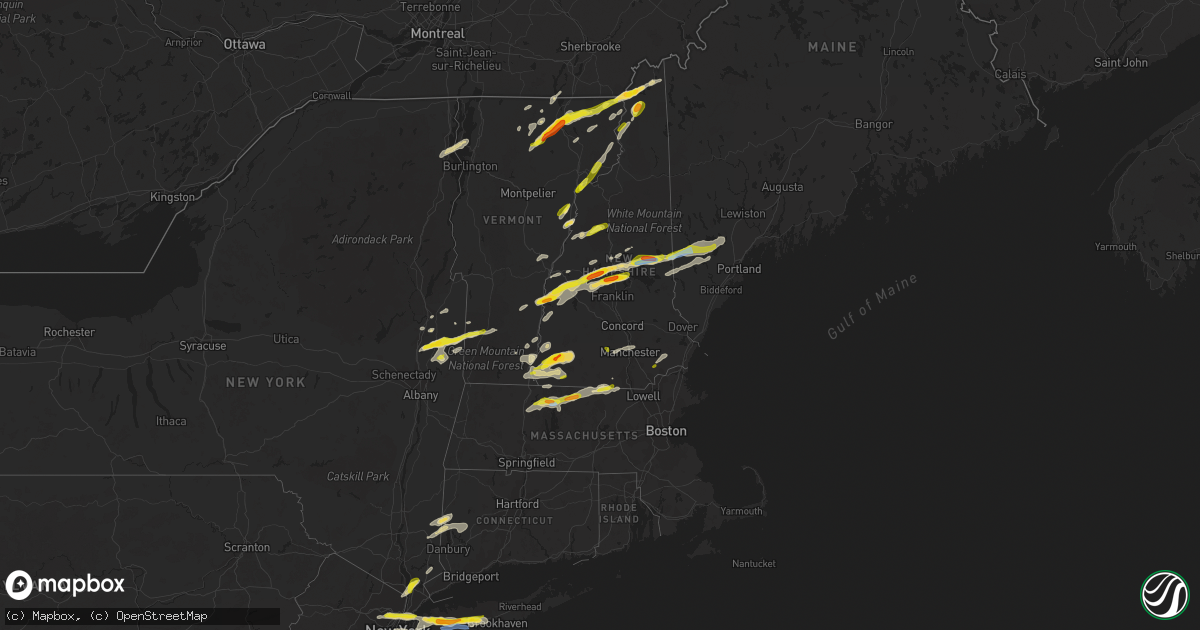
Hail Map in New Hampshire on July 21, 2022
Get this storm
July 21 map
$229
one time, instant access
Download today. No call, no setup
Keep the $229
Bought the map and want the full workflow? Apply the entire $229 to a subscription within 7 days. None of it is wasted.
Every map, not just this one
This buys you this map. Subscription and you get every map we run, in the markets you choose from a few cities to whole states to nationwide. Plus real-time alerts the moment a storm fires.
Contact data
Name, contact info, occupancy, even credit band for addresses in the footprint. You go from where it hit to who to call.
Become the source they trust
Unlimited branding weather history reports on demand. You already have the documented answer ready for the property owner, and you are the one who showed up with it.
Property data and RoofTrace estimates
Pull up any address you have got, its value and the exact code rules for that jurisdiction, straight from One Click Code. Then RoofTrace estimates the squares, pitch, and roof value, priced the way you price.
Storm reports in New Hampshire
New Hampshire
| Date | Description |
|---|---|
| 07/21/20225:17 PM CDT | Tree on road. Time estimated by radar. |
| 07/21/20225:04 PM CDT | Tree and wire down. Time estimated by radar. |
| 07/21/20224:28 PM CDT | Trees and branches down on streets between west swanzey and swanzey. Time estimated by radar. |
| 07/21/20224:28 PM CDT | Tree on line in driveway. |
| 07/21/20224:19 PM CDT | Large branch and wires down on south st. In portsmouth. Time estimated based on radar. |
| 07/21/20224:14 PM CDT | Large tree down... Wrapped in wires. Time estimated by radar. |
| 07/21/20224:10 PM CDT | Several trees and wires down. Time estimated by radar. |
| 07/21/20224:04 PM CDT | Report from mping: 1-inch tree limbs broken; shingles blown off. Time estimated by radar. |
| 07/21/20223:50 PM CDT | Wires down. Time estimated by radar. |
| 07/21/20223:45 PM CDT | Observed 1 inch hail near wash pond in hampstead at 4:45. |
| 07/21/20223:38 PM CDT | Tree on line. Time estimated by radar. |
| 07/21/20223:34 PM CDT | Public reported 1 inch hail. Time estimated by radar. |
| 07/21/20223:30 PM CDT | Wires down. Time estimated by radar. |
| 07/21/20223:30 PM CDT | Hail fell in west brookline just west of highway 31 at the entrance to potanipo lake. Time estimated by radar. |
| 07/21/20223:24 PM CDT | Storm w/ gusty winds and 1-inch hail impacted south hooksett east of route 28. Time estimated by radar. |
| 07/21/20223:21 PM CDT | Thunderstorm winds knocked down several branches... Blew over barrels near the hollis post office. |
| 07/21/20223:20 PM CDT | Wires down. Time estimated by radar. |
| 07/21/20223:18 PM CDT | Tree on wire. Time estimated by radar. |
| 07/21/20223:18 PM CDT | Wires down. Time estimated by radar. |
| 07/21/20223:14 PM CDT | Wires down. Time estimated by radar. |
| 07/21/20223:14 PM CDT | Trees and wires down on roadway. Time estimated by radar. |
| 07/21/20223:14 PM CDT | Wires down. Time estimated by radar. Country club on the west side of nashville. A portion of the roof was also removed from the cou |
| 07/21/20223:13 PM CDT | Five snapped power poles on hooksett rd. Time estimated by radar. |
| 07/21/20223:08 PM CDT | Telephone pole blown down. Time estimated by radar. |
| 07/21/20223:08 PM CDT | Hl159 reported trees and wires down. Time estimated by radar. |
| 07/21/20223:05 PM CDT | Wires down. Time estimated by radar. |
| 07/21/20223:04 PM CDT | Wires down. Time estimated by radar. |
| 07/21/20223:00 PM CDT | Delayed report. Tree down across interstate 89. Time estimated from radar. |
| 07/21/20222:58 PM CDT | 1-inch hail lasted 5-6 minutes. Gusty winds blew down several branches across the area. Time estimated by radar. |
| 07/21/20222:54 PM CDT | Wires down. Time estimated by radar. |
| 07/21/20222:40 PM CDT | Wires down. Time estimated by radar. |
| 07/21/20222:38 PM CDT | Delayed report. Multiple trees and large limbs down. Via twitter with pictures. Time estimated via radar. |
| 07/21/20222:35 PM CDT | Microburst damage extends along a roughly 4 mile path parallel to town house road. Estimated wind speeds of 80 mph. 300-400 trees down including softwoods and hardwoods |
| 07/21/20222:34 PM CDT | Trees and wires down. Time estimated by radar. |
| 07/21/20222:32 PM CDT | Branches and a few small trees down along a stretch of nh highway 119. Time estimated by radar. |
| 07/21/20222:30 PM CDT | Tree down. |
| 07/21/20222:28 PM CDT | Trees down in roadway. Time estimated by radar. |
| 07/21/20222:28 PM CDT | Trees and wires down in roadway. Time estimated by radar. |
| 07/21/20222:26 PM CDT | Hailstones the size of quarters in fitzwilliam along rte 12n. Time estimated by radar. |
| 07/21/20222:24 PM CDT | 1.5 inchers; hail fell for 5 mins south of clarksville. Damage to a shed. Strong winds blew down branches. Approximately 2:10pm. |
| 07/21/20222:22 PM CDT | Reported by weather spotter: hail lasted for about 5 minutes. Most stones were quarter-sized... But quite a few as large as half dollars. |
| 07/21/20222:14 PM CDT | Trees down. Time estimated by radar. |
| 07/21/20222:12 PM CDT | Observed golf ball sized hail north of sanbornton on pinnacle hill rd. Winds knocked down numerous branches and blew around loose objects. Time estimated by radar. |
| 07/21/20222:10 PM CDT | Tree on line. Time estimated by radar. |
| 07/21/20222:06 PM CDT | Multiple trees down. Time estimated by river. |
| 07/21/20222:06 PM CDT | Delayed report. Multiple trees down at bald peak cc. Via facebook. Time estimated via radar. |
| 07/21/20222:05 PM CDT | Winona rd in new hampton is closed due to downed wires and trees. |
| 07/21/20222:05 PM CDT | Winona rd in new hampton is closed due to downed wires and tree |
| 07/21/20222:04 PM CDT | Multiple trees down. |
| 07/21/20222:02 PM CDT | Reported by weather spotter. Golf ball-sized hail caused damage to minor vehicle hood. Hail fell on east side of keene just off of nh hwy 101. Time estimated by radar. |
| 07/21/20222:00 PM CDT | Tree down on nh-25. Time estimated by radar. |
| 07/21/20221:58 PM CDT | Trees and wires down. Time estimated by radar. |
| 07/21/20221:56 PM CDT | Hail as big as half dollars fell at the market basket on the south side of keene. |
| 07/21/20221:54 PM CDT | Tree on wires. Time estimated by radar. |
| 07/21/20221:40 PM CDT | Non-nws meteorologist reported tree down on interstate 93. Time estimated by radar. |
| 07/21/20221:39 PM CDT | Non-nws meteorologist reported trees on wires. Time estimated by radar. |
| 07/21/20221:38 PM CDT | Wires down. Time estimated by radar. |
| 07/21/20221:36 PM CDT | Delayed report. Multiple trees down and half dollar sized hail. Time estimated by radar. |
| 07/21/20221:36 PM CDT | Reported by amateur radio: ping pong sized hail fell for about minutes. Observed from route 3a. Reports of some minor damage. Time estimated by radar. |
| 07/21/20221:36 PM CDT | Wires down. Time estimated by radar. |
| 07/21/20221:32 PM CDT | Delayed report. Multiple trees down in bristol. Time estimated by radar. |
| 07/21/20221:32 PM CDT | Reported by weather spotter: trained spotter observed 1.25 inch hail in downtown hinsdale near intersection of nh 119 and nh 63. |
| 07/21/20221:28 PM CDT | Several large branches down across nh highway 10 in croydon. Time estimated by radar. |
| 07/21/20221:15 PM CDT | Numerous trees down on west rd east of us hwy 3 split. Photos on social media. |
| 07/21/20221:12 PM CDT | Corrected previous report for time. One inch hail reported in pittsburg... Nh. Picture posted on social media. |
| 07/21/20221:12 PM CDT | Measured hail between 1.3-1.5 inches in diameter. Hail lasted 6 minutes and covered some grassy areas. |
| 07/21/20221:08 PM CDT | Delayed report. One tree down on wires. Time estimated by radar. |
| 07/21/20221:04 PM CDT | Tree down-reported by new england 511. Time estimated by radar. |
| 07/21/202212:56 PM CDT | Large tree down on shoulder of nh highway 10 north of lyme. Diameter ~12 inches. Time estimated by radar. |
| 07/21/202212:54 PM CDT | Delayed report. Multiple reports of trees down and trees on wire throughout town. Time estimated by radar. |
| 07/21/202212:50 PM CDT | Reported by weather spotter: observed hail between 1.25 inches and 1.5 inches; in w. Claremont. Occurred at approx 1:50pm. |
| 07/21/202212:12 PM CDT | Severe hail of 1 inch reported in pittsburgh with picture evidence. |
| 07/21/202212:46 AM CDT | At 546 PM EDT, a severe thunderstorm was located over Lewis, moving east at 40 mph. HAZARD...60 mph wind gusts and quarter size hail. SOURCE...Radar indicated. IMPACT...Minor hail damage to vehicles is possible. Expect wind damage to trees and powerlines. Locations impacted include... Island Pond, Canaan, Brunswick, Bloomfield, Brighton, Norton, Averill, Ferdinand, Warren Gore, Warners Grant, Lewis, Averys Gore, Newark, Lemington, Morgan, Westmore, Charleston, Holland, Beecher Falls and Connor Island. |
| 07/21/202212:19 AM CDT | At 519 PM EDT, severe thunderstorms were located along a line extending from Granville to Rochester to North Clarendon, moving east at 30 mph. HAZARD...60 mph wind gusts and quarter size hail. SOURCE...Radar indicated. IMPACT...Minor hail damage to vehicles is possible. Expect wind damage to trees and powerlines. Locations impacted include... Rutland, Woodstock, Braintree Hill, Bradford, Killington, Thetford Hill State Park, Rutland City, Lincoln, Pomfret, Plymouth, Thetford, Hartland, Chittenden, West Rutland, Granville, Fairlee, Tunbridge, Hancock, Sharon and Corinth Corners. |
| 07/20/202211:33 PM CDT | At 433 PM EDT, a severe thunderstorm was located over Walpole, or 10 miles north of Keene, moving east at 25 mph. HAZARD...60 mph wind gusts and quarter size hail. SOURCE...Radar indicated. IMPACT...Hail damage to vehicles is expected. Expect wind damage to roofs, siding, and trees. Locations impacted include... Charlestown, Antrim, Nelson, Gilsum, Marlow, Walpole, Sullivan, Alstead, Surry, Windsor, Lempster, Acworth, Langdon and Washington. |
| 07/20/202211:14 PM CDT | At 414 PM EDT, a severe thunderstorm was located over Ashby, or 7 miles north of Fitchburg, moving east at 35 mph. HAZARD...60 mph wind gusts and penny size hail. SOURCE...Radar indicated. IMPACT...Expect damage to trees and power lines. Locations impacted include... Lowell, Methuen, Fitchburg, Andover, Dracut, Pepperell, Tyngsborough, Groton, Lunenburg, Townsend, Shirley, Ashburnham, Dunstable and Ashby. |
| 07/20/202211:12 PM CDT | At 411 PM EDT, a severe thunderstorm was located near Danbury, or 8 miles northwest of Franklin, moving east at 35 mph. HAZARD...60 mph wind gusts and quarter size hail. SOURCE...Radar indicated. IMPACT...Hail damage to vehicles is expected. Expect wind damage to roofs, siding, and trees. Locations impacted include... Laconia, Franklin, Meredith, Moultonborough, Ossipee, Grafton, Alton, Gilmanton, Holderness, Danbury, Wolfeboro, Belmont, Gilford, Bristol, Andover, Alexandria, Center Harber, Hill, Bridgewater and Tuftonboro.This includes Interstate 93 between mile markers 56 and 73. |
| 07/20/202211:08 PM CDT | At 407 PM EDT, a severe thunderstorm was located near Goffstown, or near Manchester, moving east at 35 mph. HAZARD...60 mph wind gusts and quarter size hail. SOURCE...Radar indicated. IMPACT...Hail damage to vehicles is expected. Expect wind damage to roofs, siding, and trees. Locations impacted include... Manchester, Northwood, Bedford, Hooksett, Barrington, Epping, Epsom, Raymond, Goffstown, Newmarket, Bow, Chester, Allenstown, Deerfield, Candia, Dunbarton, Nottingham, Pembroke and Strafford.This includes the following highways... Interstate 293 between mile markers 1 and 11. Interstate 93 between mile markers 19 and 33. |
| 07/20/202210:24 PM CDT | At 324 PM EDT, a severe thunderstorm was located near Ossipee, moving east at 40 mph. HAZARD...Ping pong ball size hail and 60 mph wind gusts. SOURCE...Radar indicated. IMPACT...People and animals outdoors will be injured. Expect hail damage to roofs, siding, windows, and vehicles. Expect wind damage to roofs, siding, and trees. Locations impacted include... Bridgton, Ossipee, Naples, Buxton, Hollis, Hiram, Effingham, Cornish, Standish, Wolfeboro, Waterboro, Limington, Limerick, Brownfield, Freedom, Denmark, Eaton, Parsonsfield, Sebago and Baldwin. |
| 07/20/202210:08 PM CDT | At 308 PM EDT, a severe thunderstorm was located over Harrisville, or 10 miles north of Jaffrey, moving east at 35 mph. HAZARD...Ping pong ball size hail and 60 mph wind gusts. SOURCE...Radar indicated. IMPACT...People and animals outdoors will be injured. Expect hail damage to roofs, siding, windows, and vehicles. Expect wind damage to roofs, siding, and trees. Locations impacted include... Manchester, Concord, Henniker, Hooksett, Peterborough, Hopkinton, New Boston, Antrim, Greenfield, Lyndeborough, Francestown, Bennington, Harrisville, Windsor, Hancock, Goffstown, Deering, Hillsborough, Weare and Bow.This includes the following highways... Interstate 293 between mile markers 8 and 11. Interstate 89 between mile markers 3 and 13. Interstate 93 between mile markers 23 and 26. |
| 07/20/20229:51 PM CDT | At 251 PM EDT, a severe thunderstorm was located near Meredith, moving east at 45 mph. HAZARD...60 mph wind gusts and half dollar size hail. SOURCE...Radar indicated. IMPACT...Hail damage to vehicles is expected. Expect wind damage to roofs, siding, and trees. Locations impacted include... Conway, Ossipee, Moultonborough, Effingham, Sandwich, Tamworth, Wolfeboro, Madison, Freedom, Eaton and Tuftonboro. |
| 07/20/20229:28 PM CDT | At 227 PM EDT, a severe thunderstorm was located near Chesterfield, or 11 miles southwest of Keene, moving northeast at 35 mph. HAZARD...60 mph wind gusts and quarter size hail. SOURCE...Radar indicated. IMPACT...Hail damage to vehicles is expected. Expect wind damage to roofs, siding, and trees. Locations impacted include... Keene, Jaffrey, Winchester, Antrim, Dublin, Richmond, Harrisville, Nelson, Gilsum, Marlborough, Walpole, Alstead, Westmoreland, Swanzey, Marlow, Hinsdale, Roxbury, Troy, Sullivan and Chesterfield. |
| 07/20/20229:26 PM CDT | At 226 PM EDT, a severe thunderstorm was located 8 miles east of Piermont, or 14 miles southwest of Lincoln, moving east at 30 mph. HAZARD...60 mph wind gusts and quarter size hail. SOURCE...Radar indicated. IMPACT...Hail damage to vehicles is expected. Expect wind damage to roofs, siding, and trees. Locations impacted include... Bethlehem, Lincoln, Haverhill, Franconia, Woodstock, Piermont, Benton, Easton, Ellsworth, Wentworth, Livermore, Thornton, Waterville Valley, Campton, Rumney and Orford.This includes Interstate 93 between mile markers 89 and 107. |
| 07/20/20229:23 PM CDT | At 223 PM EDT, severe thunderstorms were located along a line extending from near Grafton to 6 miles northeast of Newport, moving northeast at 25 mph. HAZARD...Ping pong ball size hail and 60 mph wind gusts. SOURCE...Radar indicated. IMPACT...People and animals outdoors will be injured. Expect hail damage to roofs, siding, windows, and vehicles. Expect wind damage to roofs, siding, and trees. Locations impacted include... Laconia, Franklin, New London, Plymouth, Meredith, Moultonborough, Grafton, Alton, Gilmanton, Holderness, Ashland, Danbury, Groton, Sandwich, Belmont, Gilford, Bristol, Grantham, Andover and Alexandria.This includes the following highways... Interstate 89 between mile markers 34 and 42. Interstate 93 between mile markers 57 and 80. |
| 07/20/20228:47 PM CDT | At 147 PM EDT, a severe thunderstorm was located over Topsham Four Corners, moving northeast at 30 mph. HAZARD...60 mph wind gusts and quarter size hail. SOURCE...Radar indicated. IMPACT...Minor hail damage to vehicles is possible. Expect wind damage to trees and powerlines. Locations impacted include... St. Johnsbury, Waterford, Topsham Four Corners, Wells River Village, Ryegate, Newbury, Newbury Village, Barnet, Concord, Lower Waterford, Topsham, Groton Village, Kirby, Bradford, Corinth, Danville, Groton, Wells River, St. Johnsbury Center and Concord Corner. |
| 07/20/20228:33 PM CDT | At 132 PM EDT, a severe thunderstorm was located 7 miles north of Newport, or 8 miles northeast of Claremont, moving east at 30 mph. HAZARD...60 mph wind gusts and quarter size hail. SOURCE...Radar indicated. IMPACT...Hail damage to vehicles is expected. Expect wind damage to roofs, siding, and trees. Locations impacted include... Claremont, Lebanon, Franklin, New London, Plymouth, Grafton, Enfield, Canaan, Danbury, Groton, Newport, Bristol, Grantham, Andover, Cornish, Hill, Croydon, Hebron, Plainfield and Orange.This includes Interstate 89 between mile markers 31 and 51. |
| 07/20/20228:27 PM CDT | At 126 PM EDT, a severe thunderstorm was located over Lewis, moving east at 35 mph. HAZARD...60 mph wind gusts and nickel size hail. SOURCE...Radar indicated. IMPACT...Expect damage to trees and powerlines. Locations impacted include... Island Pond, Canaan, Bloomfield, Brighton, Norton, Morgan, Averill, Warren Gore, Warners Grant, Lewis, Averys Gore, Lemington, Holland, Charleston, Newark, Ferdinand, Brunswick, Beecher Falls, Morgan Center and East Brighton. |
All States Impacted by Hail Map on July 21, 2022
Cities Impacted by Hail Map on July 21, 2022
- Vienna, SD
- Bryant, SD
- Jamestown, ND
- Ipswich, SD
- Roscoe, SD
- East Charleston, VT
- Eden Mills, VT
- Irasburg, VT
- Morgan, VT
- Orleans, VT
- Averill, VT
- Wolcott, VT
- West Stewartstown, NH
- Norton, VT
- Island Pond, VT
- Newport, VT
- Hyde Park, VT
- West Charleston, VT
- Pittsburg, NH
- Albany, VT
- Beecher Falls, VT
- Craftsbury, VT
- Barton, VT
- Craftsbury Common, VT
- Colebrook, NH
- Canaan, VT
- Wheatland, ND
- Buffalo, ND
- Salem, NY
- Dupree, SD
- Eagle Butte, SD
- Edgeley, ND
- Ashley, ND
- Forbes, ND
- Roslyn, SD
- Mandan, ND
- Langford, SD
- Lehr, ND
- Kintyre, ND
- Moffit, ND
- Sterling, ND
- Bismarck, ND
- Ellendale, ND
- Napoleon, ND
- Braddock, ND
- Hecla, SD
- Claremont, SD
- Britton, SD
- Eden, SD
- Wishek, ND
- Kulm, ND
- Amherst, SD
- Frederick, SD
- Oakes, ND
- Menoken, ND
- Fredonia, ND
- Eustis, ME
- Richford, VT
- Montgomery Center, VT
- Timber Lake, SD
- New Salem, ND
- Tahlequah, OK
- Browns Summit, NC
- Pardeeville, WI
- Rio, WI
- Poynette, WI
- Columbus, WI
- Turton, SD
- Doland, SD
- Mellette, SD
- Raymond, SD
- Ashton, SD
- Conde, SD
- Onaka, SD
- Warner, SD
- Selby, SD
- Saint Anthony, ND
- Java, SD
- Hazelton, ND
- Northville, SD
- Bowdle, SD
- Flasher, ND
- Hague, ND
- Eureka, SD
- Leola, SD
- Tolstoy, SD
- Hosmer, SD
- Mansfield, SD
- Westport, SD
- Zeeland, ND
- Aberdeen, SD
- Cannon Ball, ND
- Strasburg, ND
- Linton, ND
- Hoven, SD
- Solen, ND
- Almont, ND
- Glen Ullin, ND
- Big Falls, MN
- Greenville Junction, ME
- Greenville, ME
- Shirley Mills, ME
- Monson, ME
- Abbot, ME
- Marion, ND
- Litchville, ND
- Spiritwood, ND
- Kathryn, ND
- Sanborn, ND
- Hebron, ND
- Beulah, ND
- South Hero, VT
- Peru, NY
- Keeseville, NY
- Fort Edward, NY
- Hudson Falls, NY
- Argyle, NY
- Fort Ann, NY
- Stuart, NE
- Putney, VT
- Westminster, VT
- Phil Campbell, AL
- Haleyville, AL
- Bear Creek, AL
- Claremont, NH
- Charlestown, NH
- Dewitt, VA
- Wilsons, VA
- McKenney, VA
- Steele, ND
- Tappen, ND
- Dawson, ND
- Ypsilanti, ND
- Montpelier, ND
- Newport Center, VT
- North Platte, NE
- Maxwell, NE
- West Newfield, ME
- Parsonsfield, ME
- Limerick, ME
- Standish, ME
- East Wakefield, NH
- Steep Falls, ME
- Limington, ME
- Sanbornville, NH
- Saint Johnsbury, VT
- Monroe, NH
- Littleton, NH
- North Stratford, NH
- Lawrenceville, VA
- Rosston, OK
- Gansevoort, NY
- Schuylerville, NY
- Belvidere Center, VT
- Rockford, MI
- Conklin, MI
- Marne, MI
- Coopersville, MI
- Belmont, MI
- Grand Rapids, MI
- Comstock Park, MI
- Hartford, SD
- Humboldt, SD
- Council Bluffs, IA
- Pipestone, MN
- Newfane, VT
- Perryton, TX
- Hudson, SD
- Champion, NE
- Imperial, NE
- Callaway, NE
- Gothenburg, NE
- Chesterfield, VA
- Henrico, VA
- Pawnee, OK
- Roxbury, CT
- Bridgewater, CT
- Woodbury, CT
- Washington, CT
- Pawling, NY
- Holmes, NY
- Patterson, NY
- New Milford, CT
- Carmel, NY
- Sherman, CT
- Genoa, NE
- Columbus, NE
- Monroe, NE
- Sandston, VA
- Hodgen, OK
- Perry, OK
- Alstead, NH
- Keene, NH
- Westmoreland, NH
- Walpole, NH
- Bryant, AL
- Trenton, GA
- Rose, OK
- Lewisburg, TN
- Jasper, TN
- South Pittsburg, TN
- Lake Village, AR
- Anniston, AL
- West Point, MS
- Cedarbluff, MS
- Anderson, AL
- Lexington, AL
- Hope Hull, AL
- Montgomery, AL
- Centreville, AL
- Brent, AL
- Stigler, OK
- Forest, MS
- Lena, MS
- Mayersville, MS
- McCool, MS
- Louisville, MS
- Macon, GA
- Riverside, AL
- Pell City, AL
- Kosciusko, MS
- Eatonton, GA
- Buffalo, OK
- Forsyth, GA
- Barnesville, GA
- Marion, AL
- Mena, AR
- Collins, MS
- Buhl, AL
- Eutaw, AL
- Aliceville, AL
- Gordo, AL
- Ralph, AL
- Knoxville, AL
- Boligee, AL
- Attalla, AL
- Gadsden, AL
- Moundville, AL
- Akron, AL
- Phenix City, AL
- Hamilton, AL
- Livingston, LA
- Nashville, AR
- McCaskill, AR
- Murfreesboro, AR
- De Kalb, MS
- Warren, NH
- Franklin, GA
- Hogansville, GA
- Tyler, AL
- Lowndesboro, AL
- Lake, MS
- Sebago, ME
- East Baldwin, ME
- Roland, OK
- Muldrow, OK
- Thomaston, GA
- Spiro, OK
- Seale, AL
- Vian, OK
- Bunch, OK
- Cookson, OK
- Sallisaw, OK
- Marion Junction, AL
- Fort Mitchell, AL
- Bowling Green, FL
- Pittsview, AL
- Labelle, FL
- Oakman, AL
- Vaiden, MS
- Brattleboro, VT
- West Chesterfield, NH
- South Ryegate, VT
- Newbury, VT
- Adger, AL
- Broken Arrow, OK
- Catherine, AL
- Pine Hill, AL
- Miami, AZ
- Globe, AZ
- Wingdale, NY
- Gaylordsville, CT
- Brookings, SD
- Houghton, SD
- West Forks, ME
- Brookline, NH
- Reidsville, NC
- Sparkman, AR
- Stilwell, OK
- Tuscumbia, AL
- Cherokee, AL
- Florence, AL
- Umpire, AR
- Wickes, AR
- Gurdon, AR
- Arkadelphia, AR
- Prescott, AR
- Sylacauga, AL
- Birmingham, AL
- Shelby, AL
- Sterrett, AL
- Columbiana, AL
- Chelsea, AL
- Wilsonville, AL
- Hollandale, MS
- Eudora, AR
- Loving, NM
- Reform, AL
- Cottondale, AL
- Tuscaloosa, AL
- Lafayette, AL
- Waverly, AL
- Dermott, AR
- Berry, AL
- Northport, AL
- Glenwood, AR
- Caddo Gap, AR
- Pleasant Grove, AL
- Dolomite, AL
- Fairfield, AL
- Bessemer, AL
- East Corinth, VT
- Topsham, VT
- Wells River, VT
- Center Ossipee, NH
- Effingham, NH
- Grantham, NH
- Windsor, VT
- Enfield, NH
- Raymond, ME
- West Baldwin, ME
- Center Tuftonboro, NH
- Plainfield, NH
- Cornish, NH
- Springfield, VT
- Hill, NH
- Ossipee, NH
- Meredith, NH
- Canaan, NH
- Laconia, NH
- Perkinsville, VT
- Ascutney, VT
- Moultonborough, NH
- Danbury, NH
- Holderness, NH
- Center Harbor, NH
- Windham, ME
- Bristol, NH
- New London, NH
- New Hampton, NH
- Newport, NH
- Wilmot, NH
- Gray, ME
- Sanbornton, NH
- Sunapee, NH
- Cornish, ME
- Grafton, NH
- Springfield, NH
- Hiram, ME
- Plymouth, NH
- Belgrade, NE
- Cedar Rapids, NE
- Eau Claire, MI
- Elkhart, IN
- Bristol, IN
- Berrien Center, MI
- Granger, IN
- Niles, MI
- Dowagiac, MI
- Sodus, MI
- Watervliet, MI
- Osceola, IN
- Saint Joseph, MI
- Stevensville, MI
- Cassopolis, MI
- Middlebury, IN
- Edwardsburg, MI
- Goshen, IN
- Hartford, MI
- Coloma, MI
- Benton Harbor, MI
- Union, MI
- Proctorsville, VT
- Cavendish, VT
- Chester, VT
- Sutherland, VA
- Church Road, VA
- Petersburg, VA
- Bayside, NY
- Fairview, NJ
- Passaic, NJ
- Queens Village, NY
- Glen Ridge, NJ
- Palisades Park, NJ
- Hicksville, NY
- Greenvale, NY
- Wood Ridge, NJ
- Port Washington, NY
- Commack, NY
- Bloomfield, NJ
- Bay Shore, NY
- Fresh Meadows, NY
- Montclair, NJ
- Nutley, NJ
- Islip Terrace, NY
- Farmingville, NY
- Bohemia, NY
- New York, NY
- Jamaica, NY
- Little Neck, NY
- Roslyn Heights, NY
- Medford, NY
- East Islip, NY
- Teterboro, NJ
- Oakland Gardens, NY
- New Hyde Park, NY
- Williston Park, NY
- Mineola, NY
- Rutherford, NJ
- Huntington, NY
- Islip, NY
- Ronkonkoma, NY
- Albertson, NY
- Farmingdale, NY
- Holtsville, NY
- Glen Oaks, NY
- Roslyn, NY
- Woodbury, NY
- Holbrook, NY
- Old Bethpage, NY
- Wallington, NJ
- Deer Park, NY
- Huntington Station, NY
- North Bergen, NJ
- Floral Park, NY
- Patchogue, NY
- Jericho, NY
- Edgewater, NJ
- Moonachie, NJ
- Hollis, NY
- Wyandanch, NY
- Plainview, NY
- Bronx, NY
- East Rutherford, NJ
- Bayport, NY
- Bethpage, NY
- Hauppauge, NY
- Glen Head, NY
- Hasbrouck Heights, NJ
- Central Islip, NY
- Cliffside Park, NJ
- Ridgefield Park, NJ
- Sayville, NY
- Melville, NY
- Islandia, NY
- Bellerose, NY
- Flushing, NY
- Syosset, NY
- Ridgefield, NJ
- Carlstadt, NJ
- Little Ferry, NJ
- Manhasset, NY
- Great Neck, NY
- Brentwood, NY
- Lyndhurst, NJ
- Fort Lee, NJ
- Westbury, NY
- Old Westbury, NY
- Clifton, NJ
- Fremont, NE
- Valley, NE
- Yutan, NE
- Howe, OK
- Poteau, OK
- Locust Grove, OK
- Bethlehem, CT
- Watertown, CT
- Porum, OK
- Marlborough, NH
- Chesterfield, NH
- Nelson, NH
- Hinsdale, NH
- Spofford, NH
- Dublin, NH
- Harrisville, NH
- Ashuelot, NH
- Winchester, NH
- Troy, NH
- Vernon, VT
- Sullivan, NH
- Fitzwilliam, NH
- Swanzey, NH
- Rainbow City, AL
- Temple, GA
- Muskogee, OK
- Braggs, OK
- Morrison, OK
- Aberdeen, MS
- Gans, OK
- Keota, OK
- Killen, AL
- Rogersville, AL
- Courtland, AL
- Town Creek, AL
- Mount Hope, AL
- Leighton, AL
- Russellville, AL
- Sturgis, MS
- Ackerman, MS
- Parrish, AL
- Townley, AL
- Faunsdale, AL
- Oxford, AL
- Munford, AL
- Cove, AR
- Hatfield, AR
- Leeds, AL
- Taylorsville, MS
- Mize, MS
- Gallant, AL
- Oneonta, AL
- Altoona, AL
- Salem, AL
- Opelika, AL
- Fitzpatrick, AL
- Hardaway, AL
- Union Springs, AL
- Moody, AL
- Vincent, AL
- Talladega, AL
- Cropwell, AL
- Harpersville, AL
- Childersburg, AL
- Alpine, AL
- Odenville, AL
- Enterprise, MS
- Perrin, TX
- Prattville, AL
- Union, MS
- Philadelphia, MS
- Fullerton, ND
- Uniontown, AL
- Beresford, SD
- Checotah, OK
- Sutton, VT
- Lennox, SD
- Douglas, AZ
- Orford, NH
- Piermont, NH
- Wentworth, NH
- Lebanon, SD
- Parker, SD
- Tea, SD
- Chancellor, SD
- Valley, AL
- Cusseta, AL
- Lauderdale, MS
- Toomsuba, MS
- Westfield, VT
- Arlington, SD
- Lake Preston, SD
- Bruce, SD
- Erwin, SD
- Volga, SD
- Willow Lake, SD
- De Smet, SD
- Mendon, MI
- Townsend, MA
- Greenville, NH
- Ashby, MA
- West Townsend, MA
- Ashburnham, MA
- David City, NE
- Malmo, NE
- Linwood, NE
- Morse Bluff, NE
- Schuyler, NE
- Colon, NE
- Prague, NE
- Cedar Bluffs, NE
- Rogers, NE
- Bellwood, NE
- Hyannis, NE
- Cambridge, NY
- Buskirk, NY
- Eagle Bridge, NY
- Grayslake, IL
- Libertyville, IL
- Lake Forest, IL
- Highland Park, IL
- Lake Bluff, IL
- Mundelein, IL
- Castana, IA
- Onawa, IA
- Arlington, VT
- Saratoga Springs, NY
- Greenwich, NY
- Stillwater, NY
- Shushan, NY
- Tulsa, OK
- Bronson, IA
- Mullen, NE
- Seneca, NE
- Locust Fork, AL
- Trafford, AL
- Remlap, AL
- Norwood, NJ
- Nyack, NY
- Elmsford, NY
- Piermont, NY
- Northvale, NJ
- Tarrytown, NY
- Pleasantville, NY
- Irvington, NY
- Orangeburg, NY
- Valhalla, NY
- Palisades, NY
- Thornwood, NY
- Sparkill, NY
- Tappan, NY
- Alpine, NJ
- Hawthorne, NY
- Enders, NE
- Columbia, NC
- Dierks, AR
- Orange City, IA
- Maurice, IA
- Alton, IA
- Le Mars, IA
- Sioux Center, IA
- Ireton, IA
- McCalla, AL
- Montevallo, AL
- West Blocton, AL
- Dora, AL
- Fultondale, AL
- Mount Olive, AL
- Brierfield, AL
- Docena, AL
- Gardendale, AL
- Quinton, AL
- Helena, AL
- Mulga, AL
- Cordova, AL
- Alabaster, AL
- Adamsville, AL
- Brookwood, AL
- Hillsboro, AL
- Ozan, AR
- Hurtsboro, AL
- Sparta, GA
- Kennedy, AL
- Lincoln, AL
- Amity, AR
- Delta, AL
- Wedowee, AL
- Lineville, AL
- Claude, TX
- Warrior, AL
- Kimberly, AL
- Morris, AL
- Maben, MS
- Pheba, MS
- Orrville, AL
- Columbia, SD
- Arlington, AL
- Maplesville, AL
- Clanton, AL
- Billingsley, AL
- Plantersville, AL
- Concord, VT
- Granby, VT
- Lunenburg, VT
- Guildhall, VT
- North Concord, VT
- Cameron, OK
- Hackett, AR
- Redfield, SD
- Elkhorn, NE
- Exeter, NH
- Kingston, NH
- Sandown, NH
- Fremont, NH
- Danville, NH
- Anselmo, NE
- Jarratt, VA
- Emporia, VA
- Coldwater, MI
- Tekonsha, MI
- Quincy, MI
- Bradford, VT
- Valley Falls, NY
- Schaghticoke, NY
- Johnsonville, NY
- Decatur, MI
- Blevins, AR
- Kent, CT
- South Kent, CT
- West Point, GA
- Tremont, MS
- Detroit, AL
- Smithville, MS
- Beaverton, AL
- Sulligent, AL
- Gattman, MS
- Caledonia, MS
- Greenwood Springs, MS
- Amory, MS
- Woodland, AL
- Graham, AL
- Ranburne, AL
- Rosston, AR
- Gallion, AL
- Forkland, AL
- Livingston, AL
- Cuba, AL
- York, AL
- Demopolis, AL
- Greensboro, AL
- West Burke, VT
- West Rupert, VT
- Safford, AL
- Chidester, AR
- Ashland, NH
- Wolbach, NE
- Ansley, NE
- Broken Bow, NE
- Oconto, NE
- Mason City, NE
- Merna, NE
- Arriba, CO
- Catoosa, OK
- Atkinson, NE
- Winchendon, MA
- Athol, MA
- Baldwinville, MA
- Correctionville, IA
- Pierson, IA
- Greenwood, MS
- Sidon, MS
- Idalia, CO
- Colonial Heights, VA
- Bearden, AR
- Vicksburg, MI
- Schoolcraft, MI
- Portage, MI
- Rock Island, TN
- Muscle Shoals, AL
- Steele, AL
- Springville, AL
- Tchula, MS
- Lexington, MS
- Starkville, MS
- Macon, MS
- South Deerfield, MA
- Orange, MA
- Lake Pleasant, MA
- Deerfield, MA
- Royalston, MA
- Erving, MA
- Warwick, MA
- Wendell Depot, MA
- Pepperell, MA
- Gardner, MA
- Hollis, NH
- Petersham, MA
- Millers Falls, MA
- Montague, MA
- New Salem, MA
- Wendell, MA
- Minter, AL
- Brady, NE
- Dinwiddie, VA
- Springer, NM
- Hooksett, NH
- Manchester, NH
- Goffstown, NH
- Auburn, NH
- New Boston, NH
- Mcminnville, TN
- Hereford, TX
- Wildorado, TX
- Delight, AR
- Nettleton, MS
- Petersburg, TX
- Idalou, TX
- Abernathy, TX
- Davis, SD
- Mineral Springs, AR
- Lockesburg, AR
- Jacksboro, TX
- Claypool, AZ
- Newbern, AL
- Walker, LA
- Haverhill, NH
- Rangeley, ME
- Cleveland, AL
- Hebron, NH
- Midway, AL
- Clayton, AL
- Lowell, VT
- Center Sandwich, NH
- Long Valley, SD
- Wanblee, SD
- Saint Francis, SD
- Parmelee, SD
- Norris, SD
- Meansville, GA
- The Rock, GA
- Worthing, SD
- Proctor, OK
- Trappe, MD
- East New Market, MD
- Cambridge, MD
- Arnold, NE
- Whitman, NE
- Merriman, NE
- Mead, NE
- Cleveland, ND
- Medina, ND
- Ashville, AL
- Frankfort, SD
- Sardis, AL
- Eastaboga, AL
- Eupora, MS
- Ocate, NM
- Walnut Grove, MS
- Hatchechubbee, AL
- Inverness, MS
- Isola, MS
- Letohatchee, AL
- Ethel, MS
- San Simon, AZ
- Hampton, AR
- Warren, AR
- Thornton, AR
- Banks, AR
- Raleigh, MS
- Mansfield, AR
- Booneville, AR
- Gillham, AR
- Berlin, MD
- Newark, MD
- Hayes, SD
- South Glens Falls, NY
- Raton, NM
- Snow Hill, MD
- Mishawaka, IN
- Cozad, NE
- Brodnax, VA
- Athens, AL
- Lester, AL
- Elkmont, AL
- Waldron, AR
- Fort Smith, AR
- Boles, AR
- Hartford, AR
- Pocola, OK
- Newhope, AR
- Summerville, GA
- Leesburg, AL
- Eden, VT
- Lebanon, NH
- Young, AZ
- Lexington, NE
- Eddyville, NE
- Payson, AZ
- Vandervoort, AR
- Collinsville, MS
- Lanett, AL
- Lagrange, GA
- Mathews, AL
- Cecil, AL
- Heflin, AL
- Carthage, MS
- Springfield, LA
- Stapleton, NE
- Hurley, SD
- Centerville, SD
- Rodeo, NM
- Thedford, NE
- Fullerton, NE
- King William, VA
- West Point, VA
- New Kent, VA
- Katonah, NY
- Mount Kisco, NY
- Bedford Hills, NY
- Bedford, NY
- Gore, OK
- Waterloo, NE
- Smithville, OK
- Bokoshe, OK
- Creswell, NC
- Carbon Hill, AL
- Fayette, AL
- Villa Rica, GA
- Carrollton, GA
- Parks, AR
- Bentonia, MS
- Fordyce, AR
- Harrell, AR
- Princess Anne, MD
- Wetumpka, AL
- Jasper, AL
- Woodland, MS
- Mantee, MS
- Lawley, AL
- Heavener, OK
- Coila, MS
- Louin, MS
- Carrollton, AL
- South Bend, TX
- Graham, TX
- Breckenridge, TX
- Trussville, AL
- De Queen, AR
- Van Buren, AR
- Stanton, AL
- Pinson, AL
- Millport, AL
- Lawrence, MS
- Newton, MS
- Rose Hill, MS
- Meridian, MS
- Chunky, MS
- Hickory, MS
- Williamsville, VT
- Guadalupita, NM
- Gainesville, AL
- Epes, AL
- Fosters, AL
- Roanoke, AL
- Shuqualak, MS
- Scooba, MS
- Yazoo City, MS
- Silver City, MS
- Benton, MS
- Fort Benning, GA
- Shady Point, OK
- Bondville, VT
- Manchester, VT
- Manchester Center, VT
- Ballston Spa, NY
- Chattanooga, TN
- Little Plymouth, VA
- Vina, AL
- Red Bay, AL
- Chester, VA
- Northfield, MA
- Belzoni, MS
- Stephens, AR
- Camden, AR
- Columbus, MS
- Coosada, AL
- Deatsville, AL
- Elmore, AL
- Five Points, AL
- Sharon, VT
- West Hartford, VT
- Norwich, VT
- North Pomfret, VT
- Gettysburg, SD
- White Pigeon, MI
- Jersey City, NJ
- Ridgewood, NY
- Brooklyn, NY
- Middle Village, NY
- Maspeth, NY
- Hamilton, MS
- Ramer, AL
- Winona, MS
- Ona, FL
- Bartow, FL
- Quitman, MS
- Elfrida, AZ
- Stratford, SD
- Wauneta, NE
- Briarcliff Manor, NY
- North Haverhill, NH
- Valentine, NE
- Center, ND
- Long Lake, SD
- Verona, ND
- Akaska, SD
- Porter, ME
- Sioux Falls, SD
- Chappaqua, NY
- Nesconset, NY
- Graysville, AL
- Pelham, AL
- Calera, AL
- Jemison, AL
- Goodwater, AL
- Kellyton, AL
- Weogufka, AL
- Rockford, AL
- Sparta, MI
- Gorham, ME
- Levittown, NY
- North Babylon, NY
- Great River, NY
- West Islip, NY
- Seaford, NY
- West Babylon, NY
- Massapequa, NY
- West Sayville, NY
- Brightwaters, NY
- Oakdale, NY
- Wantagh, NY
- North Woodstock, NH
- Weare, NH
- Hampstead, NH
- Atkinson, NH
- Bonnerdale, AR
- Halsey, NE


