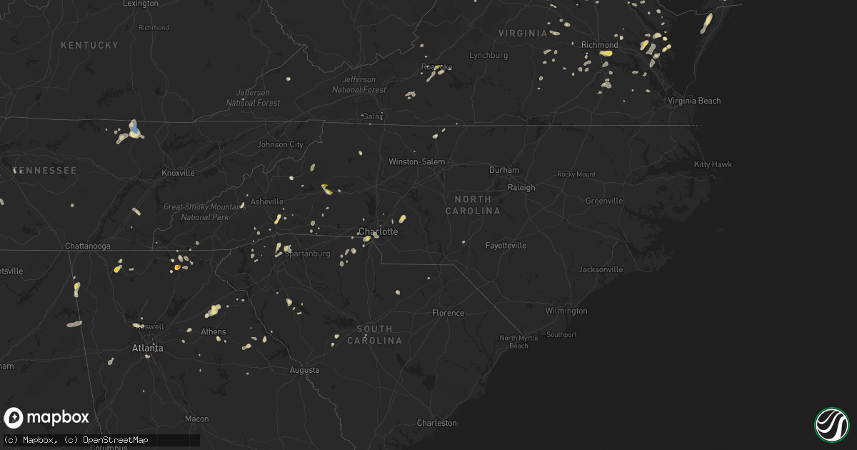
Hail Map in North Carolina on July 21, 2020
Get this storm
July 21 map
$229
one time, instant access
Download today. No call, no setup
Keep the $229
Bought the map and want the full workflow? Apply the entire $229 to a subscription within 7 days. None of it is wasted.
Every map, not just this one
This buys you this map. Subscription and you get every map we run, in the markets you choose from a few cities to whole states to nationwide. Plus real-time alerts the moment a storm fires.
Contact data
Name, contact info, occupancy, even credit band for addresses in the footprint. You go from where it hit to who to call.
Become the source they trust
Unlimited branding weather history reports on demand. You already have the documented answer ready for the property owner, and you are the one who showed up with it.
Property data and RoofTrace estimates
Pull up any address you have got, its value and the exact code rules for that jurisdiction, straight from One Click Code. Then RoofTrace estimates the squares, pitch, and roof value, priced the way you price.
Storm reports in North Carolina
North Carolina
| Date | Description |
|---|---|
| 07/21/20206:45 PM CDT | 911 call center reported power lines down on elmhurst rd. |
| 07/21/20206:45 PM CDT | 911 call center reported power lines down on sewickley dr. |
| 07/21/20206:40 PM CDT | 911 call center reported power lines down on university dr. |
| 07/21/20206:40 PM CDT | 911 call center reported power lines down on south blvd |
| 07/21/20206:40 PM CDT | 911 call center reported trees down on patton ave. |
| 07/21/20206:40 PM CDT | 911 call center reported power lines down on kenilworth ave. |
| 07/21/20206:40 PM CDT | 911 call center reported power lines down on mill haven lane. |
| 07/21/20206:30 PM CDT | 911 call center reported trees down on ardmore rd. |
| 07/21/20206:30 PM CDT | 911 call center reported trees down on hollis rd. |
| 07/21/20206:30 PM CDT | 911 call center reported power lines down on w hampton ave. |
| 07/21/20206:25 PM CDT | A local report indicates 1.00 inch wind near 5 NW PINEVILLE |
| 07/21/20206:20 PM CDT | 911 call center reported power lines down on tuckaseegee rd. |
| 07/21/20206:15 PM CDT | 911 call center reported trees down on forbes rd. |
| 07/21/20206:10 PM CDT | 911 call center reported trees down on belwood dr. |
| 07/21/20206:00 PM CDT | Fire dept/rescue reported trees down on bandys cross rd. |
| 07/21/20205:30 PM CDT | 911 call center reported trees and power lines down on triplett rd. |
| 07/21/20205:10 PM CDT | 911 call center reported power lines down on mt pleasant rd n. |
| 07/21/20205:05 PM CDT | Strong winds and heavy rain also reported. |
| 07/21/20205:00 PM CDT | 911 call center reported power lines down on commonwealth ave. |
| 07/21/20205:00 PM CDT | 911 call center reported power lines down on wickersham rd |
| 07/21/20204:30 PM CDT | 911 call center reported trees and power lines down on triplett rd. |
| 07/21/20204:15 PM CDT | 911 call center reported trees down on w sugar creek rd. |
| 07/21/20204:13 PM CDT | Several trees snapped at their trunks. Time estimated from radar. |
| 07/21/20204:10 PM CDT | Emergency mngr reported thunderstorm wind damage to mobile home on lee bess rd |
| 07/21/20204:00 PM CDT | 911 call center reported trees and power lines down in cliffside |
| 07/21/20204:00 PM CDT | Trained spotter reported trees down along nc-18 & us-64 in chesterfield nc us |
| 07/21/20204:00 PM CDT | 911 call center reported trees and power lines down in ellenboro |
| 07/21/20202:00 PM CDT | 911 call center reported trees and power lines down near hendersonville and flat rock |
| 07/21/20201:15 PM CDT | 911 call center reported trees and power lines down on edgewater rd |
| 07/21/20204:27 AM CDT | At 926 PM EDT, a thunderstorms were intensifying along the Virginia, North Carolina Border, moving northeast at 20 mph. HAZARD...60 mph wind gusts and quarter size hail. SOURCE...Radar indicated. IMPACT...Hail damage to vehicles is expected. Expect wind damage to roofs, siding, and trees. Locations impacted include... Danville... Martinsville... Chatham... Blairs... Callands... Axton... and Ridgeway. |
| 07/21/20203:28 AM CDT | At 828 PM EDT, a severe thunderstorm was located over Mayodan, moving east at 15 mph. HAZARD...60 mph wind gusts and quarter size hail. SOURCE...Radar indicated. IMPACT...Hail damage to vehicles is expected. Expect wind damage to roofs, siding, and trees. Locations impacted include... Eden... Wentworth... Mayodan... Madison... Stoneville... Mayfield... and Oregon Hill. |
| 07/21/20201:03 AM CDT | At 603 PM EDT, a severe thunderstorm was located 11 miles west of Huntersville, or near Stanley, moving north at 10 mph. HAZARD...60 mph wind gusts and quarter size hail. SOURCE...Radar indicated. IMPACT...Minor hail damage to vehicles is expected. Expect wind damage to trees and power lines. Locations impacted include... Stanley, Westport, Denver, Lowesville, Lucia, Iron Station, Lake Norman, Cornelius, Northwest Charlotte and Huntersville. |
| 07/21/202012:56 AM CDT | At 556 PM EDT, a severe thunderstorm was located 5 miles west of Hickory, or near Hickory Regional Airport, and is nearly stationary. HAZARD...60 mph wind gusts and quarter size hail. SOURCE...Radar indicated. IMPACT...Minor hail damage to vehicles is expected. Expect wind damage to trees and power lines. Locations impacted include... Hickory, St. Stephens, Longview, Sawmills, Granite Falls, Bethlehem, Hudson, Icard, Hildebran and Connelly Springs. |
| 07/21/202012:54 AM CDT | At 554 PM EDT, a severe thunderstorm was located 6 miles south of Downtown Concord, or near Harrisburg, moving southwest at 5 mph. HAZARD...60 mph wind gusts and quarter size hail. SOURCE...Radar indicated. IMPACT...Minor hail damage to vehicles is expected. Expect wind damage to trees and power lines. Locations impacted include... Downtown Concord, West Concord, Harrisburg, Mt Pleasant, Charlotte Motor Speedway and Kannapolis. |
| 07/21/202012:42 AM CDT | At 542 PM EDT, a severe thunderstorm was located 5 miles south of Uptown Charlotte, or over Southpark Mall, moving north at 10 mph. HAZARD...60 mph wind gusts and penny size hail. SOURCE...Radar indicated. IMPACT...Expect damage to trees and power lines. Locations impacted include... Uptown Charlotte, Central Charlotte, South Charlotte, East Charlotte, Pineville, Freedom Park, The Plaza, The Arboretum, Southpark Mall and Matthews. |
| 07/21/202012:23 AM CDT | At 523 PM EDT, a severe thunderstorm was located 9 miles northwest of Kannapolis, or near Mooresville, moving northeast at 10 mph. HAZARD...60 mph wind gusts and penny size hail. SOURCE...Radar indicated. IMPACT...Expect damage to trees and power lines. Locations impacted include... Mooresville, China Grove, Landis, Enochville, Mount Ulla, Piedmont Research Station, Granite Quarry, Cleveland and Kannapolis. |
| 07/20/202011:56 PM CDT | At 456 PM EDT, a severe thunderstorm was located near Morganton, or near Drexel, moving east at 15 mph. HAZARD...60 mph wind gusts and quarter size hail. SOURCE...Radar indicated. IMPACT...Minor hail damage to vehicles is expected. Expect wind damage to trees and power lines. Locations impacted include... Lenoir, Morganton, Valdese, Gamewell, Cajah's Mountain, Drexel, Rutherford College, Glen Alpine, Lake Rhodhiss and Table Rock. |
| 07/20/202011:40 PM CDT | At 440 PM EDT, severe thunderstorms were located along a line extending from 3 miles east of Forest City to 12 miles southeast of Rutherfordton, moving east at 5 mph. HAZARD...60 mph wind gusts and quarter size hail. SOURCE...Radar indicated. IMPACT...Minor hail damage to vehicles is expected. Expect wind damage to trees and power lines. Locations impacted include... Forest City, Spindale, Boiling Springs NC, Mayo, Chesnee, Polkville, Ellenboro, Lattimore, Mooresboro and Bostic. |
| 07/20/202011:09 PM CDT | At 408 PM EDT, a severe thunderstorm was located 13 miles southeast of Newland, or 5 miles north of Table Rock, moving east at 10 mph. HAZARD...60 mph wind gusts and quarter size hail. SOURCE...Radar indicated. IMPACT...Minor hail damage to vehicles is expected. Expect wind damage to trees and power lines. Locations impacted include... Crossnore, Table Rock, Linville Falls, B.R. Parkway-Linville Falls To Grandfather, Edgemont, Ingalls, Altamont, Pineola, Collettsville and Ashford. |
| 07/20/202010:44 PM CDT | At 344 PM EDT, a severe thunderstorm was located near Spruce Pine, moving east at 10 mph. HAZARD...60 mph wind gusts and penny size hail. SOURCE...Radar indicated. IMPACT...Expect damage to trees and power lines. Locations impacted include... Spruce Pine, Linville Falls, North Cove, Micaville, Celo, Ashford, Little Switzerland, Woodlawn, Ingalls and B.R. Parkway-Little Switzerland To Linville. |
| 07/20/20209:59 PM CDT | At 259 PM EDT, a severe thunderstorm was located 11 miles northeast of Hendersonville, or near Bat Cave, moving east at 5 mph. HAZARD...60 mph wind gusts and quarter size hail. SOURCE...Radar indicated. IMPACT...Minor hail damage to vehicles is expected. Expect wind damage to trees and power lines. Locations impacted include... Lake Lure, Chimney Rock Village, Chimney Rock State Park, Bat Cave, Dana, Gerton, Edneyville and Lake Adger. |
| 07/20/20209:34 PM CDT | At 234 PM EDT, a severe thunderstorm was located 6 miles south of Waynesville, or near B.R. Parkway-Balsam Gap To Black Balsam Area, moving east at 5 mph. HAZARD...60 mph wind gusts and penny size hail. SOURCE...Radar indicated. IMPACT...Expect damage to trees and power lines. Locations impacted include... Cullowhee, Balsam, Webster, B.R. Parkway-Black Balsam To Mount Pisgah, B.R. Parkway-Balsam Gap To Black Balsam Area, Tuckasegee, Sunburst, Black Balsam Area, Waynesville and B.R. Parkway-Smoky Mountains To Balsam Gap. |
| 07/20/20208:52 PM CDT | At 152 PM EDT, a severe thunderstorm was located 9 miles northeast of Waynesville, or near Clyde, and is nearly stationary. HAZARD...60 mph wind gusts and quarter size hail. SOURCE...Radar indicated. IMPACT...Minor hail damage to vehicles is expected. Expect wind damage to trees and power lines. Locations impacted include... Waynesville, Canton, Lake Junaluska, Clyde, Maggie Valley, Leicester, Black Balsam Area, Cove Creek, Sunburst and Cruso. |
| 07/20/20208:43 PM CDT | At 142 PM EDT, a severe thunderstorm was located 4 miles northwest of Sylva, or near Dillsboro, and is nearly stationary. HAZARD...60 mph wind gusts and quarter size hail. SOURCE...Radar indicated. IMPACT...Minor hail damage to vehicles is expected. Expect wind damage to trees and power lines. Locations impacted include... Sylva, Cullowhee, Webster, Dillsboro, Savannah, Cherokee, Whittier and B.R. Parkway-Smoky Mountains To Balsam Gap. |
| 07/20/20207:34 PM CDT | Thunderstorm winds blew down a couple of trees near the intersection of mayo mountain road and business highway 220. |
All States Impacted by Hail Map on July 21, 2020
Cities Impacted by Hail Map on July 21, 2020
- Callao, VA
- Lottsburg, VA
- Heathsville, VA
- Woodlawn, VA
- Cobbs Creek, VA
- Roanoke, VA
- Boones Mill, VA
- Rockholds, KY
- Williamsburg, KY
- Blairsville, GA
- Otis, CO
- Henderson, TN
- Buford, WY
- Laramie, WY
- Cheyenne, WY
- Woodford, VA
- Brent, AL
- Marion, AL
- North Wilkesboro, NC
- Center, MO
- Wheatland, WY
- Camden Wyoming, DE
- Keysville, VA
- Cascade, VA
- Murfreesboro, TN
- Brooksville, KY
- Augusta, KY
- Georgetown, OH
- Laurel, MD
- Fulton, MD
- Chetek, WI
- Weyerhaeuser, WI
- Chambersburg, PA
- Spring Grove, VA
- Clover, SC
- Belmont, NC
- Charlotte, NC
- Pickens, SC
- Sunset, SC
- Middletown, MO
- Bellflower, MO
- Cartersville, VA
- Birchleaf, VA
- Bee, VA
- Nashville, IL
- Senatobia, MS
- Lawrenceburg, TN
- Oneida, TN
- Dutton, VA
- Collinsville, AL
- Dawson, AL
- Jamestown, IN
- Crawfordsville, IN
- Las Vegas, NM
- Garita, NM
- Pontotoc, MS
- Connelly Springs, NC
- Hillsdale, WY
- Carpenter, WY
- Burns, WY
- Sugar City, CO
- Ordway, CO
- Karval, CO
- De Soto, MO
- Elberton, GA
- Travelers Rest, SC
- Taylors, SC
- Hodges, SC
- Sterling, CO
- Loganville, GA
- Fredericksburg, VA
- Stafford, VA
- Athens, TN
- Englewood, TN
- Niota, TN
- Honea Path, SC
- Florissant, MO
- Saint Charles, MO
- Saint Louis, MO
- Maryland Heights, MO
- Earth City, MO
- Bridgeton, MO
- Hazelwood, MO
- New Kent, VA
- King William, VA
- Bowling Green, KY
- Hohenwald, TN
- Goree, TX
- Sidney, NE
- Peetz, CO
- Akron, CO
- Port Tobacco, MD
- La Plata, MD
- Colfax, WI
- Mexico, MO
- Pocomoke City, MD
- Snow Hill, MD
- Ashley, IL
- Saint Peters, MO
- Humboldt, IL
- Oakland, IL
- Sullivan, IL
- Mattoon, IL
- Charleston, IL
- Windsor, IL
- Gays, IL
- Arcola, IL
- Neoga, IL
- Strasburg, IL
- Stewardson, IL
- Springfield, IL
- Cantrall, IL
- Fort Morgan, CO
- Snyder, CO
- Weldona, CO
- Newberry, FL
- New London, MO
- Whitestown, IN
- Lebanon, IN
- Sheridan, IN
- Cambridge, MD
- Woolford, MD
- Jerseyville, IL
- Grafton, IL
- Batesburg, SC
- Monetta, SC
- Morganton, NC
- Valdese, NC
- King George, VA
- Cross City, FL
- Bethalto, IL
- Moro, IL
- East Alton, IL
- Carrollton, AL
- Reform, AL
- Gordo, AL
- Aliceville, AL
- Garrett, WY
- Fe Warren Afb, WY
- Chugwater, WY
- Bayard, NE
- Harrisburg, NE
- Jewett, IL
- Newton, IL
- Hidalgo, IL
- Wheeler, IL
- Henderson, MD
- Marydel, MD
- Sudlersville, MD
- Barclay, MD
- Hendersonville, NC
- Merino, CO
- Atwood, CO
- Kinderhook, IL
- Ashburn, MO
- Frankford, MO
- Perry, MO
- New Canton, IL
- Louisiana, MO
- Piedmont, AL
- Centre, AL
- Young Harris, GA
- Quanah, TX
- Auburn, KY
- Hardy, VA
- Glenrock, WY
- Susanville, CA
- Old Town, FL
- Culleoka, TN
- Lodgepole, NE
- Bushnell, NE
- South Charleston, OH
- Moweaqua, IL
- Dalton City, IL
- Macon, IL
- Assumption, IL
- Blue Mound, IL
- Teutopolis, IL
- Sigel, IL
- Vance, AL
- Villa Rica, GA
- Whitesburg, GA
- Winston, GA
- Carrollton, GA
- Trinidad, CO
- Montrose, IL
- Suches, GA
- Ladoga, IN
- New Ross, IN
- Marydel, DE
- Chappell, NE
- Barry, IL
- Mount Pleasant, NC
- Concord, NC
- Kershaw, SC
- Fairfax Station, VA
- Lorton, VA
- Springfield, VA
- Steinhatchee, FL
- Algona, IA
- Wesley, IA
- Lusk, WY
- Bent Mountain, VA
- Pisgah, AL
- Mode, IL
- Beecher City, IL
- Shelbyville, IL
- Auxvasse, MO
- Atlanta, GA
- Canutillo, TX
- Isabel, SD
- Gordonsville, VA
- Louisa, VA
- Brierfield, AL
- Centralia, IL
- Raton, NM
- Douglas, WY
- Winchester, IL
- Pampa, TX
- Greer, SC
- Menlo, GA
- Marthasville, MO
- Washington, MO
- New Haven, MO
- Rice, VA
- Kimball, NE
- Royston, GA
- New Raymer, CO
- Helenwood, TN
- Robbins, TN
- Lovington, IL
- Bethany, IL
- Yuma, CO
- Williamsburg, VA
- Mcminnville, TN
- Moulton, AL
- Town Creek, AL
- McConnellsburg, PA
- Oakdale, IL
- Du Bois, IL
- Richview, IL
- Mayodan, NC
- Stoneville, NC
- Madison, NC
- Somerville, TN
- Dieterich, IL
- Yale, IL
- Vandalia, MO
- Pittsfield, IL
- Rockport, IL
- Vintondale, PA
- Bloomington, IN
- Unionville, IN
- Loami, IL
- Waverly, IL
- Saluda, VA
- Church View, VA
- Mascot, VA
- Sells, AZ
- Port Allen, LA
- Stanardsville, VA
- Madison, VA
- Disputanta, VA
- Stony Creek, VA
- Waverly, VA
- Petersburg, VA
- Carson, VA
- Flat Rock, AL
- Higdon, AL
- West Point, VA
- Mattaponi, VA
- Shacklefords, VA
- Barhamsville, VA
- Carbon Hill, AL
- Nauvoo, AL
- Bankston, AL
- White Plains, MD
- Pomfret, MD
- Buffalo, WY
- West Blocton, AL
- Dalton, GA
- Chatsworth, GA
- Trinchera, CO
- Stoneham, CO
- Festus, MO
- Rockfield, KY
- Leicester, NC
- Eldred, IL
- Commerce, GA
- Jefferson, GA
- Marion, NC
- Huntersville, NC
- Summerville, GA
- Gaylesville, AL
- Lyerly, GA
- Breezewood, PA
- Harrisonville, PA
- Warfordsburg, PA
- Crystal Spring, PA
- Needmore, PA
- Salem, MO
- Flat Rock, NC
- Hawkinsville, GA
- Perry, FL
- Edwardsville, IL
- Worden, IL
- Wood River, IL
- Granite City, IL
- Hartford, IL
- Cottage Hills, IL
- Dorsey, IL
- Roxana, IL
- South Roxana, IL
- Silva, MO
- Alachua, FL
- Henrico, VA
- Richmond, VA
- Brevard, NC
- Pisgah Forest, NC
- Alexander, IL
- Ashland, IL
- Pleasant Plains, IL
- Wana, WV
- Burton, WV
- Russellville, KY
- Topping, VA
- Black Mountain, NC
- Mooresboro, NC
- Springfield, TN
- Orlinda, TN
- Franklin, KY
- Adairville, KY
- Red Bud, IL
- Waterloo, IL
- California, MO
- Mineral, VA
- Patrick, SC
- Chesterfield, SC
- Sharon, SC
- Divide, CO
- Church Road, VA
- Sutherland, VA
- Blue Rock, OH
- Duncan Falls, OH
- New Concord, OH
- Zanesville, OH
- Chandlersville, OH
- Sulligent, AL
- Tunica, MS
- Kampsville, IL
- Pearl, IL
- Lancaster, VA
- Lewisburg, KY
- Woodbine, KY
- O'Fallon, MO
- Brussels, IL
- Golden Eagle, IL
- West Columbia, SC
- Jamestown, TN
- Allardt, TN
- Leesville, SC
- Oldtown, MD
- Water Valley, MS
- Wilsons, VA
- Blackstone, VA
- Greenville, SC
- Clarksville, MD
- Columbia, MD
- Marietta, GA
- Kennesaw, GA
- Milford, CA
- Woodlawn, IL
- Clyde, NC
- Waynesville, NC
- Trappe, MD
- Curryville, MO
- Griggsville, IL
- Vinton, VA
- Valley Head, AL
- Westville, SC
- Buffalo, IL
- Tishomingo, MS
- Urbanna, VA
- Cedartown, GA
- High Hill, MO
- Truxton, MO
- Jonesburg, MO
- Shady Dale, GA
- Newborn, GA
- York, SC
- Powhatan, VA
- Grenada, MS
- Proctor, AR
- Bosler, WY
- Lascassas, TN
- Burnsville, NC
- Washington, GA
- Tignall, GA
- Danbury, WI
- Webster, WI
- Saint Thomas, PA
- Carrollton, IL
- Winder, GA
- Cotopaxi, CO
- Murphy, NC
- Byers, CO
- Ellington, MO
- Hiawassee, GA
- Leesburg, AL
- Trenton, FL
- Sparks, NV
- Kingfisher, OK
- Rio, WV
- Olmstead, KY
- Idalou, TX
- Gloucester, VA
- North, VA
- Hallieford, VA
- Granite Canon, WY
- Arthur, IL
- Cuba, MO
- Sherman, IL
- Mount Crawford, VA
- Bridgewater, VA
- Harrisonburg, VA
- Dayton, VA
- Lake Junaluska, NC
- Duck Hill, MS
- Brookwood, AL
- Spotsylvania, VA
- Partlow, VA
- Goochland, VA
- Preston, MD
- Fieldon, IL
- Chillicothe, TX
- Carr, CO
- Nunn, CO
- Mount Pulaski, IL
- Mechanicsville, VA
- Mill Spring, NC
- Fults, IL
- Salem, VA
- Prince George, VA
- Perryville, MO
- Sedgewickville, MO
- Homer City, PA
- Ebensburg, PA
- Nanty Glo, PA
- Twin Rocks, PA
- Greenville, FL
- Woodland Park, CO
- Sedalia, CO
- New Berlin, IL
- Jacksonville, IL
- Holton, IN
- Eagle Butte, SD
- Janesville, CA
- Forest Park, GA
- White Hall, IL
- Roodhouse, IL
- Rockville, IN
- Russellville, IN
- Bluffs, IL
- Murrayville, IL
- Woodland, MS
- Mantee, MS
- Callaway, VA
- Floyd, VA
- Keokee, VA
- Goodview, VA
- Rural Hall, NC
- Detroit, AL
- Huntsville, TN
- Murphysboro, IL
- Hinckley, MN
- Amelia Court House, VA
- Meherrin, VA
- Green Bay, VA
- Manchester, KY
- Monroe, GA
- Blackwell, MO
- Cadet, MO
- Houston, MS
- Wakefield, VA
- Wiggins, CO
- Chatham, IL
- Hartselle, AL
- Danville, AL
- Hoyleton, IL
- Danielsville, GA
- Carnesville, GA
- Harrisburg, NC
- Manitou Springs, CO
- Aberdeen, MS
- Hayesville, NC
- Williamson, GA
- Onancock, VA
- Patterson, MO
- Piedmont, MO
- Hartwell, GA
- Fountain Run, KY
- Tuscola, IL
- Camargo, IL
- Hurlock, MD
- Hamersville, OH
- Centertown, MO
- Newland, NC
- Collettsville, NC
- Seymour, TX
- Crawfordsville, AR
- Wake, VA
- Cherokee, AL
- Swoope, VA
- Gum Spring, VA
- Sandy Hook, VA
- Reagan, TN
- Ocate, NM
- Hillsboro, MO
- Cave Spring, GA
- Hamilton, AL
- Woodson, IL
- Chapin, IL
- Wheatland, IN
- Rock Hill, SC
- Tallahassee, FL
- Wappapello, MO
- Flat Lick, KY
- Decatur, GA
- New Douglas, IL
- Eden, NC
- Sedley, VA
- Crozet, VA
- Big Springs, NE
- Eldorado, OK
- Welcome, MD
- Bryans Road, MD
- Indian Head, MD
- West Salem, IL
- Lewisburg, TN
- Unionville, TN
- Chapel Hill, TN
- Altamont, IL
- Oneida, KY
- Big Creek, KY
- Forest City, NC
- Dittmer, MO
- Marietta, SC
- Sand Fork, WV
- Brightwood, VA
- Oakpark, VA
- Bloomsdale, MO
- Arab, AL
- Free Union, VA
- Brentwood, TN
- Fairfield, IL
- Prairie Du Rocher, IL
- Spruce Pine, NC
- Franklin, IL
- Midlothian, VA
- Chesterfield, VA
- Rutherfordton, NC
- Earlysville, VA
- Charlottesville, VA
- Mannington, WV
- Metz, WV
- Fairview, WV
- Cullman, AL
- Hillview, IL
- New Castle, VA
- Leighton, AL
- Rantoul, IL
- Marshall, IL
- Savannah, TN
- Randolph, AL
- Thorsby, AL
- Maplesville, AL
- Jemison, AL
- Belsano, PA
- Columbia, VA
- Kents Store, VA
- Riceville, TN
- Stanley, NC
- Mount Holly, NC
- Gastonia, NC
- West Alton, MO
- Craigsville, VA
- Camden, WV
- Campobello, SC
- Lyman, SC
- Inman, SC
- McCormick, SC
- Illiopolis, IL
- Gosport, IN
- Montross, VA
- Florence, AL
- Lake Lure, NC
- Houlka, MS
- Fork Union, VA
- Palmyra, VA
- Goldsboro, MD
- Ingleside, MD
- Hartly, DE
- Felton, DE
- Church Hill, MD
- Alhambra, IL
- Athens, GA
- Arnoldsville, GA
- Watkinsville, GA
- Winterville, GA
- Ellijay, GA
- Paris, IL
- Dyke, VA
- Champlain, VA
- Warsaw, VA
- Crowell, TX
- Rayle, GA
- Fleming, CO
- Moorefield, WV
- Quantico, VA
- Hickory Grove, SC
- Ennice, NC
- Wayne City, IL
- Sims, IL
- Norman, IN
- Freetown, IN
- Surry, VA
- Port Royal, VA
- Bowling Green, VA
- Chester, SC
- Shelby, NC
- Ellenboro, NC
- Mentone, AL
- Waterloo, SC
- Cross Hill, SC
- Lexington Park, MD
- Farnham, VA
- Ford, VA
- Pinebluff, NC
- Bethlehem, GA
- Kane, IL
- Greenville, MO
- Hildebran, NC
- Vina, AL
- Jetersville, VA
- Coulterville, IL
- Stephens, GA
- Greensboro, AL
- Virden, IL
- Auburn, IL
- Thayer, IL
- Farmville, VA
- Cumberland, VA
- Shumway, IL
- Saint Elmo, IL
- Columbia, TN
- Brocton, IL
- Catawba, VA
- Williamsville, MO
- Bostic, NC
- Jefferson City, MO
- Galax, VA
- Bowersville, GA
- Rochester, IL
- Ninety Six, SC
- Greenwood, SC
- Woodstock, GA
- Cottondale, AL
- Helen, GA
- Felicity, OH
- Foster, KY
- Russellville, OH
- Independence, VA
- Casar, NC
- Frederick, OK
- Sparta, GA
- Staunton, IL
- Fort Payne, AL
- Rutledge, GA
- Newman, IL
- Effingham, IL
- Pioneer, TN
- Montgomery City, MO
- Liberty, SC
- Girdletree, MD
- Imperial, NE
- Haysi, VA
- Ellettsville, IN
- Pawnee, IL
- Weems, VA
- Staunton, VA
- Cloverport, KY
- Washington, DC
- Chevy Chase, MD
- Groom, TX
- Chester, VA
- Hopewell, VA
- Colonial Heights, VA
- Smithfield, VA
- Windsor, VA
- Ider, AL
- Glenarm, IL
- Divernon, IL
- Federalsburg, MD
- Denton, MD
- Bridgeville, DE
- Dewey, IL
- Arrowsmith, IL
- Ludlow, IL
- Mahomet, IL
- Clinton, IL
- Bellflower, IL
- Farmer City, IL
- Foosland, IL
- Fisher, IL
- Hoopeston, IL
- Le Roy, IL
- Rossville, IL
- Rankin, IL
- Gifford, IL
- Dewitt, IL
- Penfield, IL
- Potomac, IL
- Paxton, IL
- Mansfield, IL
- De Land, IL
- Champaign, IL
- Bondville, IL
- Seymour, IL
- White Heath, IL
- Monticello, IL
- Thomasboro, IL
- Mt Zion, IL
- Decatur, IL
- Lafayette, IN
- Dayton, IN
- Alexandria, IN
- Muncie, IN
- Albany, IN
- Gaston, IN
- Yorktown, IN
- Anderson, IN
- Daleville, IN
- Logansport, IN
- Onward, IN
- Walton, IN
- Galveston, IN
- Camden, IN
- Peru, IN
- Gallitzin, PA
- Lilly, PA
- Loretto, PA
- Cresson, PA
- Johnstown, PA
- Windber, PA
- Fort Loudon, PA
- Cascade, CO
- Colorado Springs, CO
- Strasburg, CO
- Bellvue, CO


