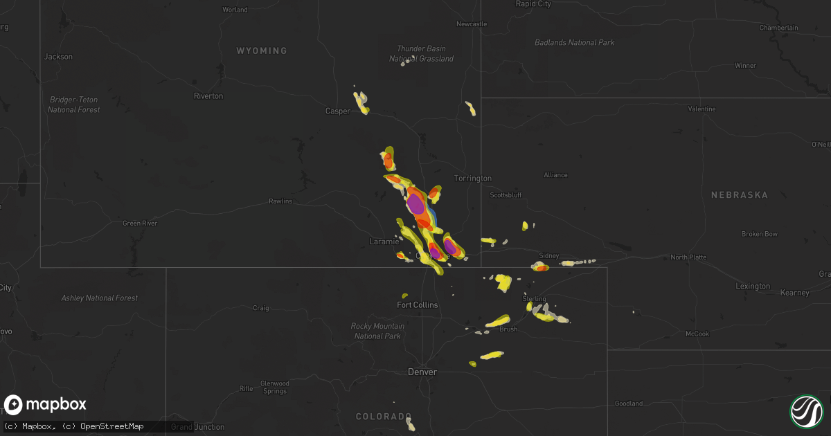
Hail Map on July 21, 2020
Get this storm
July 21 map
$229
one time, instant access
Download today. No call, no setup
Keep the $229
Bought the map and want the full workflow? Apply the entire $229 to a subscription within 7 days. None of it is wasted.
Every map, not just this one
This buys you this map. Subscription and you get every map we run, in the markets you choose from a few cities to whole states to nationwide. Plus real-time alerts the moment a storm fires.
Contact data
Name, contact info, occupancy, even credit band for addresses in the footprint. You go from where it hit to who to call.
Become the source they trust
Unlimited branding weather history reports on demand. You already have the documented answer ready for the property owner, and you are the one who showed up with it.
Property data and RoofTrace estimates
Pull up any address you have got, its value and the exact code rules for that jurisdiction, straight from One Click Code. Then RoofTrace estimates the squares, pitch, and roof value, priced the way you price.
States Impacted by Hail Map on July 21, 2020
Storm reports
Minnesota
| Date | Description |
|---|---|
| 07/21/20205:51 PM CDT | Report of a barn with a tin roof taken off. Passed along that other barns in the area were possibly damaged. |
| 07/20/202011:16 PM CDT | At 415 PM CDT, a severe thunderstorm was located 9 miles west of Danbury, or 18 miles east of Hinckley, moving southeast at 25 mph. HAZARD...60 mph wind gusts and quarter size hail. SOURCE...Radar indicated. IMPACT...Hail damage to vehicles is expected. Expect wind damage to roofs, siding, and trees. Locations impacted include... Webster, Hertel, Oakland, Big Sand Lake, Saint Croix State Park, and Yellow Lake. |
Texas
| Date | Description |
|---|---|
| 07/21/20204:55 PM CDT | A local report indicates 66 MPH wind near 4 E PALO DURO (JA) |
| 07/21/20207:56 AM CDT | At 1256 PM CDT, a severe thunderstorm was located near Medicine Mound, moving southeast at 5 mph. HAZARD...60 mph wind gusts and quarter size hail. SOURCE...Radar indicated. IMPACT...Hail damage to vehicles is expected. Expect wind damage to roofs, siding, and trees. Locations impacted include... Chillicothe and Medicine Mound. |
| 07/21/20201:32 AM CDT | At 632 PM CDT, a severe thunderstorm was located over Lubbock International Airport, or 10 miles northeast of Lubbock, moving southwest at 5 mph. HAZARD...70 mph wind gusts. SOURCE...Radar indicated. IMPACT...Expect considerable tree damage. Damage is likely to mobile homes, roofs, and outbuildings. Locations impacted include... Lubbock, Idalou, Lubbock International Airport, Texas Tech University, Downtown Lubbock and New Deal. |
| 07/20/202011:30 PM CDT | At 430 PM CDT, a severe thunderstorm was located 12 miles southwest of Clarendon, moving south at 10 mph. HAZARD...60 mph wind gusts and penny size hail. SOURCE...Radar indicated. IMPACT...Minor damage to roofs, siding, and trees is possible. Locations impacted include... Clarendon and Goodnight. |
| 07/20/202011:14 PM CDT | At 413 PM MDT, a severe thunderstorm was located over Canutillo, moving south at 10 mph. HAZARD...60 mph wind gusts and nickel size hail. SOURCE...Radar indicated. IMPACT...Expect damage to roofs, siding, and trees. Locations impacted include... West El Paso, Santa Teresa, Anthony, Sunland Park, Canutillo, Westway, Vinton and La Union.This includes Interstate 10 in Texas between mile markers 1 and 14. |
North Carolina
| Date | Description |
|---|---|
| 07/21/20206:45 PM CDT | 911 call center reported power lines down on elmhurst rd. |
| 07/21/20206:45 PM CDT | 911 call center reported power lines down on sewickley dr. |
| 07/21/20206:40 PM CDT | 911 call center reported power lines down on kenilworth ave. |
| 07/21/20206:40 PM CDT | 911 call center reported power lines down on mill haven lane. |
| 07/21/20206:40 PM CDT | 911 call center reported trees down on patton ave. |
| 07/21/20206:40 PM CDT | 911 call center reported power lines down on south blvd |
| 07/21/20206:40 PM CDT | 911 call center reported power lines down on university dr. |
| 07/21/20206:30 PM CDT | 911 call center reported trees down on ardmore rd. |
| 07/21/20206:30 PM CDT | 911 call center reported power lines down on w hampton ave. |
| 07/21/20206:30 PM CDT | 911 call center reported trees down on hollis rd. |
| 07/21/20206:25 PM CDT | A local report indicates 1.00 inch wind near 5 NW PINEVILLE |
| 07/21/20206:20 PM CDT | 911 call center reported power lines down on tuckaseegee rd. |
| 07/21/20206:15 PM CDT | 911 call center reported trees down on forbes rd. |
| 07/21/20206:10 PM CDT | 911 call center reported trees down on belwood dr. |
| 07/21/20206:00 PM CDT | Fire dept/rescue reported trees down on bandys cross rd. |
| 07/21/20205:30 PM CDT | 911 call center reported trees and power lines down on triplett rd. |
| 07/21/20205:10 PM CDT | 911 call center reported power lines down on mt pleasant rd n. |
| 07/21/20205:05 PM CDT | Strong winds and heavy rain also reported. |
| 07/21/20205:00 PM CDT | 911 call center reported power lines down on wickersham rd |
| 07/21/20205:00 PM CDT | 911 call center reported power lines down on commonwealth ave. |
| 07/21/20204:30 PM CDT | 911 call center reported trees and power lines down on triplett rd. |
| 07/21/20204:15 PM CDT | 911 call center reported trees down on w sugar creek rd. |
| 07/21/20204:13 PM CDT | Several trees snapped at their trunks. Time estimated from radar. |
| 07/21/20204:10 PM CDT | Emergency mngr reported thunderstorm wind damage to mobile home on lee bess rd |
| 07/21/20204:00 PM CDT | 911 call center reported trees and power lines down in ellenboro |
| 07/21/20204:00 PM CDT | Trained spotter reported trees down along nc-18 & us-64 in chesterfield nc us |
| 07/21/20204:00 PM CDT | 911 call center reported trees and power lines down in cliffside |
| 07/21/20202:00 PM CDT | 911 call center reported trees and power lines down near hendersonville and flat rock |
| 07/21/20201:15 PM CDT | 911 call center reported trees and power lines down on edgewater rd |
| 07/21/20204:27 AM CDT | At 926 PM EDT, a thunderstorms were intensifying along the Virginia, North Carolina Border, moving northeast at 20 mph. HAZARD...60 mph wind gusts and quarter size hail. SOURCE...Radar indicated. IMPACT...Hail damage to vehicles is expected. Expect wind damage to roofs, siding, and trees. Locations impacted include... Danville... Martinsville... Chatham... Blairs... Callands... Axton... and Ridgeway. |
| 07/21/20203:28 AM CDT | At 828 PM EDT, a severe thunderstorm was located over Mayodan, moving east at 15 mph. HAZARD...60 mph wind gusts and quarter size hail. SOURCE...Radar indicated. IMPACT...Hail damage to vehicles is expected. Expect wind damage to roofs, siding, and trees. Locations impacted include... Eden... Wentworth... Mayodan... Madison... Stoneville... Mayfield... and Oregon Hill. |
| 07/21/20201:03 AM CDT | At 603 PM EDT, a severe thunderstorm was located 11 miles west of Huntersville, or near Stanley, moving north at 10 mph. HAZARD...60 mph wind gusts and quarter size hail. SOURCE...Radar indicated. IMPACT...Minor hail damage to vehicles is expected. Expect wind damage to trees and power lines. Locations impacted include... Stanley, Westport, Denver, Lowesville, Lucia, Iron Station, Lake Norman, Cornelius, Northwest Charlotte and Huntersville. |
| 07/21/202012:56 AM CDT | At 556 PM EDT, a severe thunderstorm was located 5 miles west of Hickory, or near Hickory Regional Airport, and is nearly stationary. HAZARD...60 mph wind gusts and quarter size hail. SOURCE...Radar indicated. IMPACT...Minor hail damage to vehicles is expected. Expect wind damage to trees and power lines. Locations impacted include... Hickory, St. Stephens, Longview, Sawmills, Granite Falls, Bethlehem, Hudson, Icard, Hildebran and Connelly Springs. |
| 07/21/202012:54 AM CDT | At 554 PM EDT, a severe thunderstorm was located 6 miles south of Downtown Concord, or near Harrisburg, moving southwest at 5 mph. HAZARD...60 mph wind gusts and quarter size hail. SOURCE...Radar indicated. IMPACT...Minor hail damage to vehicles is expected. Expect wind damage to trees and power lines. Locations impacted include... Downtown Concord, West Concord, Harrisburg, Mt Pleasant, Charlotte Motor Speedway and Kannapolis. |
| 07/21/202012:42 AM CDT | At 542 PM EDT, a severe thunderstorm was located 5 miles south of Uptown Charlotte, or over Southpark Mall, moving north at 10 mph. HAZARD...60 mph wind gusts and penny size hail. SOURCE...Radar indicated. IMPACT...Expect damage to trees and power lines. Locations impacted include... Uptown Charlotte, Central Charlotte, South Charlotte, East Charlotte, Pineville, Freedom Park, The Plaza, The Arboretum, Southpark Mall and Matthews. |
| 07/21/202012:23 AM CDT | At 523 PM EDT, a severe thunderstorm was located 9 miles northwest of Kannapolis, or near Mooresville, moving northeast at 10 mph. HAZARD...60 mph wind gusts and penny size hail. SOURCE...Radar indicated. IMPACT...Expect damage to trees and power lines. Locations impacted include... Mooresville, China Grove, Landis, Enochville, Mount Ulla, Piedmont Research Station, Granite Quarry, Cleveland and Kannapolis. |
| 07/20/202011:56 PM CDT | At 456 PM EDT, a severe thunderstorm was located near Morganton, or near Drexel, moving east at 15 mph. HAZARD...60 mph wind gusts and quarter size hail. SOURCE...Radar indicated. IMPACT...Minor hail damage to vehicles is expected. Expect wind damage to trees and power lines. Locations impacted include... Lenoir, Morganton, Valdese, Gamewell, Cajah's Mountain, Drexel, Rutherford College, Glen Alpine, Lake Rhodhiss and Table Rock. |
| 07/20/202011:40 PM CDT | At 440 PM EDT, severe thunderstorms were located along a line extending from 3 miles east of Forest City to 12 miles southeast of Rutherfordton, moving east at 5 mph. HAZARD...60 mph wind gusts and quarter size hail. SOURCE...Radar indicated. IMPACT...Minor hail damage to vehicles is expected. Expect wind damage to trees and power lines. Locations impacted include... Forest City, Spindale, Boiling Springs NC, Mayo, Chesnee, Polkville, Ellenboro, Lattimore, Mooresboro and Bostic. |
| 07/20/202011:09 PM CDT | At 408 PM EDT, a severe thunderstorm was located 13 miles southeast of Newland, or 5 miles north of Table Rock, moving east at 10 mph. HAZARD...60 mph wind gusts and quarter size hail. SOURCE...Radar indicated. IMPACT...Minor hail damage to vehicles is expected. Expect wind damage to trees and power lines. Locations impacted include... Crossnore, Table Rock, Linville Falls, B.R. Parkway-Linville Falls To Grandfather, Edgemont, Ingalls, Altamont, Pineola, Collettsville and Ashford. |
| 07/20/202010:44 PM CDT | At 344 PM EDT, a severe thunderstorm was located near Spruce Pine, moving east at 10 mph. HAZARD...60 mph wind gusts and penny size hail. SOURCE...Radar indicated. IMPACT...Expect damage to trees and power lines. Locations impacted include... Spruce Pine, Linville Falls, North Cove, Micaville, Celo, Ashford, Little Switzerland, Woodlawn, Ingalls and B.R. Parkway-Little Switzerland To Linville. |
| 07/20/20209:59 PM CDT | At 259 PM EDT, a severe thunderstorm was located 11 miles northeast of Hendersonville, or near Bat Cave, moving east at 5 mph. HAZARD...60 mph wind gusts and quarter size hail. SOURCE...Radar indicated. IMPACT...Minor hail damage to vehicles is expected. Expect wind damage to trees and power lines. Locations impacted include... Lake Lure, Chimney Rock Village, Chimney Rock State Park, Bat Cave, Dana, Gerton, Edneyville and Lake Adger. |
| 07/20/20209:34 PM CDT | At 234 PM EDT, a severe thunderstorm was located 6 miles south of Waynesville, or near B.R. Parkway-Balsam Gap To Black Balsam Area, moving east at 5 mph. HAZARD...60 mph wind gusts and penny size hail. SOURCE...Radar indicated. IMPACT...Expect damage to trees and power lines. Locations impacted include... Cullowhee, Balsam, Webster, B.R. Parkway-Black Balsam To Mount Pisgah, B.R. Parkway-Balsam Gap To Black Balsam Area, Tuckasegee, Sunburst, Black Balsam Area, Waynesville and B.R. Parkway-Smoky Mountains To Balsam Gap. |
| 07/20/20208:52 PM CDT | At 152 PM EDT, a severe thunderstorm was located 9 miles northeast of Waynesville, or near Clyde, and is nearly stationary. HAZARD...60 mph wind gusts and quarter size hail. SOURCE...Radar indicated. IMPACT...Minor hail damage to vehicles is expected. Expect wind damage to trees and power lines. Locations impacted include... Waynesville, Canton, Lake Junaluska, Clyde, Maggie Valley, Leicester, Black Balsam Area, Cove Creek, Sunburst and Cruso. |
| 07/20/20208:43 PM CDT | At 142 PM EDT, a severe thunderstorm was located 4 miles northwest of Sylva, or near Dillsboro, and is nearly stationary. HAZARD...60 mph wind gusts and quarter size hail. SOURCE...Radar indicated. IMPACT...Minor hail damage to vehicles is expected. Expect wind damage to trees and power lines. Locations impacted include... Sylva, Cullowhee, Webster, Dillsboro, Savannah, Cherokee, Whittier and B.R. Parkway-Smoky Mountains To Balsam Gap. |
| 07/20/20207:34 PM CDT | Thunderstorm winds blew down a couple of trees near the intersection of mayo mountain road and business highway 220. |
Indiana
| Date | Description |
|---|---|
| 07/21/20206:45 PM CDT | Several trees up to 4 inches in diameter were blown down across the roadway. Location is approximate. |
| 07/21/20203:20 PM CDT | Tree limbs down on black cemetery rd between 800n and in-67. Time estd from radar. |
| 07/21/20202:45 PM CDT | A tree blocked the road and took power lines down. |
| 07/21/20202:45 PM CDT | Spotter relayed report of a tree fallen on power lines. |
| 07/21/20202:30 PM CDT | Spotter relayed report of power lines down. |
| 07/21/20202:20 PM CDT | Tree on house. Also multiple trees and limbs down across wabash. |
| 07/21/20202:15 PM CDT | Utility poles down at w. Main st. And fremont st. |
| 07/21/20201:53 PM CDT | Numerous portions of trees and branches down. Utility pole down. |
| 07/21/20201:51 PM CDT | Corrects previous tstm wnd gst report from 1 s grissom afb. Corrects previous tstm wnd gst report from 1 s grissom afb. |
| 07/21/20201:12 PM CDT | Multiple trees down with power outages reported. |
| 07/21/20201:11 PM CDT | Large metal doors were blown off of the toyota tsusho america inc plant at 5440 haggerty lane. Employee told tv media that if not for the tornado warning and their resu |
| 07/21/20201:06 PM CDT | Multiple tree limbs down. Location approximate. |
| 07/21/202012:55 PM CDT | Trees down in middle of greenhill. Time est from radar. |
| 07/21/202012:40 PM CDT | Trees down at both 100 pine st and on brady st. Time est from radar. |
| 07/21/202012:33 PM CDT | Tree down in oxford along state road 352 near state road 55. Time estimated by radar. |
| 07/21/202012:30 PM CDT | Tree down at 700w and galloway chapel rd. Time estd from radar. |
| 07/21/20206:29 AM CDT | At 1128 AM CDT, a severe thunderstorm was located over Thomasboro, or near Rantoul, moving east at 40 mph. HAZARD...60 mph wind gusts. SOURCE...Radar indicated. IMPACT...Expect damage to roofs, siding, and trees. Locations impacted include... Champaign, Rantoul, Urbana, Hoopeston, Rossville, Thomasboro, Gifford, Potomac, Rankin, Bismarck, Ludlow, Royal, Henning, Collison, Dewey, Flatville, Middle Fork Wildlife Area, Armstrong, Alvin and Penfield.This includes the following highways... Interstate 57 between mile markers 237 and 257. Interstate 74 between mile markers 179 and 185. |
| 07/21/20204:14 AM CDT | At 914 PM EDT, severe thunderstorms were located along a line extending from 14 miles south of Crawfordsville to 10 miles south of Greencastle, moving east at 35 mph. HAZARD...60 mph wind gusts. SOURCE...Radar indicated. IMPACT...Expect damage to roofs, siding, and trees. Locations impacted include... Plainfield, Brownsburg, Greencastle, Mooresville, Danville, Avon, Pittsboro, Cloverdale, Brooklyn, Monrovia, Ladoga, Clayton, Roachdale, Bainbridge, Fillmore, Coatesville, North Salem, Lizton, Amo and Stilesville.This includes the following highways... Interstate 70 between mile markers 34 and 68. Interstate 74 between mile markers 55 and 69. |
| 07/21/20203:44 AM CDT | At 844 PM EDT, severe thunderstorms were located along a line extending from near Rockville to near Brazil, moving east at 20 mph. HAZARD...60 mph wind gusts. SOURCE...Radar indicated. IMPACT...Expect damage to roofs, siding, and trees. Locations impacted include... Greencastle, Brazil, Knightsville, Harmony, Carbon, Russellville, Marshall, Bridgeton, Reelsville, Lena, Cecil Harden Lake and Judson.This includes Interstate 70 between mile markers 30 and 36. |
| 07/21/20203:01 AM CDT | At 801 PM EDT, severe thunderstorms were located along a line extending from near Georgetown to near Vermilion to Oliver, moving east at 30 mph. HAZARD...60 mph wind gusts and penny size hail. SOURCE...Radar indicated. IMPACT...Expect damage to roofs, siding, and trees. Locations impacted include... Terre Haute, Brazil, Clinton, Rockville, West Terre Haute, Fairview Park, Seelyville, Montezuma, Knightsville, Rosedale, Harmony, Staunton, Carbon, Universal, Mecca, Fontanet, Blanford, Shepardsville, Lena and Cecil Harden Lake.This includes Interstate 70 between mile markers 3 and 5, and betweenmile markers 11 and 29. |
| 07/21/20202:32 AM CDT | At 732 PM EDT, a severe thunderstorm was located 7 miles north of Bloomington, moving east at 10 mph. HAZARD...60 mph wind gusts and half dollar size hail. SOURCE...Radar indicated. IMPACT...Hail damage to vehicles is expected. Expect wind damage to roofs, siding, and trees. Locations impacted include... Lake Lemon, Mahalasville and Helmsburg. |
| 07/21/20202:14 AM CDT | At 714 PM CDT, a severe thunderstorm was located near West Union, or 10 miles southwest of Marshall, moving east at 35 mph. HAZARD...60 mph wind gusts. SOURCE...Radar indicated. IMPACT...Expect damage to roofs, siding, and trees. Locations impacted include... Marshall, Martinsville, Clarksville, Dennison, Annapolis, West Union, Oliver, York, Darwin, Orange, West York and Lincoln Trail State Park.This includes Interstate 70 between mile markers 134 and 154. |
| 07/21/20201:37 AM CDT | At 636 PM CDT, a severe thunderstorm was located near Redmon, or near Paris, moving east at 40 mph. HAZARD...60 mph wind gusts. SOURCE...Radar indicated. IMPACT...Expect damage to roofs, siding, and trees. Locations impacted include... Paris, Chrisman, Kansas, Hume, Vermilion, Redmon, Oliver, Edgar, Metcalf, Bell Ridge, Scottland and Edgar County Airport. |
| 07/21/20201:01 AM CDT | At 600 PM EDT, a severe thunderstorm was located 8 miles southwest of Osgood, and is nearly stationary. HAZARD...60 mph wind gusts and penny size hail. SOURCE...Radar indicated. IMPACT...Expect damage to trees and power lines. Locations impacted include... Versailles, Osgood, Holton, Versailles Lake, Rexville, Otter Village, Benham and New Marion. |
| 07/20/202011:55 PM CDT | At 454 PM EDT, a severe thunderstorm was located over Union City, moving east at 45 mph. HAZARD...60 mph wind gusts. SOURCE...Radar indicated. IMPACT...Expect damage to trees and power lines. Locations impacted include... Sidney, Piqua, Greenville, Versailles, Covington, Newport, Bradford, Union City, Ansonia, Hardin, Webster, Russia, Gettysburg, Fletcher, Port Jefferson, Rossburg, Lockington, Yorkshire, Polo and Newbern.This includes I-75 in Ohio between mile markers 78 and 95. |
| 07/20/202011:09 PM CDT | At 409 PM EDT, a severe thunderstorm was located near Muncie, moving east at 45 mph. HAZARD...60 mph wind gusts. SOURCE...Radar indicated. IMPACT...Expect damage to roofs, siding, and trees. Locations impacted include... Muncie, Yorktown, Albany, Eaton, Daleville, Gaston, Selma and Ball State University.This includes Interstate 69 between mile markers 234 and 246. |
| 07/20/20209:38 PM CDT | At 238 PM EDT, severe thunderstorms were located along a line extending from near Walton to 6 miles southeast of Frankfort, moving east at 40 mph. HAZARD...60 mph wind gusts. SOURCE...Radar indicated. IMPACT...Expect damage to roofs, siding, and trees. Locations impacted include... Kokomo, Frankfort, Russiaville, Kirklin, Sharpsville, Burlington, Michigantown, Kempton and Indian Heights.This includes Interstate 65 between mile markers 151 and 152. |
| 07/20/20208:44 PM CDT | At 143 PM EDT, a severe thunderstorm was located 7 miles east of Williamsport, or 12 miles south of Otterbein, moving east at 45 mph. HAZARD...60 mph wind gusts. SOURCE...Radar indicated. IMPACT...Expect damage to roofs, siding, and trees. Locations impacted include... Lafayette, West Lafayette, Attica, Shadeland, Dayton, Battle Ground, Clarks Hill, Newtown, Pine Village and Purdue University.This includes Interstate 65 between mile markers 161 and 183. |
| 07/20/20208:20 PM CDT | Sporadic power lines down across town. A measured 50 mph gust was made near this location. Time estimated from radar. |
| 07/20/20208:09 PM CDT | At 108 PM EDT, a severe thunderstorm was located near Rossville, or 12 miles north of Danville Illinois, moving east at 45 mph. HAZARD...60 mph wind gusts. SOURCE...Radar indicated. IMPACT...Expect damage to roofs, siding, and trees. Locations impacted include... Williamsport, Attica, West Lebanon, Newtown, Pine Village, State Line City, Tab, Rainsville and Pence. |
| 07/20/20207:59 PM CDT | Trees were blown down. |
| 07/20/20207:46 PM CDT | Tree blown down. |
| 07/20/20207:46 PM CDT | Corrects previous tstm wnd dmg report from cloverdale. A tree was blown down. |
| 07/20/20207:45 PM CDT | Several trees were blown down in this vicinity. |
Mississippi
| Date | Description |
|---|---|
| 07/21/20203:35 PM CDT | Large tree down on home and roof damage to outbuildings near the intersection of highways 9 and 334. An additional 15-20 trees down nearby. |
| 07/20/202011:48 PM CDT | At 448 PM CDT, a severe thunderstorm was located 7 miles southeast of Red Bay, moving northwest at 10 mph. HAZARD...60 mph wind gusts and quarter size hail. SOURCE...Radar indicated. IMPACT...Hail damage to vehicles is expected. Expect wind damage to roofs, siding, and trees. Locations impacted include... Red Bay, Vina, Atwood, Dempsey, Little Bear Creek Reservoir and Halltown. |
| 07/20/202010:10 PM CDT | At 309 PM CDT, severe thunderstorms were located along a line extending from Gore Springs to near Duck Hill, moving north at 15 mph. HAZARD...60 mph wind gusts and quarter size hail. SOURCE...Radar indicated. IMPACT...Hail damage to vehicles is expected. Expect wind damage to roofs, siding, and trees. Severe thunderstorms will be near... Gore Springs around 320 PM CDT. Elliott around 330 PM CDT. Grenada around 415 PM CDT. |
Georgia
| Date | Description |
|---|---|
| 07/21/20206:00 PM CDT | Multiple trees down. Some shingles halfway peeled on roof. |
| 07/21/20203:45 PM CDT | Large tree blown down in northern marietta reported by local media |
| 07/21/20203:30 PM CDT | A couple trees were reported down in the vacinity of writes mill rd and carlan rd in southeastern banks county |
| 07/21/20203:20 PM CDT | A local report indicates 1.50 inch wind near 5 S DAWNVILLE |
| 07/21/20203:20 PM CDT | A couple trees reported down south of commerce. |
| 07/21/20203:15 PM CDT | 4 total trees down. 1 large oak down on house. |
| 07/21/20203:02 PM CDT | Several small trees down north of sandy springs... Blocking the roadway near spalding dr and preachtree dunwoody rd |
| 07/21/20202:58 PM CDT | At least 15 trees were downed in sharpsburg in the 200 block of marion beavers road and a few surrounding areas. |
| 07/21/20202:58 PM CDT | Tree down off hwy 441 near old athens dr |
| 07/21/20202:40 PM CDT | Reports of multiple trees down in the area around winder... Including one down on a home on hickeria way... Ne of town. |
| 07/21/20202:25 PM CDT | 3 trees were reported down on blackmon farm road near pecan grove road. |
| 07/21/20202:15 PM CDT | Minor roof damage caused by strong winds to a home on livingston ct near winder |
| 07/21/202012:25 PM CDT | Public reported one tree down on clayton road and another down on marie drive. |
| 07/21/202011:56 AM CDT | Public reported golf ball size hail fell for 3 to 4 mintues near lake trahlyta. |
| 07/21/202011:55 AM CDT | Public reported quarter size hail at a location on allison circle... Lasting 3-5 minutes. Hail caused damage to camper ac unit. |
| 07/21/202011:55 AM CDT | Public reported quarter size hail at a location on allison circle... Lasting 3-5 minutes. Hail caused damage to camper ac unit. |
| 07/21/202011:48 AM CDT | Public reported accumulating 1.50 inch hail at a location off sullivan trail road... Lasting more than five minutes. |
| 07/21/20207:52 AM CDT | At 1251 PM EDT, a severe thunderstorm was located over Vogel State Park, or 7 miles south of Blairsville, and is nearly stationary. HAZARD...60 mph wind gusts and quarter size hail. SOURCE...Radar indicated. IMPACT...Hail damage to vehicles is expected. Expect wind damage to roofs, siding, and trees. Locations impacted include... Owltown, Woods Hole Shelter, Blood Mountain Shelter, Vogel State Park, Brasstown Bald and Track Rock. |
| 07/20/202011:53 PM CDT | At 453 PM CDT, a severe thunderstorm was located near Moshat, or 7 miles west of Forney, and is nearly stationary. HAZARD...60 mph wind gusts and nickel size hail. SOURCE...Radar indicated. IMPACT...Expect damage to roofs, siding, and trees. Locations impacted include... Centre, Forney, Pleasant Gap, Tennala, Moshat, Ball Flat, Western Weiss Lake, Eastern Weiss Lake and Coloma. |
| 07/20/202011:19 PM CDT | At 419 PM EDT, a severe thunderstorm was located near Pulaski State Prison, or near Hawkinsville, moving southwest at 10 mph. HAZARD...60 mph wind gusts and quarter size hail. SOURCE...Radar indicated. IMPACT...Hail damage to vehicles is expected. Expect wind damage to roofs, siding, and trees. Locations impacted include... Hawkinsville, Browndale, Wallace, Tippettville, Mock Springs, Klondike and Finleyson. |
| 07/20/202011:18 PM CDT | At 418 PM EDT, a severe thunderstorm was located over Commerce, and is nearly stationary. HAZARD...60 mph wind gusts and quarter size hail. SOURCE...Radar indicated. IMPACT...Hail damage to vehicles is expected. Expect wind damage to roofs, siding, and trees. Locations impacted include... Jefferson, Commerce, Maysville, Arcade, Nicholson, Ila, Pocataligo, Peach State Speedway, Apple Valley and Banks Crossing. |
| 07/20/202011:10 PM CDT | At 410 PM EDT, a severe thunderstorm was located over Hapeville, or 7 miles south of Atlanta, and is nearly stationary. HAZARD...60 mph wind gusts and quarter size hail. SOURCE...Radar indicated. IMPACT...Hail damage to vehicles is expected. Expect wind damage to roofs, siding, and trees. Locations impacted include... Atlanta, East Point, Forest Park, Riverdale, College Park, Hapeville, Hartsfield-Jackson Airport, Cascade Heights, Lakewood Park and Conley. |
| 07/20/202011:08 PM CDT | At 407 PM EDT, a severe thunderstorm was located over North Georgia Speedway, or near Chatsworth, moving southwest at 20 mph. HAZARD...60 mph wind gusts and half dollar size hail. SOURCE...Radar indicated. IMPACT...Hail damage to vehicles is expected. Expect wind damage to roofs, siding, and trees. Locations impacted include... Dalton, Chatsworth, Eton, Crandall, Beaverdale, Dawnville, Sumac, Tilton and North Georgia Speedway. |
| 07/20/202010:17 PM CDT | At 317 PM EDT, a severe thunderstorm was located near Celeste, or near Washington, and is nearly stationary. HAZARD...60 mph wind gusts and half dollar size hail. SOURCE...Radar indicated. IMPACT...Hail damage to vehicles is expected. Expect wind damage to roofs, siding, and trees. Locations impacted include... Washington, Tignall, Rayle, Jacksons Crossroads, Mallorysville, Newtown, Delhi, Norman, Danburg, Celeste and Floral Hill. |
Nebraska
| Date | Description |
|---|---|
| 07/21/20203:12 AM CDT | At 812 PM MDT, a severe thunderstorm was located near Redington, or 25 miles northeast of Kimball, moving southeast at 15 mph. HAZARD...60 mph wind gusts and quarter size hail. SOURCE...Radar indicated. IMPACT...Hail damage to vehicles is expected. Expect wind damage to roofs, siding, and trees. Locations impacted include... Court House And Jail Rocks and Redington. |
| 07/20/20208:49 PM CDT | Two empty and un-anchored 10x14 outbuildings... Located north of the double l cafe... On hwy 71 4 miles se of harrisburg... Ne... Were flipped upside down by wind... Es |
Louisiana
| Date | Description |
|---|---|
| 07/20/20209:28 PM CDT | At 228 PM CDT, a severe thunderstorm was located over Erwinville, or 10 miles northwest of Port Allen, moving northwest at 15 mph. HAZARD...60 mph wind gusts and penny size hail. SOURCE...Radar indicated. IMPACT...Expect damage to roofs, siding, and trees. Locations impacted include... New Roads, Livonia, Fordoche and Erwinville. |
Ohio
| Date | Description |
|---|---|
| 07/21/20204:30 PM CDT | Gutters torn down from wind. Time estimated. |
| 07/21/20203:38 PM CDT | A tree was downed in the 700 block of murlin avenue. |
| 07/21/20204:14 AM CDT | At 913 PM EDT, severe thunderstorms were located along a line extending from New Concord to 9 miles north of McConnelsville, moving east at 25 mph. HAZARD...Wind gusts to 60 mph. SOURCE...Radar. IMPACT...Expect damage to trees and power lines, resulting in some power outages. Locations impacted include... Cambridge... Caldwell... New Concord... Byesville... Dudley... Quaker City... Senecaville... Pleasant City... Cumberland... Lore City... Belle Valley... Sarahsville...This includes the following highways... Interstate 70 in Ohio between mile markers 166 and 184. Interstate 77 in Ohio between mile markers 20 and 46. |
Kentucky
| Date | Description |
|---|---|
| 07/21/20206:30 PM CDT | Social media report of one tree down across newman way near nashville road. |
| 07/21/20206:17 PM CDT | Small area of corn blown down...most of field not affected. |
| 07/21/20205:11 PM CDT | Tree down. |
| 07/21/20206:05 AM CDT | At 1105 PM EDT, a severe thunderstorm was located over Jarvis, or near Barbourville, moving northeast at 30 mph. HAZARD...60 mph wind gusts. SOURCE...Radar indicated. IMPACT...Expect damage to roofs, siding, and trees. Locations impacted include... Barbourville, Manchester, Brightshade, Lake, Cane Creek, Treadway, Goose Rock, Jarvis, Bush, Cranes Nest, Girdler and Jonsee. |
| 07/21/20205:27 AM CDT | At 1027 PM EDT, a severe thunderstorm was located over Rockholds, or near Williamsburg, moving northeast at 10 mph. HAZARD...60 mph wind gusts. SOURCE...Radar indicated. IMPACT...Expect damage to roofs, siding, and trees. Locations impacted include... Williamsburg, Barbourville, Julip, Cannon, Garrich, Emmanuel, Swan Lake, Moore Hill, Clate, Clio, Rossland and Verne. |
| 07/21/202012:54 AM CDT | At 554 PM CDT, a severe thunderstorm was located 8 miles northeast of Russellville, moving northeast at 15 mph. HAZARD...60 mph wind gusts. SOURCE...Radar indicated. IMPACT...Expect damage to roofs, siding, and trees. Locations impacted include... Anderson, Gasper, Insco, Davis Crossroads, Homer, Buffalo Fork, Chandlers Chapel, Costelow, and Richelieu. |
| 07/20/202011:58 PM CDT | At 458 PM CDT, a severe thunderstorm was located 8 miles northwest of Cross Plains, or 10 miles northeast of Springfield, moving north at 5 mph. HAZARD...60 mph wind gusts. SOURCE...Radar indicated. IMPACT...Expect damage to roofs, siding, and trees. Locations impacted include... Cross Plains and Orlinda. |
| 07/20/202010:05 PM CDT | Tree down near highway 1803. Time estimated from radar. |
Missouri
| Date | Description |
|---|---|
| 07/21/20206:27 PM CDT | Time estimated from radar. |
| 07/21/20205:50 PM CDT | Large tree limb snapped from tree. |
| 07/21/20202:20 PM CDT | At i-370 and elm street. |
| 07/21/20202:10 PM CDT | Two large tree limbs blown down at oregon trail and woodstream. Via facebook. |
| 07/21/20203:53 AM CDT | At 853 PM CDT, a severe thunderstorm was located 10 miles west of Potosi, moving east at 25 mph. HAZARD...60 mph wind gusts and quarter size hail. SOURCE...Radar indicated. IMPACT...Hail damage to vehicles is expected. Expect wind damage to roofs, siding, and trees. Locations impacted include... Potosi, Irondale, Mineral Point, Old Mines, Latty, Cadet and Shirley.This also includes Washington State Park. |
| 07/21/20201:18 AM CDT | At 618 PM CDT, a severe thunderstorm was located near Hillsboro, moving northeast at 10 mph. HAZARD...60 mph wind gusts and quarter size hail. SOURCE...Radar indicated. IMPACT...Hail damage to vehicles is expected. Expect wind damage to roofs, siding, and trees. Locations impacted include... Pevely, Hillsboro, Byrnes Mill, Barnhart, Antonia, Cedar Hill, Cedar Hill Lakes, House Springs, Scotsdale, Otto, Mapaville and Morse Mill.This also includes Sandy Creek Covered Bridge Historic Site. |
| 07/20/202011:40 PM CDT | Multiple trees down in park hills and elvins... Including some over power lines. Lots of tree debris on west elvins boulevard. Time estimated from radar. |
| 07/20/202011:20 PM CDT | At 420 PM CDT, a severe thunderstorm was located over Treloar, moving northeast at 25 mph. HAZARD...60 mph wind gusts and quarter size hail. SOURCE...Radar indicated. IMPACT...Hail damage to vehicles is expected. Expect wind damage to roofs, siding, and trees. Locations impacted include... Wentzville, Lake St. Louis, Washington, New Haven, Marthasville, Innsbrook, New Melle, Treloar, Dutzow, Defiance, Flint Hill, Foristell, Matson and Holstein.This includes Interstate 70 in Missouri between exits 203 and 210. |
| 07/20/202011:17 PM CDT | At 416 PM CDT, a severe thunderstorm was located near Sedalia, moving northeast at 40 mph. HAZARD...60 mph wind gusts and penny size hail. SOURCE...Radar indicated. IMPACT...Expect damage to roofs, siding, and trees. Locations impacted include... Sedalia, Smithton and Sedalia Memorial Arpt. |
| 07/20/20209:57 PM CDT | At 257 PM CDT, a severe thunderstorm was located near Portage Des Sioux, moving northeast at 20 mph. HAZARD...60 mph wind gusts and quarter size hail. SOURCE...Radar indicated. IMPACT...Hail damage to vehicles is expected. Expect wind damage to roofs, siding, and trees. Locations impacted include... Alton, Edwardsville, Godfrey, Wood River, Bethalto, East Alton, Brighton, South Roxana, Roxana, Hartford, West Alton, Dorsey, Rosewood Heights and Fosterburg. |
| 07/20/20209:15 PM CDT | At 215 PM CDT, a severe thunderstorm was located near Leasburg, moving northeast at 30 mph. HAZARD...60 mph wind gusts and quarter size hail. SOURCE...Radar indicated. IMPACT...Hail damage to vehicles is expected. Expect wind damage to roofs, siding, and trees. Locations impacted include... Sullivan, St. Clair, Bourbon, Gerald, Leasburg, St. Cloud, Noser Mill, Japan, Stanton and Oak Hill.This includes Interstate 44 in Missouri between exits 210 and 230. |
| 07/20/20209:12 PM CDT | At 212 AM CDT, a severe thunderstorm was located over Pacific, moving east at 10 mph. HAZARD...60 mph wind gusts and nickel size hail. SOURCE...Radar indicated. IMPACT...Expect damage to roofs, siding, and trees. Locations impacted include... Chesterfield, Wildwood, Ballwin, Eureka, Ellisville, Pacific, Byrnes Mill, Clarkson Valley, Gray Summit, High Ridge, Cedar Hill, Villa Ridge, House Springs, Scotsdale, Parkdale, Otto, Robertsville and Catawissa.This includes Interstate 44 in Missouri between exits 251 and 269. This also includes Route 66 State Park, Castlewood State Park, andRobertsville State Park. |
Illinois
| Date | Description |
|---|---|
| 07/21/20205:54 PM CDT | Report of tree taking down power line on southside drive... Blocking road. |
| 07/21/20205:10 PM CDT | A local report indicates 65 MPH wind near LONG CREEK |
| 07/21/20205:00 PM CDT | Large tree down along county road 2400e. |
| 07/21/20204:45 PM CDT | Approx 4 inch tree limbs down into power lines in stonington. Winds est to 60 mph by emergency manager. |
| 07/21/20204:34 PM CDT | Approx 4 inch tree limbs down into power lines in edinburgh. Old power pole snapped on west side of town. Winds est to 60 mph by emergency manager. |
| 07/21/20204:27 PM CDT | Approx 4 inch tree limbs down into power lines in kincaid. Winds est to 60 mph by emergency manager. |
| 07/21/20204:25 PM CDT | Approx 4 inch tree limbs down into power lines in tovey. Winds est to 60 mph by emergency manager. |
| 07/21/20204:20 PM CDT | Numerous trees down. |
| 07/21/20204:20 PM CDT | Aprs mesonet |
| 07/21/20204:18 PM CDT | Power poles down. |
| 07/21/20204:18 PM CDT | Montgomery co. Emergency management reported a tornado on the ground near white oak. |
| 07/21/20204:08 PM CDT | Reports of debris and power outages. |
| 07/21/20204:08 PM CDT | Reports of debris and power outages. |
| 07/21/20204:08 PM CDT | Reports of debris and power outages. |
| 07/21/20204:08 PM CDT | Damage to grain bin and out building... 55 ft tall-12 in diameter tree down across road. |
| 07/21/20204:08 PM CDT | Damage to grain bin and out building... 55 ft tall-12 in diameter tree down across road. |
| 07/21/20204:07 PM CDT | A local report indicates 65 MPH wind near AUBURN |
| 07/21/20204:00 PM CDT | Trees downed. |
| 07/21/20203:48 PM CDT | Numerous trees down around town... Some blocking roads. Also... A couple of sheds were damaged. |
| 07/21/20203:32 PM CDT | A local report indicates 1.00 inch wind near PLEASANT PLAINS |
| 07/21/20203:27 PM CDT | Several trees down on powerlines in the city. Also... Pea to marble size hail reported. |
| 07/21/20203:20 PM CDT | A couple trees down on the west side of town. |
| 07/21/20203:15 PM CDT | 12in tree limb fell on homeowners deck... Damaging it. |
| 07/21/20203:13 PM CDT | Several trees blown down in town as well as some power outages. |
| 07/21/20202:36 PM CDT | Numerous trees blown down around town. One tree fell onto a house. |
| 07/21/20201:43 PM CDT | Numerous tree branches down... Leaning power poles... Power out in town. |
| 07/21/202011:35 AM CDT | A local report indicates 63 MPH wind near 1 ESE RANTOUL |
| 07/21/202011:34 AM CDT | Numerous tree branches down... Leaning power poles... Power out in town. |
| 07/21/202011:30 AM CDT | Multiple structures damaged |
| 07/21/202011:01 AM CDT | Multiple trees and tree branches down in town. One tree smashed the park pavilion. |
| 07/21/20205:48 AM CDT | At 1048 AM CDT, a severe thunderstorm was located near Weldon, or 11 miles northeast of Clinton, moving east at 40 mph. HAZARD...60 mph wind gusts. SOURCE...Radar indicated. IMPACT...Expect damage to roofs, siding, and trees. Locations impacted include... Mahomet, Farmer City, Fisher, Mansfield, Lake Of The Woods, Bellflower, De Witt, Foosland, Dewey and Galesville.This includes Interstate 74 between mile markers 152 and 178. |
| 07/21/202012:14 AM CDT | At 514 PM CDT, a severe thunderstorm was located near Long Creek, or near Decatur, moving northeast at 50 mph. HAZARD...60 mph wind gusts. SOURCE...Radar indicated. IMPACT...Expect damage to roofs, siding, and trees. Locations impacted include... Decatur, Monticello, Tuscola, Sullivan, Mount Zion, Forsyth, Arthur, Bement, Cerro Gordo, Bethany, Long Creek, Atwood, Lovington, Argenta, Oreana, Pesotum, Dalton City, Hammond, White Heath and Bourbon.This includes the following highways... Interstate 57 between mile markers 206 and 223. Interstate 72 between mile markers 142 and 169. |
| 07/20/202011:39 PM CDT | At 438 PM CDT, severe thunderstorms were located along a line extending from near Mechanicsburg to Taylorville, moving east at 45 mph. HAZARD...60 mph wind gusts. SOURCE...Radar indicated. IMPACT...Expect damage to roofs, siding, and trees. Locations impacted include... Decatur, Taylorville, Mount Zion, Forsyth, Moweaqua, Harristown, Long Creek, Blue Mound, Macon, Stonington, Illiopolis, Niantic, Mechanicsburg, Mount Auburn, Buffalo, Boody, Willeys, Elwin, Decatur Airport and Hervey City.This includes Interstate 72 between mile markers 114 and 143. |
| 07/20/202010:45 PM CDT | At 344 PM CDT, severe thunderstorms were located along a line extending from near Alexander to near Palmyra, moving northeast at 40 mph. HAZARD...60 mph wind gusts and quarter size hail. SOURCE...Radar indicated. IMPACT...Hail damage to vehicles is expected. Expect wind damage to roofs, siding, and trees. Locations impacted include... Springfield, Chatham, Alexander, Auburn, Sherman, Rochester, Riverton, Pawnee, Williamsville, New Berlin, Waverly, Divernon, Loami, Franklin, Jerome, Southern View, Leland Grove, Grandview, Spaulding and Thayer.This includes the following highways... Interstate 55 between mile markers 77 and 106. Interstate 72 between mile markers 73 and 109. |
| 07/20/202010:38 PM CDT | At 338 PM CDT, a severe thunderstorm was located near Dorsey, moving northeast at 15 mph. HAZARD...60 mph wind gusts and quarter size hail. SOURCE...Radar indicated. IMPACT...Hail damage to vehicles is expected. Expect wind damage to roofs, siding, and trees. Locations impacted include... Staunton, Mount Olive, Bunker Hill, Benld, Worden, Livingston, Wilsonville, Sawyerville, Mount Clare, Prairietown, Dorsey, White City, Williamson, Royal Lakes, Dorchester, Pruett and Fosterburg.This includes Interstate 55 in Illinois between exits 41 and 44. |
| 07/20/202010:20 PM CDT | At 320 PM CDT, a severe thunderstorm was located over Murphysboro, moving northeast at 30 mph. HAZARD...60 mph wind gusts and quarter size hail. SOURCE...Radar indicated. IMPACT...Hail damage to vehicles is expected. Expect wind damage to roofs, siding, and trees. Locations impacted include... Carbondale, Murphysboro, De Soto, Elkville, Hurst and Vergennes. |
| 07/20/202010:12 PM CDT | At 312 PM CDT, a severe thunderstorm was located over Pleasant Plains, or 15 miles southeast of Virginia, moving northeast at 30 mph. HAZARD...60 mph wind gusts and quarter size hail. SOURCE...Radar indicated. IMPACT...Hail damage to vehicles is expected. Expect wind damage to roofs, siding, and trees. Locations impacted include... Springfield, Sherman, Riverton, Athens, Williamsville, Pleasant Plains, Tallula, Spaulding, Berlin, Cantrall, Capital Airport, Salisbury, Farmingdale, Lincolns New Salem and Fancy Prairie.This includes the following highways... Interstate 55 between mile markers 100 and 107. Interstate 72 between mile markers 80 and 81. |
| 07/20/20209:51 PM CDT | At 251 PM CDT, a severe thunderstorm was located over Hardin, moving north at 25 mph. HAZARD...60 mph wind gusts and nickel size hail. SOURCE...Radar indicated. IMPACT...Expect damage to roofs, siding, and trees. Locations impacted include... White Hall, Carrollton, Roodhouse, Hardin, Patterson, Kampsville, Eldred, Hillview, Belltown, Berdan, Haypress, Barrow, Walkersville, Woody and Michael. |
| 07/20/20209:41 PM CDT | At 241 PM CDT, a severe thunderstorm was located near Pittsfield, moving east at 35 mph. HAZARD...60 mph wind gusts and quarter size hail. SOURCE...Radar indicated. IMPACT...Hail damage to vehicles is expected. Expect wind damage to roofs, siding, and trees. Locations impacted include... Jacksonville, Virginia, Winchester, Alexander, Ashland, Waverly, Bluffs, Franklin, Murrayville, Woodson, Chapin, Arenzville, Manchester, Alsey, Naples, Exeter, Literberry, South Jacksonville, Philadelphia and Concord.This includes Interstate 72 between mile markers 43 and 79. |
| 07/20/20209:28 PM CDT | At 228 PM CDT, a severe thunderstorm was located 8 miles west of Grafton, moving north at 25 mph. HAZARD...60 mph wind gusts and penny size hail. SOURCE...Radar indicated. IMPACT...Expect damage to roofs, siding, and trees. Locations impacted include... Hardin, Fieldon, Batchtown, Brussels, Meppen, Beechville and Nutwood.This also includes Pere Marquette State Park. |
| 07/20/20209:27 PM CDT | At 227 PM CDT, a severe thunderstorm was located over St. Charles, moving northeast at 20 mph. HAZARD...60 mph wind gusts and nickel size hail. SOURCE...Radar indicated. IMPACT...Expect damage to roofs, siding, and trees. Locations impacted include... St. Charles, St. Peters, Florissant, Alton, Maryland Heights, Hazelwood, Bridgeton, Berkeley, Black Jack, Spanish Lake, Lambert-St. Louis International Airport, East Alton, West Alton, Portage Des Sioux, Orchard Farms and Kampville.This includes Interstate 70 in Missouri between exits 227 and 231. This also includes Confluence State Park and First Missouri StateCapitol Historic Site. |
| 07/20/20209:12 PM CDT | At 211 PM CDT, severe thunderstorms were located along a line extending from near Barry to near Atlas to near Curryville, moving east at 30 mph. HAZARD...60 mph wind gusts and quarter size hail. SOURCE...Radar indicated. IMPACT...Hail damage to vehicles is expected. Expect wind damage to roofs, siding, and trees. Locations impacted include... Bowling Green, Pittsfield, Louisiana, Barry, Griggsville, Pleasant Hill, Atlas, Clarksville, Pike, Tarrants, Belleview, Independence, Bedford, Montezuma, Martinsburg, Perry, New Canton, Nebo, Milton and Baylis.This includes Interstate 72 between exits 20 and 35. |
| 07/20/20209:07 PM CDT | At 206 PM CDT, a severe thunderstorm was located over St. Peters, moving northeast at 25 mph. HAZARD...60 mph wind gusts and penny size hail. SOURCE...Radar indicated. IMPACT...Expect damage to roofs, siding, and trees. Locations impacted include... O'Fallon, St. Charles, St. Peters, Dardenne Prairie, Weldon Spring, Cottleville, Orchard Farms, Harvester, Brussels, Golden Eagle, Deer Plain and Kampville.This includes Interstate 70 in Missouri between exits 217 and 229. This also includes First Missouri State Capitol Historic Site. |
| 07/20/20208:36 PM CDT | At 135 PM CDT, severe thunderstorms were located along a line extending from New London to near Frankford to near Spencerburg, moving east at 25 mph. HAZARD...60 mph wind gusts and quarter size hail. SOURCE...Radar indicated. IMPACT...Hail damage to vehicles is expected. Expect wind damage to roofs, siding, and trees. Locations impacted include... Hannibal, Louisiana, Barry, New London, Atlas, Frankford, Pike, Curryville, Spencerburg, Tarrants, Hull, New Canton, Kinderhook, Baylis, El Dara, Saverton, New Hartford, Summer Hill, Ilasco and Rockport.This includes Interstate 72 between exits 10 and 20. |
| 07/20/20208:32 PM CDT | At 132 AM CDT, a severe thunderstorm was located over Cedar Hill Lakes, moving east at 20 mph. HAZARD...60 mph wind gusts and nickel size hail. SOURCE...Radar indicated. IMPACT...Expect damage to roofs, siding, and trees. Locations impacted include... Arnold, Festus, Pevely, Crystal City, Herculaneum, Hillsboro, Byrnes Mill, Barnhart, Cedar Hill, Antonia, Oakville, Cedar Hill Lakes, House Springs, Dittmer, Horine, Imperial, Scotsdale, Kimmswick, Otto and Morse Mill.This includes Interstate 55 in Missouri between exits 175 and 191. This also includes Mastodon Historic Site, Sandy Creek Covered BridgeHistoric Site, and Gov. Dunklin's Grave Historic Site. |
| 07/20/20208:17 PM CDT | At 117 PM EDT, a severe thunderstorm was located near Boswell, or 11 miles southwest of Fowler, moving east at 45 mph. HAZARD...70 mph wind gusts. SOURCE...Radar indicated. IMPACT...Expect considerable tree damage. Damage is likely to mobile homes, roofs, and outbuildings. Locations impacted include... Fowler, Otterbein, Oxford, Boswell, Earl Park, Ambia, Dunnington, Templeton, Wadena, Swanington and Raub. |
South Carolina
| Date | Description |
|---|---|
| 07/21/20205:10 PM CDT | 911 call center reported trees down on church and cemetery st. |
| 07/21/20205:10 PM CDT | 911 call center reported trees and power lines down on california rd. |
| 07/21/20204:55 PM CDT | 911 call center reported power lines down on mud creek rd. |
| 07/21/20204:00 PM CDT | 911 call center reported trees down on flat rock rd. |
| 07/21/20203:55 PM CDT | 911 call center reported power lines down on mud creek rd. |
| 07/21/20203:15 PM CDT | Schp reported tree down at edwards mill and old mill road. Time estimated by radar. |
| 07/21/20203:00 PM CDT | 911 call center reported power lines down on dukeland dr |
| 07/21/20202:40 PM CDT | Schp reported trees down at hwy 414 and tigerville road. Time estimated by radar. |
| 07/21/20202:00 PM CDT | Local media reporting a tree down on a mobile home. Time and location approximated. |
| 07/21/20202:04 AM CDT | At 704 PM EDT, a severe thunderstorm was located 11 miles southwest of Uptown Charlotte, or over Steele Creek, moving north at 15 mph. HAZARD...60 mph wind gusts and quarter size hail. SOURCE...Radar indicated. IMPACT...Minor hail damage to vehicles is expected. Expect wind damage to trees and power lines. Locations impacted include... Uptown Charlotte, Central Charlotte, Southwest Charlotte, Northwest Charlotte, Mt Holly, Belmont, Pineville, Tega Cay, Cramerton and Lowell. |
| 07/21/202012:59 AM CDT | At 559 PM EDT, a severe thunderstorm was located 4 miles west of York, or near Sharon, moving north at 10 mph. HAZARD...60 mph wind gusts and quarter size hail. SOURCE...Radar indicated. IMPACT...Minor hail damage to vehicles is expected. Expect wind damage to trees and power lines. Locations impacted include... York, Sharon, Hickory Grove, Mcconnells and Smyrna. |
| 07/20/202011:36 PM CDT | At 436 PM EDT, a severe thunderstorm was located 10 miles north of Greenwood, or near Cokesbury, moving north at 10 mph. HAZARD...60 mph wind gusts and quarter size hail. SOURCE...Radar indicated. IMPACT...Minor hail damage to vehicles is expected. Expect wind damage to trees and power lines. Locations impacted include... Greenwood, Ware Shoals, Ninety Six, Cross Hill, Donalds, Cokesbury, Waterloo, Hodges, Lake Greenwood and Greenwood State Park. |
| 07/20/202011:29 PM CDT | At 428 PM EDT, a severe thunderstorm was located 14 miles northeast of Greenville Downtown, or near Greer, moving east at 5 mph. HAZARD...60 mph wind gusts and penny size hail. SOURCE...Radar indicated. IMPACT...Expect damage to trees and power lines. Locations impacted include... Greer, Taylors, Five Forks, Duncan, Lyman, Wellford, Inman, Reidville, Lake Robinson and GSP Airport. |
| 07/20/202011:15 PM CDT | At 415 PM EDT, a severe thunderstorm was located 5 miles northeast of Easley, or near Berea, moving east at 10 mph. HAZARD...60 mph wind gusts and penny size hail. SOURCE...Radar indicated. IMPACT...Expect damage to trees and power lines. Locations impacted include... Greenville Downtown, Easley, Greenville Eastside, West Greenville, Greer, Mauldin, Taylors, Simpsonville, Berea and Welcome. |
| 07/20/202010:50 PM CDT | At 350 PM EDT, a severe thunderstorm was located near Greenville Downtown, moving east at 10 mph. HAZARD...60 mph wind gusts and penny size hail. SOURCE...Radar indicated. IMPACT...Expect damage to trees and power lines. Locations impacted include... Greenville Downtown, Greenville Eastside, West Greenville, Mauldin, Taylors, Simpsonville, Welcome, Paris Mountain State Park, Cherrydale Point and GSP Airport. |
| 07/20/202010:40 PM CDT | At 339 PM EDT, a severe thunderstorm was located 13 miles north of Greenville Downtown, or near Lake Robinson, moving east at 10 mph. HAZARD...60 mph wind gusts and penny size hail. SOURCE...Radar indicated. IMPACT...Expect damage to trees and power lines. Locations impacted include... Greer, Taylors, Travelers Rest, Paris Mountain State Park, Tigerville, Lake Robinson and Greenville Eastside. |
| 07/20/202010:18 PM CDT | At 318 PM EDT, a severe thunderstorm was located near Batesburg-Leesville, and is nearly stationary. HAZARD...60 mph wind gusts and penny size hail. SOURCE...Radar indicated. IMPACT...Expect damage to roofs, siding, and trees. Locations impacted include... Lexington, Batesburg-Leesville, Red Bank, Ridge Spring, Aiken Municipal Airport, Wagener, Pelion, Gilbert, Summit, Monetta, Cedar Grove Fire Station, South Shore Marina, Oswald Park, Bundrick Island, Murray, Camp Kinard, Delmar, Hollow Creek Public Park, New Holland and Samaria Fire Station.This includes Interstate 20 in South Carolina between mile markers 19and 55. |
| 07/20/20209:51 PM CDT | At 250 PM EDT, a severe thunderstorm was located over Mistletoe State Park, or 12 miles north of Thomson, moving northwest at 10 mph. HAZARD...60 mph wind gusts and penny size hail. SOURCE...Radar indicated. IMPACT...Expect damage to roofs, siding, and trees. Locations impacted include... Thomson, Lincolnton, Appling, Clarks Hill Recreation Area, Elijah Clark State Park, Mistletoe State Park, Wrightsboro, Hamilton Branch State Park, J. Strom Thurmond Dam, Thomson-McDuffie County Airport, Thomson Fire Department, Scott's Landing, McDuffie Regional Medical Center, Knox Scout Reservation, Double Branches, Wildwood Park, Ansley Mill, New Hope, Gill's Point and Hester's Ferry Campground.This includes Interstate 20 in Georgia between mile markers 167 and184. |
| 07/20/20209:40 PM CDT | At 240 PM EDT, a severe thunderstorm was located 4 miles south of Hendersonville, or near Flat Rock, moving east at 5 mph. HAZARD...60 mph wind gusts and quarter size hail. SOURCE...Radar indicated. IMPACT...Minor hail damage to vehicles is expected. Expect wind damage to trees and power lines. Locations impacted include... Hendersonville, Flat Rock, Laurel Park, Valley Hill, Dana, Tuxedo, Crab Creek, East Flat Rock, Saluda and Dupont State Forest. |
| 07/20/20209:26 PM CDT | At 226 PM EDT, a severe thunderstorm was located near Westville, or 12 miles northeast of Lake Wateree Dam, and is nearly stationary. HAZARD...60 mph wind gusts. SOURCE...Radar indicated. IMPACT...Expect damage to roofs, siding, and trees. Locations impacted include... Kershaw, Westville, Mt Pisgah, Kershaw Correctional Institution, North Central High School, Dekalb and Midway Elementary School. |
Florida
| Date | Description |
|---|---|
| 07/21/20206:21 PM CDT | Several trees down blocking roadways in leon county. |
| 07/21/20206:12 PM CDT | Numerous trees and power lines down across wakulla county. |
| 07/21/20206:06 PM CDT | Tree down near the intersection of spring creek highway and brown donaldson road. |
| 07/21/20206:05 PM CDT | Fallen trees or limbs resulted in a power outage along woodville highway near commerce blvd as reported on the duke energy outage website. |
| 07/21/20206:05 PM CDT | Fallen trees or limbs resulted in a power outage along highway 98 near lighthouse road as reported by the duke energy outage website. |
| 07/21/20206:05 PM CDT | Fallen trees or limbs resulted in a power outage along highway 267 just west of woodville highway as reported by the duke energy outage website. |
| 07/21/20206:00 PM CDT | Tree down on i-10 near mile marker 227. |
| 07/21/20206:00 PM CDT | Tree down along st augustine road. |
| 07/21/20205:57 PM CDT | Tree down near the intersection of old lloyd road and taylor road. |
| 07/21/20205:53 PM CDT | Tree down along south salt road. |
| 07/21/20205:15 PM CDT | Numerous trees down in taylor county. |
| 07/21/20205:15 PM CDT | Spotter estimated 60 mph gusts 1 mile south of perry. |
| 07/21/20204:00 PM CDT | Tree on powerline... Sparked a fire. |
| 07/21/202012:53 PM CDT | Wind gust was measured at the tyrone mall. |
| 07/21/202011:12 AM CDT | Thunderstorm wind gusts fell a large norfolk island pine tree... Downing power lines... Near the intersection of watson blvd and killdeer lane at 1212 pm edt. |
| 07/21/20201:48 AM CDT | At 647 PM EDT, a severe thunderstorm was located 17 miles south of Monticello, moving northwest at 35 mph. HAZARD...60 mph wind gusts. SOURCE...Radar indicated. IMPACT...Expect damage to roofs, siding, and trees. Locations impacted include... Tallahassee, St. Marks, Woodville, Crawfordville, Florida State University, Tallahassee Comm College, Doak Campbell Stadium, Florida A And M, Wakulla, Sopchoppy, Lake Bradford, Cody, Wakulla Springs, Medart, Tallahassee Mall, Bloxham, Tallahassee Regional A/P, Natural Bridge, Liveoak Island and Curtis Mill. |
| 07/21/20201:06 AM CDT | At 605 PM EDT, severe thunderstorms were located along a line extending from 7 miles east of Perry to 17 miles west of Steinhatchee, moving west at 20 mph. HAZARD...60 mph wind gusts. SOURCE...Radar indicated. IMPACT...Expect damage to roofs, siding, and trees. Locations impacted include... St. Marks, Perry, Woodville, Crawfordville, Wakulla, Newport, Shadeville, Hells Half Acre, Wakulla Springs, Cabbage Grove, Scanlon, Perry-Foley Airport, Hampton Springs, Liveoak Island, Alligator Point, Goose Pasture, Iddo, Bald Point, Hyde Park and Secotan. |
| 07/21/202012:18 AM CDT | At 518 PM EDT, a severe thunderstorm was located 8 miles northwest of Cross City, moving northwest at 25 mph. HAZARD...60 mph wind gusts. SOURCE...Radar indicated. IMPACT...Expect damage to roofs, siding, and trees. Locations impacted include... Mayo, Perry, Steinhatchee, Pinland, Tennille, Jug Island, Clara, Buckville, Dekle Beach, Jack Lee Island, Foley, Salem, Perry-Foley Airport, San Pedro Junction, Hampton Springs, Cedar Island, Fish Creek, Cooks Hammock, Howell Place and Secotan. |
| 07/20/202011:50 PM CDT | At 449 PM EDT, a severe thunderstorm was located near Cross City, moving west at 25 mph. HAZARD...60 mph wind gusts. SOURCE...Radar indicated. IMPACT...Expect damage to roofs, siding, and trees. Locations impacted include... Cross City, Horseshoe Point, Suwannee, Horseshoe Beach, Shamrock, Cross City Airport, Shired Island, Old Town, Guaranto Springs, Jena, Hines, Jonesboro, Eugene, Fletcher, Yellow Jacket, Clara and Fanning Springs. |
| 07/20/20208:47 PM CDT | At 147 PM EDT, a severe thunderstorm was located over St. Petersburg, or over Saint Petersburg, moving west at 25 mph. HAZARD...60 mph wind gusts. SOURCE...Radar indicated. IMPACT...Expect damage to roofs, siding, and trees. Locations impacted include... Largo, Pinellas Park, Seminole, Saint Petersburg, Downtown Saint Petersburg, St. Petersburg, St. Pete Beach, Bay Pines, West And East Lealman, Gulfport, Treasure Island, Kenneth City, South Pasadena, Madeira Beach, Redington Shores, Redington Beach, Indian Shores, North Redington Beach, Tropicana Field and Lealman. |
Wisconsin
| Date | Description |
|---|---|
| 07/21/20206:41 PM CDT | Brief touchdown northeast of wheeler. |
| 07/20/20208:55 PM CDT | The local law enforcement officials and spotters indicated that damage occurred on the north side of the village of cadott... Mainly north of the railroad track and wes |
| 07/20/20208:53 PM CDT | A tornado was confirmed moving through the town of cadott. The spotter noted power flashes as it went through the town. Law enforcement officials are in route. |
| 07/20/20208:45 PM CDT | Brief touchdown reported. |
| 07/20/20208:26 PM CDT | Several trained spotters confirmed a tornado near highway 29... North of eau claire. There was debris associated with the funnel that made contact with the ground. It l |
| 07/20/20208:16 PM CDT | Storm spotters indicated a tornado east of elk mound moving east. |
Colorado
| Date | Description |
|---|---|
| 07/21/20204:38 PM CDT | A local report indicates 1.00 inch wind near 1 SE MANITOU SPRINGS |
| 07/21/20205:15 AM CDT | At 1014 PM MDT, a severe thunderstorm was located over Lone Star, or 18 miles north of Yuma, moving east at 20 mph. HAZARD...60 mph wind gusts and quarter size hail. SOURCE...Trained weather spotters. IMPACT...Expect damage to roofs, siding, and trees. Hail damage to vehicles is expected. Hail may accumulate on roadways causing hazardous travel. Locations impacted include... Lone Star and Burdett. |
| 07/21/20205:02 AM CDT | At 1002 PM MDT, a severe thunderstorm was located near Lone Star, or 18 miles north of Yuma, moving east at 25 mph. HAZARD...60 mph wind gusts and quarter size hail. SOURCE...This storm has a history of producing quarter size hail near the Logan and Washington county line. IMPACT...Hail damage to vehicles is expected. Expect wind damage to roofs, siding, and trees. Locations impacted include... Yuma, Eckley and Clarkville. This includes Highway 385 between mile markers 266 and 269. |
| 07/21/20204:28 AM CDT | At 927 PM MDT, a severe thunderstorm was located 8 miles northwest of Burdett, or 13 miles southeast of Sterling, moving southeast at 15 mph. HAZARD...60 mph wind gusts and quarter size hail. SOURCE...Radar indicated. IMPACT...Expect damage to roofs, siding, and trees. Hail damage to vehicles is expected. Locations impacted include... Lone Star and Burdett. |
| 07/21/20203:57 AM CDT | At 857 PM MDT, a severe thunderstorm was located over Atwood, or 6 miles southwest of Sterling, moving east at 5 mph. HAZARD...60 mph wind gusts and quarter size hail. SOURCE...Radar indicated. IMPACT...Expect damage to roofs, siding, and trees. Hail damage to vehicles is expected. Locations impacted include... Sterling, Merino and Atwood. |
| 07/21/20203:17 AM CDT | At 817 PM MDT, a severe thunderstorm was located near Federal, or 11 miles northwest of Cheyenne, moving southeast at 15 mph. HAZARD...60 mph wind gusts and half dollar size hail. SOURCE...Radar indicated. IMPACT...Hail damage to vehicles is expected. Expect wind damage to roofs, siding, and trees. Locations impacted include... Cheyenne, South Greeley, Ranchettes, Warren AFB, Frontier Park, North Cheyenne, Warren Af Base, Fox Farm-College and South Greeley High.This includes the following highways... Interstate 25 in Wyoming between mile markers 1 and 20. Interstate 80 in Wyoming between mile markers 351 and 377. |
| 07/21/20202:40 AM CDT | At 740 PM MDT, a severe thunderstorm was located over Hillsdale, or 18 miles east of Cheyenne, moving southeast at 20 mph. HAZARD...Golf ball size hail and 60 mph wind gusts. SOURCE...Radar indicated. IMPACT...People and animals outdoors will be injured. Expect hail damage to roofs, siding, windows, and vehicles. Expect wind damage to roofs, siding, and trees. Locations impacted include... Burns, Hillsdale and Carpenter. This includes Interstate 80 in Wyoming between mile markers 376 and396. |
| 07/21/20201:39 AM CDT | At 639 PM MDT, a severe thunderstorm was located near Wild Horse Point, or 40 miles north of North La Junta, moving east at 25 mph. HAZARD...60 mph wind gusts and quarter size hail. SOURCE...Radar indicated. IMPACT...Expect damage to roofs, siding, and trees. Hail damage to vehicles is expected. Locations impacted include... Wild Horse Point. |
| 07/21/20201:26 AM CDT | At 626 PM MDT, a severe thunderstorm was located 11 miles southwest of Westplains, or 27 miles northwest of Sterling, moving east at 10 mph. HAZARD...60 mph wind gusts and quarter size hail. SOURCE...Radar indicated. IMPACT...Expect damage to roofs, siding, and trees. Hail damage to vehicles is expected. This severe thunderstorm will remain over mainly rural areas of eastern Weld and western Logan Counties. |
| 07/20/202011:05 PM CDT | At 405 PM MDT, a severe thunderstorm was located over Leader, or 28 miles southwest of Fort Morgan, moving east at 20 mph. HAZARD...60 mph wind gusts and quarter size hail. SOURCE...Radar indicated. IMPACT...Expect damage to roofs, siding, and trees. Hail damage to vehicles is expected. Locations impacted include... Leader and Shamrock. |
| 07/20/202010:44 PM CDT | L375. |
| 07/20/202010:12 PM CDT | At 312 PM MDT, a severe thunderstorm was located 11 miles southeast of Model, or 24 miles east of Trinidad, moving northeast at 10 mph. HAZARD...60 mph wind gusts and quarter size hail. SOURCE...Radar indicated. IMPACT...Hail damage to vehicles is expected. Expect wind damage to roofs, siding, and trees. This severe thunderstorm will remain over mainly rural areas of south central Las Animas County. |
| 07/20/20209:54 PM CDT | At 253 PM MDT, a severe thunderstorm was located near Woodland Park, or 20 miles northwest of Colorado Springs, moving southeast at 25 mph. HAZARD...60 mph wind gusts and quarter size hail. SOURCE...Radar indicated. IMPACT...Hail damage to vehicles is expected. Expect wind damage to roofs, siding, and trees. Locations impacted include... Northwestern Colorado Springs, Woodland Park, Monument, Air Force Academy, Manitou Springs, Green Mountain Falls, Pikes Peak, Black Forest, Crystola, Divide, Chipita Park, Gleneagle and Cascade. |
Pennsylvania
| Date | Description |
|---|---|
| 07/21/20206:08 PM CDT | Tree down on the 11900 block of pine street. |
| 07/21/20206:02 PM CDT | Tree down at the intersection of ambau road and jefferson road. |
| 07/21/20206:00 PM CDT | Tree down at the intersection of myers road and jefferson road in codorus township. |
| 07/21/20205:00 PM CDT | Roof blown off of a building in the 1600 block of lincoln way east. |
| 07/21/20205:00 PM CDT | Corrects previous tstm wnd dmg report from chambersburg. Corrects previous tstm wnd dmg report from chambersburg. Close to 100 trees down and roofs blown off of buildin |
| 07/21/20204:56 PM CDT | *** 1 inj *** tree fell on a golfer at chambersburg country club. |
| 07/21/20204:54 PM CDT | Numerous reports of trees down and roofs blown off of buildings in chambersburg. |
| 07/21/20204:53 PM CDT | Wires down on north franklin street. |
| 07/21/20204:20 PM CDT | Multiple trees down in mcconnellsburg. |
| 07/21/20204:20 PM CDT | Us-522 closed near back run rd... Ayr twp due to wires... Trees... And poles down. |
| 07/21/20202:07 PM CDT | Multiple trees down blocking road. Reported at patrica lane and camp drive. |
| 07/21/20202:07 PM CDT | Several trees down on road reported at 941 church dr... Windber... Pa. |
| 07/21/20201:55 PM CDT | Tress down on wires reported at 32 veil rd... Windber... Pa. |
| 07/21/20201:48 PM CDT | Approx 75-100 trees down in gallitzin state forest on east side of crumb rd. Winds estimated 85-95 mph. |
| 07/21/20201:40 PM CDT | Corrects previous tstm wnd dmg report from 2 wsw windber. Multiple trees down blocking road. Reported at patrica lane and camp drive. |
| 07/21/20201:40 PM CDT | Corrects previous tstm wnd dmg report from 2 ssw windber. Several trees down on road at 941 church dr... Windber... Pa. |
| 07/21/20201:35 PM CDT | Corrects previous tstm wnd dmg report from 1 wsw scalp level. Trees down on wires reported at 32 veil rd... Windber... Pa. |
| 07/21/202012:40 PM CDT | Tree down reported at the intersection of johnstown road and baird lane. |
| 07/21/202012:17 PM CDT | Trees on wires... Wires on road... Telephone poles leaning. Reported at 1200 block cooney road. |
| 07/21/202012:41 AM CDT | At 539 PM EDT, a severe thunderstorm was located near St. Thomas, moving east at 35 mph. HAZARD...60 mph wind gusts. SOURCE...Radar indicated. IMPACT...Expect damage to trees, roofs, and siding. This severe thunderstorm will be near... Chambersburg, Scotland, Upper Strasburg, Guilford, Fayetteville and Roxbury around 550 PM EDT. Shippensburg around 600 PM EDT. Walnut Bottom and Pine Grove Furnace around 610 PM EDT.Other locations impacted by this severe thunderstorm include Orrstownand Shippensburg University.This includes the following Interstates... The Pennsylvania Turnpike from mile markers 203 to 209. Interstate 81 from mile markers 11 to 37. |
| 07/20/202010:47 PM CDT | At 346 PM EDT, severe thunderstorms were located along a line extending from Seven Springs to near Ursina, moving east at 40 mph. HAZARD...60 mph wind gusts and quarter size hail. SOURCE...Radar indicated. IMPACT...Hail damage to vehicles is expected. Expect wind damage to trees, roofs, and siding. Locations impacted include... Meyersdale, Berlin, Ursina, New Centerville, Mount Davis, Rockwood, Confluence, Salisbury, Garrett, Casselman and Seven Springs. |
| 07/20/202010:18 PM CDT | At 317 PM EDT, severe thunderstorms were located along a line extending from near Queen to Seven Springs, moving southeast at 40 mph. HAZARD...60 mph wind gusts and quarter size hail. SOURCE...Radar indicated. IMPACT...Hail damage to vehicles is expected. Expect wind damage to trees, roofs, and siding. Locations impacted include... Somerset, Windber, Friedens, Boswell, Osterburg, Davidsville, Central City, Paint, Jerome, Acosta, St. Clairsville, Ogletown, Jennerstown, Hooversville, Indian Lake, Stoystown, Schellsburg, Shanksville, Benson and New Paris.This includes the following Interstates... The Pennsylvania Turnpike between mile markers 100 and 124...andfrom mile markers 126 to 138. Interstate 99 from mile markers 9 to 14. |
| 07/20/20208:03 PM CDT | At 103 PM EDT, a severe thunderstorm was located over Belsano, moving east at 35 mph. This is a very dangerous storm. HAZARD...80 mph wind gusts and quarter size hail. SOURCE...Radar indicated. IMPACT...Extensive tree damage and power outages are likely. Expect considerable damage to roofs, windows, and vehicles. Flying debris will be dangerous to those caught without shelter. Mobile homes will be heavily damaged. Locations impacted include... Ebensburg, Nanty-Glo, Patton, Cresson, Gallitzin, Vinco, Loretto, Carrolltown, Sankertown, Belsano, Prince Gallitzin State Park, Mundys Corner, Colver, Vintondale, Tunnelhill, Ashville, Chest Springs, Saint Francis University and Mt. Aloysius College. |
Maryland
| Date | Description |
|---|---|
| 07/21/20206:54 PM CDT | Trees down on pomfret rd and bumpy oak rd causing road closures. |
| 07/21/20206:50 PM CDT | A local report indicates 1.00 inch wind near 1 SW LA PLATA |
| 07/21/20206:45 PM CDT | Several trees snapped and uprooted between 6905 and 7050 bumpy oak road |
| 07/21/20206:39 PM CDT | Downed trees on md-224 riverside rd at smith point rd causing road closure. |
| 07/21/20203:16 AM CDT | At 816 PM EDT, severe thunderstorms were located along a line extending from Dahlgren to near Fort A.p. Hill, moving east at 20 mph. HAZARD...60 mph wind gusts and quarter size hail. SOURCE...Radar indicated. IMPACT...Minor damage to vehicles is possible. Expect wind damage to trees and powerlines. Severe thunderstorms will be near, Colonial Beach around 830 PM EDT. Loretto around 845 PM EDT. Champlain and Leedstown around 855 PM EDT. Newland around 900 PM EDT.Other locations impacted by these severe thunderstorms include Lerty,Beazley, Sparta, Currioman Landing, Hustle, Potomac Beach, Elevon,Oak Grove, Supply and Singerly. |
| 07/21/20202:59 AM CDT | At 759 PM EDT, a severe thunderstorm was located near Savage-guilford, or near Columbia, moving east at 10 mph. HAZARD...60 mph wind gusts and quarter size hail. SOURCE...Radar indicated. IMPACT...Damaging winds will cause some trees and large branches to fall. This could injure those outdoors, as well as damage homes and vehicles. Roadways may become blocked by downed trees. Localized power outages are possible. Unsecured light objects may become projectiles. Locations impacted include... Columbia, Severn, Elkridge, Odenton, Laurel, Arbutus, Fort Meade, Savage-guilford, Scaggsville, Ilchester, Burtonsville, Jessup, Savage, Fulton, Highland, Hanover, Simpsonville, Clarksville, Harmans and Georgetown. |
| 07/21/20202:48 AM CDT | At 748 PM EDT, a severe thunderstorm was located over Fort Totten, moving east at 10 mph. HAZARD...60 mph wind gusts and quarter size hail. SOURCE...Radar indicated. IMPACT...Damaging winds will cause some trees and large branches to fall. This could injure those outdoors, as well as damage homes and vehicles. Roadways may become blocked by downed trees. Localized power outages are possible. Unsecured light objects may become projectiles. Locations impacted include... Bethesda, College Park, Greenbelt, Langley Park, Forestville, Coral Hills, Bladensburg, University of Maryland, Fedex Field, Howard University, Gallaudet University, Fort Totten, RFK Stadium, Landover, Camp Springs, Hyattsville, Takoma Park, East Riverdale, Adelphi and New Carrollton. |
| 07/21/20202:44 AM CDT | At 744 PM EDT, severe thunderstorms were located along a line extending from near Waldorf to Nanjemoy Creek, moving east at 20 mph. HAZARD...70 mph wind gusts and half dollar size hail. SOURCE...Radar indicated. IMPACT...Damaging winds will cause some trees and large branches to fall. This could injure those outdoors, as well as damage homes and vehicles. Roadways may become blocked by downed trees. Localized power outages are possible. Unsecured light objects may become projectiles. Locations impacted include... Waldorf, La Plata, Leonardtown, Dahlgren, Prince Frederick, Nanjemoy Creek, Popes Creek, Greenwell State Park, Hallowing Point, Saint Leonard Creek, Wicomico River, Sheridan Point, Calvert Cliffs, Saint Clements Bay, Port Tobacco River, Flag Harbor, White Point Beach, California, Golden Beach and Saint Charles. |
| 07/21/20202:20 AM CDT | At 719 PM EDT, severe thunderstorms were located along a line extending from near Stafford to near Potomac Creek, moving east at 15 mph. HAZARD...60 mph wind gusts and quarter size hail. SOURCE...Radar indicated. IMPACT...Damaging winds will cause some trees and large branches to fall. This could injure those outdoors, as well as damage homes and vehicles. Roadways may become blocked by downed trees. Localized power outages are possible. Unsecured light objects may become projectiles. Locations impacted include... King George, Fairview Beach, Potomac Creek, Nanjemoy Creek, Passapatanzy, Nanjemoy, Weedonville, Welcome, Berthaville and Ironsides. |
| 07/21/20202:13 AM CDT | At 713 PM EDT, a severe thunderstorm was located near La Plata, moving east at 15 mph. HAZARD...60 mph wind gusts. SOURCE...Radar indicated. IMPACT...Damaging winds will cause some trees and large branches to fall. This could injure those outdoors, as well as damage homes and vehicles. Roadways may become blocked by downed trees. Localized power outages are possible. Unsecured light objects may become projectiles. Locations impacted include... Waldorf, La Plata, Saint Charles, Accokeek, Bryans Road, Potomac Heights, Bryantown, Pomfret, Port Tobacco Village, Marbury, Dentsville, Port Tobacco, White Plains, Ripley, Bel Alton, Northwood, Pisgah and Faulkner. |
| 07/21/20201:43 AM CDT | At 643 PM EDT, a severe thunderstorm was located near Codorus, moving east at 10 mph. HAZARD...60 mph wind gusts. SOURCE...Radar indicated. IMPACT...Expect damage to trees, roofs, and siding. Locations impacted include... Hanover, Parkville, Red Lion, Dallastown, Shrewsbury, Codorus, Stewartstown, Glen Rock, Pennville, Jacobus, Windsor, Yoe, Cross Roads, Railroad, Loganville, Winterstown, Seven Valleys, Felton and Glenville.This includes Interstate 83 from mile markers 0 to 12. |
| 07/21/20201:08 AM CDT | At 608 PM EDT, a severe thunderstorm was located near Lake Ridge, or near Dale City, moving east at 15 mph. HAZARD...60 mph wind gusts and quarter size hail. SOURCE...Radar indicated. IMPACT...Damaging winds will cause some trees and large branches to fall. This could injure those outdoors, as well as damage homes and vehicles. Roadways may become blocked by downed trees. Localized power outages are possible. Unsecured light objects may become projectiles. Locations impacted include... Annandale, Springfield, Fort Belvoir, Lake Ridge, Burke, Lincolnia, Lorton, Franconia, Newington, I395 and I495 Interchange, West Springfield, Manassas Park, Fairfax Station, North Springfield, Hayfield, Ravensworth, Mason Neck, Occoquan and Clifton. |
| 07/21/202012:16 AM CDT | At 515 PM EDT, a severe thunderstorm was located 7 miles northwest of Paw Paw, moving east at 20 mph. HAZARD...60 mph wind gusts and quarter size hail. SOURCE...Radar indicated. IMPACT...Damaging winds will cause some trees and large branches to fall. This could injure those outdoors, as well as damage homes and vehicles. Roadways may become blocked by downed trees. Localized power outages are possible. Unsecured light objects may become projectiles. Locations impacted include... Paw Paw, Great Cacapon, Green Spring, Oldtown, Little Orleans, Lineburg, Largent, Levels, Fishers Bridge, Pumpkin Center, Green Ridge and Magnolia. |
| 07/21/202012:05 AM CDT | At 504 PM EDT, a severe thunderstorm was located near Needmore, moving east at 35 mph. HAZARD...60 mph wind gusts and penny size hail. SOURCE...Radar indicated. IMPACT...Expect damage to trees, roofs, and siding. This severe thunderstorm will be near... Big Cove Tannery and Harrisonville around 510 PM EDT. McConnellsburg around 520 PM EDT. Fort Loudon and Mercersburg around 530 PM EDT. Marion and St. Thomas around 540 PM EDT.Other locations impacted by this severe thunderstorm includeWilliamson, Upton, State Line, Quincy, Penn State Mont Alto andWhitetail Ski Area.This includes the following Interstates... Interstate 70 near mile marker 156...and from mile markers 160 to170. Interstate 81 from mile markers 0 to 22. |
| 07/20/202011:26 PM CDT | At 426 PM EDT, a severe thunderstorm was located near Paw Paw, moving northeast at 20 mph. HAZARD...60 mph wind gusts and quarter size hail. SOURCE...Radar indicated. IMPACT...Damaging winds will cause some trees and large branches to fall. This could injure those outdoors, as well as damage homes and vehicles. Roadways may become blocked by downed trees. Localized power outages are possible. Unsecured light objects may become projectiles. Locations impacted include... Hancock, Paw Paw, Berkeley Springs, Great Cacapon, Johnsons Mill, Tomahawk, Omps, Valley View, Spohrs Crossroads, Fishers Bridge, Spruce Pine Hollow, Oakland, Magnolia, Rock Gap, Stotlers Crossroads, Highland Ridge, Smith Crossroads, Jones Springs, Berryville and New Hope. |
| 07/20/20209:48 PM CDT | Numerous trees down in the 21000 block of bristol ave. |
| 07/20/20209:23 PM CDT | Two trees reported down between sudlersville and crumpton. Time estimated from radar. |
| 07/20/20209:18 PM CDT | Wind-blown debris closed maryland alternate route 404 near and west of cemetery road. Time estimated from radar. |
| 07/20/20209:16 PM CDT | Downed tree limbs and wires near mcginnes road near crumpton. Time estimated from radar. |
| 07/20/20209:08 PM CDT | Reports of power lines down near devers branch road in hope. Time estimated from radar. |
| 07/20/20209:08 PM CDT | Wind-blown debris closed state highway 213 near state highway 19. Time estimated from radar. |
| 07/20/20208:54 PM CDT | Dispatch reports a tree into a house on marsh creek road west of preston. Time estimated from radar. |
| 07/20/20208:53 PM CDT | Reports of trees and wires down near bethlehem road southeast of tanyard. Time estimated from radar. |
| 07/20/20208:53 PM CDT | Downed power lines near lewistown rod in matthews. Time estimated from radar. |
| 07/20/20208:53 PM CDT | Dispatch reports numerous trees down around the town of preston. Time estimated from radar. |
| 07/20/20208:48 PM CDT | Downed trees and power lines near blades road in choptank. Time estimated from radar. |
| 07/20/20208:45 PM CDT | Trained spotter reports 2 large trees down near his home along with many smaller trees blown over. Spotter also reports constant cloud to ground lightning. |
| 07/20/20208:45 PM CDT | Reports of downed power lines near windy hill road and bruceville road. Time estimated from radar. |
| 07/20/20208:33 PM CDT | At 132 PM EDT, a severe thunderstorm was located near Lake Gordon, moving east at 40 mph. This is a very dangerous storm. HAZARD...80 mph wind gusts and quarter size hail. SOURCE...Radar indicated. IMPACT...Extensive tree damage and power outages are likely. Expect considerable damage to roofs, windows, and vehicles. Flying debris will be dangerous to those caught without shelter. Mobile homes will be heavily damaged. Locations impacted include... Clearville, Crystal Springs, Barnes Gap, Inglesmith, Locust Grove and Lake Gordon.This includes Interstate 70 from mile markers 151 to 165. |
| 07/20/20207:04 PM CDT | Tree down on md-732 dorsey run rd near brock bridge rd. |
Delaware
| Date | Description |
|---|---|
| 07/21/20205:21 AM CDT | At 1021 PM EDT, a severe thunderstorm was located over Sudlersville, or 13 miles northeast of Centerville, moving east at 20 mph. HAZARD...60 mph wind gusts and penny size hail. SOURCE...Radar indicated. IMPACT...Damage to roofs, siding, trees, and power lines is possible. Locations impacted include... Dover, Smyrna, Camden, Clayton, Cheswold, Millington, Sudlersville, Bowers, Goldsboro, Woodside, Viola, Hartly, Rising Sun-Lebanon, Woodland Beach, Hazlettville, Dover Base Housing, Crumpton, Dover Speedway, Rising Sun and Wyoming. |
| 07/21/20204:39 AM CDT | At 939 PM EDT, a severe thunderstorm was located over Windyhill, or 7 miles northwest of Hurlock, moving northeast at 30 mph. HAZARD...60 mph wind gusts and penny size hail. SOURCE...Radar indicated. IMPACT...Damage to roofs, siding, trees, and power lines is possible. Locations impacted include... Easton, Denton, Trappe, Preston, Tanyard, Harmony, Smithville, Agner, Matthews, Choptank, Hambleton, Griffin and Windyhill. |
| 07/20/20209:32 PM CDT | Downed power pole and wires near judith road near hartly. Time estimated from radar. |
| 07/20/20209:30 PM CDT | Several reports of trees and wires down near crystal road southeast of hartly. Time estimated from radar. |
Alabama
| Date | Description |
|---|---|
| 07/21/20206:25 PM CDT | A tree was knocked down at powell city hall at the intersection of cr 47 and al highway 35. |
| 07/21/20206:10 PM CDT | Trees down in shiloh. Time estimated. |
| 07/21/20206:10 PM CDT | Trees down on cr 46 near cr 20. Time estimated. |
| 07/21/20205:50 PM CDT | Numerous trees down and/or uprooted near dundee road and highway 231/431. One of the uprooted trees knocked down a power line and snapped a street light pole. Trees dow |
| 07/21/20205:36 PM CDT | Tree downed onto a home. No injuries. Time estimated. |
| 07/21/20205:32 PM CDT | A large tree was knocked onto a home damaging two rooms in the sand rock community. Time estimated by radar. |
| 07/21/20205:29 PM CDT | Several locations with one or more trees blown down in central/northern cherokee county. Time estimated for this part of the county. |
| 07/21/20205:15 PM CDT | A tree was knocked down at pride landing boat ramp. Time estimated by radar. |
| 07/21/20205:15 PM CDT | Several locations with one or more trees downed across southern cherokee county... Some affecting roadways. Time estimated for this area of the county. |
| 07/21/20205:06 PM CDT | Power lines were knocked down onto the road at mill road at church street. Time estimated by radar. |
| 07/21/20204:59 PM CDT | Trees down blocking cr 26. |
| 07/21/20204:59 PM CDT | Trees down in phil campbell. |
| 07/21/20204:59 PM CDT | Trees down in belgreen. |
| 07/21/20204:58 PM CDT | Corrects previous tstm wnd dmg report from 4 ese coloma for description. One or more trees downed at multiple locations across southern cherokee county. Time estimated |
| 07/21/20204:48 PM CDT | A tree was knocked down on highway 11 north just outside of red bay. Time estimated. |
| 07/21/20201:55 AM CDT | At 654 PM EDT, a severe thunderstorm was located over Cloudland, or 9 miles northwest of Summerville, moving north at 15 mph. HAZARD...60 mph wind gusts and quarter size hail. SOURCE...Radar indicated. IMPACT...Hail damage to vehicles is expected. Expect wind damage to roofs, siding, and trees. Locations impacted include... Menlo and Cloudland. |
| 07/21/202012:56 AM CDT | At 555 PM CDT, a severe thunderstorm was located near Fyffe, or 9 miles south of Rainsville, moving northeast at 15 mph. HAZARD...60 mph wind gusts and quarter size hail. SOURCE...Radar indicated. IMPACT...Hail damage to vehicles is expected. Expect wind damage to roofs, siding, and trees. Locations impacted include... Fort Payne, Rainsville, Fyffe, Pine Ridge, Lebanon, Collbran, Guest and Peeks Corner. |
| 07/21/202012:32 AM CDT | At 532 PM CDT, a severe thunderstorm was located near Sand Rock, moving northeast at 15 mph. HAZARD...60 mph wind gusts and quarter size hail. SOURCE...Radar indicated. IMPACT...Hail damage to vehicles is expected. Expect wind damage to roofs, siding, and trees. Locations impacted include... Dog Town and Collbran. |
| 07/21/202012:29 AM CDT | At 528 PM CDT, severe thunderstorms were located along a line extending from near Cherokee Rock Village to near Centre, moving east at 15 mph. HAZARD...60 mph wind gusts. SOURCE...Radar indicated. IMPACT...Expect damage to roofs, siding, and trees. Locations impacted include... Centre, Cedar Bluff, Centre Municipal Airport, Little River Canyon National Preserve, Leesburg, Sand Rock, Gaylesville, Slackland, Cherokee Rock Village, Cornwall Furnace Park, Western Weiss Lake, Blanche, Eastern Weiss Lake, Little River Falls, Weiss Dam, Fullerton, New Moon, Yellow Creek Falls, Chesnut Bay Resort and Broomtown. |
| 07/21/202012:11 AM CDT | At 510 PM CDT, a severe thunderstorm was located 7 miles southwest of Courtland, moving northwest at 10 mph. HAZARD...60 mph wind gusts and quarter size hail. SOURCE...Radar indicated. IMPACT...Hail damage to vehicles is expected. Expect wind damage to roofs, siding, and trees. Locations impacted include... Courtland, North Courtland, Hillsboro, Hatton, Chalybeate Springs, Ne Smith and Wheeler. |
| 07/20/202010:38 PM CDT | At 338 PM CDT, a severe thunderstorm was located 8 miles east of Guntersville, moving northwest at 10 mph. HAZARD...60 mph wind gusts and quarter size hail. SOURCE...Radar indicated. IMPACT...Hail damage to vehicles is expected. Expect wind damage to roofs, siding, and trees. Locations impacted include... Guntersville, Columbus City and Lake Guntersville St Park. |
| 07/20/20209:48 PM CDT | At 248 PM CDT, a severe thunderstorm was located near Reform, moving north at 10 mph. HAZARD...60 mph wind gusts and nickel size hail. SOURCE...Radar indicated. IMPACT...Expect damage to roofs, siding, and trees. Locations impacted include... Reform, Carrollton, Owens, North Pickens Airport and McShan. |
Nevada
| Date | Description |
|---|---|
| 07/21/20203:39 PM CDT | Mesonet station rbtn2 red butte raws. |
| 07/20/20207:32 PM CDT | Mesonet station tmbn2 timber mtn. |
Arizona
| Date | Description |
|---|---|
| 07/21/20202:49 AM CDT | At 749 PM MST, a severe thunderstorm was located over Freeman, or 24 miles southeast of Gila Bend, moving northeast at 20 mph. HAZARD...60 mph wind gusts. SOURCE...Radar indicated. IMPACT...Expect damage to roofs, siding, and trees. Locations impacted include... Freeman and Big Horn. |
California
| Date | Description |
|---|---|
| 07/20/202011:39 PM CDT | At 436 PM PDT, a severe thunderstorm was located over Susanville, or 4 miles east of the Hog Fire, and is nearly stationary. HAZARD...60 mph wind gusts and quarter size hail. SOURCE...Radar indicated. IMPACT...Hail damage to vehicles is expected. Expect wind damage to roofs, siding, fencing and trees. Locations impacted include... Susanville, Hog Fire burn area, Susanville Municipal Airport and Junction CA 36 And CA 44. |
| 07/20/202011:07 PM CDT | At 405 PM PDT, a severe thunderstorm was located 12 miles west of Herlong, moving north at 10 mph. HAZARD...60 mph wind gusts and quarter size hail. SOURCE...Radar indicated. IMPACT...Hail damage to vehicles is expected. Expect wind damage to roofs, siding, fencing and trees. Locations impacted include... Janesville and Honey Lake. |
| 07/20/202010:52 PM CDT | At 352 PM PDT, a severe thunderstorm was located near Gardnerville Ranchos, or 9 miles south of Gardnerville, moving northwest at 5 mph. HAZARD...60 mph wind gusts and quarter size hail. SOURCE...Radar indicated. IMPACT...Hail damage to vehicles is expected. Expect wind damage to roofs, siding, fencing and trees. Locations impacted include... Gardnerville, Gardnerville Ranchos, Alpine Village, Mesa Vista, Junction U.S 395 And NV 756, Paynesville, Junction Nv 88 And Nv 756, Junction Nv 88 And Nv 206, Gardnerville Ranch and Junction CA 88 And NV 88. |
| 07/20/202010:33 PM CDT | At 331 PM PDT, a severe thunderstorm was located near Antelope Lake over the Walker Fire burn scar, or 20 miles northeast of Quincy, moving northeast at 5 mph. HAZARD...60 mph wind gusts, quarter size hail, and heavy rainfall. SOURCE...Radar indicated. IMPACT...Hail damage to vehicles is expected. Expect wind damage to roofs, siding, fencing and trees. Locations impacted include... Antelope Lake, Lone Rock Campground, Boulder Creek Campground and Long Point Campground. |
Tennessee
| Date | Description |
|---|---|
| 07/21/20204:08 PM CDT | Several trees down and very windy. |
| 07/21/20204:07 PM CDT | Several trees down. |
| 07/21/20203:45 AM CDT | At 845 PM EDT, a severe thunderstorm was located over Helenwood, or near Oneida, moving north at 5 mph. HAZARD...60 mph wind gusts and penny size hail. SOURCE...Radar indicated. IMPACT...Expect damage to roofs, siding, and trees. Locations impacted include... Oneida, Huntsville, Helenwood, Winfield, Ketchen, Honey Creek State Park and Big South Fork National Park. |
| 07/21/202012:06 AM CDT | At 506 PM CDT, a severe thunderstorm was located 8 miles northwest of Cross Plains, moving north at 10 mph. HAZARD...60 mph wind gusts. SOURCE...Radar indicated. IMPACT...Expect damage to roofs, siding, and trees. Locations impacted include... Adairville, Schochoh, Middleton, Prices Mill, and Neosheo. |
| 07/20/202011:54 PM CDT | At 453 PM EDT, a severe thunderstorm was located near Athens, and is nearly stationary. HAZARD...60 mph wind gusts and penny size hail. SOURCE...Radar indicated. IMPACT...Expect damage to roofs, siding, and trees. Locations impacted include... Athens, Etowah, Englewood and Niota. This includes Interstate 75 in Tennessee between mile markers 50 and53. |
| 07/20/202011:32 PM CDT | At 432 PM EDT, a severe thunderstorm was located near Benton, and is nearly stationary. HAZARD...60 mph wind gusts and penny size hail. SOURCE...Radar indicated. IMPACT...Expect damage to roofs, siding, and trees. Locations impacted include... Etowah, Dentville and Hiwassee Ocoee State Park. |
| 07/20/202011:12 PM CDT | At 412 PM CDT, a severe thunderstorm was located 13 miles northeast of Gruetli-Laager, or 14 miles south of Spencer, and is nearly stationary. HAZARD...60 mph wind gusts. SOURCE...Radar indicated. IMPACT...Expect damage to roofs, siding, and trees. Locations impacted include... Fall Creek Falls State Park. |
| 07/20/202010:42 PM CDT | At 341 PM CDT, a severe thunderstorm was located over Oak Hill, or 8 miles northeast of Franklin, moving north at 10 mph. HAZARD...60 mph wind gusts. SOURCE...Radar indicated. IMPACT...Expect damage to roofs, siding, and trees. Locations impacted include... Franklin, Brentwood, Nolensville, Forest Hills, Oak Hill, Belle Meade, Antioch and Berry Hill. |
| 07/20/20208:42 PM CDT | *old report* tree down on power line in monroe |
| 07/20/20208:06 PM CDT | Several trees down across the county. |
| 07/20/20208:05 PM CDT | Delayed report. Several trees were blown down and roofs blown off outbuildings around the peyton road and bluebird road area. |
| 07/20/20207:40 PM CDT | Delayed report. Several trees were damaged in the shop springs area. |
| 07/20/20207:01 PM CDT | Trees and power lines on the corner of horseshoe dr and vine st. |
| 07/20/20207:01 PM CDT | A tree split and fell on a home on ridgeway ave. |
West Virginia
| Date | Description |
|---|---|
| 07/21/20206:30 PM CDT | Tree damage reported at multiple locations near gandeeville. Tweet included photo of downed tree over pool. Pool damage appeared to be minimal. Crews were still working |
| 07/21/20204:20 PM CDT | Trees down along u.s. Route 50 in augusta |
| 07/21/20204:15 PM CDT | Downed tree reported near the 9000 block of nw pike. |
| 07/21/20204:01 PM CDT | Trees down at river rd and grape hill dr |
| 07/21/20203:23 PM CDT | Report of a downed tree near the 1300 block of bethel rd in paw paw. |
| 07/21/20203:23 PM CDT | Report of a downed tree near the 1300 block of bethel rd in paw paw. |
| 07/20/202011:59 PM CDT | At 459 PM EDT, a severe thunderstorm was located 8 miles northwest of Wardensville, or 12 miles south of Romney, moving east at 15 mph. HAZARD...60 mph wind gusts and quarter size hail. SOURCE...Radar indicated. IMPACT...Damaging winds will cause some trees and large branches to fall. This could injure those outdoors, as well as damage homes and vehicles. Roadways may become blocked by downed trees. Localized power outages are possible. Unsecured light objects may become projectiles. Locations impacted include... Delray, Yellow Spring and Kirby. |
| 07/20/202011:25 PM CDT | At 425 PM EDT, a severe thunderstorm was located over Moorefield, moving east at 10 mph. HAZARD...60 mph wind gusts and quarter size hail. SOURCE...Radar indicated. IMPACT...Damaging winds will cause some trees and large branches to fall. This could injure those outdoors, as well as damage homes and vehicles. Roadways may become blocked by downed trees. Localized power outages are possible. Unsecured light objects may become projectiles. Locations impacted include... Moorefield, Inkerman, Kirby, Mcneill, Bean Settlement and Old Fields. |
| 07/20/20208:38 PM CDT | At 138 PM EDT, a severe thunderstorm was located 7 miles south of Mathias, or 13 miles southeast of Rough Run, moving east at 5 mph. HAZARD...60 mph wind gusts. SOURCE...Radar indicated. IMPACT...Damaging winds will cause some trees and large branches to fall. This could injure those outdoors, as well as damage homes and vehicles. Roadways may become blocked by downed trees. Localized power outages are possible. Unsecured light objects may become projectiles. Locations impacted include... Basye-Bryce Mountain, Basye, Bergton and Orkney Springs. |
Wyoming
| Date | Description |
|---|---|
| 07/21/20206:43 PM CDT | A local report indicates 1.00 inch wind near 3 N CHUGWATER |
| 07/21/20205:35 PM CDT | Via facebook. |
| 07/21/20204:30 PM CDT | Hail covered interstate 80. Time based on radar. |
| 07/21/20202:37 AM CDT | At 737 PM MDT, a severe thunderstorm was located near North Cheyenne, or 9 miles north of Cheyenne, moving southeast at 20 mph. HAZARD...60 mph wind gusts and quarter size hail. SOURCE...Radar indicated. IMPACT...Hail damage to vehicles is expected. Expect wind damage to roofs, siding, and trees. Locations impacted include... Cheyenne, South Greeley, Ranchettes, Warren AFB, Frontier Park, North Cheyenne, Warren Af Base, Fox Farm-College and South Greeley High.This includes the following highways... Interstate 25 in Wyoming between mile markers 5 and 24. Interstate 80 in Wyoming between mile markers 357 and 375. |
| 07/21/20202:03 AM CDT | At 703 PM MDT, a severe thunderstorm was located 7 miles northwest of Hillsdale, or 17 miles northeast of Cheyenne, moving southeast at 20 mph. HAZARD...60 mph wind gusts and quarter size hail. SOURCE...Radar indicated. IMPACT...Hail damage to vehicles is expected. Expect wind damage to roofs, siding, and trees. Locations impacted include... Burns and Hillsdale. This includes Interstate 80 in Wyoming between mile markers 377 and382. |
| 07/21/20201:44 AM CDT | At 644 PM MDT, a severe thunderstorm was located 8 miles north of Whitaker, or 27 miles north of Cheyenne, moving southeast at 20 mph. HAZARD...60 mph wind gusts and half dollar size hail. SOURCE...Radar indicated. IMPACT...Hail damage to vehicles is expected. Expect wind damage to roofs, siding, and trees. Locations impacted include... Whitaker.This includes Interstate 25 in Wyoming between mile markers 22 and49. |
| 07/21/202012:58 AM CDT | At 557 PM MDT, a severe thunderstorm was located over Slater, or 16 miles southeast of Wheatland, moving north at 25 mph. HAZARD...Ping pong ball size hail and 60 mph wind gusts. SOURCE...Radar indicated. IMPACT...People and animals outdoors will be injured. Expect hail damage to roofs, siding, windows, and vehicles. Expect wind damage to roofs, siding, and trees. Locations impacted include... Slater. |
| 07/21/202012:49 AM CDT | At 549 PM MDT, a severe thunderstorm was located 16 miles southwest of Bordeaux, or 21 miles southwest of Wheatland, moving south at 15 mph. HAZARD...Ping pong ball size hail and 60 mph wind gusts. SOURCE...Radar indicated. IMPACT...People and animals outdoors will be injured. Expect hail damage to roofs, siding, windows, and vehicles. Expect wind damage to roofs, siding, and trees. Locations impacted include... Chugwater, Slater and Iron Mountain. This includes Interstate 25 in Wyoming between mile markers 37 and69. |
| 07/21/202012:22 AM CDT | At 521 PM MDT, a severe thunderstorm was located 9 miles southwest of Westview Circle, or 12 miles southwest of Wheatland, moving southeast at 15 mph. HAZARD...Ping pong ball size hail and 60 mph wind gusts. SOURCE...Radar indicated. IMPACT...People and animals outdoors will be injured. Expect hail damage to roofs, siding, windows, and vehicles. Expect wind damage to roofs, siding, and trees. Locations impacted include... Bordeaux and Slater. This includes Interstate 25 in Wyoming between mile markers 64 and77. |
| 07/20/202011:59 PM CDT | At 459 PM MDT, a severe thunderstorm was located 9 miles northwest of Whitaker, or 27 miles northwest of Cheyenne, moving east at 20 mph. HAZARD...60 mph wind gusts and half dollar size hail. SOURCE...Radar indicated. IMPACT...Hail damage to vehicles is expected. Expect wind damage to roofs, siding, and trees. Locations impacted include... Whitaker.This includes Interstate 25 in Wyoming between mile markers 30 and46. |
| 07/20/202011:48 PM CDT | At 448 PM MDT, a severe thunderstorm was located 9 miles southeast of Garrett, or 24 miles west of Wheatland, moving south at 15 mph. HAZARD...Golf ball size hail and 60 mph wind gusts. SOURCE...Radar indicated. IMPACT...People and animals outdoors will be injured. Expect hail damage to roofs, siding, windows, and vehicles. Expect wind damage to roofs, siding, and trees. This severe thunderstorm will remain over mainly rural areas of northeastern Albany and west central Platte Counties. |
| 07/20/202011:11 PM CDT | At 411 PM MDT, a severe thunderstorm was located over Friend Park Campground, or 30 miles northwest of Wheatland, moving southeast at 20 mph. HAZARD...60 mph wind gusts and half dollar size hail. SOURCE...Radar indicated. IMPACT...Hail damage to vehicles is expected. Expect wind damage to roofs, siding, and trees. Locations impacted include... Windy Peak, Laramie Peak and Friend Park Campground. |
| 07/20/202010:34 PM CDT | At 334 PM MDT, a severe thunderstorm was located near Windy Peak, or 28 miles south of Douglas, moving east at 15 mph. HAZARD...60 mph wind gusts and half dollar size hail. SOURCE...Radar indicated. IMPACT...Hail damage to vehicles is expected. Expect wind damage to roofs, siding, and trees. Locations impacted include... Esterbrook Campground, Esterbrook, Windy Peak, Friend Park Campground, Curtis Gulch Campground, Laramie Peak and Harris Park. |
| 07/20/202010:15 PM CDT | At 314 PM MDT, a severe thunderstorm was located near Vedauwoo Campground, or 17 miles southeast of Laramie, moving east at 10 mph. HAZARD...60 mph wind gusts and quarter size hail. SOURCE...Radar indicated. IMPACT...Hail damage to vehicles is expected. Expect wind damage to roofs, siding, and trees. Locations impacted include... Granite Springs Reservoir, North Crow Campground, Vedauwoo, Federal, Granite Springs Campground, Crystal Lake Reservoir, Crystal Lake Campground, Vedauwoo Campground, Buford and Yellow Pine Campground.This includes Interstate 80 in Wyoming between mile markers 326 and347. |
| 07/20/20209:18 PM CDT | Late report. |
| 07/20/20208:56 PM CDT | A local report indicates 1.50 inch wind near CHEYENNE |
| 07/20/20208:50 PM CDT | A local report indicates 2.50 inch wind near 3 NW CHEYENNE |
| 07/20/20208:48 PM CDT | Fell from 748 pm to 752 pm. |
| 07/20/20208:48 PM CDT | A local report indicates 1.00 inch wind near 7 SW BURNS |
| 07/20/20208:45 PM CDT | Late report. |
| 07/20/20208:45 PM CDT | Hail size was 1 inch to 2.5 inches. |
| 07/20/20208:45 PM CDT | A local report indicates 1.75 inch wind near 4 NW CHEYENNE |
| 07/20/20208:10 PM CDT | A local report indicates 1.00 inch wind near 18 NE CHEYENNE |
| 07/20/20207:44 PM CDT | A local report indicates 1.00 inch wind near WHITAKER |
Virginia
| Date | Description |
|---|---|
| 07/21/20206:09 PM CDT | Reports of downed trees on va-606. Post oak rd closed. |
| 07/21/20206:04 PM CDT | Downed tree at the intersection of rt 1 and hope rd. |
| 07/21/20205:49 PM CDT | Tree in roadway on post oak rd near margo rd |
| 07/21/20205:15 PM CDT | Several trees down in the mattaponi area in addition to tree limbs down on a vehicle. Report via social media. Time estimated from radar data. |
| 07/21/20205:14 PM CDT | Tree down on va-643 henderson rd just east of va-647 hampton rd. |
| 07/21/20205:09 PM CDT | Tree in roadway on craftown rd near wedo lane. |
| 07/21/20204:49 PM CDT | Trees down in the area of crimora |
| 07/21/20204:39 PM CDT | Multiple trees down on property and adjacent property. A few trees snapped off about 15 feet above the ground. Quarter inch hail. |
| 07/21/20204:37 PM CDT | Spotter reported wind gust was strong enough to destroy a horse shed and also brough numerous trees down on property. |
| 07/21/20204:20 PM CDT | Trees down on 9000 block of spring hill rd |
| 07/21/20203:56 PM CDT | Downed tree at 475 bacon hollow rd. |
| 07/21/20203:10 PM CDT | Thunderstorm winds brought down several trees down around the town of bedford. |
| 07/21/20203:07 PM CDT | Thunderstorm winds brought down trees on dickerson mill road. From wset-tv. |
| 07/21/20203:05 PM CDT | Tree down blocking dickerson mill road. |
| 07/21/20203:03 PM CDT | Tree and power line damage in harrisonburg... Including trees and wires down on valley street. |
| 07/21/20203:03 PM CDT | Several trees downed in purcell park |
| 07/21/20202:59 PM CDT | 20 ft tall cherry tree blown down |
| 07/21/20202:57 PM CDT | Trees and wires down on ruby drive. |
| 07/21/20202:55 PM CDT | Siding removed from home and wooden playset overturned |
| 07/21/20202:50 PM CDT | Tree and power line damage in and near dayton. |
| 07/21/20202:40 PM CDT | A few trees downed or snapped off in the clover hill area |
| 07/21/20201:55 PM CDT | A tree and multiple limbs down on poor farm road. |
| 07/21/202012:50 PM CDT | Thunderstorm winds brought down two trees on catawba valley road. One tree on the 3700 block fell on a home. |
| 07/21/202012:50 PM CDT | Two trees down north of harrisonburg toward linville. |
| 07/21/202012:45 PM CDT | A few trees down north of broadway. |
| 07/21/202011:25 AM CDT | A couple of trees brought down by thunderstorm winds. |
| 07/21/20205:46 AM CDT | At 1046 PM EDT, severe thunderstorms were located along a line extending from Cloverdale to near Hollins to Vinton to Roanoke Mountain, moving east at 15 mph. HAZARD...60 mph wind gusts and quarter size hail. SOURCE...Radar indicated. IMPACT...Hail damage to vehicles is expected. Expect wind damage to roofs, siding, and trees. Locations impacted include... Roanoke... Vinton... Montvale... Stewartsville... Laymantown... Chamblissburg... and Hollins.This includes The following Location Roanoke Regional Airport. |
| 07/21/20205:15 AM CDT | At 1015 PM EDT, a severe thunderstorm was located near Bensley, or near Highland Springs, moving northeast at 25 mph. HAZARD...60 mph wind gusts and penny size hail. SOURCE...Radar indicated. IMPACT...Expect damage to trees and powerlines. This severe thunderstorm will be near, Highland Springs around 1020 PM EDT. Roxbury and Bottoms Bridge around 1040 PM EDT.Other locations impacted by this severe thunderstorm include WrightsCorner, Richmond Heights, Mountcastle, Orapax Farms, Elko, Montrose,Sandston, Glendale, Westwood and Richmond International. |
| 07/21/20202:07 AM CDT | At 707 PM EDT, a severe thunderstorm was located 7 miles southwest of Spotsylvania, or 15 miles northeast of Mineral, moving east at 10 mph. HAZARD...60 mph wind gusts and quarter size hail. SOURCE...Radar indicated. IMPACT...Damaging winds will cause some trees and large branches to fall. This could injure those outdoors, as well as damage homes and vehicles. Roadways may become blocked by downed trees. Localized power outages are possible. Unsecured light objects may become projectiles. Locations impacted include... Massaponax, Spotsylvania, Gatewood, Partlow, Brokenburg, Post Oak, Thornburg, Snell and Alsop. |
| 07/21/20202:02 AM CDT | At 702 PM EDT, a severe thunderstorm was located near Stafford, moving east at 15 mph. HAZARD...60 mph wind gusts and quarter size hail. SOURCE...Radar indicated. IMPACT...Damaging winds will cause some trees and large branches to fall. This could injure those outdoors, as well as damage homes and vehicles. Roadways may become blocked by downed trees. Localized power outages are possible. Unsecured light objects may become projectiles. Locations impacted include... Stafford, Potomac Creek, Aquia Creek, Falmouth, Leeland, Widewater, Roseville, Garrisonville, Arkendale, Spring Valley, Brooke, Ramoth and Aquia. |
| 07/21/202012:39 AM CDT | At 539 PM EDT, a severe thunderstorm was located near Crimora, or 10 miles northeast of Waynesboro, moving northeast at 15 mph. HAZARD...60 mph wind gusts and quarter size hail. SOURCE...Radar indicated. IMPACT...Damaging winds will cause some trees and large branches to fall. This could injure those outdoors, as well as damage homes and vehicles. Roadways may become blocked by downed trees. Localized power outages are possible. Unsecured light objects may become projectiles. Locations impacted include... Crimora, Free Union, Mission Home, Boonesville, Amicus, Haneytown, Saint George, Shady Grove and White Hall. |
| 07/21/202012:30 AM CDT | At 529 PM EDT, a severe thunderstorm was located near Madison, moving east at 25 mph. HAZARD...60 mph wind gusts and quarter size hail. SOURCE...Radar indicated. IMPACT...Damaging winds will cause some trees and large branches to fall. This could injure those outdoors, as well as damage homes and vehicles. Roadways may become blocked by downed trees. Localized power outages are possible. Unsecured light objects may become projectiles. Locations impacted include... Culpeper, Madison, Brightwood, Raccoon Ford, Elkwood, Catalpa, Stevensburg, Brandy Station, Oakpark, Haywood, Burr Hill, Winston, Cardova, Mitchells, Reva, Fordsville, Leon, Alanthus, Locust Dale and Pratts. |
| 07/21/202012:01 AM CDT | At 501 PM EDT, a severe thunderstorm was located near Staunton, moving northeast at 30 mph. HAZARD...60 mph wind gusts and quarter size hail. SOURCE...Radar indicated. IMPACT...Damaging winds will cause some trees and large branches to fall. This could injure those outdoors, as well as damage homes and vehicles. Roadways may become blocked by downed trees. Localized power outages are possible. Unsecured light objects may become projectiles. Locations impacted include... Staunton, Bridgewater, Grottoes, Fishersville, Verona, Weyers Cave, New Hope, Mount Sidney, Mount Crawford, Churchville, Port Republic, Mint Spring, Moscow, Montezuma, Mount Solon, Christian, Fort Defiance, Swoope and Staunton Airport. |
| 07/20/202011:52 PM CDT | At 452 PM EDT, severe thunderstorms were located along a line extending from near Big Meadows to near Stanardsville to 8 miles north of Free Union, moving east at 25 mph. HAZARD...60 mph wind gusts and quarter size hail. SOURCE...Radar indicated. IMPACT...Damaging winds will cause some trees and large branches to fall. This could injure those outdoors, as well as damage homes and vehicles. Roadways may become blocked by downed trees. Localized power outages are possible. Unsecured light objects may become projectiles. Locations impacted include... Madison, Stanardsville, Big Meadows, Ruckersville, Brightwood, Quinque, Eheart, Lydia, Oakpark, Barboursville, Haywood, Haneytown, Montpelier Station, Syria, Newtown, Banco, Madison Mills, Montford, Old Somerset and Reva. |
| 07/20/202011:03 PM CDT | At 401 PM EDT, a severe thunderstorm was located over Chamblissburg, or near Stewartsville, moving east at 15 mph. HAZARD...60 mph wind gusts. SOURCE...Radar indicated. IMPACT...Expect damage to roofs, siding, and trees and powerlines. Locations impacted include... Lynchburg... Bedford... Altavista... Hurt... Stewartsville... Huddleston... and Big Island.This includes The following Locations Liberty University, TheNational D-Day Memorial, and Lynchburg Airport. |
| 07/20/202010:36 PM CDT | At 336 PM EDT, a severe thunderstorm was located over Dale Enterprise, or near Harrisonburg, moving east at 15 mph. HAZARD...60 mph wind gusts and quarter size hail. SOURCE...Radar indicated. IMPACT...Damaging winds will cause some trees and large branches to fall. This could injure those outdoors, as well as damage homes and vehicles. Roadways may become blocked by downed trees. Localized power outages are possible. Unsecured light objects may become projectiles. Locations impacted include... Harrisonburg, Bridgewater, Massanutten, Dale Enterprise, Elkton, Dayton, Mount Crawford, Rocky Bar, Penn Laird, Pleasant Valley, Lacey Spring, Singers Glen, Rawley Springs, Linville, Montezuma, Clover Hill, Keezletown, Mcgaheysville, Montevideo and Hinton. |
| 07/20/202010:22 PM CDT | At 322 PM EDT, a severe thunderstorm was located over Cave Spring, or near Boones Mill, moving northeast at 15 mph. HAZARD...60 mph wind gusts and quarter size hail. SOURCE...Radar indicated. IMPACT...Hail damage to vehicles is expected. Expect wind damage to roofs, siding, and trees. Locations impacted include... Roanoke... Vinton... Troutville... Boones Mill... Stewartsville... Moneta... and Montvale. |
| 07/20/202010:12 PM CDT | At least two trees blown down at seven gables farm. Pea size hail was also observed. |
| 07/20/202010:10 PM CDT | Hail the size of quarters fell near ridgecrest road. |
| 07/20/202010:05 PM CDT | At 304 PM EDT, a severe thunderstorm was located over New Castle, moving northeast at 15 mph. HAZARD...60 mph wind gusts and quarter size hail. SOURCE...Radar indicated. IMPACT...Hail damage to vehicles is expected. Expect wind damage to roofs, siding, and trees. Locations impacted include... New Castle... and Oriskany. |
| 07/20/20209:49 PM CDT | At 248 PM EDT, a severe thunderstorm was located over Floyd, moving northeast at 10 mph. HAZARD...60 mph wind gusts and quarter size hail. SOURCE...Radar indicated. IMPACT...Hail damage to vehicles is possible. Expect wind damage to trees and powerlines. Locations impacted include... Floyd... Copper Hill... Willis... Terrys Fork... Check... Alum Ridge... and Copper Valley. |
| 07/20/20209:47 PM CDT | A large tree branch was blown down near the intersection of summerdean ave and estes st. Time estimated from radar. |
| 07/20/20209:40 PM CDT | Tree down at va 156 south and hare road. Time estimated from radar. |
| 07/20/20209:40 PM CDT | Tree down at at highway 5 east and curles neck road. Time estimated from radar. |
| 07/20/20209:25 PM CDT | At least a couple of trees blown down by thunderstorm winds near the intersection of forge road and buck hill road. Report from wdbj-tv. |
| 07/20/20209:22 PM CDT | Delayed report of multiple large trees uprooted. In addition... Some tops of trees were sheared off as well. Time estimated from radar. |
| 07/20/20209:19 PM CDT | Several trees down and power line snapped. Time estimated from radar. |
| 07/20/20209:06 PM CDT | Large tree blown onto power lines on third avenue... Partially blocking the road. Time estimated from radar. |
| 07/20/20209:03 PM CDT | Tree blown down on arnett boulevard. Time estimated from radar. |
| 07/20/20209:01 PM CDT | Tree blown down on summit road near the intersection with idlewood terrace. Time estimated from radar. |
| 07/20/20208:30 PM CDT | At 130 PM EDT, a severe thunderstorm was located over Dale Enterprise, or near Harrisonburg, moving east at 10 mph. HAZARD...60 mph wind gusts. SOURCE...Radar indicated. IMPACT...Damaging winds will cause some trees and large branches to fall. This could injure those outdoors, as well as damage homes and vehicles. Roadways may become blocked by downed trees. Localized power outages are possible. Unsecured light objects may become projectiles. Locations impacted include... Harrisonburg, Bridgewater, Dale Enterprise, Dayton, Montezuma, Pleasant Valley, Linville and Hinton. |
| 07/20/20208:29 PM CDT | At 129 PM EDT, a severe thunderstorm was located near Woodlawn, or near Hillsville, moving east at 10 mph. HAZARD...60 mph wind gusts and quarter size hail. SOURCE...Radar indicated. IMPACT...Hail damage to vehicles is expected. Expect wind damage to roofs, siding, and trees. Locations impacted include... Hillsville... Fancy Gap... Gladesboro... Woodlawn... Pipers Gap... and Dugspur. |
Cities Impacted by Hail Map on July 21, 2020
- Callao, VA
- Lottsburg, VA
- Heathsville, VA
- Woodlawn, VA
- Cobbs Creek, VA
- Roanoke, VA
- Boones Mill, VA
- Rockholds, KY
- Williamsburg, KY
- Blairsville, GA
- Otis, CO
- Henderson, TN
- Buford, WY
- Laramie, WY
- Cheyenne, WY
- Woodford, VA
- Brent, AL
- Marion, AL
- North Wilkesboro, NC
- Center, MO
- Wheatland, WY
- Camden Wyoming, DE
- Keysville, VA
- Cascade, VA
- Murfreesboro, TN
- Brooksville, KY
- Augusta, KY
- Georgetown, OH
- Laurel, MD
- Fulton, MD
- Chetek, WI
- Weyerhaeuser, WI
- Chambersburg, PA
- Spring Grove, VA
- Clover, SC
- Belmont, NC
- Charlotte, NC
- Pickens, SC
- Sunset, SC
- Middletown, MO
- Bellflower, MO
- Cartersville, VA
- Birchleaf, VA
- Bee, VA
- Nashville, IL
- Senatobia, MS
- Lawrenceburg, TN
- Oneida, TN
- Dutton, VA
- Collinsville, AL
- Dawson, AL
- Jamestown, IN
- Crawfordsville, IN
- Las Vegas, NM
- Garita, NM
- Pontotoc, MS
- Connelly Springs, NC
- Hillsdale, WY
- Carpenter, WY
- Burns, WY
- Sugar City, CO
- Ordway, CO
- Karval, CO
- De Soto, MO
- Elberton, GA
- Travelers Rest, SC
- Taylors, SC
- Hodges, SC
- Sterling, CO
- Loganville, GA
- Fredericksburg, VA
- Stafford, VA
- Athens, TN
- Englewood, TN
- Niota, TN
- Honea Path, SC
- Florissant, MO
- Saint Charles, MO
- Saint Louis, MO
- Maryland Heights, MO
- Earth City, MO
- Bridgeton, MO
- Hazelwood, MO
- New Kent, VA
- King William, VA
- Bowling Green, KY
- Hohenwald, TN
- Goree, TX
- Sidney, NE
- Peetz, CO
- Akron, CO
- Port Tobacco, MD
- La Plata, MD
- Colfax, WI
- Mexico, MO
- Pocomoke City, MD
- Snow Hill, MD
- Ashley, IL
- Saint Peters, MO
- Humboldt, IL
- Oakland, IL
- Sullivan, IL
- Mattoon, IL
- Charleston, IL
- Windsor, IL
- Gays, IL
- Arcola, IL
- Neoga, IL
- Strasburg, IL
- Stewardson, IL
- Springfield, IL
- Cantrall, IL
- Fort Morgan, CO
- Snyder, CO
- Weldona, CO
- Newberry, FL
- New London, MO
- Whitestown, IN
- Lebanon, IN
- Sheridan, IN
- Cambridge, MD
- Woolford, MD
- Jerseyville, IL
- Grafton, IL
- Batesburg, SC
- Monetta, SC
- Morganton, NC
- Valdese, NC
- King George, VA
- Cross City, FL
- Bethalto, IL
- Moro, IL
- East Alton, IL
- Carrollton, AL
- Reform, AL
- Gordo, AL
- Aliceville, AL
- Garrett, WY
- Fe Warren Afb, WY
- Chugwater, WY
- Bayard, NE
- Harrisburg, NE
- Jewett, IL
- Newton, IL
- Hidalgo, IL
- Wheeler, IL
- Henderson, MD
- Marydel, MD
- Sudlersville, MD
- Barclay, MD
- Hendersonville, NC
- Merino, CO
- Atwood, CO
- Kinderhook, IL
- Ashburn, MO
- Frankford, MO
- Perry, MO
- New Canton, IL
- Louisiana, MO
- Piedmont, AL
- Centre, AL
- Young Harris, GA
- Quanah, TX
- Auburn, KY
- Hardy, VA
- Glenrock, WY
- Susanville, CA
- Old Town, FL
- Culleoka, TN
- Lodgepole, NE
- Bushnell, NE
- South Charleston, OH
- Moweaqua, IL
- Dalton City, IL
- Macon, IL
- Assumption, IL
- Blue Mound, IL
- Teutopolis, IL
- Sigel, IL
- Vance, AL
- Villa Rica, GA
- Whitesburg, GA
- Winston, GA
- Carrollton, GA
- Trinidad, CO
- Montrose, IL
- Suches, GA
- Ladoga, IN
- New Ross, IN
- Marydel, DE
- Chappell, NE
- Barry, IL
- Mount Pleasant, NC
- Concord, NC
- Kershaw, SC
- Fairfax Station, VA
- Lorton, VA
- Springfield, VA
- Steinhatchee, FL
- Algona, IA
- Wesley, IA
- Lusk, WY
- Bent Mountain, VA
- Pisgah, AL
- Mode, IL
- Beecher City, IL
- Shelbyville, IL
- Auxvasse, MO
- Atlanta, GA
- Canutillo, TX
- Isabel, SD
- Gordonsville, VA
- Louisa, VA
- Brierfield, AL
- Centralia, IL
- Raton, NM
- Douglas, WY
- Winchester, IL
- Pampa, TX
- Greer, SC
- Menlo, GA
- Marthasville, MO
- Washington, MO
- New Haven, MO
- Rice, VA
- Kimball, NE
- Royston, GA
- New Raymer, CO
- Helenwood, TN
- Robbins, TN
- Lovington, IL
- Bethany, IL
- Yuma, CO
- Williamsburg, VA
- Mcminnville, TN
- Moulton, AL
- Town Creek, AL
- McConnellsburg, PA
- Oakdale, IL
- Du Bois, IL
- Richview, IL
- Mayodan, NC
- Stoneville, NC
- Madison, NC
- Somerville, TN
- Dieterich, IL
- Yale, IL
- Vandalia, MO
- Pittsfield, IL
- Rockport, IL
- Vintondale, PA
- Bloomington, IN
- Unionville, IN
- Loami, IL
- Waverly, IL
- Saluda, VA
- Church View, VA
- Mascot, VA
- Sells, AZ
- Port Allen, LA
- Stanardsville, VA
- Madison, VA
- Disputanta, VA
- Stony Creek, VA
- Waverly, VA
- Petersburg, VA
- Carson, VA
- Flat Rock, AL
- Higdon, AL
- West Point, VA
- Mattaponi, VA
- Shacklefords, VA
- Barhamsville, VA
- Carbon Hill, AL
- Nauvoo, AL
- Bankston, AL
- White Plains, MD
- Pomfret, MD
- Buffalo, WY
- West Blocton, AL
- Dalton, GA
- Chatsworth, GA
- Trinchera, CO
- Stoneham, CO
- Festus, MO
- Rockfield, KY
- Leicester, NC
- Eldred, IL
- Commerce, GA
- Jefferson, GA
- Marion, NC
- Huntersville, NC
- Summerville, GA
- Gaylesville, AL
- Lyerly, GA
- Breezewood, PA
- Harrisonville, PA
- Warfordsburg, PA
- Crystal Spring, PA
- Needmore, PA
- Salem, MO
- Flat Rock, NC
- Hawkinsville, GA
- Perry, FL
- Edwardsville, IL
- Worden, IL
- Wood River, IL
- Granite City, IL
- Hartford, IL
- Cottage Hills, IL
- Dorsey, IL
- Roxana, IL
- South Roxana, IL
- Silva, MO
- Alachua, FL
- Henrico, VA
- Richmond, VA
- Brevard, NC
- Pisgah Forest, NC
- Alexander, IL
- Ashland, IL
- Pleasant Plains, IL
- Wana, WV
- Burton, WV
- Russellville, KY
- Topping, VA
- Black Mountain, NC
- Mooresboro, NC
- Springfield, TN
- Orlinda, TN
- Franklin, KY
- Adairville, KY
- Red Bud, IL
- Waterloo, IL
- California, MO
- Mineral, VA
- Patrick, SC
- Chesterfield, SC
- Sharon, SC
- Divide, CO
- Church Road, VA
- Sutherland, VA
- Blue Rock, OH
- Duncan Falls, OH
- New Concord, OH
- Zanesville, OH
- Chandlersville, OH
- Sulligent, AL
- Tunica, MS
- Kampsville, IL
- Pearl, IL
- Lancaster, VA
- Lewisburg, KY
- Woodbine, KY
- O'Fallon, MO
- Brussels, IL
- Golden Eagle, IL
- West Columbia, SC
- Jamestown, TN
- Allardt, TN
- Leesville, SC
- Oldtown, MD
- Water Valley, MS
- Wilsons, VA
- Blackstone, VA
- Greenville, SC
- Clarksville, MD
- Columbia, MD
- Marietta, GA
- Kennesaw, GA
- Milford, CA
- Woodlawn, IL
- Clyde, NC
- Waynesville, NC
- Trappe, MD
- Curryville, MO
- Griggsville, IL
- Vinton, VA
- Valley Head, AL
- Westville, SC
- Buffalo, IL
- Tishomingo, MS
- Urbanna, VA
- Cedartown, GA
- High Hill, MO
- Truxton, MO
- Jonesburg, MO
- Shady Dale, GA
- Newborn, GA
- York, SC
- Powhatan, VA
- Grenada, MS
- Proctor, AR
- Bosler, WY
- Lascassas, TN
- Burnsville, NC
- Washington, GA
- Tignall, GA
- Danbury, WI
- Webster, WI
- Saint Thomas, PA
- Carrollton, IL
- Winder, GA
- Cotopaxi, CO
- Murphy, NC
- Byers, CO
- Ellington, MO
- Hiawassee, GA
- Leesburg, AL
- Trenton, FL
- Sparks, NV
- Kingfisher, OK
- Rio, WV
- Olmstead, KY
- Idalou, TX
- Gloucester, VA
- North, VA
- Hallieford, VA
- Granite Canon, WY
- Arthur, IL
- Cuba, MO
- Sherman, IL
- Mount Crawford, VA
- Bridgewater, VA
- Harrisonburg, VA
- Dayton, VA
- Lake Junaluska, NC
- Duck Hill, MS
- Brookwood, AL
- Spotsylvania, VA
- Partlow, VA
- Goochland, VA
- Preston, MD
- Fieldon, IL
- Chillicothe, TX
- Carr, CO
- Nunn, CO
- Mount Pulaski, IL
- Mechanicsville, VA
- Mill Spring, NC
- Fults, IL
- Salem, VA
- Prince George, VA
- Perryville, MO
- Sedgewickville, MO
- Homer City, PA
- Ebensburg, PA
- Nanty Glo, PA
- Twin Rocks, PA
- Greenville, FL
- Woodland Park, CO
- Sedalia, CO
- New Berlin, IL
- Jacksonville, IL
- Holton, IN
- Eagle Butte, SD
- Janesville, CA
- Forest Park, GA
- White Hall, IL
- Roodhouse, IL
- Rockville, IN
- Russellville, IN
- Bluffs, IL
- Murrayville, IL
- Woodland, MS
- Mantee, MS
- Callaway, VA
- Floyd, VA
- Keokee, VA
- Goodview, VA
- Rural Hall, NC
- Detroit, AL
- Huntsville, TN
- Murphysboro, IL
- Hinckley, MN
- Amelia Court House, VA
- Meherrin, VA
- Green Bay, VA
- Manchester, KY
- Monroe, GA
- Blackwell, MO
- Cadet, MO
- Houston, MS
- Wakefield, VA
- Wiggins, CO
- Chatham, IL
- Hartselle, AL
- Danville, AL
- Hoyleton, IL
- Danielsville, GA
- Carnesville, GA
- Harrisburg, NC
- Manitou Springs, CO
- Aberdeen, MS
- Hayesville, NC
- Williamson, GA
- Onancock, VA
- Patterson, MO
- Piedmont, MO
- Hartwell, GA
- Fountain Run, KY
- Tuscola, IL
- Camargo, IL
- Hurlock, MD
- Hamersville, OH
- Centertown, MO
- Newland, NC
- Collettsville, NC
- Seymour, TX
- Crawfordsville, AR
- Wake, VA
- Cherokee, AL
- Swoope, VA
- Gum Spring, VA
- Sandy Hook, VA
- Reagan, TN
- Ocate, NM
- Hillsboro, MO
- Cave Spring, GA
- Hamilton, AL
- Woodson, IL
- Chapin, IL
- Wheatland, IN
- Rock Hill, SC
- Tallahassee, FL
- Wappapello, MO
- Flat Lick, KY
- Decatur, GA
- New Douglas, IL
- Eden, NC
- Sedley, VA
- Crozet, VA
- Big Springs, NE
- Eldorado, OK
- Welcome, MD
- Bryans Road, MD
- Indian Head, MD
- West Salem, IL
- Lewisburg, TN
- Unionville, TN
- Chapel Hill, TN
- Altamont, IL
- Oneida, KY
- Big Creek, KY
- Forest City, NC
- Dittmer, MO
- Marietta, SC
- Sand Fork, WV
- Brightwood, VA
- Oakpark, VA
- Bloomsdale, MO
- Arab, AL
- Free Union, VA
- Brentwood, TN
- Fairfield, IL
- Prairie Du Rocher, IL
- Spruce Pine, NC
- Franklin, IL
- Midlothian, VA
- Chesterfield, VA
- Rutherfordton, NC
- Earlysville, VA
- Charlottesville, VA
- Mannington, WV
- Metz, WV
- Fairview, WV
- Cullman, AL
- Hillview, IL
- New Castle, VA
- Leighton, AL
- Rantoul, IL
- Marshall, IL
- Savannah, TN
- Randolph, AL
- Thorsby, AL
- Maplesville, AL
- Jemison, AL
- Belsano, PA
- Columbia, VA
- Kents Store, VA
- Riceville, TN
- Stanley, NC
- Mount Holly, NC
- Gastonia, NC
- West Alton, MO
- Craigsville, VA
- Camden, WV
- Campobello, SC
- Lyman, SC
- Inman, SC
- McCormick, SC
- Illiopolis, IL
- Gosport, IN
- Montross, VA
- Florence, AL
- Lake Lure, NC
- Houlka, MS
- Fork Union, VA
- Palmyra, VA
- Goldsboro, MD
- Ingleside, MD
- Hartly, DE
- Felton, DE
- Church Hill, MD
- Alhambra, IL
- Athens, GA
- Arnoldsville, GA
- Watkinsville, GA
- Winterville, GA
- Ellijay, GA
- Paris, IL
- Dyke, VA
- Champlain, VA
- Warsaw, VA
- Crowell, TX
- Rayle, GA
- Fleming, CO
- Moorefield, WV
- Quantico, VA
- Hickory Grove, SC
- Ennice, NC
- Wayne City, IL
- Sims, IL
- Norman, IN
- Freetown, IN
- Surry, VA
- Port Royal, VA
- Bowling Green, VA
- Chester, SC
- Shelby, NC
- Ellenboro, NC
- Mentone, AL
- Waterloo, SC
- Cross Hill, SC
- Lexington Park, MD
- Farnham, VA
- Ford, VA
- Pinebluff, NC
- Bethlehem, GA
- Kane, IL
- Greenville, MO
- Hildebran, NC
- Vina, AL
- Jetersville, VA
- Coulterville, IL
- Stephens, GA
- Greensboro, AL
- Virden, IL
- Auburn, IL
- Thayer, IL
- Farmville, VA
- Cumberland, VA
- Shumway, IL
- Saint Elmo, IL
- Columbia, TN
- Brocton, IL
- Catawba, VA
- Williamsville, MO
- Bostic, NC
- Jefferson City, MO
- Galax, VA
- Bowersville, GA
- Rochester, IL
- Ninety Six, SC
- Greenwood, SC
- Woodstock, GA
- Cottondale, AL
- Helen, GA
- Felicity, OH
- Foster, KY
- Russellville, OH
- Independence, VA
- Casar, NC
- Frederick, OK
- Sparta, GA
- Staunton, IL
- Fort Payne, AL
- Rutledge, GA
- Newman, IL
- Effingham, IL
- Pioneer, TN
- Montgomery City, MO
- Liberty, SC
- Girdletree, MD
- Imperial, NE
- Haysi, VA
- Ellettsville, IN
- Pawnee, IL
- Weems, VA
- Staunton, VA
- Cloverport, KY
- Washington, DC
- Chevy Chase, MD
- Groom, TX
- Chester, VA
- Hopewell, VA
- Colonial Heights, VA
- Smithfield, VA
- Windsor, VA
- Ider, AL
- Glenarm, IL
- Divernon, IL
- Federalsburg, MD
- Denton, MD
- Bridgeville, DE
- Dewey, IL
- Arrowsmith, IL
- Ludlow, IL
- Mahomet, IL
- Clinton, IL
- Bellflower, IL
- Farmer City, IL
- Foosland, IL
- Fisher, IL
- Hoopeston, IL
- Le Roy, IL
- Rossville, IL
- Rankin, IL
- Gifford, IL
- Dewitt, IL
- Penfield, IL
- Potomac, IL
- Paxton, IL
- Mansfield, IL
- De Land, IL
- Champaign, IL
- Bondville, IL
- Seymour, IL
- White Heath, IL
- Monticello, IL
- Thomasboro, IL
- Mt Zion, IL
- Decatur, IL
- Lafayette, IN
- Dayton, IN
- Alexandria, IN
- Muncie, IN
- Albany, IN
- Gaston, IN
- Yorktown, IN
- Anderson, IN
- Daleville, IN
- Logansport, IN
- Onward, IN
- Walton, IN
- Galveston, IN
- Camden, IN
- Peru, IN
- Gallitzin, PA
- Lilly, PA
- Loretto, PA
- Cresson, PA
- Johnstown, PA
- Windber, PA
- Fort Loudon, PA
- Cascade, CO
- Colorado Springs, CO
- Strasburg, CO
- Bellvue, CO