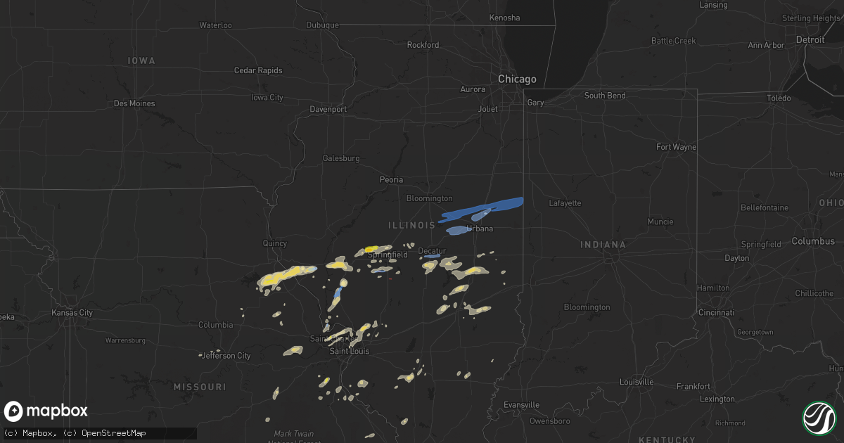
Hail Map in Illinois on July 21, 2020
Get this storm
July 21 map
$229
one time, instant access
Download today. No call, no setup
Keep the $229
Bought the map and want the full workflow? Apply the entire $229 to a subscription within 7 days. None of it is wasted.
Every map, not just this one
This buys you this map. Subscription and you get every map we run, in the markets you choose from a few cities to whole states to nationwide. Plus real-time alerts the moment a storm fires.
Contact data
Name, contact info, occupancy, even credit band for addresses in the footprint. You go from where it hit to who to call.
Become the source they trust
Unlimited branding weather history reports on demand. You already have the documented answer ready for the property owner, and you are the one who showed up with it.
Property data and RoofTrace estimates
Pull up any address you have got, its value and the exact code rules for that jurisdiction, straight from One Click Code. Then RoofTrace estimates the squares, pitch, and roof value, priced the way you price.
Storm reports in Illinois
Illinois
| Date | Description |
|---|---|
| 07/21/20205:54 PM CDT | Report of tree taking down power line on southside drive... Blocking road. |
| 07/21/20205:10 PM CDT | A local report indicates 65 MPH wind near LONG CREEK |
| 07/21/20205:00 PM CDT | Large tree down along county road 2400e. |
| 07/21/20204:45 PM CDT | Approx 4 inch tree limbs down into power lines in stonington. Winds est to 60 mph by emergency manager. |
| 07/21/20204:34 PM CDT | Approx 4 inch tree limbs down into power lines in edinburgh. Old power pole snapped on west side of town. Winds est to 60 mph by emergency manager. |
| 07/21/20204:27 PM CDT | Approx 4 inch tree limbs down into power lines in kincaid. Winds est to 60 mph by emergency manager. |
| 07/21/20204:25 PM CDT | Approx 4 inch tree limbs down into power lines in tovey. Winds est to 60 mph by emergency manager. |
| 07/21/20204:20 PM CDT | Numerous trees down. |
| 07/21/20204:20 PM CDT | Aprs mesonet |
| 07/21/20204:18 PM CDT | Power poles down. |
| 07/21/20204:18 PM CDT | Montgomery co. Emergency management reported a tornado on the ground near white oak. |
| 07/21/20204:08 PM CDT | Damage to grain bin and out building... 55 ft tall-12 in diameter tree down across road. |
| 07/21/20204:08 PM CDT | Reports of debris and power outages. |
| 07/21/20204:08 PM CDT | Reports of debris and power outages. |
| 07/21/20204:08 PM CDT | Damage to grain bin and out building... 55 ft tall-12 in diameter tree down across road. |
| 07/21/20204:08 PM CDT | Reports of debris and power outages. |
| 07/21/20204:07 PM CDT | A local report indicates 65 MPH wind near AUBURN |
| 07/21/20204:00 PM CDT | Trees downed. |
| 07/21/20203:48 PM CDT | Numerous trees down around town... Some blocking roads. Also... A couple of sheds were damaged. |
| 07/21/20203:32 PM CDT | A local report indicates 1.00 inch wind near PLEASANT PLAINS |
| 07/21/20203:27 PM CDT | Several trees down on powerlines in the city. Also... Pea to marble size hail reported. |
| 07/21/20203:20 PM CDT | A couple trees down on the west side of town. |
| 07/21/20203:15 PM CDT | 12in tree limb fell on homeowners deck... Damaging it. |
| 07/21/20203:13 PM CDT | Several trees blown down in town as well as some power outages. |
| 07/21/20202:36 PM CDT | Numerous trees blown down around town. One tree fell onto a house. |
| 07/21/20201:43 PM CDT | Numerous tree branches down... Leaning power poles... Power out in town. |
| 07/21/202011:35 AM CDT | A local report indicates 63 MPH wind near 1 ESE RANTOUL |
| 07/21/202011:34 AM CDT | Numerous tree branches down... Leaning power poles... Power out in town. |
| 07/21/202011:30 AM CDT | Multiple structures damaged |
| 07/21/202011:01 AM CDT | Multiple trees and tree branches down in town. One tree smashed the park pavilion. |
| 07/21/20205:48 AM CDT | At 1048 AM CDT, a severe thunderstorm was located near Weldon, or 11 miles northeast of Clinton, moving east at 40 mph. HAZARD...60 mph wind gusts. SOURCE...Radar indicated. IMPACT...Expect damage to roofs, siding, and trees. Locations impacted include... Mahomet, Farmer City, Fisher, Mansfield, Lake Of The Woods, Bellflower, De Witt, Foosland, Dewey and Galesville.This includes Interstate 74 between mile markers 152 and 178. |
| 07/21/202012:14 AM CDT | At 514 PM CDT, a severe thunderstorm was located near Long Creek, or near Decatur, moving northeast at 50 mph. HAZARD...60 mph wind gusts. SOURCE...Radar indicated. IMPACT...Expect damage to roofs, siding, and trees. Locations impacted include... Decatur, Monticello, Tuscola, Sullivan, Mount Zion, Forsyth, Arthur, Bement, Cerro Gordo, Bethany, Long Creek, Atwood, Lovington, Argenta, Oreana, Pesotum, Dalton City, Hammond, White Heath and Bourbon.This includes the following highways... Interstate 57 between mile markers 206 and 223. Interstate 72 between mile markers 142 and 169. |
| 07/20/202011:39 PM CDT | At 438 PM CDT, severe thunderstorms were located along a line extending from near Mechanicsburg to Taylorville, moving east at 45 mph. HAZARD...60 mph wind gusts. SOURCE...Radar indicated. IMPACT...Expect damage to roofs, siding, and trees. Locations impacted include... Decatur, Taylorville, Mount Zion, Forsyth, Moweaqua, Harristown, Long Creek, Blue Mound, Macon, Stonington, Illiopolis, Niantic, Mechanicsburg, Mount Auburn, Buffalo, Boody, Willeys, Elwin, Decatur Airport and Hervey City.This includes Interstate 72 between mile markers 114 and 143. |
| 07/20/202010:45 PM CDT | At 344 PM CDT, severe thunderstorms were located along a line extending from near Alexander to near Palmyra, moving northeast at 40 mph. HAZARD...60 mph wind gusts and quarter size hail. SOURCE...Radar indicated. IMPACT...Hail damage to vehicles is expected. Expect wind damage to roofs, siding, and trees. Locations impacted include... Springfield, Chatham, Alexander, Auburn, Sherman, Rochester, Riverton, Pawnee, Williamsville, New Berlin, Waverly, Divernon, Loami, Franklin, Jerome, Southern View, Leland Grove, Grandview, Spaulding and Thayer.This includes the following highways... Interstate 55 between mile markers 77 and 106. Interstate 72 between mile markers 73 and 109. |
| 07/20/202010:38 PM CDT | At 338 PM CDT, a severe thunderstorm was located near Dorsey, moving northeast at 15 mph. HAZARD...60 mph wind gusts and quarter size hail. SOURCE...Radar indicated. IMPACT...Hail damage to vehicles is expected. Expect wind damage to roofs, siding, and trees. Locations impacted include... Staunton, Mount Olive, Bunker Hill, Benld, Worden, Livingston, Wilsonville, Sawyerville, Mount Clare, Prairietown, Dorsey, White City, Williamson, Royal Lakes, Dorchester, Pruett and Fosterburg.This includes Interstate 55 in Illinois between exits 41 and 44. |
| 07/20/202010:20 PM CDT | At 320 PM CDT, a severe thunderstorm was located over Murphysboro, moving northeast at 30 mph. HAZARD...60 mph wind gusts and quarter size hail. SOURCE...Radar indicated. IMPACT...Hail damage to vehicles is expected. Expect wind damage to roofs, siding, and trees. Locations impacted include... Carbondale, Murphysboro, De Soto, Elkville, Hurst and Vergennes. |
| 07/20/202010:12 PM CDT | At 312 PM CDT, a severe thunderstorm was located over Pleasant Plains, or 15 miles southeast of Virginia, moving northeast at 30 mph. HAZARD...60 mph wind gusts and quarter size hail. SOURCE...Radar indicated. IMPACT...Hail damage to vehicles is expected. Expect wind damage to roofs, siding, and trees. Locations impacted include... Springfield, Sherman, Riverton, Athens, Williamsville, Pleasant Plains, Tallula, Spaulding, Berlin, Cantrall, Capital Airport, Salisbury, Farmingdale, Lincolns New Salem and Fancy Prairie.This includes the following highways... Interstate 55 between mile markers 100 and 107. Interstate 72 between mile markers 80 and 81. |
| 07/20/20209:51 PM CDT | At 251 PM CDT, a severe thunderstorm was located over Hardin, moving north at 25 mph. HAZARD...60 mph wind gusts and nickel size hail. SOURCE...Radar indicated. IMPACT...Expect damage to roofs, siding, and trees. Locations impacted include... White Hall, Carrollton, Roodhouse, Hardin, Patterson, Kampsville, Eldred, Hillview, Belltown, Berdan, Haypress, Barrow, Walkersville, Woody and Michael. |
| 07/20/20209:41 PM CDT | At 241 PM CDT, a severe thunderstorm was located near Pittsfield, moving east at 35 mph. HAZARD...60 mph wind gusts and quarter size hail. SOURCE...Radar indicated. IMPACT...Hail damage to vehicles is expected. Expect wind damage to roofs, siding, and trees. Locations impacted include... Jacksonville, Virginia, Winchester, Alexander, Ashland, Waverly, Bluffs, Franklin, Murrayville, Woodson, Chapin, Arenzville, Manchester, Alsey, Naples, Exeter, Literberry, South Jacksonville, Philadelphia and Concord.This includes Interstate 72 between mile markers 43 and 79. |
| 07/20/20209:28 PM CDT | At 228 PM CDT, a severe thunderstorm was located 8 miles west of Grafton, moving north at 25 mph. HAZARD...60 mph wind gusts and penny size hail. SOURCE...Radar indicated. IMPACT...Expect damage to roofs, siding, and trees. Locations impacted include... Hardin, Fieldon, Batchtown, Brussels, Meppen, Beechville and Nutwood.This also includes Pere Marquette State Park. |
| 07/20/20209:27 PM CDT | At 227 PM CDT, a severe thunderstorm was located over St. Charles, moving northeast at 20 mph. HAZARD...60 mph wind gusts and nickel size hail. SOURCE...Radar indicated. IMPACT...Expect damage to roofs, siding, and trees. Locations impacted include... St. Charles, St. Peters, Florissant, Alton, Maryland Heights, Hazelwood, Bridgeton, Berkeley, Black Jack, Spanish Lake, Lambert-St. Louis International Airport, East Alton, West Alton, Portage Des Sioux, Orchard Farms and Kampville.This includes Interstate 70 in Missouri between exits 227 and 231. This also includes Confluence State Park and First Missouri StateCapitol Historic Site. |
| 07/20/20209:12 PM CDT | At 211 PM CDT, severe thunderstorms were located along a line extending from near Barry to near Atlas to near Curryville, moving east at 30 mph. HAZARD...60 mph wind gusts and quarter size hail. SOURCE...Radar indicated. IMPACT...Hail damage to vehicles is expected. Expect wind damage to roofs, siding, and trees. Locations impacted include... Bowling Green, Pittsfield, Louisiana, Barry, Griggsville, Pleasant Hill, Atlas, Clarksville, Pike, Tarrants, Belleview, Independence, Bedford, Montezuma, Martinsburg, Perry, New Canton, Nebo, Milton and Baylis.This includes Interstate 72 between exits 20 and 35. |
| 07/20/20209:07 PM CDT | At 206 PM CDT, a severe thunderstorm was located over St. Peters, moving northeast at 25 mph. HAZARD...60 mph wind gusts and penny size hail. SOURCE...Radar indicated. IMPACT...Expect damage to roofs, siding, and trees. Locations impacted include... O'Fallon, St. Charles, St. Peters, Dardenne Prairie, Weldon Spring, Cottleville, Orchard Farms, Harvester, Brussels, Golden Eagle, Deer Plain and Kampville.This includes Interstate 70 in Missouri between exits 217 and 229. This also includes First Missouri State Capitol Historic Site. |
| 07/20/20208:36 PM CDT | At 135 PM CDT, severe thunderstorms were located along a line extending from New London to near Frankford to near Spencerburg, moving east at 25 mph. HAZARD...60 mph wind gusts and quarter size hail. SOURCE...Radar indicated. IMPACT...Hail damage to vehicles is expected. Expect wind damage to roofs, siding, and trees. Locations impacted include... Hannibal, Louisiana, Barry, New London, Atlas, Frankford, Pike, Curryville, Spencerburg, Tarrants, Hull, New Canton, Kinderhook, Baylis, El Dara, Saverton, New Hartford, Summer Hill, Ilasco and Rockport.This includes Interstate 72 between exits 10 and 20. |
| 07/20/20208:32 PM CDT | At 132 AM CDT, a severe thunderstorm was located over Cedar Hill Lakes, moving east at 20 mph. HAZARD...60 mph wind gusts and nickel size hail. SOURCE...Radar indicated. IMPACT...Expect damage to roofs, siding, and trees. Locations impacted include... Arnold, Festus, Pevely, Crystal City, Herculaneum, Hillsboro, Byrnes Mill, Barnhart, Cedar Hill, Antonia, Oakville, Cedar Hill Lakes, House Springs, Dittmer, Horine, Imperial, Scotsdale, Kimmswick, Otto and Morse Mill.This includes Interstate 55 in Missouri between exits 175 and 191. This also includes Mastodon Historic Site, Sandy Creek Covered BridgeHistoric Site, and Gov. Dunklin's Grave Historic Site. |
| 07/20/20208:17 PM CDT | At 117 PM EDT, a severe thunderstorm was located near Boswell, or 11 miles southwest of Fowler, moving east at 45 mph. HAZARD...70 mph wind gusts. SOURCE...Radar indicated. IMPACT...Expect considerable tree damage. Damage is likely to mobile homes, roofs, and outbuildings. Locations impacted include... Fowler, Otterbein, Oxford, Boswell, Earl Park, Ambia, Dunnington, Templeton, Wadena, Swanington and Raub. |
All States Impacted by Hail Map on July 21, 2020
Cities Impacted by Hail Map on July 21, 2020
- Callao, VA
- Lottsburg, VA
- Heathsville, VA
- Woodlawn, VA
- Cobbs Creek, VA
- Roanoke, VA
- Boones Mill, VA
- Rockholds, KY
- Williamsburg, KY
- Blairsville, GA
- Otis, CO
- Henderson, TN
- Buford, WY
- Laramie, WY
- Cheyenne, WY
- Woodford, VA
- Brent, AL
- Marion, AL
- North Wilkesboro, NC
- Center, MO
- Wheatland, WY
- Camden Wyoming, DE
- Keysville, VA
- Cascade, VA
- Murfreesboro, TN
- Brooksville, KY
- Augusta, KY
- Georgetown, OH
- Laurel, MD
- Fulton, MD
- Chetek, WI
- Weyerhaeuser, WI
- Chambersburg, PA
- Spring Grove, VA
- Clover, SC
- Belmont, NC
- Charlotte, NC
- Pickens, SC
- Sunset, SC
- Middletown, MO
- Bellflower, MO
- Cartersville, VA
- Birchleaf, VA
- Bee, VA
- Nashville, IL
- Senatobia, MS
- Lawrenceburg, TN
- Oneida, TN
- Dutton, VA
- Collinsville, AL
- Dawson, AL
- Jamestown, IN
- Crawfordsville, IN
- Las Vegas, NM
- Garita, NM
- Pontotoc, MS
- Connelly Springs, NC
- Hillsdale, WY
- Carpenter, WY
- Burns, WY
- Sugar City, CO
- Ordway, CO
- Karval, CO
- De Soto, MO
- Elberton, GA
- Travelers Rest, SC
- Taylors, SC
- Hodges, SC
- Sterling, CO
- Loganville, GA
- Fredericksburg, VA
- Stafford, VA
- Athens, TN
- Englewood, TN
- Niota, TN
- Honea Path, SC
- Florissant, MO
- Saint Charles, MO
- Saint Louis, MO
- Maryland Heights, MO
- Earth City, MO
- Bridgeton, MO
- Hazelwood, MO
- New Kent, VA
- King William, VA
- Bowling Green, KY
- Hohenwald, TN
- Goree, TX
- Sidney, NE
- Peetz, CO
- Akron, CO
- Port Tobacco, MD
- La Plata, MD
- Colfax, WI
- Mexico, MO
- Pocomoke City, MD
- Snow Hill, MD
- Ashley, IL
- Saint Peters, MO
- Humboldt, IL
- Oakland, IL
- Sullivan, IL
- Mattoon, IL
- Charleston, IL
- Windsor, IL
- Gays, IL
- Arcola, IL
- Neoga, IL
- Strasburg, IL
- Stewardson, IL
- Springfield, IL
- Cantrall, IL
- Fort Morgan, CO
- Snyder, CO
- Weldona, CO
- Newberry, FL
- New London, MO
- Whitestown, IN
- Lebanon, IN
- Sheridan, IN
- Cambridge, MD
- Woolford, MD
- Jerseyville, IL
- Grafton, IL
- Batesburg, SC
- Monetta, SC
- Morganton, NC
- Valdese, NC
- King George, VA
- Cross City, FL
- Bethalto, IL
- Moro, IL
- East Alton, IL
- Carrollton, AL
- Reform, AL
- Gordo, AL
- Aliceville, AL
- Garrett, WY
- Fe Warren Afb, WY
- Chugwater, WY
- Bayard, NE
- Harrisburg, NE
- Jewett, IL
- Newton, IL
- Hidalgo, IL
- Wheeler, IL
- Henderson, MD
- Marydel, MD
- Sudlersville, MD
- Barclay, MD
- Hendersonville, NC
- Merino, CO
- Atwood, CO
- Kinderhook, IL
- Ashburn, MO
- Frankford, MO
- Perry, MO
- New Canton, IL
- Louisiana, MO
- Piedmont, AL
- Centre, AL
- Young Harris, GA
- Quanah, TX
- Auburn, KY
- Hardy, VA
- Glenrock, WY
- Susanville, CA
- Old Town, FL
- Culleoka, TN
- Lodgepole, NE
- Bushnell, NE
- South Charleston, OH
- Moweaqua, IL
- Dalton City, IL
- Macon, IL
- Assumption, IL
- Blue Mound, IL
- Teutopolis, IL
- Sigel, IL
- Vance, AL
- Villa Rica, GA
- Whitesburg, GA
- Winston, GA
- Carrollton, GA
- Trinidad, CO
- Montrose, IL
- Suches, GA
- Ladoga, IN
- New Ross, IN
- Marydel, DE
- Chappell, NE
- Barry, IL
- Mount Pleasant, NC
- Concord, NC
- Kershaw, SC
- Fairfax Station, VA
- Lorton, VA
- Springfield, VA
- Steinhatchee, FL
- Algona, IA
- Wesley, IA
- Lusk, WY
- Bent Mountain, VA
- Pisgah, AL
- Mode, IL
- Beecher City, IL
- Shelbyville, IL
- Auxvasse, MO
- Atlanta, GA
- Canutillo, TX
- Isabel, SD
- Gordonsville, VA
- Louisa, VA
- Brierfield, AL
- Centralia, IL
- Raton, NM
- Douglas, WY
- Winchester, IL
- Pampa, TX
- Greer, SC
- Menlo, GA
- Marthasville, MO
- Washington, MO
- New Haven, MO
- Rice, VA
- Kimball, NE
- Royston, GA
- New Raymer, CO
- Helenwood, TN
- Robbins, TN
- Lovington, IL
- Bethany, IL
- Yuma, CO
- Williamsburg, VA
- Mcminnville, TN
- Moulton, AL
- Town Creek, AL
- McConnellsburg, PA
- Oakdale, IL
- Du Bois, IL
- Richview, IL
- Mayodan, NC
- Stoneville, NC
- Madison, NC
- Somerville, TN
- Dieterich, IL
- Yale, IL
- Vandalia, MO
- Pittsfield, IL
- Rockport, IL
- Vintondale, PA
- Bloomington, IN
- Unionville, IN
- Loami, IL
- Waverly, IL
- Saluda, VA
- Church View, VA
- Mascot, VA
- Sells, AZ
- Port Allen, LA
- Stanardsville, VA
- Madison, VA
- Disputanta, VA
- Stony Creek, VA
- Waverly, VA
- Petersburg, VA
- Carson, VA
- Flat Rock, AL
- Higdon, AL
- West Point, VA
- Mattaponi, VA
- Shacklefords, VA
- Barhamsville, VA
- Carbon Hill, AL
- Nauvoo, AL
- Bankston, AL
- White Plains, MD
- Pomfret, MD
- Buffalo, WY
- West Blocton, AL
- Dalton, GA
- Chatsworth, GA
- Trinchera, CO
- Stoneham, CO
- Festus, MO
- Rockfield, KY
- Leicester, NC
- Eldred, IL
- Commerce, GA
- Jefferson, GA
- Marion, NC
- Huntersville, NC
- Summerville, GA
- Gaylesville, AL
- Lyerly, GA
- Breezewood, PA
- Harrisonville, PA
- Warfordsburg, PA
- Crystal Spring, PA
- Needmore, PA
- Salem, MO
- Flat Rock, NC
- Hawkinsville, GA
- Perry, FL
- Edwardsville, IL
- Worden, IL
- Wood River, IL
- Granite City, IL
- Hartford, IL
- Cottage Hills, IL
- Dorsey, IL
- Roxana, IL
- South Roxana, IL
- Silva, MO
- Alachua, FL
- Henrico, VA
- Richmond, VA
- Brevard, NC
- Pisgah Forest, NC
- Alexander, IL
- Ashland, IL
- Pleasant Plains, IL
- Wana, WV
- Burton, WV
- Russellville, KY
- Topping, VA
- Black Mountain, NC
- Mooresboro, NC
- Springfield, TN
- Orlinda, TN
- Franklin, KY
- Adairville, KY
- Red Bud, IL
- Waterloo, IL
- California, MO
- Mineral, VA
- Patrick, SC
- Chesterfield, SC
- Sharon, SC
- Divide, CO
- Church Road, VA
- Sutherland, VA
- Blue Rock, OH
- Duncan Falls, OH
- New Concord, OH
- Zanesville, OH
- Chandlersville, OH
- Sulligent, AL
- Tunica, MS
- Kampsville, IL
- Pearl, IL
- Lancaster, VA
- Lewisburg, KY
- Woodbine, KY
- O'Fallon, MO
- Brussels, IL
- Golden Eagle, IL
- West Columbia, SC
- Jamestown, TN
- Allardt, TN
- Leesville, SC
- Oldtown, MD
- Water Valley, MS
- Wilsons, VA
- Blackstone, VA
- Greenville, SC
- Clarksville, MD
- Columbia, MD
- Marietta, GA
- Kennesaw, GA
- Milford, CA
- Woodlawn, IL
- Clyde, NC
- Waynesville, NC
- Trappe, MD
- Curryville, MO
- Griggsville, IL
- Vinton, VA
- Valley Head, AL
- Westville, SC
- Buffalo, IL
- Tishomingo, MS
- Urbanna, VA
- Cedartown, GA
- High Hill, MO
- Truxton, MO
- Jonesburg, MO
- Shady Dale, GA
- Newborn, GA
- York, SC
- Powhatan, VA
- Grenada, MS
- Proctor, AR
- Bosler, WY
- Lascassas, TN
- Burnsville, NC
- Washington, GA
- Tignall, GA
- Danbury, WI
- Webster, WI
- Saint Thomas, PA
- Carrollton, IL
- Winder, GA
- Cotopaxi, CO
- Murphy, NC
- Byers, CO
- Ellington, MO
- Hiawassee, GA
- Leesburg, AL
- Trenton, FL
- Sparks, NV
- Kingfisher, OK
- Rio, WV
- Olmstead, KY
- Idalou, TX
- Gloucester, VA
- North, VA
- Hallieford, VA
- Granite Canon, WY
- Arthur, IL
- Cuba, MO
- Sherman, IL
- Mount Crawford, VA
- Bridgewater, VA
- Harrisonburg, VA
- Dayton, VA
- Lake Junaluska, NC
- Duck Hill, MS
- Brookwood, AL
- Spotsylvania, VA
- Partlow, VA
- Goochland, VA
- Preston, MD
- Fieldon, IL
- Chillicothe, TX
- Carr, CO
- Nunn, CO
- Mount Pulaski, IL
- Mechanicsville, VA
- Mill Spring, NC
- Fults, IL
- Salem, VA
- Prince George, VA
- Perryville, MO
- Sedgewickville, MO
- Homer City, PA
- Ebensburg, PA
- Nanty Glo, PA
- Twin Rocks, PA
- Greenville, FL
- Woodland Park, CO
- Sedalia, CO
- New Berlin, IL
- Jacksonville, IL
- Holton, IN
- Eagle Butte, SD
- Janesville, CA
- Forest Park, GA
- White Hall, IL
- Roodhouse, IL
- Rockville, IN
- Russellville, IN
- Bluffs, IL
- Murrayville, IL
- Woodland, MS
- Mantee, MS
- Callaway, VA
- Floyd, VA
- Keokee, VA
- Goodview, VA
- Rural Hall, NC
- Detroit, AL
- Huntsville, TN
- Murphysboro, IL
- Hinckley, MN
- Amelia Court House, VA
- Meherrin, VA
- Green Bay, VA
- Manchester, KY
- Monroe, GA
- Blackwell, MO
- Cadet, MO
- Houston, MS
- Wakefield, VA
- Wiggins, CO
- Chatham, IL
- Hartselle, AL
- Danville, AL
- Hoyleton, IL
- Danielsville, GA
- Carnesville, GA
- Harrisburg, NC
- Manitou Springs, CO
- Aberdeen, MS
- Hayesville, NC
- Williamson, GA
- Onancock, VA
- Patterson, MO
- Piedmont, MO
- Hartwell, GA
- Fountain Run, KY
- Tuscola, IL
- Camargo, IL
- Hurlock, MD
- Hamersville, OH
- Centertown, MO
- Newland, NC
- Collettsville, NC
- Seymour, TX
- Crawfordsville, AR
- Wake, VA
- Cherokee, AL
- Swoope, VA
- Gum Spring, VA
- Sandy Hook, VA
- Reagan, TN
- Ocate, NM
- Hillsboro, MO
- Cave Spring, GA
- Hamilton, AL
- Woodson, IL
- Chapin, IL
- Wheatland, IN
- Rock Hill, SC
- Tallahassee, FL
- Wappapello, MO
- Flat Lick, KY
- Decatur, GA
- New Douglas, IL
- Eden, NC
- Sedley, VA
- Crozet, VA
- Big Springs, NE
- Eldorado, OK
- Welcome, MD
- Bryans Road, MD
- Indian Head, MD
- West Salem, IL
- Lewisburg, TN
- Unionville, TN
- Chapel Hill, TN
- Altamont, IL
- Oneida, KY
- Big Creek, KY
- Forest City, NC
- Dittmer, MO
- Marietta, SC
- Sand Fork, WV
- Brightwood, VA
- Oakpark, VA
- Bloomsdale, MO
- Arab, AL
- Free Union, VA
- Brentwood, TN
- Fairfield, IL
- Prairie Du Rocher, IL
- Spruce Pine, NC
- Franklin, IL
- Midlothian, VA
- Chesterfield, VA
- Rutherfordton, NC
- Earlysville, VA
- Charlottesville, VA
- Mannington, WV
- Metz, WV
- Fairview, WV
- Cullman, AL
- Hillview, IL
- New Castle, VA
- Leighton, AL
- Rantoul, IL
- Marshall, IL
- Savannah, TN
- Randolph, AL
- Thorsby, AL
- Maplesville, AL
- Jemison, AL
- Belsano, PA
- Columbia, VA
- Kents Store, VA
- Riceville, TN
- Stanley, NC
- Mount Holly, NC
- Gastonia, NC
- West Alton, MO
- Craigsville, VA
- Camden, WV
- Campobello, SC
- Lyman, SC
- Inman, SC
- McCormick, SC
- Illiopolis, IL
- Gosport, IN
- Montross, VA
- Florence, AL
- Lake Lure, NC
- Houlka, MS
- Fork Union, VA
- Palmyra, VA
- Goldsboro, MD
- Ingleside, MD
- Hartly, DE
- Felton, DE
- Church Hill, MD
- Alhambra, IL
- Athens, GA
- Arnoldsville, GA
- Watkinsville, GA
- Winterville, GA
- Ellijay, GA
- Paris, IL
- Dyke, VA
- Champlain, VA
- Warsaw, VA
- Crowell, TX
- Rayle, GA
- Fleming, CO
- Moorefield, WV
- Quantico, VA
- Hickory Grove, SC
- Ennice, NC
- Wayne City, IL
- Sims, IL
- Norman, IN
- Freetown, IN
- Surry, VA
- Port Royal, VA
- Bowling Green, VA
- Chester, SC
- Shelby, NC
- Ellenboro, NC
- Mentone, AL
- Waterloo, SC
- Cross Hill, SC
- Lexington Park, MD
- Farnham, VA
- Ford, VA
- Pinebluff, NC
- Bethlehem, GA
- Kane, IL
- Greenville, MO
- Hildebran, NC
- Vina, AL
- Jetersville, VA
- Coulterville, IL
- Stephens, GA
- Greensboro, AL
- Virden, IL
- Auburn, IL
- Thayer, IL
- Farmville, VA
- Cumberland, VA
- Shumway, IL
- Saint Elmo, IL
- Columbia, TN
- Brocton, IL
- Catawba, VA
- Williamsville, MO
- Bostic, NC
- Jefferson City, MO
- Galax, VA
- Bowersville, GA
- Rochester, IL
- Ninety Six, SC
- Greenwood, SC
- Woodstock, GA
- Cottondale, AL
- Helen, GA
- Felicity, OH
- Foster, KY
- Russellville, OH
- Independence, VA
- Casar, NC
- Frederick, OK
- Sparta, GA
- Staunton, IL
- Fort Payne, AL
- Rutledge, GA
- Newman, IL
- Effingham, IL
- Pioneer, TN
- Montgomery City, MO
- Liberty, SC
- Girdletree, MD
- Imperial, NE
- Haysi, VA
- Ellettsville, IN
- Pawnee, IL
- Weems, VA
- Staunton, VA
- Cloverport, KY
- Washington, DC
- Chevy Chase, MD
- Groom, TX
- Chester, VA
- Hopewell, VA
- Colonial Heights, VA
- Smithfield, VA
- Windsor, VA
- Ider, AL
- Glenarm, IL
- Divernon, IL
- Federalsburg, MD
- Denton, MD
- Bridgeville, DE
- Dewey, IL
- Arrowsmith, IL
- Ludlow, IL
- Mahomet, IL
- Clinton, IL
- Bellflower, IL
- Farmer City, IL
- Foosland, IL
- Fisher, IL
- Hoopeston, IL
- Le Roy, IL
- Rossville, IL
- Rankin, IL
- Gifford, IL
- Dewitt, IL
- Penfield, IL
- Potomac, IL
- Paxton, IL
- Mansfield, IL
- De Land, IL
- Champaign, IL
- Bondville, IL
- Seymour, IL
- White Heath, IL
- Monticello, IL
- Thomasboro, IL
- Mt Zion, IL
- Decatur, IL
- Lafayette, IN
- Dayton, IN
- Alexandria, IN
- Muncie, IN
- Albany, IN
- Gaston, IN
- Yorktown, IN
- Anderson, IN
- Daleville, IN
- Logansport, IN
- Onward, IN
- Walton, IN
- Galveston, IN
- Camden, IN
- Peru, IN
- Gallitzin, PA
- Lilly, PA
- Loretto, PA
- Cresson, PA
- Johnstown, PA
- Windber, PA
- Fort Loudon, PA
- Cascade, CO
- Colorado Springs, CO
- Strasburg, CO
- Bellvue, CO


