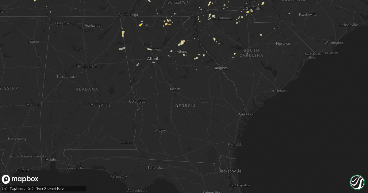
Hail Map in Georgia on July 21, 2020
Get this storm
July 21 map
$229
one time, instant access
Download today. No call, no setup
Keep the $229
Bought the map and want the full workflow? Apply the entire $229 to a subscription within 7 days. None of it is wasted.
Every map, not just this one
This buys you this map. Subscription and you get every map we run, in the markets you choose from a few cities to whole states to nationwide. Plus real-time alerts the moment a storm fires.
Contact data
Name, contact info, occupancy, even credit band for addresses in the footprint. You go from where it hit to who to call.
Become the source they trust
Unlimited branding weather history reports on demand. You already have the documented answer ready for the property owner, and you are the one who showed up with it.
Property data and RoofTrace estimates
Pull up any address you have got, its value and the exact code rules for that jurisdiction, straight from One Click Code. Then RoofTrace estimates the squares, pitch, and roof value, priced the way you price.
Storm reports in Georgia
Georgia
| Date | Description |
|---|---|
| 07/21/20206:00 PM CDT | Multiple trees down. Some shingles halfway peeled on roof. |
| 07/21/20203:45 PM CDT | Large tree blown down in northern marietta reported by local media |
| 07/21/20203:30 PM CDT | A couple trees were reported down in the vacinity of writes mill rd and carlan rd in southeastern banks county |
| 07/21/20203:20 PM CDT | A couple trees reported down south of commerce. |
| 07/21/20203:20 PM CDT | A local report indicates 1.50 inch wind near 5 S DAWNVILLE |
| 07/21/20203:15 PM CDT | 4 total trees down. 1 large oak down on house. |
| 07/21/20203:02 PM CDT | Several small trees down north of sandy springs... Blocking the roadway near spalding dr and preachtree dunwoody rd |
| 07/21/20202:58 PM CDT | At least 15 trees were downed in sharpsburg in the 200 block of marion beavers road and a few surrounding areas. |
| 07/21/20202:58 PM CDT | Tree down off hwy 441 near old athens dr |
| 07/21/20202:40 PM CDT | Reports of multiple trees down in the area around winder... Including one down on a home on hickeria way... Ne of town. |
| 07/21/20202:25 PM CDT | 3 trees were reported down on blackmon farm road near pecan grove road. |
| 07/21/20202:15 PM CDT | Minor roof damage caused by strong winds to a home on livingston ct near winder |
| 07/21/202012:25 PM CDT | Public reported one tree down on clayton road and another down on marie drive. |
| 07/21/202011:56 AM CDT | Public reported golf ball size hail fell for 3 to 4 mintues near lake trahlyta. |
| 07/21/202011:55 AM CDT | Public reported quarter size hail at a location on allison circle... Lasting 3-5 minutes. Hail caused damage to camper ac unit. |
| 07/21/202011:55 AM CDT | Public reported quarter size hail at a location on allison circle... Lasting 3-5 minutes. Hail caused damage to camper ac unit. |
| 07/21/202011:48 AM CDT | Public reported accumulating 1.50 inch hail at a location off sullivan trail road... Lasting more than five minutes. |
| 07/21/20207:52 AM CDT | At 1251 PM EDT, a severe thunderstorm was located over Vogel State Park, or 7 miles south of Blairsville, and is nearly stationary. HAZARD...60 mph wind gusts and quarter size hail. SOURCE...Radar indicated. IMPACT...Hail damage to vehicles is expected. Expect wind damage to roofs, siding, and trees. Locations impacted include... Owltown, Woods Hole Shelter, Blood Mountain Shelter, Vogel State Park, Brasstown Bald and Track Rock. |
| 07/20/202011:53 PM CDT | At 453 PM CDT, a severe thunderstorm was located near Moshat, or 7 miles west of Forney, and is nearly stationary. HAZARD...60 mph wind gusts and nickel size hail. SOURCE...Radar indicated. IMPACT...Expect damage to roofs, siding, and trees. Locations impacted include... Centre, Forney, Pleasant Gap, Tennala, Moshat, Ball Flat, Western Weiss Lake, Eastern Weiss Lake and Coloma. |
| 07/20/202011:19 PM CDT | At 419 PM EDT, a severe thunderstorm was located near Pulaski State Prison, or near Hawkinsville, moving southwest at 10 mph. HAZARD...60 mph wind gusts and quarter size hail. SOURCE...Radar indicated. IMPACT...Hail damage to vehicles is expected. Expect wind damage to roofs, siding, and trees. Locations impacted include... Hawkinsville, Browndale, Wallace, Tippettville, Mock Springs, Klondike and Finleyson. |
| 07/20/202011:18 PM CDT | At 418 PM EDT, a severe thunderstorm was located over Commerce, and is nearly stationary. HAZARD...60 mph wind gusts and quarter size hail. SOURCE...Radar indicated. IMPACT...Hail damage to vehicles is expected. Expect wind damage to roofs, siding, and trees. Locations impacted include... Jefferson, Commerce, Maysville, Arcade, Nicholson, Ila, Pocataligo, Peach State Speedway, Apple Valley and Banks Crossing. |
| 07/20/202011:10 PM CDT | At 410 PM EDT, a severe thunderstorm was located over Hapeville, or 7 miles south of Atlanta, and is nearly stationary. HAZARD...60 mph wind gusts and quarter size hail. SOURCE...Radar indicated. IMPACT...Hail damage to vehicles is expected. Expect wind damage to roofs, siding, and trees. Locations impacted include... Atlanta, East Point, Forest Park, Riverdale, College Park, Hapeville, Hartsfield-Jackson Airport, Cascade Heights, Lakewood Park and Conley. |
| 07/20/202011:08 PM CDT | At 407 PM EDT, a severe thunderstorm was located over North Georgia Speedway, or near Chatsworth, moving southwest at 20 mph. HAZARD...60 mph wind gusts and half dollar size hail. SOURCE...Radar indicated. IMPACT...Hail damage to vehicles is expected. Expect wind damage to roofs, siding, and trees. Locations impacted include... Dalton, Chatsworth, Eton, Crandall, Beaverdale, Dawnville, Sumac, Tilton and North Georgia Speedway. |
| 07/20/202010:17 PM CDT | At 317 PM EDT, a severe thunderstorm was located near Celeste, or near Washington, and is nearly stationary. HAZARD...60 mph wind gusts and half dollar size hail. SOURCE...Radar indicated. IMPACT...Hail damage to vehicles is expected. Expect wind damage to roofs, siding, and trees. Locations impacted include... Washington, Tignall, Rayle, Jacksons Crossroads, Mallorysville, Newtown, Delhi, Norman, Danburg, Celeste and Floral Hill. |
All States Impacted by Hail Map on July 21, 2020
Cities Impacted by Hail Map on July 21, 2020
- Callao, VA
- Lottsburg, VA
- Heathsville, VA
- Woodlawn, VA
- Cobbs Creek, VA
- Roanoke, VA
- Boones Mill, VA
- Rockholds, KY
- Williamsburg, KY
- Blairsville, GA
- Otis, CO
- Henderson, TN
- Buford, WY
- Laramie, WY
- Cheyenne, WY
- Woodford, VA
- Brent, AL
- Marion, AL
- North Wilkesboro, NC
- Center, MO
- Wheatland, WY
- Camden Wyoming, DE
- Keysville, VA
- Cascade, VA
- Murfreesboro, TN
- Brooksville, KY
- Augusta, KY
- Georgetown, OH
- Laurel, MD
- Fulton, MD
- Chetek, WI
- Weyerhaeuser, WI
- Chambersburg, PA
- Spring Grove, VA
- Clover, SC
- Belmont, NC
- Charlotte, NC
- Pickens, SC
- Sunset, SC
- Middletown, MO
- Bellflower, MO
- Cartersville, VA
- Birchleaf, VA
- Bee, VA
- Nashville, IL
- Senatobia, MS
- Lawrenceburg, TN
- Oneida, TN
- Dutton, VA
- Collinsville, AL
- Dawson, AL
- Jamestown, IN
- Crawfordsville, IN
- Las Vegas, NM
- Garita, NM
- Pontotoc, MS
- Connelly Springs, NC
- Hillsdale, WY
- Carpenter, WY
- Burns, WY
- Sugar City, CO
- Ordway, CO
- Karval, CO
- De Soto, MO
- Elberton, GA
- Travelers Rest, SC
- Taylors, SC
- Hodges, SC
- Sterling, CO
- Loganville, GA
- Fredericksburg, VA
- Stafford, VA
- Athens, TN
- Englewood, TN
- Niota, TN
- Honea Path, SC
- Florissant, MO
- Saint Charles, MO
- Saint Louis, MO
- Maryland Heights, MO
- Earth City, MO
- Bridgeton, MO
- Hazelwood, MO
- New Kent, VA
- King William, VA
- Bowling Green, KY
- Hohenwald, TN
- Goree, TX
- Sidney, NE
- Peetz, CO
- Akron, CO
- Port Tobacco, MD
- La Plata, MD
- Colfax, WI
- Mexico, MO
- Pocomoke City, MD
- Snow Hill, MD
- Ashley, IL
- Saint Peters, MO
- Humboldt, IL
- Oakland, IL
- Sullivan, IL
- Mattoon, IL
- Charleston, IL
- Windsor, IL
- Gays, IL
- Arcola, IL
- Neoga, IL
- Strasburg, IL
- Stewardson, IL
- Springfield, IL
- Cantrall, IL
- Fort Morgan, CO
- Snyder, CO
- Weldona, CO
- Newberry, FL
- New London, MO
- Whitestown, IN
- Lebanon, IN
- Sheridan, IN
- Cambridge, MD
- Woolford, MD
- Jerseyville, IL
- Grafton, IL
- Batesburg, SC
- Monetta, SC
- Morganton, NC
- Valdese, NC
- King George, VA
- Cross City, FL
- Bethalto, IL
- Moro, IL
- East Alton, IL
- Carrollton, AL
- Reform, AL
- Gordo, AL
- Aliceville, AL
- Garrett, WY
- Fe Warren Afb, WY
- Chugwater, WY
- Bayard, NE
- Harrisburg, NE
- Jewett, IL
- Newton, IL
- Hidalgo, IL
- Wheeler, IL
- Henderson, MD
- Marydel, MD
- Sudlersville, MD
- Barclay, MD
- Hendersonville, NC
- Merino, CO
- Atwood, CO
- Kinderhook, IL
- Ashburn, MO
- Frankford, MO
- Perry, MO
- New Canton, IL
- Louisiana, MO
- Piedmont, AL
- Centre, AL
- Young Harris, GA
- Quanah, TX
- Auburn, KY
- Hardy, VA
- Glenrock, WY
- Susanville, CA
- Old Town, FL
- Culleoka, TN
- Lodgepole, NE
- Bushnell, NE
- South Charleston, OH
- Moweaqua, IL
- Dalton City, IL
- Macon, IL
- Assumption, IL
- Blue Mound, IL
- Teutopolis, IL
- Sigel, IL
- Vance, AL
- Villa Rica, GA
- Whitesburg, GA
- Winston, GA
- Carrollton, GA
- Trinidad, CO
- Montrose, IL
- Suches, GA
- Ladoga, IN
- New Ross, IN
- Marydel, DE
- Chappell, NE
- Barry, IL
- Mount Pleasant, NC
- Concord, NC
- Kershaw, SC
- Fairfax Station, VA
- Lorton, VA
- Springfield, VA
- Steinhatchee, FL
- Algona, IA
- Wesley, IA
- Lusk, WY
- Bent Mountain, VA
- Pisgah, AL
- Mode, IL
- Beecher City, IL
- Shelbyville, IL
- Auxvasse, MO
- Atlanta, GA
- Canutillo, TX
- Isabel, SD
- Gordonsville, VA
- Louisa, VA
- Brierfield, AL
- Centralia, IL
- Raton, NM
- Douglas, WY
- Winchester, IL
- Pampa, TX
- Greer, SC
- Menlo, GA
- Marthasville, MO
- Washington, MO
- New Haven, MO
- Rice, VA
- Kimball, NE
- Royston, GA
- New Raymer, CO
- Helenwood, TN
- Robbins, TN
- Lovington, IL
- Bethany, IL
- Yuma, CO
- Williamsburg, VA
- Mcminnville, TN
- Moulton, AL
- Town Creek, AL
- McConnellsburg, PA
- Oakdale, IL
- Du Bois, IL
- Richview, IL
- Mayodan, NC
- Stoneville, NC
- Madison, NC
- Somerville, TN
- Dieterich, IL
- Yale, IL
- Vandalia, MO
- Pittsfield, IL
- Rockport, IL
- Vintondale, PA
- Bloomington, IN
- Unionville, IN
- Loami, IL
- Waverly, IL
- Saluda, VA
- Church View, VA
- Mascot, VA
- Sells, AZ
- Port Allen, LA
- Stanardsville, VA
- Madison, VA
- Disputanta, VA
- Stony Creek, VA
- Waverly, VA
- Petersburg, VA
- Carson, VA
- Flat Rock, AL
- Higdon, AL
- West Point, VA
- Mattaponi, VA
- Shacklefords, VA
- Barhamsville, VA
- Carbon Hill, AL
- Nauvoo, AL
- Bankston, AL
- White Plains, MD
- Pomfret, MD
- Buffalo, WY
- West Blocton, AL
- Dalton, GA
- Chatsworth, GA
- Trinchera, CO
- Stoneham, CO
- Festus, MO
- Rockfield, KY
- Leicester, NC
- Eldred, IL
- Commerce, GA
- Jefferson, GA
- Marion, NC
- Huntersville, NC
- Summerville, GA
- Gaylesville, AL
- Lyerly, GA
- Breezewood, PA
- Harrisonville, PA
- Warfordsburg, PA
- Crystal Spring, PA
- Needmore, PA
- Salem, MO
- Flat Rock, NC
- Hawkinsville, GA
- Perry, FL
- Edwardsville, IL
- Worden, IL
- Wood River, IL
- Granite City, IL
- Hartford, IL
- Cottage Hills, IL
- Dorsey, IL
- Roxana, IL
- South Roxana, IL
- Silva, MO
- Alachua, FL
- Henrico, VA
- Richmond, VA
- Brevard, NC
- Pisgah Forest, NC
- Alexander, IL
- Ashland, IL
- Pleasant Plains, IL
- Wana, WV
- Burton, WV
- Russellville, KY
- Topping, VA
- Black Mountain, NC
- Mooresboro, NC
- Springfield, TN
- Orlinda, TN
- Franklin, KY
- Adairville, KY
- Red Bud, IL
- Waterloo, IL
- California, MO
- Mineral, VA
- Patrick, SC
- Chesterfield, SC
- Sharon, SC
- Divide, CO
- Church Road, VA
- Sutherland, VA
- Blue Rock, OH
- Duncan Falls, OH
- New Concord, OH
- Zanesville, OH
- Chandlersville, OH
- Sulligent, AL
- Tunica, MS
- Kampsville, IL
- Pearl, IL
- Lancaster, VA
- Lewisburg, KY
- Woodbine, KY
- O'Fallon, MO
- Brussels, IL
- Golden Eagle, IL
- West Columbia, SC
- Jamestown, TN
- Allardt, TN
- Leesville, SC
- Oldtown, MD
- Water Valley, MS
- Wilsons, VA
- Blackstone, VA
- Greenville, SC
- Clarksville, MD
- Columbia, MD
- Marietta, GA
- Kennesaw, GA
- Milford, CA
- Woodlawn, IL
- Clyde, NC
- Waynesville, NC
- Trappe, MD
- Curryville, MO
- Griggsville, IL
- Vinton, VA
- Valley Head, AL
- Westville, SC
- Buffalo, IL
- Tishomingo, MS
- Urbanna, VA
- Cedartown, GA
- High Hill, MO
- Truxton, MO
- Jonesburg, MO
- Shady Dale, GA
- Newborn, GA
- York, SC
- Powhatan, VA
- Grenada, MS
- Proctor, AR
- Bosler, WY
- Lascassas, TN
- Burnsville, NC
- Washington, GA
- Tignall, GA
- Danbury, WI
- Webster, WI
- Saint Thomas, PA
- Carrollton, IL
- Winder, GA
- Cotopaxi, CO
- Murphy, NC
- Byers, CO
- Ellington, MO
- Hiawassee, GA
- Leesburg, AL
- Trenton, FL
- Sparks, NV
- Kingfisher, OK
- Rio, WV
- Olmstead, KY
- Idalou, TX
- Gloucester, VA
- North, VA
- Hallieford, VA
- Granite Canon, WY
- Arthur, IL
- Cuba, MO
- Sherman, IL
- Mount Crawford, VA
- Bridgewater, VA
- Harrisonburg, VA
- Dayton, VA
- Lake Junaluska, NC
- Duck Hill, MS
- Brookwood, AL
- Spotsylvania, VA
- Partlow, VA
- Goochland, VA
- Preston, MD
- Fieldon, IL
- Chillicothe, TX
- Carr, CO
- Nunn, CO
- Mount Pulaski, IL
- Mechanicsville, VA
- Mill Spring, NC
- Fults, IL
- Salem, VA
- Prince George, VA
- Perryville, MO
- Sedgewickville, MO
- Homer City, PA
- Ebensburg, PA
- Nanty Glo, PA
- Twin Rocks, PA
- Greenville, FL
- Woodland Park, CO
- Sedalia, CO
- New Berlin, IL
- Jacksonville, IL
- Holton, IN
- Eagle Butte, SD
- Janesville, CA
- Forest Park, GA
- White Hall, IL
- Roodhouse, IL
- Rockville, IN
- Russellville, IN
- Bluffs, IL
- Murrayville, IL
- Woodland, MS
- Mantee, MS
- Callaway, VA
- Floyd, VA
- Keokee, VA
- Goodview, VA
- Rural Hall, NC
- Detroit, AL
- Huntsville, TN
- Murphysboro, IL
- Hinckley, MN
- Amelia Court House, VA
- Meherrin, VA
- Green Bay, VA
- Manchester, KY
- Monroe, GA
- Blackwell, MO
- Cadet, MO
- Houston, MS
- Wakefield, VA
- Wiggins, CO
- Chatham, IL
- Hartselle, AL
- Danville, AL
- Hoyleton, IL
- Danielsville, GA
- Carnesville, GA
- Harrisburg, NC
- Manitou Springs, CO
- Aberdeen, MS
- Hayesville, NC
- Williamson, GA
- Onancock, VA
- Patterson, MO
- Piedmont, MO
- Hartwell, GA
- Fountain Run, KY
- Tuscola, IL
- Camargo, IL
- Hurlock, MD
- Hamersville, OH
- Centertown, MO
- Newland, NC
- Collettsville, NC
- Seymour, TX
- Crawfordsville, AR
- Wake, VA
- Cherokee, AL
- Swoope, VA
- Gum Spring, VA
- Sandy Hook, VA
- Reagan, TN
- Ocate, NM
- Hillsboro, MO
- Cave Spring, GA
- Hamilton, AL
- Woodson, IL
- Chapin, IL
- Wheatland, IN
- Rock Hill, SC
- Tallahassee, FL
- Wappapello, MO
- Flat Lick, KY
- Decatur, GA
- New Douglas, IL
- Eden, NC
- Sedley, VA
- Crozet, VA
- Big Springs, NE
- Eldorado, OK
- Welcome, MD
- Bryans Road, MD
- Indian Head, MD
- West Salem, IL
- Lewisburg, TN
- Unionville, TN
- Chapel Hill, TN
- Altamont, IL
- Oneida, KY
- Big Creek, KY
- Forest City, NC
- Dittmer, MO
- Marietta, SC
- Sand Fork, WV
- Brightwood, VA
- Oakpark, VA
- Bloomsdale, MO
- Arab, AL
- Free Union, VA
- Brentwood, TN
- Fairfield, IL
- Prairie Du Rocher, IL
- Spruce Pine, NC
- Franklin, IL
- Midlothian, VA
- Chesterfield, VA
- Rutherfordton, NC
- Earlysville, VA
- Charlottesville, VA
- Mannington, WV
- Metz, WV
- Fairview, WV
- Cullman, AL
- Hillview, IL
- New Castle, VA
- Leighton, AL
- Rantoul, IL
- Marshall, IL
- Savannah, TN
- Randolph, AL
- Thorsby, AL
- Maplesville, AL
- Jemison, AL
- Belsano, PA
- Columbia, VA
- Kents Store, VA
- Riceville, TN
- Stanley, NC
- Mount Holly, NC
- Gastonia, NC
- West Alton, MO
- Craigsville, VA
- Camden, WV
- Campobello, SC
- Lyman, SC
- Inman, SC
- McCormick, SC
- Illiopolis, IL
- Gosport, IN
- Montross, VA
- Florence, AL
- Lake Lure, NC
- Houlka, MS
- Fork Union, VA
- Palmyra, VA
- Goldsboro, MD
- Ingleside, MD
- Hartly, DE
- Felton, DE
- Church Hill, MD
- Alhambra, IL
- Athens, GA
- Arnoldsville, GA
- Watkinsville, GA
- Winterville, GA
- Ellijay, GA
- Paris, IL
- Dyke, VA
- Champlain, VA
- Warsaw, VA
- Crowell, TX
- Rayle, GA
- Fleming, CO
- Moorefield, WV
- Quantico, VA
- Hickory Grove, SC
- Ennice, NC
- Wayne City, IL
- Sims, IL
- Norman, IN
- Freetown, IN
- Surry, VA
- Port Royal, VA
- Bowling Green, VA
- Chester, SC
- Shelby, NC
- Ellenboro, NC
- Mentone, AL
- Waterloo, SC
- Cross Hill, SC
- Lexington Park, MD
- Farnham, VA
- Ford, VA
- Pinebluff, NC
- Bethlehem, GA
- Kane, IL
- Greenville, MO
- Hildebran, NC
- Vina, AL
- Jetersville, VA
- Coulterville, IL
- Stephens, GA
- Greensboro, AL
- Virden, IL
- Auburn, IL
- Thayer, IL
- Farmville, VA
- Cumberland, VA
- Shumway, IL
- Saint Elmo, IL
- Columbia, TN
- Brocton, IL
- Catawba, VA
- Williamsville, MO
- Bostic, NC
- Jefferson City, MO
- Galax, VA
- Bowersville, GA
- Rochester, IL
- Ninety Six, SC
- Greenwood, SC
- Woodstock, GA
- Cottondale, AL
- Helen, GA
- Felicity, OH
- Foster, KY
- Russellville, OH
- Independence, VA
- Casar, NC
- Frederick, OK
- Sparta, GA
- Staunton, IL
- Fort Payne, AL
- Rutledge, GA
- Newman, IL
- Effingham, IL
- Pioneer, TN
- Montgomery City, MO
- Liberty, SC
- Girdletree, MD
- Imperial, NE
- Haysi, VA
- Ellettsville, IN
- Pawnee, IL
- Weems, VA
- Staunton, VA
- Cloverport, KY
- Washington, DC
- Chevy Chase, MD
- Groom, TX
- Chester, VA
- Hopewell, VA
- Colonial Heights, VA
- Smithfield, VA
- Windsor, VA
- Ider, AL
- Glenarm, IL
- Divernon, IL
- Federalsburg, MD
- Denton, MD
- Bridgeville, DE
- Dewey, IL
- Arrowsmith, IL
- Ludlow, IL
- Mahomet, IL
- Clinton, IL
- Bellflower, IL
- Farmer City, IL
- Foosland, IL
- Fisher, IL
- Hoopeston, IL
- Le Roy, IL
- Rossville, IL
- Rankin, IL
- Gifford, IL
- Dewitt, IL
- Penfield, IL
- Potomac, IL
- Paxton, IL
- Mansfield, IL
- De Land, IL
- Champaign, IL
- Bondville, IL
- Seymour, IL
- White Heath, IL
- Monticello, IL
- Thomasboro, IL
- Mt Zion, IL
- Decatur, IL
- Lafayette, IN
- Dayton, IN
- Alexandria, IN
- Muncie, IN
- Albany, IN
- Gaston, IN
- Yorktown, IN
- Anderson, IN
- Daleville, IN
- Logansport, IN
- Onward, IN
- Walton, IN
- Galveston, IN
- Camden, IN
- Peru, IN
- Gallitzin, PA
- Lilly, PA
- Loretto, PA
- Cresson, PA
- Johnstown, PA
- Windber, PA
- Fort Loudon, PA
- Cascade, CO
- Colorado Springs, CO
- Strasburg, CO
- Bellvue, CO


