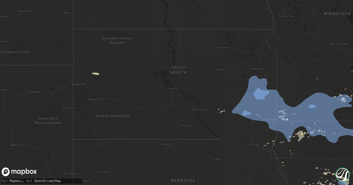
Hail Map in South Dakota on July 20, 2019
Get this storm
July 20 map
$229
one time, instant access
Download today. No call, no setup
Keep the $229
Bought the map and want the full workflow? Apply the entire $229 to a subscription within 7 days. None of it is wasted.
Every map, not just this one
This buys you this map. Subscription and you get every map we run, in the markets you choose from a few cities to whole states to nationwide. Plus real-time alerts the moment a storm fires.
Contact data
Name, contact info, occupancy, even credit band for addresses in the footprint. You go from where it hit to who to call.
Become the source they trust
Unlimited branding weather history reports on demand. You already have the documented answer ready for the property owner, and you are the one who showed up with it.
Property data and RoofTrace estimates
Pull up any address you have got, its value and the exact code rules for that jurisdiction, straight from One Click Code. Then RoofTrace estimates the squares, pitch, and roof value, priced the way you price.
Storm reports in South Dakota
South Dakota
| Date | Description |
|---|---|
| 07/20/20198:35 AM CDT | Maximum wind gust measured at the canton mesonet site... Site id k7g9. |
| 07/20/20198:20 AM CDT | Wind split a large maple tree. |
| 07/20/20198:16 AM CDT | Asos station kfsd sioux falls airport. |
| 07/20/20198:10 AM CDT | Peak wind gust recorded at the kmhe asos. |
| 07/20/20198:07 AM CDT | Corrects previous tstm wnd gst report from 3 nnw sioux falls. Asos station kfsd joe foss field. |
| 07/20/20197:59 AM CDT | At 1258 AM MDT, a severe thunderstorm was located 9 miles south of Isabel, or 16 miles north of Lantry, moving east at 60 mph. HAZARD...60 mph wind gusts and quarter size hail. SOURCE...Radar indicated. IMPACT...Hail damage to vehicles is expected. Expect wind damage to roofs, siding, and trees. Locations impacted include... Timber Lake, Isabel, Firesteel, Tiospaye Topa School, Little Moreau Rec Area, Promise, White Horse, Bear Creek, Green Grass, Laplant, Glencross and Ridgeview. |
| 07/20/20197:59 AM CDT | Sddot rwis site. |
| 07/20/20197:59 AM CDT | Sddot rwis site. |
| 07/20/20197:57 AM CDT | Estimated 60-70 mph. |
| 07/20/20197:54 AM CDT | Sddot rwis site. |
| 07/20/20197:38 AM CDT | Metal roof panels on small apartment building ripped off. Time estimated from radar. |
| 07/20/20197:37 AM CDT | At 1236 AM MDT, a severe thunderstorm was located 9 miles northeast of Owl Butte, or 33 miles northeast of Sturgis, moving east at 50 mph. HAZARD...60 mph wind gusts and quarter size hail. SOURCE...Radar indicated. IMPACT...Hail damage to vehicles is expected. Expect wind damage to roofs, siding, and trees. Locations impacted include... Plainview, Fairpoint, Marcus, Stoneville, White Owl, Opal, Red Owl and Owl Butte. |
| 07/20/20197:34 AM CDT | At 1234 AM MDT, a severe thunderstorm was located 5 miles south of Glad Valley, or 21 miles northwest of Dupree, moving east at 50 mph. HAZARD...Golf ball size hail and 60 mph wind gusts. SOURCE...Radar indicated. IMPACT...People and animals outdoors will be injured. Expect hail damage to roofs, siding, windows, and vehicles. Expect wind damage to roofs, siding, and trees. Locations impacted include... Thunder Butte and Glad Valley. |
| 07/20/20197:33 AM CDT | Awos station kbkx brookings municipal airport. |
| 07/20/20197:32 AM CDT | Heavy damage to grain elevator in town. Report relayed via twitter. Time estimated from radar. |
| 07/20/20197:31 AM CDT | A local report indicates 66 MPH wind near 4 S SALEM |
| 07/20/20197:26 AM CDT | At 1226 AM MDT, a severe thunderstorm was located near Mud Butte, or 40 miles west of Faith, moving east at 35 mph. HAZARD...60 mph wind gusts and half dollar size hail. SOURCE...Radar indicated. IMPACT...Hail damage to vehicles is expected. Expect wind damage to roofs, siding, and trees. Locations impacted include... Opal, Usta, Maurine, Mud Butte and Zeona. |
| 07/20/20197:23 AM CDT | Four boats lifted off their racks along the south shore of lake madison. Time estimated from radar. |
| 07/20/20197:19 AM CDT | Measured on home weather station. |
| 07/20/20197:16 AM CDT | Extensive tree damage in the town. A tree fell onto power lines near the transformer... Causing power outages. Time estimated from radar. |
| 07/20/20197:15 AM CDT | 5-6 inch diameter tree branches down in the town. |
| 07/20/20197:14 AM CDT | Sddot rwis site. |
| 07/20/20197:00 AM CDT | A local report indicates 60 MPH wind near 6 NNW PLANKINTON |
| 07/20/20194:02 AM CDT | At 902 AM CDT, severe thunderstorms were located along a line extending from near Fulda to near Little Rock to near Ireton, moving east at 45 mph. HAZARD...60 mph wind gusts. SOURCE...Radar indicated. IMPACT...Expect damage to roofs, siding, and trees. Severe thunderstorms will be near... Sibley and Little Rock around 905 AM CDT. Orange City, Ocheyedan and Brewster around 920 AM CDT. Alton, Heron Lake and Round Lake around 925 AM CDT. Hospers, Granville and Harris around 930 AM CDT. Lake Park around 935 AM CDT. Lakefield around 940 AM CDT. Spirit Lake, Jackson In Jackson County, Milford, Arnolds Park, Paullina, Bergen, Okoboji, Orleans, Wahpeton and West Okoboji around 945 AM CDT.Other locations impacted by these severe thunderstorms includeMoneta, Calumet, Rossie, Alpha, Kinbrae, Okabena, Bigelow and Wilder. |
| 07/20/20193:39 AM CDT | At 839 AM CDT, severe thunderstorms were located along a line extending from near Rock Rapids to near Beresford, moving east at 50 mph. HAZARD...70 mph wind gusts. SOURCE...Radar indicated. IMPACT...Expect considerable tree damage. Damage is likely to mobile homes, roofs, and outbuildings. Severe thunderstorms will be near... Rock Rapids around 845 AM CDT. Hawarden, George and Hudson around 855 AM CDT. Little Rock around 900 AM CDT. Ireton around 905 AM CDT. Sioux Center and Sibley around 910 AM CDT.Other locations impacted by these severe thunderstorms includeBigelow. |
| 07/20/20193:15 AM CDT | At 815 AM CDT, a severe thunderstorm was located over Tea, or 9 miles southwest of Sioux Falls, moving east at 45 mph. HAZARD...70 mph wind gusts. SOURCE...Radar indicated. IMPACT...Expect considerable tree damage. Damage is likely to mobile homes, roofs, and outbuildings. This severe thunderstorm will be near... Harrisburg around 825 AM CDT. Lake Alvin State Recreation Area around 830 AM CDT. Rowena around 835 AM CDT. Larchwood around 840 AM CDT. Inwood, Lester and Alvord around 845 AM CDT.Other locations impacted by this severe thunderstorm include Steen. |
| 07/20/20192:48 AM CDT | At 748 AM CDT, severe thunderstorms were located along a line extending from near Forestburg to near Mitchell to near Dimock, moving east at 40 mph. HAZARD...60 mph wind gusts. SOURCE...Radar indicated. IMPACT...Expect damage to roofs, siding, and trees. Severe thunderstorms will be near... Alexandria, Artesian and Fulton around 800 AM CDT. Milltown, Fedora and Farmer around 810 AM CDT. Spencer In McCook County and Roswell around 815 AM CDT. Clayton around 820 AM CDT. Vilas around 825 AM CDT. Howard, Bridgewater and Canova around 830 AM CDT. |
| 07/20/20191:52 AM CDT | At 652 AM CDT, severe thunderstorms were located along a line extending from near Gann Valley to near White Lake to 9 miles west of Aurora Center, moving east at 35 mph. HAZARD...60 mph wind gusts. SOURCE...Radar indicated. IMPACT...Expect damage to roofs, siding, and trees. Severe thunderstorms will be near... White Lake around 700 AM CDT. Aurora Center around 710 AM CDT. Plankinton, Wessington Springs and Stickney around 720 AM CDT. |
| 07/20/20191:44 AM CDT | At 643 AM CDT, severe thunderstorms were located along a line extending from near Grass Lake to near De Smet, moving east at 40 mph. HAZARD...60 mph wind gusts and nickel size hail. SOURCE...Trained weather spotters. IMPACT...Expect damage to roofs, siding, and trees. Locations impacted include... Watertown, Clear Lake, Estelline, Castlewood, Lake Norden, Bryant, Hayti, Florence, Rauville, Henry, South Shore, Waverly, Kranzburg, Goodwin, Stockholm, Hazel, Wallace, Strandburg, Twin Brooks and La Bolt. |
| 07/20/20191:36 AM CDT | At 636 AM CDT, severe thunderstorms were located along a line extending from 8 miles south of Willow Lake to 6 miles north of Artesian to near Plankinton, moving east at 40 mph. HAZARD...70 mph wind gusts and quarter size hail. SOURCE...Radar indicated. IMPACT...Hail damage to vehicles is expected. Expect considerable tree damage. Wind damage is also likely to mobile homes, roofs, and outbuildings. Severe thunderstorms will be near... Artesian around 640 AM CDT. De Smet around 645 AM CDT. Carthage and Fedora around 650 AM CDT. Roswell around 655 AM CDT. Mitchell, Lake Preston and Loomis around 700 AM CDT. Howard and Vilas around 705 AM CDT. Badger and Hetland around 710 AM CDT. Winfred and Fulton around 715 AM CDT.Other locations impacted by these severe thunderstorms includeBancroft and Erwin. |
| 07/20/20191:29 AM CDT | At 628 AM CDT, a severe thunderstorm was located near Etbauer Hill, or 10 miles east of Fort Thompson, moving east at 40 mph. HAZARD...60 mph wind gusts. SOURCE...Radar indicated. IMPACT...Expect damage to roofs, siding, and trees. Locations impacted include... Shelby, Gann Valley, Lees Corner, Crow Creek Housing and Etbauer Hill. |
| 07/20/20191:22 AM CDT | At 621 AM CDT, severe thunderstorms were located along a line extending from near Crocker to 6 miles east of Yale, moving east at 40 mph. HAZARD...70 mph wind gusts and quarter size hail. SOURCE...Radar indicated. IMPACT...Hail damage to vehicles is expected. Expect considerable tree damage. Wind damage is also likely to mobile homes, roofs, and outbuildings. Locations impacted include... Clark, Bryant, Florence, Henry, Willow Lake, Hazel, Wallace, Bradley, Garden City, Vienna, Naples, Lily, Crocker, Medicine Lake, Mayfield Colony, Grass Lake, Kellerton Church, Swan Lake, Hillcrest Colony and Bitter Lake. |
| 07/20/201912:55 AM CDT | At 555 AM CDT, severe thunderstorms were located along a line extending from 7 miles west of Carpenter to near Alpena to 8 miles east of Chamberlain, moving east at 35 mph. HAZARD...60 mph wind gusts and penny size hail. SOURCE...Radar indicated. IMPACT...Expect damage to roofs, siding, and trees. Severe thunderstorms will be near... Alpena around 600 AM CDT. White Lake around 630 AM CDT. Plankinton and Carthage around 645 AM CDT.Other locations impacted by these severe thunderstorms includeBancroft, Broadland and Pukwana. |
| 07/20/201912:53 AM CDT | At 551 AM CDT, severe thunderstorms were located along a line extending from near Turton to near Hitchcock, moving east at 40 mph. HAZARD...60 mph wind gusts and quarter size hail. SOURCE...Radar indicated. IMPACT...Hail damage to vehicles is expected. Expect wind damage to roofs, siding, and trees. Locations impacted include... Clark, Willow Lake, Doland, Frankfort, Garden City, Raymond, Turton, Clark Colony, Spink Colony, Glendale Colony, Fordham Colony, Hillcrest Colony, Hillside Colony and Carpenter. |
| 07/20/201912:36 AM CDT | At 535 AM CDT, severe thunderstorms were located along a line extending from near Gann Valley to near Oacoma, moving east at 40 mph. HAZARD...60 mph wind gusts and penny size hail. SOURCE...Radar indicated. IMPACT...Expect damage to roofs, siding, and trees. These severe thunderstorms will remain over mainly rural areas of southwestern Jerauld and northern Brule Counties, including the following locations... Pukwana. |
| 07/20/201912:32 AM CDT | At 531 AM CDT, severe thunderstorms were located along a line extending from near Lake Sharpe to 11 miles southwest of 5 Mile Corner, moving east at 40 mph. HAZARD...60 mph wind gusts. SOURCE...Radar indicated. IMPACT...Expect damage to roofs, siding, and trees. Locations impacted include... Lower Brule, Presho, Fort Thompson, Lyman, Oacoma, Kennebec, Reliance, Vivian, Shelby, Cedar Creek Rec Area, Fate Dam, Medicine Butte, Earling Hills, Dude Ranch, Etbauer Hill, Lake Sharpe, Gann Valley, Lees Corner, Degrey Rec Area and West Bend Rec Area. |
| 07/20/201912:23 AM CDT | At 523 AM CDT, severe thunderstorms were located along a line extending from near Tulare to near Etbauer Hill, moving east at 40 mph. HAZARD...60 mph wind gusts and penny size hail. SOURCE...Radar indicated. IMPACT...Expect damage to roofs, siding, and trees. Severe thunderstorms will be near... Hitchcock around 540 AM CDT.Other locations impacted by these severe thunderstorms includeBroadland. |
| 07/20/201912:22 AM CDT | At 522 AM CDT, severe thunderstorms were located along a line extending from near Athol to 9 miles west of Pleasant Valley Country Church, moving east at 40 mph. HAZARD...60 mph wind gusts and quarter size hail. SOURCE...Radar indicated. IMPACT...Hail damage to vehicles is expected. Expect wind damage to roofs, siding, and trees. Locations impacted include... Redfield, Miller, Mellette, Tulare, St. Lawrence, Doland, Frankfort, Northville, Conde, Ashton, Hitchcock, Brentford, Athol, Burdette, Turton, Vayland, Rosehill Dam, Miller Dale Colony, Cottonwood Lake and Sunshine Bible Academy. |
| 07/19/201911:34 PM CDT | At 433 AM CDT/333 AM MDT/, severe thunderstorms were located along a line extending from 7 miles northeast of Holabird to near Harrold to near Degrey Rec Area to 9 miles north of Vivian to near Okaton, moving east at 30 mph. HAZARD...60 mph wind gusts and penny size hail. SOURCE...Radar indicated. IMPACT...Expect damage to roofs, siding, and trees. Locations impacted include... Lower Brule, Highmore, Presho, Murdo, Blunt, Vivian, Harrold, Draper, Ree Heights, Okaton, Westover, Cedar Creek Rec Area, Fate Dam, Rousseau, Joe Creek Rec Area, Canning, Holabird, Stephan, 5 Mile Corner and Lake Sharpe. |
| 07/19/201910:57 PM CDT | At 357 AM CDT, a severe thunderstorm was located over Cottonwood Lake Near Agar, or 10 miles northeast of Onida, moving east at 50 mph. HAZARD...60 mph wind gusts and penny size hail. SOURCE...Radar indicated. IMPACT...Expect damage to roofs, siding, and trees. Locations impacted include... Onida, Orient, Stone Lake and Cottonwood Lake Near Agar. |
| 07/19/201910:52 PM CDT | At 352 AM CDT, a severe thunderstorm was located over Lebanon, or 9 miles northeast of Gettysburg, moving east at 50 mph. HAZARD...60 mph wind gusts and penny size hail. SOURCE...Radar indicated. IMPACT...Expect damage to roofs, siding, and trees. Locations impacted include... Faulkton, Orient, Lebanon, Seneca, Tolstoy, Onaka, Burkmere, Brentwood Colony and Norbeck. |
| 07/19/201910:46 PM CDT | At 343 AM MDT, a severe thunderstorm was located 3 miles southeast of Howes, or 29 miles south of Faith, moving east at 50 mph. HAZARD...60 mph wind gusts and quarter size hail. SOURCE...Radar indicated. IMPACT...Hail damage to vehicles is expected. Expect wind damage to roofs, siding, and trees. Locations impacted include... Cherry Creek, Milesville, Bridger, Kirley, Howes, Billsburg and Takini School. |
| 07/19/20199:43 PM CDT | At 243 AM CDT/143 AM MDT/, a severe thunderstorm was located near Ridgeview, or 21 miles northeast of Eagle Butte, moving east at 50 mph. HAZARD...60 mph wind gusts and quarter size hail. SOURCE...Radar indicated. IMPACT...Hail damage to vehicles is expected. Expect wind damage to roofs, siding, and trees. Locations impacted include... Gettysburg, Lowry, Tiospaye Topa School, Swiftbird Day School, Swan Creek Rec Area, Swiftbird, Whitlocks Bay Rec Area, Laplant, Ridgeview and Lake Oahe. |
| 07/19/20199:36 PM CDT | At 235 AM CDT/135 AM MDT/, a severe thunderstorm was located 7 miles east of Tiospaye Topa School, or 25 miles south of Mobridge, moving east at 50 mph. HAZARD...60 mph wind gusts and quarter size hail. SOURCE...Radar indicated. IMPACT...Hail damage to vehicles is expected. Expect wind damage to roofs, siding, and trees. Locations impacted include... Hoven, Lebanon and Lake Oahe. |
| 07/19/20198:28 PM CDT | At 127 AM MDT, a severe thunderstorm was located 8 miles southeast of Durkee Lake, or 10 miles southeast of Faith, moving east at 40 mph. HAZARD...60 mph wind gusts and quarter size hail. SOURCE...Radar indicated. IMPACT...Hail damage to vehicles is expected. Expect wind damage to roofs, siding, and trees. Locations impacted include... Dupree, Faith, Cherry Creek, Milesville, Plainview, Enning, Opal, Marcus, South Eagle Butte, Bridger, Kirley, Howes, White Owl, Red Scaffold, Billsburg, Red Owl, Red Elm, Intersection of Cherry Creek and Sunnybrook Roads, Intersection of Highway 63 and BIA Road 8 and Durkee Lake. |
| 07/19/20198:09 PM CDT | At 109 AM MDT, a severe thunderstorm was located 3 miles south of Iron Lightning, or 11 miles northeast of Faith, moving east at 45 mph. HAZARD...60 mph wind gusts and quarter size hail. SOURCE...Radar indicated. IMPACT...Hail damage to vehicles is expected. Expect wind damage to roofs, siding, and trees. Locations impacted include... Dupree, Faith, Thunder Butte, Red Elm, Iron Lightning, Durkee Lake and Arrow Head Buttes. |
All States Impacted by Hail Map on July 20, 2019
Cities Impacted by Hail Map on July 20, 2019
- Moulton, IA
- Jamestown, CO
- Longmont, CO
- Boulder, CO
- Ward, CO
- Rose Hill, IA
- Hedrick, IA
- Sigourney, IA
- Delta, IA
- Colorado Springs, CO
- Idalia, CO
- McCool Junction, NE
- Fairmont, NE
- York, NE
- Henderson, NE
- Centerville, IA
- Udell, IA
- Princeton, MO
- Spickard, MO
- Jackman, ME
- Graettinger, IA
- Emmetsburg, IA
- Pulaski, IA
- Stinnett, KY
- Hyden, KY
- Arcadia, WI
- Holcomb, KS
- Garden City, KS
- Sully, IA
- Lynnville, IA
- Granite Falls, NC
- Hudson, NC
- Leoti, KS
- Bonduel, WI
- Amherst, WI
- Churdan, IA
- Jefferson, IA
- Ralston, IA
- Glidden, IA
- Scranton, IA
- Berryville, VA
- Boyce, VA
- Bluemont, VA
- Front Royal, VA
- Sublette, KS
- Satanta, KS
- Venus, PA
- Brookfield, MO
- Chariton, IA
- Russell, IA
- Sedalia, CO
- Divide, CO
- Pueblo, CO
- New London, WI
- Bear Creek, WI
- Rockville, NE
- Boelus, NE
- Denver, CO
- Morrison, CO
- Golden, CO
- Sanderson, FL
- Alzada, MT
- Cheyenne, WY
- Montrose, SD
- Canistota, SD
- Archer, IA
- Sheldon, IA
- Hartley, IA
- Sutherland, IA
- Primghar, IA
- Sanborn, IA
- Paullina, IA
- Gayville, SD
- Burlington, CO
- Kirk, CO
- Letcher, KY
- Blackey, KY
- Cornettsville, KY
- Carsonville, MI
- Davis City, IA
- Leon, IA
- Decatur, IA
- Cannon Falls, MN
- Kenyon, MN
- Dennison, MN
- Woodward, IA
- Dannebrog, NE
- Grand Island, NE
- Cairo, NE
- Saint Libory, NE
- Oconto, NE
- Ansley, NE
- Clifford, MI
- Mayville, MI
- Silverwood, MI
- La Junta, CO
- Saint Joseph, MO
- Cosby, MO
- Savannah, MO
- Prairie City, IA
- Runnells, IA
- Custer, MI
- Chase, MI
- Branch, MI
- Baldwin, MI
- Scottville, MI
- Big Rapids, MI
- Free Soil, MI
- Irons, MI
- Hersey, MI
- Rodney, MI
- Paris, MI
- Idlewild, MI
- Bitely, MI
- Luther, MI
- Reed City, MI
- Ludington, MI
- Fountain, MI
- Indianola, IA
- Guilford, MO
- Larkspur, CO
- Monument, CO
- Las Animas, CO
- New Hampton, MO
- McFall, MO
- Bethany, MO
- Lamar, CO
- Granada, CO
- Holly, CO
- Northville, MI
- Howe, IN
- Stratton, CO
- Yoder, CO
- Chili, WI
- Marshfield, WI
- Millville, MN
- Mazeppa, MN
- Oronoco, MN
- West Concord, MN
- Rochester, MN
- Pine Island, MN
- Zumbro Falls, MN
- Zumbrota, MN
- Elgin, MN
- Lexington, NE
- Cleveland, OH
- Lucas, IA
- Lacona, IA
- Lovilia, IA
- Melrose, IA
- Albia, IA
- Greenville, ME
- Vona, CO
- Weston, WY
- Brady, NE
- Hayes Center, NE
- Lafayette, CO
- Olney Springs, CO
- Sugar City, CO
- Ordway, CO
- Rock River, WY
- Whitley City, KY
- Palm Harbor, FL
- Mineral Point, WI
- Darlington, WI
- Barrington, IL
- Casco, WI
- Luxemburg, WI
- Milford, IA
- Weldon, IA
- Apex, NC
- Cary, NC
- Bear Creek, NC
- Sanford, NC
- Magnolia, MN
- Luverne, MN
- Cozad, NE
- Rea, MO
- Rosendale, MO
- Bolckow, MO
- New Port Richey, FL
- Monroe, IA
- Beaver Crossing, NE
- Mankato, MN
- Benkelman, NE
- Seibert, CO
- Wyaconda, MO
- Auburndale, WI
- Hewitt, WI
- Edgerton, MN
- Barnard, MO
- Conception Junction, MO
- Kit Carson, CO
- Grenville, NM
- Dunnellon, FL
- Taylorsville, NC
- Black River Falls, WI
- Sparta, WI
- Tomah, WI
- Warrens, WI
- Eads, CO
- Dunbar, NE
- Maitland, MO
- Skidmore, MO
- Floris, IA
- Bloomfield, IA
- Hamburg, IA
- Branson, CO
- Model, CO
- New Sharon, IA
- Adrian, MN
- Manlius, NY
- Cazenovia, NY
- Oregon, MO
- Fillmore, MO
- Winston, MO
- Weatherby, MO
- Leroy, MI
- Juda, WI
- Brodhead, WI
- Liberal, KS
- Wray, CO
- Saint Francis, KS
- Clearmont, WY
- Arvada, WY
- Green Bay, WI
- Moorefield, NE
- Cainsville, MO
- Winston Salem, NC
- Faribault, MN
- Reeseville, WI
- Columbus, WI
- Perry, IA
- Pleasantville, IA
- Knoxville, IA
- Pattonsburg, MO
- Salix, IA
- Pulaski, WI
- Amsterdam, NY
- Pattersonville, NY
- North Bloomfield, OH
- Orwell, OH
- Empire, MI
- Dodgeville, WI
- Barneveld, WI
- Ridgeway, WI
- Elkhorn, WI
- Fremont, IA
- Oskaloosa, IA
- Valparaiso, NE
- Baring, MO
- Grainfield, KS
- Sarasota, FL
- Spirit Lake, IA
- Mosinee, WI
- Pleasant Dale, NE
- Hillsboro, IA
- Saint Petersburg, FL
- Steen, MN
- Kanaranzi, MN
- Ellsworth, MN
- Plainview, MN
- Marienthal, KS
- Granton, WI
- Pittsville, WI
- Norwalk, IA
- Callaway, NE
- Unionville, MO
- Green Castle, MO
- Newell, SD
- Eleva, WI
- Mondovi, WI
- Mitchellville, IA
- Swan, IA
- Searsboro, IA
- Reasnor, IA
- Otley, IA
- Altoona, IA
- Pella, IA
- Melcher Dallas, IA
- Traverse City, MI
- Lake Ann, MI
- Irwin, IA
- Kirkman, IA
- Elsie, NE
- Tribune, KS
- Broken Bow, NE
- Novinger, MO
- Worthington, MO
- Nebraska City, NE
- Hasty, CO
- Eagle Lake, MN
- Madison Lake, MN
- Guthrie Center, IA
- Imperial, NE
- Advance, NC
- Oregon, WI
- Stoughton, WI
- Boone, CO
- Altamont, MO
- Avondale, CO
- Plover, WI
- Junction City, WI
- Stevens Point, WI
- North Platte, NE
- Watertown, WI
- Blair, WI
- Ettrick, WI
- Lake Zurich, IL
- Mundelein, IL
- Union Star, MO
- Clarksdale, MO
- Amity, MO
- King City, MO
- Fox River Grove, IL
- Algonquin, IL
- Dundee, IL
- Cary, IL
- Carpentersville, IL
- Greenville Junction, ME
- Rockwood, ME
- Maysville, MO
- Watson, MO
- Peru, NE
- Brownville, NE
- Rock Port, MO
- Coon Rapids, IA
- Audubon, IA
- Edgerton, WI
- Evansville, WI
- Windsor, OH
- Middlefield, OH
- Vicco, KY
- Sassafras, KY
- Viper, KY
- Isom, KY
- Scuddy, KY
- Redfox, KY
- Roxana, KY
- Jeremiah, KY
- Whitesburg, KY
- North Port, FL
- Fort Myers, FL
- Thomasville, NC
- Lake Geneva, WI
- Springfield, WI
- Burlington, WI
- Trinidad, CO
- Rosholt, WI
- Hatley, WI
- Hesperia, MI
- Lexington, NC
- Milwaukee, WI
- Oak Creek, WI
- Franklin, WI
- Waterloo, WI
- Jamaica, IA
- Gates Mills, OH
- Chesterland, OH
- Branchville, NJ
- Mason City, NE
- Lineville, IA
- Byron, MN
- White Post, VA
- Spencer, IA
- Skaneateles, NY
- Auburn, NY
- Claremont, MN
- Oxford, MI
- New Era, MI
- Cochrane, WI
- Newton, IA
- Helena, MO
- Milo, IA
- Granger, IA
- Madrid, IA
- Janesville, MN
- Farmington, MI
- Williamson, IA
- London, KY
- Kellogg, IA
- Downing, MO
- Memphis, MO
- Volga, SD
- Bremen, IN
- Algoma, WI
- Niobrara, NE
- Fairfield, IA
- New Boston, MO
- Darlington, MO
- Albany, MO
- Lake Crystal, MN
- Janesville, WI
- Rocky Ford, CO
- Tampa, FL
- Kilkenny, MN
- Montgomery, MN
- South Wayne, WI
- Monticello, NY
- Vowinckel, PA
- Lucinda, PA
- Marble, PA
- Lickingville, PA
- Fryburg, PA
- Leeper, PA
- Shippenville, PA
- Cooksburg, PA
- Murfreesboro, TN
- Smyrna, TN
- Gainesville, FL
- Oneida, NY
- Oneill, NE
- Sumner, NE
- Luray, MO
- Arbela, MO
- Knox City, MO
- Gorin, MO
- La Belle, MO
- Rutledge, MO
- Oneida, WI
- Seymour, WI
- Ogdensburg, WI
- New Franken, WI
- Hardwick, MN
- Camden, NY
- Taberg, NY
- Blossvale, NY
- Everly, IA
- Maywood, NE
- Westboro, MO
- Tarkio, MO
- Fairfax, MO
- Lake City, IA
- Lohrville, IA
- Stratton, NE
- Browning, MO
- Humphreys, MO
- Gillette, WY
- De Pere, WI
- Monroe, WI
- Milan, MO
- Deckerville, MI
- Sandusky, MI
- Port Sanilac, MI
- Brooksville, FL
- Hanna, WY
- Medicine Bow, WY
- Fountain City, WI
- Scott City, KS
- Marion, SD
- Corydon, IA
- Rudd, IA
- Hospers, IA
- Orange City, IA
- Carroll, IA
- Monticello, KY
- Bronston, KY
- Lake George, CO
- Estes Park, CO
- Cape Coral, FL
- Randolph, MN
- Royal, IA
- Dedham, IA
- Culbertson, NE
- Prole, IA
- Wood River, NE
- Burlington Junction, MO
- Promise City, IA
- Seymour, IA
- Athens, PA
- Powersville, MO
- Hart, MI
- Rome, NY
- Sheridan Lake, CO
- Gilman City, MO
- Rothbury, MI
- Stanberry, MO
- Conception, MO
- Deerfield, IL
- Lake Forest, IL
- Libertyville, IL
- Vernon Hills, IL
- Lincolnshire, IL
- Woodland Park, CO
- Green Mountain Falls, CO
- Oneida, TN
- Taylor, WI
- Whitehall, WI
- Melrose, WI
- Independence, WI
- Dodge, WI
- Galesville, WI
- Union, NE
- Percival, IA
- Elk Point, SD
- Eldon, IA
- Agency, IA
- Ottumwa, IA
- Maxwell, NE
- Miller, NE
- Stewartville, MN
- Lake Butler, FL
- Brooker, FL
- Boyd, WI
- Custer, WI
- Redfield, IA
- Earlham, IA
- Fremont, OH
- Pittsboro, NC
- Fostoria, OH
- Kansas, OH
- Columbia, IA
- Hamilton, IA
- Green City, MO
- Maiden Rock, WI
- Humboldt, SD
- Gruver, TX
- Ocala, FL
- Eddyville, NE
- Wallace, NE
- Bosler, WY
- Red Wing, MN
- Waco, NE
- Van Wert, IA
- Garden Grove, IA
- Newtown, MO
- Lucerne, MO
- New Virginia, IA
- Mocksville, NC
- Lyons, CO
- Leighton, IA
- Champion, NE
- Saint Peter, MN
- Cleveland, MN
- Morristown, MN
- Waterville, MN
- Gothenburg, NE
- La Plata, MO
- Kirksville, MO
- Gibbs, MO
- Casey, IA
- Bagley, IA
- Yale, IA
- Stuart, IA
- Panora, IA
- Bayard, IA
- Menlo, IA
- Dexter, IA
- Overton, NE
- Arlington, CO
- Somerset, KY
- Swink, CO
- Shelby, MI
- White Cloud, MI
- Walkerville, MI
- Montague, MI
- Glenrock, WY
- Gallatin, TN
- Milladore, WI
- Altura, MN
- Mantorville, MN
- Eyota, MN
- Kasson, MN
- Kellogg, MN
- Dodge Center, MN
- Arkdale, WI
- Saint Charles, MI
- Haswell, CO
- Cookeville, TN
- Thurman, IA
- Sidney, IA
- Boyceville, WI
- Menomonie, WI
- Lena, IL
- Marion, WI
- Oriskany Falls, NY
- Goldston, NC
- Trinity, NC
- Parrish, FL
- Union Center, SD
- Clearmont, MO
- Scandinavia, WI
- Clintonville, WI
- Waupaca, WI
- Tigerton, WI
- Iola, WI
- Manawa, WI
- Weyauwega, WI
- Greentop, MO
- Brashear, MO
- Sibley, IA
- Little Rock, IA
- Humeston, IA
- Woodburn, IA
- Derby, IA
- Marquette, NE
- Lonsdale, MN
- Troy, NY
- Murray, NE
- Weskan, KS
- White Lake, SD
- Madison, WI
- Ridgeway, MO
- Bay City, WI
- Winona, KS
- Rickman, TN
- Livingston, TN
- Jasper, MN
- Colfax, IA
- Amazonia, MO
- Allardt, TN
- Sunbright, TN
- Trempealeau, WI
- Saginaw, MI
- Shawano, WI
- Slemp, KY
- Black Creek, WI
- Bird Island, MN
- Olivia, MN
- Franklin, MN
- Goodhue, MN
- Le Center, MN
- Maryville, MO
- Boscobel, WI
- Fennimore, WI
- High Point, NC
- Statesville, NC
- Oconomowoc, WI
- Ixonia, WI
- Newbury, OH
- Pentwater, MI
- Breckenridge, MO
- Spring Hill, FL
- Osmond, NE
- Hazard, NE
- Litchfield, NE
- Seward, NE
- McCook, NE
- Littleton, CO
- Chestnut Mound, TN
- Baxter, TN
- Buffalo Valley, TN
- Silver Point, TN
- Kewaunee, WI
- Sloan, IA
- Hiddenite, NC
- Stony Point, NC
- Mount Ayr, IA
- Morriston, FL
- Fall Creek, WI
- Defiance, IA
- Earling, IA
- Burton, OH
- Clarinda, IA
- Arcadia, FL
- Remsen, IA
- Randleman, NC
- Livonia, MO
- Maurice, IA
- Gallatin, MO
- Wisconsin Rapids, WI
- Vesper, WI
- Wellfleet, NE
- Bloomer, WI
- Chippewa Falls, WI
- Camp Douglas, WI
- Manzanola, CO
- Madison, NY
- Bradenton, FL
- Ogden, IA
- Verona, WI
- Elkhorn City, KY
- Reddick, FL
- Galt, MO
- Elroy, WI
- Mauston, WI
- Osceola, IA
- Venice, FL
- Lancaster, WI
- Albany, WI
- Tracy, IA
- Bussey, IA
- Parks, NE
- Mount Juliet, TN
- Gower, MO
- Stewartsville, MO
- Plattsburg, MO
- Trimble, MO
- Manning, IA
- Conneaut Lake, PA
- Cameron, MO
- Hamilton, MO
- Adair, IA
- Grafton, NE
- Myakka City, FL
- Breda, IA
- Shelton, NE
- Sophia, NC
- North Branch, MI
- Fostoria, MI
- Terril, IA
- Dickens, IA
- Le Mars, IA
- Ireton, IA
- Vermillion, SD
- Amherst Junction, WI
- Bentonville, VA
- Nerstrand, MN
- Plankinton, SD
- Asheboro, NC
- Cheyenne Wells, CO
- Wildwood, FL
- Oxford, FL
- Hickman, TN
- Hilliard, FL
- Callahan, FL
- Good Thunder, MN
- Constantia, NY
- West Monroe, NY
- Glen Arbor, MI
- Ruthven, IA
- Estherville, IA
- Olin, NC
- Union Grove, NC
- West Farmington, OH
- Snover, MI
- Palms, MI
- Homosassa, FL
- Lecanto, FL
- Kendall, WI
- Syracuse, NY
- Nedrow, NY
- Marietta, NY
- Harmony, NC
- Queen City, MO
- Highland, WI
- Montfort, WI
- Muscoda, WI
- Clairfield, TN
- Deerfield, KS
- Alachua, FL
- Wesley, IA
- Kingsley, IA
- Amherst, NE
- Pleasanton, NE
- Franklinton, NC
- Plano, IA
- Trenton, MO
- Jameson, MO
- Kidder, MO
- Texhoma, OK
- Fonda, NY
- Fultonville, NY
- Fort Hunter, NY
- Beaver Creek, MN
- Algona, IA
- Jones, MI
- Laredo, MO
- Kenton, OK
- Linneus, MO
- Purdin, MO
- Beresford, SD
- Burbank, SD
- Solon, OH
- Bedford, OH
- Chagrin Falls, OH
- Micanopy, FL
- Deer Lodge, TN
- Blythedale, MO
- Eagleville, MO
- Aurora, NE
- Pine Knot, KY
- Strunk, KY
- Revelo, KY
- Marlette, MI
- Summerfield, FL
- Marathon, WI
- Manitou Springs, CO
- McClave, CO
- Beloit, WI
- Perryton, TX
- Arlington Heights, IL
- Wheeling, IL
- Palatine, IL
- Pollock, MO
- Guymon, OK
- Ledger, MT
- Conrad, MT
- Buchanan, MI
- Galien, MI
- Rudolph, WI
- Middletown, VA
- Manistee, MI
- Ackworth, IA
- Liberty Center, IA
- Morganton, NC
- Egg Harbor, WI
- Ollie, IA
- Packwood, IA
- Barre, VT
- Montpelier, VT
- Bee, NE
- Mercer, MO
- Burt, IA
- Denmark, WI
- Unity, WI
- Spencer, WI
- Stratford, WI
- Colby, WI
- Pickering, MO
- Alcester, SD
- Chardon, OH
- New Hampton, IA
- Green Isle, MN
- Bradshaw, NE
- Naples, FL
- Stockville, NE
- Lebanon, TN
- Arpin, WI
- Welch, MN
- Mapleton, MN
- Necedah, WI
- Rushmore, MN
- Blanchardville, WI
- Hollandale, WI
- Hickory, NC
- Cobb, WI
- Braddyville, IA
- Elmo, MO
- Jamesport, MO
- Alton, IA
- Granville, IA
- Dallas Center, IA
- Polk City, IA
- Rippey, IA
- Bouton, IA
- Grand Junction, IA
- Le Roy, MN
- Reese, MI
- Old Town, FL
- Dawson, IA
- Ridott, IL
- Pecatonica, IL
- Batavia, IA
- Wiley, CO
- Hudson, FL
- Parkers Lake, KY
- Elizabeth, IL
- Savanna, IL
- Kellerton, IA
- Hatfield, MO
- Forestville, WI
- Villisca, IA
- Cumberland, IA
- Murdock, NE
- Weeping Water, NE
- Cascade, CO
- Peyton, CO
- Calhan, CO
- Albany, NY
- Berlin, NY
- Stephentown, NY
- Palatine Bridge, NY
- Marcy, NY
- Petersburg, NY
- Schenectady, NY
- Nelliston, NY
- Latham, NY
- Ilion, NY
- Tribes Hill, NY
- Fort Johnson, NY
- New Hartford, NY
- Johnstown, NY
- Yorkville, NY
- Frankfort, NY
- Clifton Park, NY
- Utica, NY
- Wynantskill, NY
- Rotterdam Junction, NY
- Alplaus, NY
- Oriskany, NY
- Cohoes, NY
- Whitesboro, NY
- Mohawk, NY
- Sand Lake, NY
- Little Falls, NY
- Westmoreland, NY
- Lanesborough, MA
- Watervliet, NY
- Fort Plain, NY
- Herkimer, NY
- New York Mills, NY
- Williamstown, MA
- Hagaman, NY
- Averill Park, NY
- Rexford, NY
- Poestenkill, NY
- Saint Johnsville, NY
- Barnes City, IA
- Pleasant Hill, IA
- Johnston, IA
- Blakesburg, IA
- Hartford, IA
- Richland, IA
- Bondurant, IA
- Ankeny, IA
- Clive, IA
- What Cheer, IA
- Beacon, IA
- Urbandale, IA
- Minburn, IA
- Berwick, IA
- Hayesville, IA
- University Park, IA
- Windsor Heights, IA
- Kirkville, IA
- Martinsburg, IA
- Harvey, IA
- Carlisle, IA
- Waukee, IA
- Eddyville, IA
- West Des Moines, IA
- Des Moines, IA
- Cedar, IA
- Adel, IA
- Grimes, IA
- Elkhart, IA
- Chillicothe, IA
- Lenoir, NC
- Estelline, SD
- Lake Benton, MN
- Swea City, IA
- Aurora, SD
- Oldham, SD
- Colman, SD
- Mountain Lake, MN
- Fairmont, MN
- Iona, MN
- Worthing, SD
- Woodstock, MN
- Harrisburg, SD
- Lake Preston, SD
- Canton, SD
- Ledyard, IA
- Britt, IA
- Arnolds Park, IA
- Welcome, MN
- Brandon, SD
- Madelia, MN
- Trimont, MN
- Avoca, MN
- Doon, IA
- Wentworth, SD
- Crystal Lake, IA
- Pemberton, MN
- Nunda, SD
- Egan, SD
- Castlewood, SD
- Colton, SD
- Howard, SD
- Garretson, SD
- Renner, SD
- Odin, MN
- Minnesota Lake, MN
- Saint Clair, MN
- Jeffers, MN
- Artesian, SD
- Ventura, IA
- Lester, IA
- Granada, MN
- Lakota, IA
- Brookings, SD
- Livermore, IA
- Sinai, SD
- Ashton, IA
- George, IA
- Parker, SD
- Butterfield, MN
- Sanborn, MN
- Dell Rapids, SD
- Salem, SD
- Hayti, SD
- Winnebago, MN
- Fulton, SD
- Fertile, IA
- Rock Rapids, IA
- New Richland, MN
- Elmore, MN
- Springfield, MN
- Garner, IA
- Whittemore, IA
- Waldorf, MN
- Elkton, SD
- Windom, MN
- Monroe, SD
- Madison, SD
- Okoboji, IA
- Saint James, MN
- Amboy, MN
- Fostoria, IA
- Bryant, SD
- Reading, MN
- Mason City, IA
- Rockwell, IA
- Tea, SD
- Jackson, MN
- Letcher, SD
- Okabena, MN
- Cylinder, IA
- Bridgewater, SD
- Canova, SD
- De Smet, SD
- Lewisville, MN
- Winfred, SD
- Melvin, IA
- Lamberton, MN
- Alvord, IA
- Truman, MN
- Hartford, SD
- Hull, IA
- Crooks, SD
- Rutland, SD
- Sleepy Eye, MN
- Larchwood, IA
- New Ulm, MN
- Trent, SD
- Hanska, MN
- Alpha, MN
- Round Lake, MN
- Pipestone, MN
- Ocheyedan, IA
- Darfur, MN
- Valley Springs, SD
- Bingham Lake, MN
- Comfrey, MN
- Heron Lake, MN
- Flandreau, SD
- Alexandria, SD
- Carthage, SD
- Holland, MN
- Bode, IA
- Kenneth, MN
- Wilmont, MN
- Baltic, SD
- West Bend, IA
- Clear Lake, IA
- Lu Verne, IA
- Waseca, MN
- Ruthton, MN
- Boyden, IA
- Blue Earth, MN
- Dunnell, MN
- Vernon Center, MN
- Brewster, MN
- Titonka, IA
- Ramona, SD
- Chancellor, SD
- Chandler, MN
- Storden, MN
- White, SD
- Ormsby, MN
- Matlock, IA
- Fedora, SD
- Dolliver, IA
- Fenton, IA
- Ottosen, IA
- Bruce, SD
- Lone Rock, IA
- Worthington, MN
- Woden, IA
- Lake Norden, SD
- Lake Park, IA
- Buffalo Center, IA
- Forest City, IA
- Hills, MN
- Leota, MN
- Lakefield, MN
- Ringsted, IA
- Lismore, MN
- Harris, IA
- Emery, SD
- Fulda, MN
- Lyons, SD
- Sioux Falls, SD
- Spencer, SD
- Rock Valley, IA
- Chester, SD
- Inwood, IA
- Badger, SD
- Bigelow, MN
- Mitchell, SD
- Sherburn, MN
- Armstrong, IA
- Arlington, SD
- Garden City, MN
- Bancroft, IA
- Westbrook, MN
- Superior, IA
- Ceylon, MN
- Sioux Center, IA
- Wallingford, IA
- Erwin, SD
- Albert Lea, MN
- Lansing, MN
- Brownsdale, MN
- Austin, MN
- Hayward, MN
- Waltham, MN
- Hollandale, MN
- Rose Creek, MN
- Winona, MN
- Saint Charles, MN
- Chatfield, MN
- Bangor, WI
- West Salem, WI
- Rockland, WI
- Racine, MN
- Alma, WI
- Dover, MN
- Minnesota City, MN
- Holmen, WI
- Mindoro, WI
- Osseo, MN
- Minneapolis, MN
- Forest Junction, WI
- Maribel, WI
- Pine River, WI
- Hixton, WI
- Cecil, WI
- Nichols, WI
- Sherwood, WI
- Babcock, WI
- Edgar, WI
- Kaukauna, WI
- Menasha, WI
- Greenleaf, WI
- Little Chute, WI
- Friendship, WI
- Hortonville, WI
- Humbird, WI
- Wautoma, WI
- Suamico, WI
- Two Rivers, WI
- Appleton, WI
- Larsen, WI
- Manitowoc, WI
- Greenville, WI
- Embarrass, WI
- Neenah, WI
- Wrightstown, WI
- Francis Creek, WI
- Shiocton, WI
- Greenwood, WI
- Neillsville, WI
- Bancroft, WI
- Loyal, WI
- Hilbert, WI
- Whitelaw, WI
- Combined Locks, WI
- Plainfield, WI
- Brillion, WI
- Almond, WI
- Wittenberg, WI
- Reedsville, WI
- Nekoosa, WI
- Port Edwards, WI
- Alma Center, WI
- Fremont, WI
- Winneconne, WI
- Mishicot, WI
- Hancock, WI
- Eland, WI
- Kimberly, WI
- Oshkosh, WI
- Nelsonville, WI
- Merrillan, WI
- Wild Rose, WI
- Saint Paul, MN
- Benzonia, MI
- Buckley, MI
- Honor, MI
- Thompsonville, MI
- Grawn, MI
- Kingsley, MI
- Beulah, MI
- Interlochen, MI
- Frankfort, MI
- Brohman, MI
- Frankenmuth, MI
- Munger, MI
- Carrollton, MI
- Fenton, MI
- Davisburg, MI
- Linden, MI
- Holly, MI
- Royal Oak, MI
- Pleasant Ridge, MI
- Oak Park, MI
- Redford, MI
- Highland Park, MI
- Novi, MI
- Southfield, MI
- Ferndale, MI
- Detroit, MI
- Livonia, MI
- Huntington Woods, MI
- Hazel Park, MI
- Fowler, CO
- Crowley, CO
- Cheraw, CO


