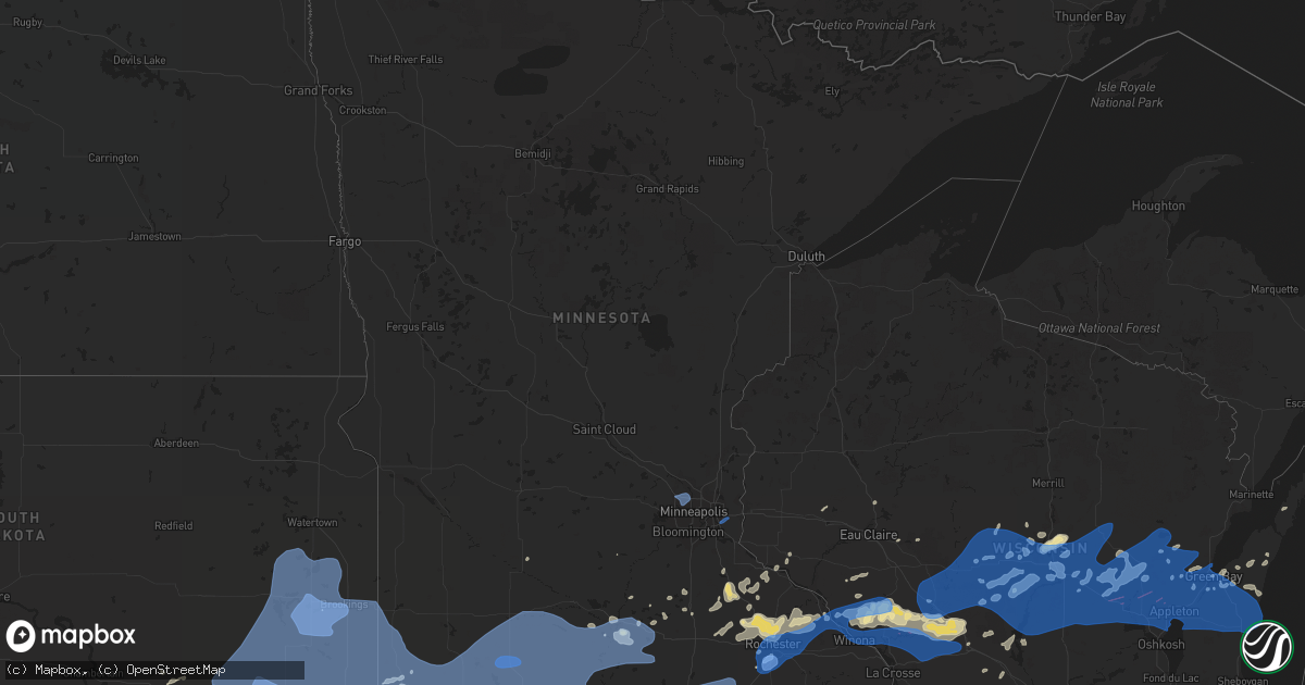
Hail Map in Minnesota on July 20, 2019
Get this storm
July 20 map
$229
one time, instant access
Download today. No call, no setup
Keep the $229
Bought the map and want the full workflow? Apply the entire $229 to a subscription within 7 days. None of it is wasted.
Every map, not just this one
This buys you this map. Subscription and you get every map we run, in the markets you choose from a few cities to whole states to nationwide. Plus real-time alerts the moment a storm fires.
Contact data
Name, contact info, occupancy, even credit band for addresses in the footprint. You go from where it hit to who to call.
Become the source they trust
Unlimited branding weather history reports on demand. You already have the documented answer ready for the property owner, and you are the one who showed up with it.
Property data and RoofTrace estimates
Pull up any address you have got, its value and the exact code rules for that jurisdiction, straight from One Click Code. Then RoofTrace estimates the squares, pitch, and roof value, priced the way you price.
Storm reports in Minnesota
Minnesota
| Date | Description |
|---|---|
| 07/20/201912:12 PM CDT | Report of trees down |
| 07/20/201911:42 AM CDT | Via personal weather station near century hills. Power outages. |
| 07/20/201911:38 AM CDT | Asos station krst rochester international airport. |
| 07/20/201911:34 AM CDT | A local report indicates 64 MPH wind near ROCHESTER AIRPORT |
| 07/20/201911:32 AM CDT | Social media photo of large portion of tree down. Relayed via broadcast media. Time estimated from radar. |
| 07/20/201911:32 AM CDT | A local report indicates 60 MPH wind near 1 NW ROCHESTER |
| 07/20/201911:30 AM CDT | 2-4 inch branches down. Picture on facebook. |
| 07/20/201911:24 AM CDT | Numerous trees reported down in town |
| 07/20/201911:24 AM CDT | Large tree down in northwest austin. Social media photo relayed by broadcast media. |
| 07/20/201911:24 AM CDT | Tree uprooted. Relayed via broadcast media. Time estimated from radar. |
| 07/20/201911:22 AM CDT | Social media photos of trees down. Relayed via broadcast media. |
| 07/20/201911:20 AM CDT | A local report indicates 58 MPH wind near 2 W DODGE CENTER |
| 07/20/201911:16 AM CDT | Several 6 inch branches down across town. |
| 07/20/201911:15 AM CDT | Trees down around the fairgrounds... Time estimated. |
| 07/20/201911:15 AM CDT | Large tree uprooted and power lines down in east park. Time estimated from radar. |
| 07/20/201911:15 AM CDT | Tree uprooted at owatonna country club. Time estimated. |
| 07/20/201911:05 AM CDT | Widespread tree damage... Roof damage to commercial building. Time estimated from radar. |
| 07/20/201911:01 AM CDT | A local report indicates 60 MPH wind near 1 N HAYWARD |
| 07/20/201911:00 AM CDT | Medium to large branches down and estimated 50-60mph gusts. |
| 07/20/201911:00 AM CDT | 6 inch branch down... Other smaller branches also down. |
| 07/20/201911:00 AM CDT | A local report indicates 60 MPH wind near BAYPORT |
| 07/20/201911:00 AM CDT | Large tree branches down. |
| 07/20/201911:00 AM CDT | Large tree snapped at base. Time estimated. |
| 07/20/201911:00 AM CDT | Several trees and branches down. Pictures via facebook. |
| 07/20/201910:51 AM CDT | 12 to 16 inch diameter limb broken off on southwest corner of county road 45 and 250 st. Noted that much of the cornfield visible from 45 was laid over in that area. Ab |
| 07/20/201910:50 AM CDT | Multiple trees down across town. |
| 07/20/201910:45 AM CDT | Spotter reports large tree branches down in and around waldorf. |
| 07/20/201910:38 AM CDT | Multiple trees down across town. |
| 07/20/201910:30 AM CDT | 4 inch diameter branches down. |
| 07/20/201910:15 AM CDT | Pine tree uprooted and large branches down. |
| 07/20/201910:04 AM CDT | Awos station kfrm fairmont ap. |
| 07/20/20199:55 AM CDT | Spotter estimates gusts to around 60mph... Power knocked out in st. James area. |
| 07/20/20199:49 AM CDT | Tree branches down in woodbury. Gust recorded via home weather station. |
| 07/20/20199:37 AM CDT | Awos station kmwm windom municipal airport. |
| 07/20/20199:30 AM CDT | Lakefield rwis station. |
| 07/20/20199:15 AM CDT | Mesonet station mn038 dovray mn-30 mile post 49. |
| 07/20/20199:13 AM CDT | Rwis station. |
| 07/20/20199:00 AM CDT | Mesonet station mn007 i-90 mile post 35. |
| 07/20/20199:00 AM CDT | Mature oak tree down across 57th ave... Snapped off 8ft from base. |
| 07/20/20198:57 AM CDT | Asos station krst rochester international airport. |
| 07/20/20198:57 AM CDT | Reports of trees and power lines down in town |
| 07/20/20198:45 AM CDT | 50 foot tree fell on a deck in rural north side of rochester. |
| 07/20/20198:35 AM CDT | Mesonet station mn006 beaver creek i-90 mile post 4. |
| 07/20/20198:30 AM CDT | Asos station kmic crystal ap. |
| 07/20/20198:30 AM CDT | Large tree... Branches down on top of vehicle... Roof. Pictures on facebook. |
| 07/20/20198:12 AM CDT | Pipestone raws station. Time estimated from radar. |
| 07/20/20196:16 AM CDT | At 1116 AM CDT, severe thunderstorms were located along a line extending from near London to 8 miles southeast of Garner, moving east at 50 mph. HAZARD...60 mph wind gusts. SOURCE...Radar indicated. IMPACT...Expect damage to roofs, siding, and trees. Severe thunderstorms will be near... Lyle around 1125 AM CDT. Stacyville around 1135 AM CDT. Rockford around 1150 AM CDT. Marble Rock around 1155 AM CDT. Nashua around 1215 PM CDT.Other locations impacted by these severe thunderstorms include CountyRoads A 39 And S 70, Meyer, Toeterville, County Roads B 60 And T 18,Rock Creek, Idlewilde State Park and Otranto. |
| 07/20/20196:04 AM CDT | At 1104 AM CDT, severe thunderstorms were located along a line extending from near Glenville to 8 miles northwest of Belmond, moving east at 85 mph. HAZARD...60 mph wind gusts. SOURCE...Radar indicated. At around 1100am tree damage and 60 mph winds were reported in Forest City. IMPACT...Expect damage to roofs, siding, and trees. Locations impacted include... Mason City, Forest City, Garner, Northwood, Lake Mills, Manly, Rockwell, Emmons, Clear Lake, Eagle Lake, Mason City Municipal Airport, Rice Lake, Ventura, Kanawha, Klemme, Thornton, Plymouth, Fertile, Leland and Kensett.This includes Interstate 35 between mile markers 178 and 218. |
| 07/20/20195:56 AM CDT | At 1053 AM CDT, severe thunderstorms were located along a line extending from near Faribault to Emmons, moving east at 70 mph. HAZARD...60 mph wind gusts and penny size hail. SOURCE...Radar indicated. This storm has a hisotory of producing 60 to 65 mph wind gusts. IMPACT...Expect damage to roofs, siding, and trees. Severe thunderstorms will be near... Lyle around 1115 AM CDT. Rose Creek around 1120 AM CDT. Oronoco and Adams around 1125 AM CDT. Le Roy around 1135 AM CDT.Other locations impacted by these severe thunderstorms include I 90Exit 218, Eden, Highway 57 And 570th Street, County Roads 6 And 15,Hidden Meadows R V Park, Rock Dell and Brookside Campground.Those attending the Dodge County Fair are in the path of these storms and should prepare for damaging winds. SEEK SHELTER NOW! |
| 07/20/20195:34 AM CDT | At 1033 AM CDT, a severe thunderstorm was located near Janesville, or 12 miles southeast of Mankato, moving east at 55 mph. This storm has a history of producing wind gusts in excess of 60 mph. HAZARD...60 mph wind gusts. SOURCE...Radar indicated. IMPACT...Expect damage to roofs, siding, and trees. Locations impacted include... Owatonna, Faribault, Waseca, Janesville, Blooming Prairie, Waterville, Medford, New Richland, Madison Lake, Morristown, Ellendale and Elysian.This includes the following highways... Interstate 35 between mile markers 26 and 59. U.S. Highway 14 between mile markers 142 and 182. |
| 07/20/20195:15 AM CDT | At 1014 AM CDT, severe thunderstorms were located along a line extending from near Iowa Lake to 6 miles east of Five Island Lake to near Albert City, moving east at 55 mph. HAZARD...60 mph wind gusts. SOURCE...Radar indicated. At 1001am a 64 mph wind gust was reported at the Estherville airport. IMPACT...Expect damage to roofs, siding, and trees. Locations impacted include... Algona, Pocahontas, Laurens, Union Slogh, West Bend, Bancroft, Fonda, Rolfe, Swea City, Burt, Whittemore, Gilmore City, Titonka, Wesley, Livermore, Corwith, Bode, Fenton, Mallard and Lu Verne. |
| 07/20/20194:51 AM CDT | At 951 AM CDT, severe thunderstorms were located along a line extending from near Galesville to near Dakota, moving east at 60 mph. HAZARD...60 mph wind gusts. SOURCE...Radar indicated. IMPACT...Expect damage to roofs, siding, and trees. Severe thunderstorms will be near... Brice Prairie around 955 AM CDT. La Crosse, Onalaska, Holmen, La Crosse Airport and French Island around 1000 AM CDT. West Salem around 1010 AM CDT. Bangor around 1015 AM CDT.People attending the La Crosse Interstate Fair should seek safe shelter immediately! |
| 07/20/20194:38 AM CDT | At 938 AM CDT, severe thunderstorms were located along a line extending from 6 miles northwest of Independence to Arcadia to near Winona, moving east at 40 mph. HAZARD...60 mph wind gusts. SOURCE...Radar indicated. IMPACT...Expect damage to roofs, siding, and trees. Severe thunderstorms will be near... Independence and Strum around 945 AM CDT. Whitehall around 950 AM CDT. Galesville around 955 AM CDT. Blair around 1000 AM CDT.Other locations impacted by these severe thunderstorms includeHighway 95 And County D, Camp Decorah, Beach Corners, Perrot StatePark, Chimney Rock, Thimble Park and Elk Creek. |
| 07/20/20194:20 AM CDT | At 919 AM CDT, severe thunderstorms were located along a line extending from 7 miles northeast of Wabasha to near Altura to Chatfield, moving east at 50 mph. HAZARD...60 mph wind gusts. SOURCE...Radar indicated. IMPACT...Expect damage to roofs, siding, and trees. Severe thunderstorms will be near... Lewiston around 925 AM CDT. Fountain City, Stockton, Rollingstone and Modena around 930 AM CDT. Winona and Goodview around 935 AM CDT. Dakota around 955 AM CDT.Other locations impacted by these severe thunderstorms includePioneer Campground, Merrick State Park, Cream, I 90 Exit 257, Highway88 And County O, Ridgeway and County Roads 28 And 31. |
| 07/20/20193:45 AM CDT | At 844 AM CDT, a severe thunderstorm was located near Arcadia, moving east at 40 mph. HAZARD...70 mph wind gusts and penny size hail. SOURCE...Radar indicated. IMPACT...Expect considerable tree damage. Damage is likely to mobile homes, roofs, and outbuildings. This severe thunderstorm will be near... Blair around 910 AM CDT.Other locations impacted by this severe thunderstorm includeFranklin, Melrose, Camp Decorah, Beach Corners, York, I 94 Exit 98and Perrot State Park. |
| 07/20/20193:28 AM CDT | At 828 AM CDT, severe thunderstorms were located along a line extending from near Tyler to near Edgerton to Rowena, moving east at 60 mph. HAZARD...70 mph wind gusts. SOURCE...Radar indicated. IMPACT...Expect considerable tree damage. Damage is likely to mobile homes, roofs, and outbuildings. Severe thunderstorms will be near... Leota, Russell, Chandler, Lake Wilson, Woodstock and Camden State Park around 835 AM CDT. Balaton around 840 AM CDT. Slayton around 845 AM CDT. Tracy around 850 AM CDT. Fulda and Ellsworth around 855 AM CDT. Westbrook and Rushmore around 905 AM CDT. Storden around 910 AM CDT. Jeffers around 915 AM CDT.Other locations impacted by these severe thunderstorms include Ihlen,Lynd, Dundee, Steen, Magnolia, Bigelow, Hatfield, Kenneth, Avoca andHadley. |
| 07/20/20192:59 AM CDT | At 758 AM CDT, severe thunderstorms were located along a line extending from 6 miles northeast of Plainview to 6 miles north of St. Charles, moving east at 20 mph. HAZARD...60 mph wind gusts. SOURCE...Radar indicated. IMPACT...Expect damage to roofs, siding, and trees. Severe thunderstorms will be near... Kellogg around 815 AM CDT. Altura around 820 AM CDT. Buffalo and Buffalo City around 825 AM CDT. Alma around 830 AM CDT. Stockton and Rollingstone around 835 AM CDT. Winona, Goodview and Fountain City around 845 AM CDT.Other locations impacted by these severe thunderstorms includeWhitewater State Park, Pioneer Campground, Merrick State Park,Czechville, Lock And Dam 5 A, Dodge and Cream. |
| 07/20/20192:08 AM CDT | At 707 AM CDT, severe thunderstorms were located along a line extending from near Badger to 8 miles southwest of Oldham to near Fulton, moving east at 55 mph. HAZARD...70 mph wind gusts and quarter size hail. SOURCE...Radar indicated. IMPACT...Hail damage to vehicles is expected. Expect considerable tree damage. Wind damage is also likely to mobile homes, roofs, and outbuildings. Severe thunderstorms will be near... Oldham, Badger, Lake Poinsett and Lake Albert around 710 AM CDT. Ramona around 715 AM CDT. Emery, Bruce, Spencer In McCook County and Oakwood State Park around 720 AM CDT. Madison around 725 AM CDT. Wentworth and Nunda around 730 AM CDT. Salem and White around 735 AM CDT. Canistota and Colman around 740 AM CDT. Lake Vermillion State Recreation Area, Flandreau, Hendricks, Humboldt, Montrose and Egan around 745 AM CDT.Other locations impacted by these severe thunderstorms includeBushnell. |
| 07/20/20191:32 AM CDT | At 632 AM CDT, a severe thunderstorm was located near St. Peter, or 16 miles north of Mankato, moving east at 20 mph. HAZARD...Half dollar size hail. SOURCE...Radar indicated. IMPACT...Damage to vehicles is expected. This severe thunderstorm will be near... St. Peter around 635 AM CDT. Le Sueur around 655 AM CDT. Henderson around 700 AM CDT.Other locations impacted by this severe thunderstorm include RushRiver, Ottawa, St Henry, Norseland and St Thomas.This includes U.S. Highway 169 between mile markers 69 and 83. |
| 07/20/20191:01 AM CDT | At 601 AM CDT, a severe thunderstorm was located over Westbrook, or 15 miles east of Slayton, moving northeast at 25 mph. HAZARD...Quarter size hail. SOURCE...Radar indicated. IMPACT...Damage to vehicles is expected. This severe thunderstorm will be near... Storden around 615 AM CDT. Jeffers around 630 AM CDT. |
All States Impacted by Hail Map on July 20, 2019
Cities Impacted by Hail Map on July 20, 2019
- Moulton, IA
- Jamestown, CO
- Longmont, CO
- Boulder, CO
- Ward, CO
- Rose Hill, IA
- Hedrick, IA
- Sigourney, IA
- Delta, IA
- Colorado Springs, CO
- Idalia, CO
- McCool Junction, NE
- Fairmont, NE
- York, NE
- Henderson, NE
- Centerville, IA
- Udell, IA
- Princeton, MO
- Spickard, MO
- Jackman, ME
- Graettinger, IA
- Emmetsburg, IA
- Pulaski, IA
- Stinnett, KY
- Hyden, KY
- Arcadia, WI
- Holcomb, KS
- Garden City, KS
- Sully, IA
- Lynnville, IA
- Granite Falls, NC
- Hudson, NC
- Leoti, KS
- Bonduel, WI
- Amherst, WI
- Churdan, IA
- Jefferson, IA
- Ralston, IA
- Glidden, IA
- Scranton, IA
- Berryville, VA
- Boyce, VA
- Bluemont, VA
- Front Royal, VA
- Sublette, KS
- Satanta, KS
- Venus, PA
- Brookfield, MO
- Chariton, IA
- Russell, IA
- Sedalia, CO
- Divide, CO
- Pueblo, CO
- New London, WI
- Bear Creek, WI
- Rockville, NE
- Boelus, NE
- Denver, CO
- Morrison, CO
- Golden, CO
- Sanderson, FL
- Alzada, MT
- Cheyenne, WY
- Montrose, SD
- Canistota, SD
- Archer, IA
- Sheldon, IA
- Hartley, IA
- Sutherland, IA
- Primghar, IA
- Sanborn, IA
- Paullina, IA
- Gayville, SD
- Burlington, CO
- Kirk, CO
- Letcher, KY
- Blackey, KY
- Cornettsville, KY
- Carsonville, MI
- Davis City, IA
- Leon, IA
- Decatur, IA
- Cannon Falls, MN
- Kenyon, MN
- Dennison, MN
- Woodward, IA
- Dannebrog, NE
- Grand Island, NE
- Cairo, NE
- Saint Libory, NE
- Oconto, NE
- Ansley, NE
- Clifford, MI
- Mayville, MI
- Silverwood, MI
- La Junta, CO
- Saint Joseph, MO
- Cosby, MO
- Savannah, MO
- Prairie City, IA
- Runnells, IA
- Custer, MI
- Chase, MI
- Branch, MI
- Baldwin, MI
- Scottville, MI
- Big Rapids, MI
- Free Soil, MI
- Irons, MI
- Hersey, MI
- Rodney, MI
- Paris, MI
- Idlewild, MI
- Bitely, MI
- Luther, MI
- Reed City, MI
- Ludington, MI
- Fountain, MI
- Indianola, IA
- Guilford, MO
- Larkspur, CO
- Monument, CO
- Las Animas, CO
- New Hampton, MO
- McFall, MO
- Bethany, MO
- Lamar, CO
- Granada, CO
- Holly, CO
- Northville, MI
- Howe, IN
- Stratton, CO
- Yoder, CO
- Chili, WI
- Marshfield, WI
- Millville, MN
- Mazeppa, MN
- Oronoco, MN
- West Concord, MN
- Rochester, MN
- Pine Island, MN
- Zumbro Falls, MN
- Zumbrota, MN
- Elgin, MN
- Lexington, NE
- Cleveland, OH
- Lucas, IA
- Lacona, IA
- Lovilia, IA
- Melrose, IA
- Albia, IA
- Greenville, ME
- Vona, CO
- Weston, WY
- Brady, NE
- Hayes Center, NE
- Lafayette, CO
- Olney Springs, CO
- Sugar City, CO
- Ordway, CO
- Rock River, WY
- Whitley City, KY
- Palm Harbor, FL
- Mineral Point, WI
- Darlington, WI
- Barrington, IL
- Casco, WI
- Luxemburg, WI
- Milford, IA
- Weldon, IA
- Apex, NC
- Cary, NC
- Bear Creek, NC
- Sanford, NC
- Magnolia, MN
- Luverne, MN
- Cozad, NE
- Rea, MO
- Rosendale, MO
- Bolckow, MO
- New Port Richey, FL
- Monroe, IA
- Beaver Crossing, NE
- Mankato, MN
- Benkelman, NE
- Seibert, CO
- Wyaconda, MO
- Auburndale, WI
- Hewitt, WI
- Edgerton, MN
- Barnard, MO
- Conception Junction, MO
- Kit Carson, CO
- Grenville, NM
- Dunnellon, FL
- Taylorsville, NC
- Black River Falls, WI
- Sparta, WI
- Tomah, WI
- Warrens, WI
- Eads, CO
- Dunbar, NE
- Maitland, MO
- Skidmore, MO
- Floris, IA
- Bloomfield, IA
- Hamburg, IA
- Branson, CO
- Model, CO
- New Sharon, IA
- Adrian, MN
- Manlius, NY
- Cazenovia, NY
- Oregon, MO
- Fillmore, MO
- Winston, MO
- Weatherby, MO
- Leroy, MI
- Juda, WI
- Brodhead, WI
- Liberal, KS
- Wray, CO
- Saint Francis, KS
- Clearmont, WY
- Arvada, WY
- Green Bay, WI
- Moorefield, NE
- Cainsville, MO
- Winston Salem, NC
- Faribault, MN
- Reeseville, WI
- Columbus, WI
- Perry, IA
- Pleasantville, IA
- Knoxville, IA
- Pattonsburg, MO
- Salix, IA
- Pulaski, WI
- Amsterdam, NY
- Pattersonville, NY
- North Bloomfield, OH
- Orwell, OH
- Empire, MI
- Dodgeville, WI
- Barneveld, WI
- Ridgeway, WI
- Elkhorn, WI
- Fremont, IA
- Oskaloosa, IA
- Valparaiso, NE
- Baring, MO
- Grainfield, KS
- Sarasota, FL
- Spirit Lake, IA
- Mosinee, WI
- Pleasant Dale, NE
- Hillsboro, IA
- Saint Petersburg, FL
- Steen, MN
- Kanaranzi, MN
- Ellsworth, MN
- Plainview, MN
- Marienthal, KS
- Granton, WI
- Pittsville, WI
- Norwalk, IA
- Callaway, NE
- Unionville, MO
- Green Castle, MO
- Newell, SD
- Eleva, WI
- Mondovi, WI
- Mitchellville, IA
- Swan, IA
- Searsboro, IA
- Reasnor, IA
- Otley, IA
- Altoona, IA
- Pella, IA
- Melcher Dallas, IA
- Traverse City, MI
- Lake Ann, MI
- Irwin, IA
- Kirkman, IA
- Elsie, NE
- Tribune, KS
- Broken Bow, NE
- Novinger, MO
- Worthington, MO
- Nebraska City, NE
- Hasty, CO
- Eagle Lake, MN
- Madison Lake, MN
- Guthrie Center, IA
- Imperial, NE
- Advance, NC
- Oregon, WI
- Stoughton, WI
- Boone, CO
- Altamont, MO
- Avondale, CO
- Plover, WI
- Junction City, WI
- Stevens Point, WI
- North Platte, NE
- Watertown, WI
- Blair, WI
- Ettrick, WI
- Lake Zurich, IL
- Mundelein, IL
- Union Star, MO
- Clarksdale, MO
- Amity, MO
- King City, MO
- Fox River Grove, IL
- Algonquin, IL
- Dundee, IL
- Cary, IL
- Carpentersville, IL
- Greenville Junction, ME
- Rockwood, ME
- Maysville, MO
- Watson, MO
- Peru, NE
- Brownville, NE
- Rock Port, MO
- Coon Rapids, IA
- Audubon, IA
- Edgerton, WI
- Evansville, WI
- Windsor, OH
- Middlefield, OH
- Vicco, KY
- Sassafras, KY
- Viper, KY
- Isom, KY
- Scuddy, KY
- Redfox, KY
- Roxana, KY
- Jeremiah, KY
- Whitesburg, KY
- North Port, FL
- Fort Myers, FL
- Thomasville, NC
- Lake Geneva, WI
- Springfield, WI
- Burlington, WI
- Trinidad, CO
- Rosholt, WI
- Hatley, WI
- Hesperia, MI
- Lexington, NC
- Milwaukee, WI
- Oak Creek, WI
- Franklin, WI
- Waterloo, WI
- Jamaica, IA
- Gates Mills, OH
- Chesterland, OH
- Branchville, NJ
- Mason City, NE
- Lineville, IA
- Byron, MN
- White Post, VA
- Spencer, IA
- Skaneateles, NY
- Auburn, NY
- Claremont, MN
- Oxford, MI
- New Era, MI
- Cochrane, WI
- Newton, IA
- Helena, MO
- Milo, IA
- Granger, IA
- Madrid, IA
- Janesville, MN
- Farmington, MI
- Williamson, IA
- London, KY
- Kellogg, IA
- Downing, MO
- Memphis, MO
- Volga, SD
- Bremen, IN
- Algoma, WI
- Niobrara, NE
- Fairfield, IA
- New Boston, MO
- Darlington, MO
- Albany, MO
- Lake Crystal, MN
- Janesville, WI
- Rocky Ford, CO
- Tampa, FL
- Kilkenny, MN
- Montgomery, MN
- South Wayne, WI
- Monticello, NY
- Vowinckel, PA
- Lucinda, PA
- Marble, PA
- Lickingville, PA
- Fryburg, PA
- Leeper, PA
- Shippenville, PA
- Cooksburg, PA
- Murfreesboro, TN
- Smyrna, TN
- Gainesville, FL
- Oneida, NY
- Oneill, NE
- Sumner, NE
- Luray, MO
- Arbela, MO
- Knox City, MO
- Gorin, MO
- La Belle, MO
- Rutledge, MO
- Oneida, WI
- Seymour, WI
- Ogdensburg, WI
- New Franken, WI
- Hardwick, MN
- Camden, NY
- Taberg, NY
- Blossvale, NY
- Everly, IA
- Maywood, NE
- Westboro, MO
- Tarkio, MO
- Fairfax, MO
- Lake City, IA
- Lohrville, IA
- Stratton, NE
- Browning, MO
- Humphreys, MO
- Gillette, WY
- De Pere, WI
- Monroe, WI
- Milan, MO
- Deckerville, MI
- Sandusky, MI
- Port Sanilac, MI
- Brooksville, FL
- Hanna, WY
- Medicine Bow, WY
- Fountain City, WI
- Scott City, KS
- Marion, SD
- Corydon, IA
- Rudd, IA
- Hospers, IA
- Orange City, IA
- Carroll, IA
- Monticello, KY
- Bronston, KY
- Lake George, CO
- Estes Park, CO
- Cape Coral, FL
- Randolph, MN
- Royal, IA
- Dedham, IA
- Culbertson, NE
- Prole, IA
- Wood River, NE
- Burlington Junction, MO
- Promise City, IA
- Seymour, IA
- Athens, PA
- Powersville, MO
- Hart, MI
- Rome, NY
- Sheridan Lake, CO
- Gilman City, MO
- Rothbury, MI
- Stanberry, MO
- Conception, MO
- Deerfield, IL
- Lake Forest, IL
- Libertyville, IL
- Vernon Hills, IL
- Lincolnshire, IL
- Woodland Park, CO
- Green Mountain Falls, CO
- Oneida, TN
- Taylor, WI
- Whitehall, WI
- Melrose, WI
- Independence, WI
- Dodge, WI
- Galesville, WI
- Union, NE
- Percival, IA
- Elk Point, SD
- Eldon, IA
- Agency, IA
- Ottumwa, IA
- Maxwell, NE
- Miller, NE
- Stewartville, MN
- Lake Butler, FL
- Brooker, FL
- Boyd, WI
- Custer, WI
- Redfield, IA
- Earlham, IA
- Fremont, OH
- Pittsboro, NC
- Fostoria, OH
- Kansas, OH
- Columbia, IA
- Hamilton, IA
- Green City, MO
- Maiden Rock, WI
- Humboldt, SD
- Gruver, TX
- Ocala, FL
- Eddyville, NE
- Wallace, NE
- Bosler, WY
- Red Wing, MN
- Waco, NE
- Van Wert, IA
- Garden Grove, IA
- Newtown, MO
- Lucerne, MO
- New Virginia, IA
- Mocksville, NC
- Lyons, CO
- Leighton, IA
- Champion, NE
- Saint Peter, MN
- Cleveland, MN
- Morristown, MN
- Waterville, MN
- Gothenburg, NE
- La Plata, MO
- Kirksville, MO
- Gibbs, MO
- Casey, IA
- Bagley, IA
- Yale, IA
- Stuart, IA
- Panora, IA
- Bayard, IA
- Menlo, IA
- Dexter, IA
- Overton, NE
- Arlington, CO
- Somerset, KY
- Swink, CO
- Shelby, MI
- White Cloud, MI
- Walkerville, MI
- Montague, MI
- Glenrock, WY
- Gallatin, TN
- Milladore, WI
- Altura, MN
- Mantorville, MN
- Eyota, MN
- Kasson, MN
- Kellogg, MN
- Dodge Center, MN
- Arkdale, WI
- Saint Charles, MI
- Haswell, CO
- Cookeville, TN
- Thurman, IA
- Sidney, IA
- Boyceville, WI
- Menomonie, WI
- Lena, IL
- Marion, WI
- Oriskany Falls, NY
- Goldston, NC
- Trinity, NC
- Parrish, FL
- Union Center, SD
- Clearmont, MO
- Scandinavia, WI
- Clintonville, WI
- Waupaca, WI
- Tigerton, WI
- Iola, WI
- Manawa, WI
- Weyauwega, WI
- Greentop, MO
- Brashear, MO
- Sibley, IA
- Little Rock, IA
- Humeston, IA
- Woodburn, IA
- Derby, IA
- Marquette, NE
- Lonsdale, MN
- Troy, NY
- Murray, NE
- Weskan, KS
- White Lake, SD
- Madison, WI
- Ridgeway, MO
- Bay City, WI
- Winona, KS
- Rickman, TN
- Livingston, TN
- Jasper, MN
- Colfax, IA
- Amazonia, MO
- Allardt, TN
- Sunbright, TN
- Trempealeau, WI
- Saginaw, MI
- Shawano, WI
- Slemp, KY
- Black Creek, WI
- Bird Island, MN
- Olivia, MN
- Franklin, MN
- Goodhue, MN
- Le Center, MN
- Maryville, MO
- Boscobel, WI
- Fennimore, WI
- High Point, NC
- Statesville, NC
- Oconomowoc, WI
- Ixonia, WI
- Newbury, OH
- Pentwater, MI
- Breckenridge, MO
- Spring Hill, FL
- Osmond, NE
- Hazard, NE
- Litchfield, NE
- Seward, NE
- McCook, NE
- Littleton, CO
- Chestnut Mound, TN
- Baxter, TN
- Buffalo Valley, TN
- Silver Point, TN
- Kewaunee, WI
- Sloan, IA
- Hiddenite, NC
- Stony Point, NC
- Mount Ayr, IA
- Morriston, FL
- Fall Creek, WI
- Defiance, IA
- Earling, IA
- Burton, OH
- Clarinda, IA
- Arcadia, FL
- Remsen, IA
- Randleman, NC
- Livonia, MO
- Maurice, IA
- Gallatin, MO
- Wisconsin Rapids, WI
- Vesper, WI
- Wellfleet, NE
- Bloomer, WI
- Chippewa Falls, WI
- Camp Douglas, WI
- Manzanola, CO
- Madison, NY
- Bradenton, FL
- Ogden, IA
- Verona, WI
- Elkhorn City, KY
- Reddick, FL
- Galt, MO
- Elroy, WI
- Mauston, WI
- Osceola, IA
- Venice, FL
- Lancaster, WI
- Albany, WI
- Tracy, IA
- Bussey, IA
- Parks, NE
- Mount Juliet, TN
- Gower, MO
- Stewartsville, MO
- Plattsburg, MO
- Trimble, MO
- Manning, IA
- Conneaut Lake, PA
- Cameron, MO
- Hamilton, MO
- Adair, IA
- Grafton, NE
- Myakka City, FL
- Breda, IA
- Shelton, NE
- Sophia, NC
- North Branch, MI
- Fostoria, MI
- Terril, IA
- Dickens, IA
- Le Mars, IA
- Ireton, IA
- Vermillion, SD
- Amherst Junction, WI
- Bentonville, VA
- Nerstrand, MN
- Plankinton, SD
- Asheboro, NC
- Cheyenne Wells, CO
- Wildwood, FL
- Oxford, FL
- Hickman, TN
- Hilliard, FL
- Callahan, FL
- Good Thunder, MN
- Constantia, NY
- West Monroe, NY
- Glen Arbor, MI
- Ruthven, IA
- Estherville, IA
- Olin, NC
- Union Grove, NC
- West Farmington, OH
- Snover, MI
- Palms, MI
- Homosassa, FL
- Lecanto, FL
- Kendall, WI
- Syracuse, NY
- Nedrow, NY
- Marietta, NY
- Harmony, NC
- Queen City, MO
- Highland, WI
- Montfort, WI
- Muscoda, WI
- Clairfield, TN
- Deerfield, KS
- Alachua, FL
- Wesley, IA
- Kingsley, IA
- Amherst, NE
- Pleasanton, NE
- Franklinton, NC
- Plano, IA
- Trenton, MO
- Jameson, MO
- Kidder, MO
- Texhoma, OK
- Fonda, NY
- Fultonville, NY
- Fort Hunter, NY
- Beaver Creek, MN
- Algona, IA
- Jones, MI
- Laredo, MO
- Kenton, OK
- Linneus, MO
- Purdin, MO
- Beresford, SD
- Burbank, SD
- Solon, OH
- Bedford, OH
- Chagrin Falls, OH
- Micanopy, FL
- Deer Lodge, TN
- Blythedale, MO
- Eagleville, MO
- Aurora, NE
- Pine Knot, KY
- Strunk, KY
- Revelo, KY
- Marlette, MI
- Summerfield, FL
- Marathon, WI
- Manitou Springs, CO
- McClave, CO
- Beloit, WI
- Perryton, TX
- Arlington Heights, IL
- Wheeling, IL
- Palatine, IL
- Pollock, MO
- Guymon, OK
- Ledger, MT
- Conrad, MT
- Buchanan, MI
- Galien, MI
- Rudolph, WI
- Middletown, VA
- Manistee, MI
- Ackworth, IA
- Liberty Center, IA
- Morganton, NC
- Egg Harbor, WI
- Ollie, IA
- Packwood, IA
- Barre, VT
- Montpelier, VT
- Bee, NE
- Mercer, MO
- Burt, IA
- Denmark, WI
- Unity, WI
- Spencer, WI
- Stratford, WI
- Colby, WI
- Pickering, MO
- Alcester, SD
- Chardon, OH
- New Hampton, IA
- Green Isle, MN
- Bradshaw, NE
- Naples, FL
- Stockville, NE
- Lebanon, TN
- Arpin, WI
- Welch, MN
- Mapleton, MN
- Necedah, WI
- Rushmore, MN
- Blanchardville, WI
- Hollandale, WI
- Hickory, NC
- Cobb, WI
- Braddyville, IA
- Elmo, MO
- Jamesport, MO
- Alton, IA
- Granville, IA
- Dallas Center, IA
- Polk City, IA
- Rippey, IA
- Bouton, IA
- Grand Junction, IA
- Le Roy, MN
- Reese, MI
- Old Town, FL
- Dawson, IA
- Ridott, IL
- Pecatonica, IL
- Batavia, IA
- Wiley, CO
- Hudson, FL
- Parkers Lake, KY
- Elizabeth, IL
- Savanna, IL
- Kellerton, IA
- Hatfield, MO
- Forestville, WI
- Villisca, IA
- Cumberland, IA
- Murdock, NE
- Weeping Water, NE
- Cascade, CO
- Peyton, CO
- Calhan, CO
- Albany, NY
- Berlin, NY
- Stephentown, NY
- Palatine Bridge, NY
- Marcy, NY
- Petersburg, NY
- Schenectady, NY
- Nelliston, NY
- Latham, NY
- Ilion, NY
- Tribes Hill, NY
- Fort Johnson, NY
- New Hartford, NY
- Johnstown, NY
- Yorkville, NY
- Frankfort, NY
- Clifton Park, NY
- Utica, NY
- Wynantskill, NY
- Rotterdam Junction, NY
- Alplaus, NY
- Oriskany, NY
- Cohoes, NY
- Whitesboro, NY
- Mohawk, NY
- Sand Lake, NY
- Little Falls, NY
- Westmoreland, NY
- Lanesborough, MA
- Watervliet, NY
- Fort Plain, NY
- Herkimer, NY
- New York Mills, NY
- Williamstown, MA
- Hagaman, NY
- Averill Park, NY
- Rexford, NY
- Poestenkill, NY
- Saint Johnsville, NY
- Barnes City, IA
- Pleasant Hill, IA
- Johnston, IA
- Blakesburg, IA
- Hartford, IA
- Richland, IA
- Bondurant, IA
- Ankeny, IA
- Clive, IA
- What Cheer, IA
- Beacon, IA
- Urbandale, IA
- Minburn, IA
- Berwick, IA
- Hayesville, IA
- University Park, IA
- Windsor Heights, IA
- Kirkville, IA
- Martinsburg, IA
- Harvey, IA
- Carlisle, IA
- Waukee, IA
- Eddyville, IA
- West Des Moines, IA
- Des Moines, IA
- Cedar, IA
- Adel, IA
- Grimes, IA
- Elkhart, IA
- Chillicothe, IA
- Lenoir, NC
- Estelline, SD
- Lake Benton, MN
- Swea City, IA
- Aurora, SD
- Oldham, SD
- Colman, SD
- Mountain Lake, MN
- Fairmont, MN
- Iona, MN
- Worthing, SD
- Woodstock, MN
- Harrisburg, SD
- Lake Preston, SD
- Canton, SD
- Ledyard, IA
- Britt, IA
- Arnolds Park, IA
- Welcome, MN
- Brandon, SD
- Madelia, MN
- Trimont, MN
- Avoca, MN
- Doon, IA
- Wentworth, SD
- Crystal Lake, IA
- Pemberton, MN
- Nunda, SD
- Egan, SD
- Castlewood, SD
- Colton, SD
- Howard, SD
- Garretson, SD
- Renner, SD
- Odin, MN
- Minnesota Lake, MN
- Saint Clair, MN
- Jeffers, MN
- Artesian, SD
- Ventura, IA
- Lester, IA
- Granada, MN
- Lakota, IA
- Brookings, SD
- Livermore, IA
- Sinai, SD
- Ashton, IA
- George, IA
- Parker, SD
- Butterfield, MN
- Sanborn, MN
- Dell Rapids, SD
- Salem, SD
- Hayti, SD
- Winnebago, MN
- Fulton, SD
- Fertile, IA
- Rock Rapids, IA
- New Richland, MN
- Elmore, MN
- Springfield, MN
- Garner, IA
- Whittemore, IA
- Waldorf, MN
- Elkton, SD
- Windom, MN
- Monroe, SD
- Madison, SD
- Okoboji, IA
- Saint James, MN
- Amboy, MN
- Fostoria, IA
- Bryant, SD
- Reading, MN
- Mason City, IA
- Rockwell, IA
- Tea, SD
- Jackson, MN
- Letcher, SD
- Okabena, MN
- Cylinder, IA
- Bridgewater, SD
- Canova, SD
- De Smet, SD
- Lewisville, MN
- Winfred, SD
- Melvin, IA
- Lamberton, MN
- Alvord, IA
- Truman, MN
- Hartford, SD
- Hull, IA
- Crooks, SD
- Rutland, SD
- Sleepy Eye, MN
- Larchwood, IA
- New Ulm, MN
- Trent, SD
- Hanska, MN
- Alpha, MN
- Round Lake, MN
- Pipestone, MN
- Ocheyedan, IA
- Darfur, MN
- Valley Springs, SD
- Bingham Lake, MN
- Comfrey, MN
- Heron Lake, MN
- Flandreau, SD
- Alexandria, SD
- Carthage, SD
- Holland, MN
- Bode, IA
- Kenneth, MN
- Wilmont, MN
- Baltic, SD
- West Bend, IA
- Clear Lake, IA
- Lu Verne, IA
- Waseca, MN
- Ruthton, MN
- Boyden, IA
- Blue Earth, MN
- Dunnell, MN
- Vernon Center, MN
- Brewster, MN
- Titonka, IA
- Ramona, SD
- Chancellor, SD
- Chandler, MN
- Storden, MN
- White, SD
- Ormsby, MN
- Matlock, IA
- Fedora, SD
- Dolliver, IA
- Fenton, IA
- Ottosen, IA
- Bruce, SD
- Lone Rock, IA
- Worthington, MN
- Woden, IA
- Lake Norden, SD
- Lake Park, IA
- Buffalo Center, IA
- Forest City, IA
- Hills, MN
- Leota, MN
- Lakefield, MN
- Ringsted, IA
- Lismore, MN
- Harris, IA
- Emery, SD
- Fulda, MN
- Lyons, SD
- Sioux Falls, SD
- Spencer, SD
- Rock Valley, IA
- Chester, SD
- Inwood, IA
- Badger, SD
- Bigelow, MN
- Mitchell, SD
- Sherburn, MN
- Armstrong, IA
- Arlington, SD
- Garden City, MN
- Bancroft, IA
- Westbrook, MN
- Superior, IA
- Ceylon, MN
- Sioux Center, IA
- Wallingford, IA
- Erwin, SD
- Albert Lea, MN
- Lansing, MN
- Brownsdale, MN
- Austin, MN
- Hayward, MN
- Waltham, MN
- Hollandale, MN
- Rose Creek, MN
- Winona, MN
- Saint Charles, MN
- Chatfield, MN
- Bangor, WI
- West Salem, WI
- Rockland, WI
- Racine, MN
- Alma, WI
- Dover, MN
- Minnesota City, MN
- Holmen, WI
- Mindoro, WI
- Osseo, MN
- Minneapolis, MN
- Forest Junction, WI
- Maribel, WI
- Pine River, WI
- Hixton, WI
- Cecil, WI
- Nichols, WI
- Sherwood, WI
- Babcock, WI
- Edgar, WI
- Kaukauna, WI
- Menasha, WI
- Greenleaf, WI
- Little Chute, WI
- Friendship, WI
- Hortonville, WI
- Humbird, WI
- Wautoma, WI
- Suamico, WI
- Two Rivers, WI
- Appleton, WI
- Larsen, WI
- Manitowoc, WI
- Greenville, WI
- Embarrass, WI
- Neenah, WI
- Wrightstown, WI
- Francis Creek, WI
- Shiocton, WI
- Greenwood, WI
- Neillsville, WI
- Bancroft, WI
- Loyal, WI
- Hilbert, WI
- Whitelaw, WI
- Combined Locks, WI
- Plainfield, WI
- Brillion, WI
- Almond, WI
- Wittenberg, WI
- Reedsville, WI
- Nekoosa, WI
- Port Edwards, WI
- Alma Center, WI
- Fremont, WI
- Winneconne, WI
- Mishicot, WI
- Hancock, WI
- Eland, WI
- Kimberly, WI
- Oshkosh, WI
- Nelsonville, WI
- Merrillan, WI
- Wild Rose, WI
- Saint Paul, MN
- Benzonia, MI
- Buckley, MI
- Honor, MI
- Thompsonville, MI
- Grawn, MI
- Kingsley, MI
- Beulah, MI
- Interlochen, MI
- Frankfort, MI
- Brohman, MI
- Frankenmuth, MI
- Munger, MI
- Carrollton, MI
- Fenton, MI
- Davisburg, MI
- Linden, MI
- Holly, MI
- Royal Oak, MI
- Pleasant Ridge, MI
- Oak Park, MI
- Redford, MI
- Highland Park, MI
- Novi, MI
- Southfield, MI
- Ferndale, MI
- Detroit, MI
- Livonia, MI
- Huntington Woods, MI
- Hazel Park, MI
- Fowler, CO
- Crowley, CO
- Cheraw, CO


