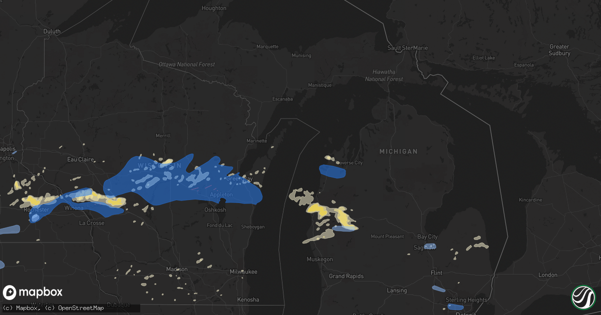
Hail Map in Michigan on July 20, 2019
Get this storm
July 20 map
$229
one time, instant access
Download today. No call, no setup
Keep the $229
Bought the map and want the full workflow? Apply the entire $229 to a subscription within 7 days. None of it is wasted.
Every map, not just this one
This buys you this map. Subscription and you get every map we run, in the markets you choose from a few cities to whole states to nationwide. Plus real-time alerts the moment a storm fires.
Contact data
Name, contact info, occupancy, even credit band for addresses in the footprint. You go from where it hit to who to call.
Become the source they trust
Unlimited branding weather history reports on demand. You already have the documented answer ready for the property owner, and you are the one who showed up with it.
Property data and RoofTrace estimates
Pull up any address you have got, its value and the exact code rules for that jurisdiction, straight from One Click Code. Then RoofTrace estimates the squares, pitch, and roof value, priced the way you price.
Storm reports in Michigan
Michigan
| Date | Description |
|---|---|
| 07/20/20196:05 PM CDT | Social media pictures of large tree limbs down. |
| 07/20/20196:02 PM CDT | A thunderstorm wind gust... 54 knots... 62 mph... Was measured at selfridge air national guard base. |
| 07/20/20195:55 PM CDT | Large downed trees and branches. Time estimated by radar. |
| 07/20/20195:52 PM CDT | Social media pictures of tree down at curry rd and 11 mile. |
| 07/20/20195:30 PM CDT | Pictures of a tree down on a house. |
| 07/20/20195:25 PM CDT | Construction speed limit signs snapped and blown down |
| 07/20/20195:24 PM CDT | Trees down. Time estimated by radar. |
| 07/20/20195:23 PM CDT | Many trees... Including large ones... Are down around across applegate |
| 07/20/20195:23 PM CDT | Social media pictures of corn nearly flattened and small-to-medium sized tree branches down. |
| 07/20/20195:13 PM CDT | Trees down throughout the area. |
| 07/20/20194:58 PM CDT | Large tree limbs down in downtown lapeer |
| 07/20/20194:55 PM CDT | Station number mi-lp-9 |
| 07/20/20194:51 PM CDT | West-facing closed garage door partly blown in. Small trees down. |
| 07/20/20194:45 PM CDT | Trees down at the intersection of lapeer and genesee roads. Time estimated by radar. |
| 07/20/20194:45 PM CDT | Window blown in at courtland mall in burton. Time estimated via radar. |
| 07/20/20194:41 PM CDT | Trees down throughout town... Siding torn off buildings downtown... Window blown out of building. |
| 07/20/20194:40 PM CDT | Large tree uprooted onto house. Time estimated via radar. |
| 07/20/20194:37 PM CDT | Shingles blown off roof in crossroads village. Report relayed via mping. |
| 07/20/20194:36 PM CDT | Social media pictures of large tree limbs down at kearsley park and chavez road. |
| 07/20/20194:35 PM CDT | Tree down at mott college baseball field. |
| 07/20/20194:33 PM CDT | Large tree limbs down. Time estimated by radar. |
| 07/20/20194:09 PM CDT | Asos station kbtl battle creek. |
| 07/20/20194:04 PM CDT | Wires down. Time estimated from radar. Occurred in thunderstorm outflow. |
| 07/20/20193:52 PM CDT | Wires down in richland. Time estimated from radar. Occurred during thunderstorm outflow. |
| 07/20/20192:30 PM CDT | Multiple trees down. |
| 07/20/20192:17 PM CDT | Trees down. |
| 07/20/20191:57 PM CDT | Trees reported down via law enforcement. |
| 07/20/20191:52 PM CDT | Tree down blocking m-22 north of suttons bay. |
| 07/20/20191:35 PM CDT | Trees across road. |
| 07/20/20191:35 PM CDT | Trees down on road. |
| 07/20/20197:48 AM CDT | At 1247 AM EDT, severe thunderstorms were located along a line extending from 6 miles north of Hesperia to 6 miles northwest of Montague, moving southeast at 50 mph. HAZARD...60 mph wind gusts. SOURCE...Radar indicated. IMPACT...Expect damage to roofs, siding, and trees. Locations impacted include... Muskegon... Muskegon Heights... Roosevelt Park... North Muskegon... Whitehall... Montague... Lakewood Club... Ravenna... Fruitport... Norton Shores... Dalton... Holton... Sullivan... Casnovia... Brunswick... Muskegon SP... Vickeryville... Wolf Lake... Twin Lake... Slocum... |
| 07/20/20197:39 AM CDT | At 1239 AM EDT, severe thunderstorms were located along a line extending from 5 miles northeast of Baldwin to 9 miles east of Hart, moving southeast at 50 mph. HAZARD...60 mph wind gusts. SOURCE...Radar indicated. IMPACT...Expect damage to roofs, siding, and trees. Locations impacted include... Newaygo... White Cloud... Fremont... Hesperia... Grant... Croton... Bridgeton... Brohman... Woodland Park... Hawkins... Reeman... Woodville... Bitely... Croton Heights... Wooster... Brunswick... |
| 07/20/20197:23 AM CDT | At 1222 AM EDT, severe thunderstorms were located along a line extending from 5 miles southwest of Dublin to 6 miles northeast of Mears SP, moving southeast at 50 mph. HAZARD...60 mph wind gusts. SOURCE...Radar indicated. IMPACT...Expect damage to roofs, siding, and trees. Locations impacted include... Baldwin... Luther... Chase... Irons... Nirvana... Bristol... Wolf Lake... Idlewild... |
| 07/20/20197:15 AM CDT | At 1214 AM EDT, severe thunderstorms were located along a line extending from near Ludington to 17 miles west of Silver Lake SP, moving southeast at 45 mph. HAZARD...60 mph wind gusts. SOURCE...Radar indicated. IMPACT...Expect damage to roofs, siding, and trees. Locations impacted include... Hart... Shelby... Hesperia... Mears SP... Silver Lake SP... Weare... Elbridge... Colfax... New Era... Rothbury... Walkerville... St. Huberts... Stony Lake... Crystal Valley... |
| 07/20/20196:43 AM CDT | At 1143 AM EDT, a severe thunderstorm was located over Kaleva, or 9 miles south of Thompsonville, moving east at 40 mph. HAZARD...60 mph wind gusts and penny size hail. SOURCE...Radar indicated. IMPACT...Expect damage to roofs, siding, and trees. Locations impacted include... Cadillac, Thompsonville, Manton, Sherman, Buckley, Boon, Kaleva, Mesick, Copemish, Harrietta, Meauwataka, Brethren, Yuma and Pere Marquette State Forest. |
| 07/20/20195:58 AM CDT | At 1057 AM EDT, a severe thunderstorm was located over Big Rapids, moving southeast at 35 mph. HAZARD...60 mph wind gusts and quarter size hail. SOURCE...Radar indicated. IMPACT...Hail damage to vehicles is expected. Expect wind damage to roofs, siding, and trees. Locations impacted include... Big Rapids... Mecosta... Barryton... Canadian Lakes... Paris... Stanwood... Rodney... Hawkins... Chippewa Lake... |
| 07/20/20192:52 AM CDT | At 751 AM EDT, a severe thunderstorm was located 6 miles southwest of Luther, or 7 miles northeast of Baldwin, moving east at 30 mph. HAZARD...60 mph wind gusts and quarter size hail. SOURCE...Radar indicated. IMPACT...Hail damage to vehicles is expected. Expect wind damage to roofs, siding, and trees. Locations impacted include... Evart... Baldwin... Reed City... Luther... Chase... Hersey... Le Roy... Gibos Corners... Nirvana... Wolf Lake... Idlewild... Ashton... Sears... Avondale... Stambaugh Corner... |
| 07/20/20191:18 AM CDT | At 618 PM EDT, a severe thunderstorm was located over South Lyon, or near Brighton, moving east at 40 mph. HAZARD...60 mph wind gusts. SOURCE...Radar indicated. IMPACT...Expect damage to roofs, siding, and trees. This severe thunderstorm will be near... Salem around 630 PM EDT. Northville around 635 PM EDT. Novi and Canton around 640 PM EDT. Livonia around 650 PM EDT. Southfield, Detroit Zoo and Greenfield Village around 700 PM EDT. Detroit and Dearborn around 705 PM EDT. Grosse Pointe, Downtown Detroit and Belle Isle around 715 PM EDT.Other locations impacted by this severe thunderstorm includeFranklin, Melvindale, Lathrup Village, Bingham Farms, FarmingtonHills, Pleasant Ridge, Westland, Ecorse, Huntington Woods andWolverine Lake.People attending Czech and Slovak Festival, Comerica Park, and Festival of Hope should seek safe shelter immediately! |
| 07/20/20191:09 AM CDT | At 608 PM EDT, severe thunderstorms were located along a line extending from near North Branch to near Metamora, moving east at 20 mph. HAZARD...60 mph wind gusts. SOURCE...Radar indicated. IMPACT...Expect damage to roofs, siding, and trees. Severe thunderstorms will be near... North Branch around 620 PM EDT. Dryden around 645 PM EDT. Brown City around 650 PM EDT. Imlay City around 655 PM EDT. Almont around 705 PM EDT. Melvin around 710 PM EDT. Capac around 715 PM EDT.Other locations impacted by these severe thunderstorms include NorthStreet, Goodland Township, Lynn Township, Amador, Brockway, FortGratiot, Avoca, Burnside, Fargo and Berville.People attending St Clair County 4H Fair, and Blue Water Fest 2019should seek safe shelter immediately! |
| 07/20/201912:57 AM CDT | At 557 PM EDT, a severe thunderstorm was located over Holly, moving east at 35 mph. HAZARD...60 mph wind gusts. SOURCE...Radar indicated. IMPACT...Expect damage to roofs, siding, and trees. This severe thunderstorm will be near... Ortonville and Clarkston around 615 PM EDT. Pontiac and Oxford around 625 PM EDT. Rochester around 640 PM EDT.Other locations impacted by this severe thunderstorm includeRochester Hills, Keego Harbor, Lakeville, Waterford, Davisburg,Orchard Lake, Holly State Recreation Area, Commerce, Rose Center andLake Orion. |
| 07/20/201912:53 AM CDT | At 553 PM EDT, severe thunderstorms were located along a line extending from near Cass City to near Lapeer, moving east at 20 mph. HAZARD...60 mph wind gusts. SOURCE...Radar indicated. IMPACT...Expect damage to roofs, siding, and trees. Severe thunderstorms will be near... Cass City around 600 PM EDT. Argyle around 625 PM EDT. Forestville around 700 PM EDT.Other locations impacted by these severe thunderstorms include EastDayton, Colling, McGregor, Wilmot, Ellington, Snover, Juhl, Elmer,Silverwood and New Greenleaf.People attending Pioneer Days Festival, and MARLETTE’S COUNTRY FAIRDAYS should seek safe shelter immediately! |
| 07/20/201912:49 AM CDT | At 549 PM EDT, a severe thunderstorm was located near Howell, moving east at 40 mph. HAZARD...60 mph wind gusts. SOURCE...Radar indicated. IMPACT...Expect damage to roofs, siding, and trees. This severe thunderstorm will be near... Hartland and Brighton around 605 PM EDT.Other locations impacted by this severe thunderstorm include ParkersCorners, Lakeland, Plainfield, Island Lake State Recreation Area,Chilson, Unadilla, Pinckney State Recreation Area, Conway Township,Hell and Tyrone Township. |
| 07/20/201912:31 AM CDT | At 530 PM EDT, a cluster of severe thunderstorms were located over Perry, moving east at 45 mph. HAZARD...60 mph wind gusts. SOURCE...Radar indicated. IMPACT...Expect damage to roofs, siding, and trees. These severe thunderstorms will be near... Bancroft around 540 PM EDT. Durand around 545 PM EDT. Byron and Gaines around 550 PM EDT. Linden around 600 PM EDT. Fenton and Lake Fenton around 605 PM EDT. Grand Blanc around 615 PM EDT. Goodrich around 620 PM EDT.Other locations impacted by these severe thunderstorms include Atlas, Juddville, Rankin, Thetford Township, Layton Corners, Bennington, Argentine, Shaftsburg, Genesee and Carland. |
| 07/20/201912:17 AM CDT | At 517 PM EDT, a severe thunderstorm was located over Bridgeport, or near Saginaw, moving east at 35 mph. HAZARD...60 mph wind gusts. SOURCE...Radar indicated. IMPACT...Expect damage to roofs, siding, and trees. This severe thunderstorm will be near... Frankenmuth and Munger around 530 PM EDT. Reese around 535 PM EDT. Vassar around 540 PM EDT. Fairgrove around 545 PM EDT. Akron around 550 PM EDT.Other locations impacted by this severe thunderstorm includeCarrollton, Arthur, Tuscola, Wisner, Burt, Gera, Buena VistaTownship, Gilford, Indiantown and Richville.People attending Rock the Island Festival, and Tall Ship Celebrationshould seek safe shelter immediately! |
| 07/19/201911:31 PM CDT | At 431 PM EDT, Doppler radar indicated a line of severe thunderstorms capable of producing damaging winds in excess of 60 mph. These storms were located along a line extending from McKinley to near Skidway Lake to near Alger, and moving east at 35 mph. Locations impacted include... East Tawas, Tawas City, Glennie, South Branch, Mikado, Whittemore, Lincoln, Skidway Lake, Tawas Point State Park, Plainfield Township, Rifle River State Park, National City, Hale, Lupton, Wurtsmith Airfield, Wilber, Prescott and Sid Town. |
| 07/19/201910:11 PM CDT | At 310 PM EDT, a severe thunderstorm was located over Fruitport, or near Grand Haven, moving southeast at 45 mph. HAZARD...60 mph wind gusts and penny size hail. SOURCE...Radar indicated. IMPACT...Expect damage to roofs, siding, and trees. Locations impacted include... Holland... Grand Haven... Hudsonville... Zeeland... Coopersville... Ferrysburg... Fruitport... Beechwood... Jenison... Spring Lake... Wright... Lamont... Drenthe... Bauer... Grand Valley... Jamestown... Allendale... Olive Center... Nunica... Eastmanville... |
| 07/19/20199:56 PM CDT | At 255 AM EDT, severe thunderstorms were located along a line extending from near Leslie to near Battle Creek to near Mattawan, moving southeast at 65 mph. HAZARD...60 mph wind gusts. SOURCE...Radar indicated. IMPACT...Expect damage to roofs, siding, and trees. Locations impacted include... Sturgis, Coldwater, Hillsdale, Three Rivers, Bronson, Jonesville, Constantine, Quincy, Union City, White Pigeon, Centreville, Litchfield, Colon, Long Lake, Jerome, Somerset, Nottawa, Girard, Flowerfield and Moscow.This includes Interstate 69 in Michigan between mile markers 7 and21. |
| 07/19/20199:46 PM CDT | At 246 PM EDT, a severe thunderstorm was located near Hesperia, or 15 miles northwest of White Cloud, moving east at 40 mph. HAZARD...60 mph wind gusts and penny size hail. SOURCE...Radar indicated. IMPACT...Expect damage to roofs, siding, and trees. Locations impacted include... Newaygo... White Cloud... Fremont... Hesperia... Grant... Croton... Bridgeton... Brohman... Woodland Park... Hawkins... Reeman... Woodville... Bitely... Croton Heights... Wooster... Brunswick... |
| 07/19/20199:35 PM CDT | At 235 PM EDT, severe thunderstorms were located along a line extending from Burdickville to near Bendon to Copemish, moving east at 50 mph. HAZARD...60 mph wind gusts. SOURCE...Radar indicated. IMPACT...Expect damage to roofs, siding, and trees. Locations impacted include... Traverse City, Elk Rapids, Thompsonville, Empire, Beulah, Bingham, Kingsley, Glen Arbor, Benzonia, Cedar, Fife Lake, Honor, Lake Ann, Mapleton, Grawn, Traverse City State Park, Karlin, Williamsburg, Bendon and Interlochen State Park. |
| 07/19/20199:33 PM CDT | At 233 PM EDT, a severe thunderstorm was located 6 miles northwest of Montague, or 16 miles south of Hart, moving east at 50 mph. HAZARD...60 mph wind gusts and penny size hail. SOURCE...Radar indicated. IMPACT...Expect damage to roofs, siding, and trees. Locations impacted include... Muskegon... Muskegon Heights... Roosevelt Park... North Muskegon... Whitehall... Montague... Lakewood Club... Ravenna... Fruitport... Norton Shores... Dalton... Holton... Sullivan... Casnovia... Brunswick... Muskegon SP... Vickeryville... Wolf Lake... Twin Lake... Slocum... |
| 07/19/20199:16 PM CDT | At 215 PM EDT, severe thunderstorms were located along a line extending from 13 miles northwest of Leland to near Empire, moving east at 35 mph. HAZARD...60 mph wind gusts and nickel size hail. SOURCE...Radar indicated. IMPACT...Expect damage to roofs, siding, and trees. Locations impacted include... Traverse City, Leland, Empire, Grand Traverse Light, Bingham, Glen Arbor, Suttons Bay, Northport, Cedar, Greilickville, Lake Leelanau, Burdickville, Maple City, Glen Haven, Omena, Peshawbestown, Leelanau State Park, Fouch and Good Harbor. |
| 07/19/20199:07 PM CDT | At 206 PM EDT, a severe thunderstorm was located 7 miles west of Silver Lake State Park, or 15 miles west of Hart, moving east at 60 mph. HAZARD...60 mph wind gusts and penny size hail. SOURCE...Radar indicated. IMPACT...Expect damage to roofs, siding, and trees. Locations impacted include... Hart... Shelby... Hesperia... Mears SP... Silver Lake SP... Weare... Elbridge... Colfax... New Era... Rothbury... Walkerville... St. Huberts... Stony Lake... Crystal Valley... |
| 07/19/20199:05 PM CDT | At 203 AM EDT, severe thunderstorms were located along a line extending from 10 miles north of Portland to 8 miles northwest of South Haven, moving southeast at 45 mph. HAZARD...60 mph wind gusts. SOURCE...Radar indicated. IMPACT...Expect damage to roofs, siding, and trees. Locations impacted include... Lansing... Kalamazoo... Portage... Charlotte... Albion... Marshall... Eaton Rapids... South Haven... Paw Paw... Waverly... Van Buren SP... Westwood... Grand Ledge... Battle Creek... Vicksburg... Hartford... Potterville... Galesburg... Mattawan... Lawton... |
| 07/19/20198:52 PM CDT | At 151 PM EDT, severe thunderstorms were located along a line extending from 24 miles southeast of Algoma to 10 miles northwest of Ludington State Park to 24 miles east of Sheboygan, moving east at 70 mph. HAZARD...60 mph wind gusts and penny size hail. SOURCE...Radar indicated. IMPACT...Expect damage to roofs, siding, and trees. Locations impacted include... Manistee, Thompsonville, Arcadia, Eastlake, Kaleva, Onekama, Copemish, Wellston, Pierport, Dublin, Brethren, Norwalk, Parkdale, Orchard Beach State Park, Pere Marquette State Forest and Star Crossing. |
| 07/19/20198:45 PM CDT | At 143 PM EDT, a severe thunderstorm was located 14 miles west of Ludington SP, moving east at 65 mph. This storm has a history of producing wind damage in Wisconsin. Lakeshore flooding may develop with these strong winds and high wave action with the storm. Be aware of coastal erosion over the next hour. HAZARD...60 mph wind gusts and penny size hail. SOURCE...Radar indicated. IMPACT...Expect damage to roofs, siding, and trees. Locations impacted include... Ludington... Ludington SP... Scottville... Fountain... Free Soil... Freesoil... Custer... Walhalla... |
| 07/19/20198:45 PM CDT | At 144 AM EDT, severe thunderstorms were located along a line extending from near Rockford to near Wyoming, moving southeast at 50 mph. HAZARD...60 mph wind gusts. SOURCE...Radar indicated. IMPACT...Expect damage to roofs, siding, and trees. Locations impacted include... Ionia... Belding... Portland... Lake Odessa... Saranac... Orleans... Sebewa... Lyons... Muir... Mulliken... Pewamo... Hubbardston... Clarksville... Palo... Smyrna... |
| 07/19/20198:42 PM CDT | At 140 AM EDT, severe thunderstorms were located along a line extending from near Holland to Rockford, moving southeast at 50 mph. HAZARD...60 mph wind gusts. SOURCE...Radar indicated. IMPACT...Expect damage to roofs, siding, and trees. Locations impacted include... Holland... Hastings... Allegan... Plainwell... Wayland... Otsego... Middleville... Nashville... Fennville... Saugatuck... Freeport... Martin... Saugatuck SP... Dorr... Orangeville... Irving... Ganges... Assyria... Hamilton... Douglas... |
| 07/19/20198:24 PM CDT | At 122 AM EDT, severe thunderstorms were located along a line extending from 8 miles southwest of Howard City to near Ferrysburg, moving southeast at 55 mph. These storms produced a wind gust to 64 mph at the airport in Muskegon. HAZARD...60 mph wind gusts and penny size hail. SOURCE...Radar indicated. IMPACT...Expect damage to roofs, siding, and trees. Locations impacted include... Grand Rapids... Holland... Grand Haven... Lowell... Wyoming... Kentwood... Walker... East Grand Rapids... Hudsonville... Rockford... Zeeland... Coopersville... Sparta... Ferrysburg... Caledonia... Fruitport... Forest Hills... Beechwood... Jenison... Northview... |
| 07/19/20198:06 PM CDT | At 105 AM EDT, Doppler radar indicated a line of severe thunderstorms capable of producing damaging winds in excess of 60 mph. These storms were located along a line extending from near Elk Rapids to Morey to Reed City, and moving east at 40 mph. Penny size hail may also accompany the damaging winds. Locations impacted include... Kalkaska, Lake City, Sharon, Mcbain, Moddersville, Vogel Center, Barker Creek, Rapid City, Sigma, Lucas, Darragh, Jennings, South Boardman, Moorestown, Morey, Falmouth, Merritt, Stittsville, Blue Lake Township and Smithville. |
All States Impacted by Hail Map on July 20, 2019
Cities Impacted by Hail Map on July 20, 2019
- Moulton, IA
- Jamestown, CO
- Longmont, CO
- Boulder, CO
- Ward, CO
- Rose Hill, IA
- Hedrick, IA
- Sigourney, IA
- Delta, IA
- Colorado Springs, CO
- Idalia, CO
- McCool Junction, NE
- Fairmont, NE
- York, NE
- Henderson, NE
- Centerville, IA
- Udell, IA
- Princeton, MO
- Spickard, MO
- Jackman, ME
- Graettinger, IA
- Emmetsburg, IA
- Pulaski, IA
- Stinnett, KY
- Hyden, KY
- Arcadia, WI
- Holcomb, KS
- Garden City, KS
- Sully, IA
- Lynnville, IA
- Granite Falls, NC
- Hudson, NC
- Leoti, KS
- Bonduel, WI
- Amherst, WI
- Churdan, IA
- Jefferson, IA
- Ralston, IA
- Glidden, IA
- Scranton, IA
- Berryville, VA
- Boyce, VA
- Bluemont, VA
- Front Royal, VA
- Sublette, KS
- Satanta, KS
- Venus, PA
- Brookfield, MO
- Chariton, IA
- Russell, IA
- Sedalia, CO
- Divide, CO
- Pueblo, CO
- New London, WI
- Bear Creek, WI
- Rockville, NE
- Boelus, NE
- Denver, CO
- Morrison, CO
- Golden, CO
- Sanderson, FL
- Alzada, MT
- Cheyenne, WY
- Montrose, SD
- Canistota, SD
- Archer, IA
- Sheldon, IA
- Hartley, IA
- Sutherland, IA
- Primghar, IA
- Sanborn, IA
- Paullina, IA
- Gayville, SD
- Burlington, CO
- Kirk, CO
- Letcher, KY
- Blackey, KY
- Cornettsville, KY
- Carsonville, MI
- Davis City, IA
- Leon, IA
- Decatur, IA
- Cannon Falls, MN
- Kenyon, MN
- Dennison, MN
- Woodward, IA
- Dannebrog, NE
- Grand Island, NE
- Cairo, NE
- Saint Libory, NE
- Oconto, NE
- Ansley, NE
- Clifford, MI
- Mayville, MI
- Silverwood, MI
- La Junta, CO
- Saint Joseph, MO
- Cosby, MO
- Savannah, MO
- Prairie City, IA
- Runnells, IA
- Custer, MI
- Chase, MI
- Branch, MI
- Baldwin, MI
- Scottville, MI
- Big Rapids, MI
- Free Soil, MI
- Irons, MI
- Hersey, MI
- Rodney, MI
- Paris, MI
- Idlewild, MI
- Bitely, MI
- Luther, MI
- Reed City, MI
- Ludington, MI
- Fountain, MI
- Indianola, IA
- Guilford, MO
- Larkspur, CO
- Monument, CO
- Las Animas, CO
- New Hampton, MO
- McFall, MO
- Bethany, MO
- Lamar, CO
- Granada, CO
- Holly, CO
- Northville, MI
- Howe, IN
- Stratton, CO
- Yoder, CO
- Chili, WI
- Marshfield, WI
- Millville, MN
- Mazeppa, MN
- Oronoco, MN
- West Concord, MN
- Rochester, MN
- Pine Island, MN
- Zumbro Falls, MN
- Zumbrota, MN
- Elgin, MN
- Lexington, NE
- Cleveland, OH
- Lucas, IA
- Lacona, IA
- Lovilia, IA
- Melrose, IA
- Albia, IA
- Greenville, ME
- Vona, CO
- Weston, WY
- Brady, NE
- Hayes Center, NE
- Lafayette, CO
- Olney Springs, CO
- Sugar City, CO
- Ordway, CO
- Rock River, WY
- Whitley City, KY
- Palm Harbor, FL
- Mineral Point, WI
- Darlington, WI
- Barrington, IL
- Casco, WI
- Luxemburg, WI
- Milford, IA
- Weldon, IA
- Apex, NC
- Cary, NC
- Bear Creek, NC
- Sanford, NC
- Magnolia, MN
- Luverne, MN
- Cozad, NE
- Rea, MO
- Rosendale, MO
- Bolckow, MO
- New Port Richey, FL
- Monroe, IA
- Beaver Crossing, NE
- Mankato, MN
- Benkelman, NE
- Seibert, CO
- Wyaconda, MO
- Auburndale, WI
- Hewitt, WI
- Edgerton, MN
- Barnard, MO
- Conception Junction, MO
- Kit Carson, CO
- Grenville, NM
- Dunnellon, FL
- Taylorsville, NC
- Black River Falls, WI
- Sparta, WI
- Tomah, WI
- Warrens, WI
- Eads, CO
- Dunbar, NE
- Maitland, MO
- Skidmore, MO
- Floris, IA
- Bloomfield, IA
- Hamburg, IA
- Branson, CO
- Model, CO
- New Sharon, IA
- Adrian, MN
- Manlius, NY
- Cazenovia, NY
- Oregon, MO
- Fillmore, MO
- Winston, MO
- Weatherby, MO
- Leroy, MI
- Juda, WI
- Brodhead, WI
- Liberal, KS
- Wray, CO
- Saint Francis, KS
- Clearmont, WY
- Arvada, WY
- Green Bay, WI
- Moorefield, NE
- Cainsville, MO
- Winston Salem, NC
- Faribault, MN
- Reeseville, WI
- Columbus, WI
- Perry, IA
- Pleasantville, IA
- Knoxville, IA
- Pattonsburg, MO
- Salix, IA
- Pulaski, WI
- Amsterdam, NY
- Pattersonville, NY
- North Bloomfield, OH
- Orwell, OH
- Empire, MI
- Dodgeville, WI
- Barneveld, WI
- Ridgeway, WI
- Elkhorn, WI
- Fremont, IA
- Oskaloosa, IA
- Valparaiso, NE
- Baring, MO
- Grainfield, KS
- Sarasota, FL
- Spirit Lake, IA
- Mosinee, WI
- Pleasant Dale, NE
- Hillsboro, IA
- Saint Petersburg, FL
- Steen, MN
- Kanaranzi, MN
- Ellsworth, MN
- Plainview, MN
- Marienthal, KS
- Granton, WI
- Pittsville, WI
- Norwalk, IA
- Callaway, NE
- Unionville, MO
- Green Castle, MO
- Newell, SD
- Eleva, WI
- Mondovi, WI
- Mitchellville, IA
- Swan, IA
- Searsboro, IA
- Reasnor, IA
- Otley, IA
- Altoona, IA
- Pella, IA
- Melcher Dallas, IA
- Traverse City, MI
- Lake Ann, MI
- Irwin, IA
- Kirkman, IA
- Elsie, NE
- Tribune, KS
- Broken Bow, NE
- Novinger, MO
- Worthington, MO
- Nebraska City, NE
- Hasty, CO
- Eagle Lake, MN
- Madison Lake, MN
- Guthrie Center, IA
- Imperial, NE
- Advance, NC
- Oregon, WI
- Stoughton, WI
- Boone, CO
- Altamont, MO
- Avondale, CO
- Plover, WI
- Junction City, WI
- Stevens Point, WI
- North Platte, NE
- Watertown, WI
- Blair, WI
- Ettrick, WI
- Lake Zurich, IL
- Mundelein, IL
- Union Star, MO
- Clarksdale, MO
- Amity, MO
- King City, MO
- Fox River Grove, IL
- Algonquin, IL
- Dundee, IL
- Cary, IL
- Carpentersville, IL
- Greenville Junction, ME
- Rockwood, ME
- Maysville, MO
- Watson, MO
- Peru, NE
- Brownville, NE
- Rock Port, MO
- Coon Rapids, IA
- Audubon, IA
- Edgerton, WI
- Evansville, WI
- Windsor, OH
- Middlefield, OH
- Vicco, KY
- Sassafras, KY
- Viper, KY
- Isom, KY
- Scuddy, KY
- Redfox, KY
- Roxana, KY
- Jeremiah, KY
- Whitesburg, KY
- North Port, FL
- Fort Myers, FL
- Thomasville, NC
- Lake Geneva, WI
- Springfield, WI
- Burlington, WI
- Trinidad, CO
- Rosholt, WI
- Hatley, WI
- Hesperia, MI
- Lexington, NC
- Milwaukee, WI
- Oak Creek, WI
- Franklin, WI
- Waterloo, WI
- Jamaica, IA
- Gates Mills, OH
- Chesterland, OH
- Branchville, NJ
- Mason City, NE
- Lineville, IA
- Byron, MN
- White Post, VA
- Spencer, IA
- Skaneateles, NY
- Auburn, NY
- Claremont, MN
- Oxford, MI
- New Era, MI
- Cochrane, WI
- Newton, IA
- Helena, MO
- Milo, IA
- Granger, IA
- Madrid, IA
- Janesville, MN
- Farmington, MI
- Williamson, IA
- London, KY
- Kellogg, IA
- Downing, MO
- Memphis, MO
- Volga, SD
- Bremen, IN
- Algoma, WI
- Niobrara, NE
- Fairfield, IA
- New Boston, MO
- Darlington, MO
- Albany, MO
- Lake Crystal, MN
- Janesville, WI
- Rocky Ford, CO
- Tampa, FL
- Kilkenny, MN
- Montgomery, MN
- South Wayne, WI
- Monticello, NY
- Vowinckel, PA
- Lucinda, PA
- Marble, PA
- Lickingville, PA
- Fryburg, PA
- Leeper, PA
- Shippenville, PA
- Cooksburg, PA
- Murfreesboro, TN
- Smyrna, TN
- Gainesville, FL
- Oneida, NY
- Oneill, NE
- Sumner, NE
- Luray, MO
- Arbela, MO
- Knox City, MO
- Gorin, MO
- La Belle, MO
- Rutledge, MO
- Oneida, WI
- Seymour, WI
- Ogdensburg, WI
- New Franken, WI
- Hardwick, MN
- Camden, NY
- Taberg, NY
- Blossvale, NY
- Everly, IA
- Maywood, NE
- Westboro, MO
- Tarkio, MO
- Fairfax, MO
- Lake City, IA
- Lohrville, IA
- Stratton, NE
- Browning, MO
- Humphreys, MO
- Gillette, WY
- De Pere, WI
- Monroe, WI
- Milan, MO
- Deckerville, MI
- Sandusky, MI
- Port Sanilac, MI
- Brooksville, FL
- Hanna, WY
- Medicine Bow, WY
- Fountain City, WI
- Scott City, KS
- Marion, SD
- Corydon, IA
- Rudd, IA
- Hospers, IA
- Orange City, IA
- Carroll, IA
- Monticello, KY
- Bronston, KY
- Lake George, CO
- Estes Park, CO
- Cape Coral, FL
- Randolph, MN
- Royal, IA
- Dedham, IA
- Culbertson, NE
- Prole, IA
- Wood River, NE
- Burlington Junction, MO
- Promise City, IA
- Seymour, IA
- Athens, PA
- Powersville, MO
- Hart, MI
- Rome, NY
- Sheridan Lake, CO
- Gilman City, MO
- Rothbury, MI
- Stanberry, MO
- Conception, MO
- Deerfield, IL
- Lake Forest, IL
- Libertyville, IL
- Vernon Hills, IL
- Lincolnshire, IL
- Woodland Park, CO
- Green Mountain Falls, CO
- Oneida, TN
- Taylor, WI
- Whitehall, WI
- Melrose, WI
- Independence, WI
- Dodge, WI
- Galesville, WI
- Union, NE
- Percival, IA
- Elk Point, SD
- Eldon, IA
- Agency, IA
- Ottumwa, IA
- Maxwell, NE
- Miller, NE
- Stewartville, MN
- Lake Butler, FL
- Brooker, FL
- Boyd, WI
- Custer, WI
- Redfield, IA
- Earlham, IA
- Fremont, OH
- Pittsboro, NC
- Fostoria, OH
- Kansas, OH
- Columbia, IA
- Hamilton, IA
- Green City, MO
- Maiden Rock, WI
- Humboldt, SD
- Gruver, TX
- Ocala, FL
- Eddyville, NE
- Wallace, NE
- Bosler, WY
- Red Wing, MN
- Waco, NE
- Van Wert, IA
- Garden Grove, IA
- Newtown, MO
- Lucerne, MO
- New Virginia, IA
- Mocksville, NC
- Lyons, CO
- Leighton, IA
- Champion, NE
- Saint Peter, MN
- Cleveland, MN
- Morristown, MN
- Waterville, MN
- Gothenburg, NE
- La Plata, MO
- Kirksville, MO
- Gibbs, MO
- Casey, IA
- Bagley, IA
- Yale, IA
- Stuart, IA
- Panora, IA
- Bayard, IA
- Menlo, IA
- Dexter, IA
- Overton, NE
- Arlington, CO
- Somerset, KY
- Swink, CO
- Shelby, MI
- White Cloud, MI
- Walkerville, MI
- Montague, MI
- Glenrock, WY
- Gallatin, TN
- Milladore, WI
- Altura, MN
- Mantorville, MN
- Eyota, MN
- Kasson, MN
- Kellogg, MN
- Dodge Center, MN
- Arkdale, WI
- Saint Charles, MI
- Haswell, CO
- Cookeville, TN
- Thurman, IA
- Sidney, IA
- Boyceville, WI
- Menomonie, WI
- Lena, IL
- Marion, WI
- Oriskany Falls, NY
- Goldston, NC
- Trinity, NC
- Parrish, FL
- Union Center, SD
- Clearmont, MO
- Scandinavia, WI
- Clintonville, WI
- Waupaca, WI
- Tigerton, WI
- Iola, WI
- Manawa, WI
- Weyauwega, WI
- Greentop, MO
- Brashear, MO
- Sibley, IA
- Little Rock, IA
- Humeston, IA
- Woodburn, IA
- Derby, IA
- Marquette, NE
- Lonsdale, MN
- Troy, NY
- Murray, NE
- Weskan, KS
- White Lake, SD
- Madison, WI
- Ridgeway, MO
- Bay City, WI
- Winona, KS
- Rickman, TN
- Livingston, TN
- Jasper, MN
- Colfax, IA
- Amazonia, MO
- Allardt, TN
- Sunbright, TN
- Trempealeau, WI
- Saginaw, MI
- Shawano, WI
- Slemp, KY
- Black Creek, WI
- Bird Island, MN
- Olivia, MN
- Franklin, MN
- Goodhue, MN
- Le Center, MN
- Maryville, MO
- Boscobel, WI
- Fennimore, WI
- High Point, NC
- Statesville, NC
- Oconomowoc, WI
- Ixonia, WI
- Newbury, OH
- Pentwater, MI
- Breckenridge, MO
- Spring Hill, FL
- Osmond, NE
- Hazard, NE
- Litchfield, NE
- Seward, NE
- McCook, NE
- Littleton, CO
- Chestnut Mound, TN
- Baxter, TN
- Buffalo Valley, TN
- Silver Point, TN
- Kewaunee, WI
- Sloan, IA
- Hiddenite, NC
- Stony Point, NC
- Mount Ayr, IA
- Morriston, FL
- Fall Creek, WI
- Defiance, IA
- Earling, IA
- Burton, OH
- Clarinda, IA
- Arcadia, FL
- Remsen, IA
- Randleman, NC
- Livonia, MO
- Maurice, IA
- Gallatin, MO
- Wisconsin Rapids, WI
- Vesper, WI
- Wellfleet, NE
- Bloomer, WI
- Chippewa Falls, WI
- Camp Douglas, WI
- Manzanola, CO
- Madison, NY
- Bradenton, FL
- Ogden, IA
- Verona, WI
- Elkhorn City, KY
- Reddick, FL
- Galt, MO
- Elroy, WI
- Mauston, WI
- Osceola, IA
- Venice, FL
- Lancaster, WI
- Albany, WI
- Tracy, IA
- Bussey, IA
- Parks, NE
- Mount Juliet, TN
- Gower, MO
- Stewartsville, MO
- Plattsburg, MO
- Trimble, MO
- Manning, IA
- Conneaut Lake, PA
- Cameron, MO
- Hamilton, MO
- Adair, IA
- Grafton, NE
- Myakka City, FL
- Breda, IA
- Shelton, NE
- Sophia, NC
- North Branch, MI
- Fostoria, MI
- Terril, IA
- Dickens, IA
- Le Mars, IA
- Ireton, IA
- Vermillion, SD
- Amherst Junction, WI
- Bentonville, VA
- Nerstrand, MN
- Plankinton, SD
- Asheboro, NC
- Cheyenne Wells, CO
- Wildwood, FL
- Oxford, FL
- Hickman, TN
- Hilliard, FL
- Callahan, FL
- Good Thunder, MN
- Constantia, NY
- West Monroe, NY
- Glen Arbor, MI
- Ruthven, IA
- Estherville, IA
- Olin, NC
- Union Grove, NC
- West Farmington, OH
- Snover, MI
- Palms, MI
- Homosassa, FL
- Lecanto, FL
- Kendall, WI
- Syracuse, NY
- Nedrow, NY
- Marietta, NY
- Harmony, NC
- Queen City, MO
- Highland, WI
- Montfort, WI
- Muscoda, WI
- Clairfield, TN
- Deerfield, KS
- Alachua, FL
- Wesley, IA
- Kingsley, IA
- Amherst, NE
- Pleasanton, NE
- Franklinton, NC
- Plano, IA
- Trenton, MO
- Jameson, MO
- Kidder, MO
- Texhoma, OK
- Fonda, NY
- Fultonville, NY
- Fort Hunter, NY
- Beaver Creek, MN
- Algona, IA
- Jones, MI
- Laredo, MO
- Kenton, OK
- Linneus, MO
- Purdin, MO
- Beresford, SD
- Burbank, SD
- Solon, OH
- Bedford, OH
- Chagrin Falls, OH
- Micanopy, FL
- Deer Lodge, TN
- Blythedale, MO
- Eagleville, MO
- Aurora, NE
- Pine Knot, KY
- Strunk, KY
- Revelo, KY
- Marlette, MI
- Summerfield, FL
- Marathon, WI
- Manitou Springs, CO
- McClave, CO
- Beloit, WI
- Perryton, TX
- Arlington Heights, IL
- Wheeling, IL
- Palatine, IL
- Pollock, MO
- Guymon, OK
- Ledger, MT
- Conrad, MT
- Buchanan, MI
- Galien, MI
- Rudolph, WI
- Middletown, VA
- Manistee, MI
- Ackworth, IA
- Liberty Center, IA
- Morganton, NC
- Egg Harbor, WI
- Ollie, IA
- Packwood, IA
- Barre, VT
- Montpelier, VT
- Bee, NE
- Mercer, MO
- Burt, IA
- Denmark, WI
- Unity, WI
- Spencer, WI
- Stratford, WI
- Colby, WI
- Pickering, MO
- Alcester, SD
- Chardon, OH
- New Hampton, IA
- Green Isle, MN
- Bradshaw, NE
- Naples, FL
- Stockville, NE
- Lebanon, TN
- Arpin, WI
- Welch, MN
- Mapleton, MN
- Necedah, WI
- Rushmore, MN
- Blanchardville, WI
- Hollandale, WI
- Hickory, NC
- Cobb, WI
- Braddyville, IA
- Elmo, MO
- Jamesport, MO
- Alton, IA
- Granville, IA
- Dallas Center, IA
- Polk City, IA
- Rippey, IA
- Bouton, IA
- Grand Junction, IA
- Le Roy, MN
- Reese, MI
- Old Town, FL
- Dawson, IA
- Ridott, IL
- Pecatonica, IL
- Batavia, IA
- Wiley, CO
- Hudson, FL
- Parkers Lake, KY
- Elizabeth, IL
- Savanna, IL
- Kellerton, IA
- Hatfield, MO
- Forestville, WI
- Villisca, IA
- Cumberland, IA
- Murdock, NE
- Weeping Water, NE
- Cascade, CO
- Peyton, CO
- Calhan, CO
- Albany, NY
- Berlin, NY
- Stephentown, NY
- Palatine Bridge, NY
- Marcy, NY
- Petersburg, NY
- Schenectady, NY
- Nelliston, NY
- Latham, NY
- Ilion, NY
- Tribes Hill, NY
- Fort Johnson, NY
- New Hartford, NY
- Johnstown, NY
- Yorkville, NY
- Frankfort, NY
- Clifton Park, NY
- Utica, NY
- Wynantskill, NY
- Rotterdam Junction, NY
- Alplaus, NY
- Oriskany, NY
- Cohoes, NY
- Whitesboro, NY
- Mohawk, NY
- Sand Lake, NY
- Little Falls, NY
- Westmoreland, NY
- Lanesborough, MA
- Watervliet, NY
- Fort Plain, NY
- Herkimer, NY
- New York Mills, NY
- Williamstown, MA
- Hagaman, NY
- Averill Park, NY
- Rexford, NY
- Poestenkill, NY
- Saint Johnsville, NY
- Barnes City, IA
- Pleasant Hill, IA
- Johnston, IA
- Blakesburg, IA
- Hartford, IA
- Richland, IA
- Bondurant, IA
- Ankeny, IA
- Clive, IA
- What Cheer, IA
- Beacon, IA
- Urbandale, IA
- Minburn, IA
- Berwick, IA
- Hayesville, IA
- University Park, IA
- Windsor Heights, IA
- Kirkville, IA
- Martinsburg, IA
- Harvey, IA
- Carlisle, IA
- Waukee, IA
- Eddyville, IA
- West Des Moines, IA
- Des Moines, IA
- Cedar, IA
- Adel, IA
- Grimes, IA
- Elkhart, IA
- Chillicothe, IA
- Lenoir, NC
- Estelline, SD
- Lake Benton, MN
- Swea City, IA
- Aurora, SD
- Oldham, SD
- Colman, SD
- Mountain Lake, MN
- Fairmont, MN
- Iona, MN
- Worthing, SD
- Woodstock, MN
- Harrisburg, SD
- Lake Preston, SD
- Canton, SD
- Ledyard, IA
- Britt, IA
- Arnolds Park, IA
- Welcome, MN
- Brandon, SD
- Madelia, MN
- Trimont, MN
- Avoca, MN
- Doon, IA
- Wentworth, SD
- Crystal Lake, IA
- Pemberton, MN
- Nunda, SD
- Egan, SD
- Castlewood, SD
- Colton, SD
- Howard, SD
- Garretson, SD
- Renner, SD
- Odin, MN
- Minnesota Lake, MN
- Saint Clair, MN
- Jeffers, MN
- Artesian, SD
- Ventura, IA
- Lester, IA
- Granada, MN
- Lakota, IA
- Brookings, SD
- Livermore, IA
- Sinai, SD
- Ashton, IA
- George, IA
- Parker, SD
- Butterfield, MN
- Sanborn, MN
- Dell Rapids, SD
- Salem, SD
- Hayti, SD
- Winnebago, MN
- Fulton, SD
- Fertile, IA
- Rock Rapids, IA
- New Richland, MN
- Elmore, MN
- Springfield, MN
- Garner, IA
- Whittemore, IA
- Waldorf, MN
- Elkton, SD
- Windom, MN
- Monroe, SD
- Madison, SD
- Okoboji, IA
- Saint James, MN
- Amboy, MN
- Fostoria, IA
- Bryant, SD
- Reading, MN
- Mason City, IA
- Rockwell, IA
- Tea, SD
- Jackson, MN
- Letcher, SD
- Okabena, MN
- Cylinder, IA
- Bridgewater, SD
- Canova, SD
- De Smet, SD
- Lewisville, MN
- Winfred, SD
- Melvin, IA
- Lamberton, MN
- Alvord, IA
- Truman, MN
- Hartford, SD
- Hull, IA
- Crooks, SD
- Rutland, SD
- Sleepy Eye, MN
- Larchwood, IA
- New Ulm, MN
- Trent, SD
- Hanska, MN
- Alpha, MN
- Round Lake, MN
- Pipestone, MN
- Ocheyedan, IA
- Darfur, MN
- Valley Springs, SD
- Bingham Lake, MN
- Comfrey, MN
- Heron Lake, MN
- Flandreau, SD
- Alexandria, SD
- Carthage, SD
- Holland, MN
- Bode, IA
- Kenneth, MN
- Wilmont, MN
- Baltic, SD
- West Bend, IA
- Clear Lake, IA
- Lu Verne, IA
- Waseca, MN
- Ruthton, MN
- Boyden, IA
- Blue Earth, MN
- Dunnell, MN
- Vernon Center, MN
- Brewster, MN
- Titonka, IA
- Ramona, SD
- Chancellor, SD
- Chandler, MN
- Storden, MN
- White, SD
- Ormsby, MN
- Matlock, IA
- Fedora, SD
- Dolliver, IA
- Fenton, IA
- Ottosen, IA
- Bruce, SD
- Lone Rock, IA
- Worthington, MN
- Woden, IA
- Lake Norden, SD
- Lake Park, IA
- Buffalo Center, IA
- Forest City, IA
- Hills, MN
- Leota, MN
- Lakefield, MN
- Ringsted, IA
- Lismore, MN
- Harris, IA
- Emery, SD
- Fulda, MN
- Lyons, SD
- Sioux Falls, SD
- Spencer, SD
- Rock Valley, IA
- Chester, SD
- Inwood, IA
- Badger, SD
- Bigelow, MN
- Mitchell, SD
- Sherburn, MN
- Armstrong, IA
- Arlington, SD
- Garden City, MN
- Bancroft, IA
- Westbrook, MN
- Superior, IA
- Ceylon, MN
- Sioux Center, IA
- Wallingford, IA
- Erwin, SD
- Albert Lea, MN
- Lansing, MN
- Brownsdale, MN
- Austin, MN
- Hayward, MN
- Waltham, MN
- Hollandale, MN
- Rose Creek, MN
- Winona, MN
- Saint Charles, MN
- Chatfield, MN
- Bangor, WI
- West Salem, WI
- Rockland, WI
- Racine, MN
- Alma, WI
- Dover, MN
- Minnesota City, MN
- Holmen, WI
- Mindoro, WI
- Osseo, MN
- Minneapolis, MN
- Forest Junction, WI
- Maribel, WI
- Pine River, WI
- Hixton, WI
- Cecil, WI
- Nichols, WI
- Sherwood, WI
- Babcock, WI
- Edgar, WI
- Kaukauna, WI
- Menasha, WI
- Greenleaf, WI
- Little Chute, WI
- Friendship, WI
- Hortonville, WI
- Humbird, WI
- Wautoma, WI
- Suamico, WI
- Two Rivers, WI
- Appleton, WI
- Larsen, WI
- Manitowoc, WI
- Greenville, WI
- Embarrass, WI
- Neenah, WI
- Wrightstown, WI
- Francis Creek, WI
- Shiocton, WI
- Greenwood, WI
- Neillsville, WI
- Bancroft, WI
- Loyal, WI
- Hilbert, WI
- Whitelaw, WI
- Combined Locks, WI
- Plainfield, WI
- Brillion, WI
- Almond, WI
- Wittenberg, WI
- Reedsville, WI
- Nekoosa, WI
- Port Edwards, WI
- Alma Center, WI
- Fremont, WI
- Winneconne, WI
- Mishicot, WI
- Hancock, WI
- Eland, WI
- Kimberly, WI
- Oshkosh, WI
- Nelsonville, WI
- Merrillan, WI
- Wild Rose, WI
- Saint Paul, MN
- Benzonia, MI
- Buckley, MI
- Honor, MI
- Thompsonville, MI
- Grawn, MI
- Kingsley, MI
- Beulah, MI
- Interlochen, MI
- Frankfort, MI
- Brohman, MI
- Frankenmuth, MI
- Munger, MI
- Carrollton, MI
- Fenton, MI
- Davisburg, MI
- Linden, MI
- Holly, MI
- Royal Oak, MI
- Pleasant Ridge, MI
- Oak Park, MI
- Redford, MI
- Highland Park, MI
- Novi, MI
- Southfield, MI
- Ferndale, MI
- Detroit, MI
- Livonia, MI
- Huntington Woods, MI
- Hazel Park, MI
- Fowler, CO
- Crowley, CO
- Cheraw, CO


