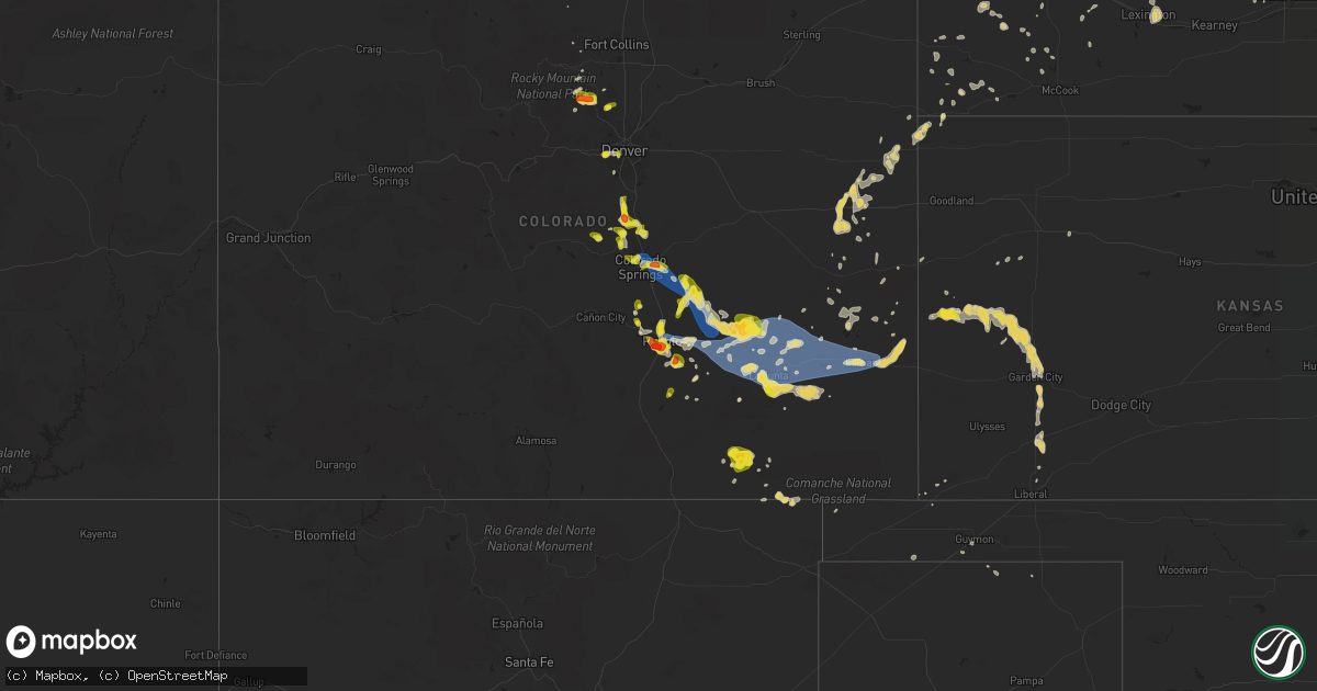
Hail Map on July 20, 2019
Get this storm
July 20 map
$229
one time, instant access
Download today. No call, no setup
Keep the $229
Bought the map and want the full workflow? Apply the entire $229 to a subscription within 7 days. None of it is wasted.
Every map, not just this one
This buys you this map. Subscription and you get every map we run, in the markets you choose from a few cities to whole states to nationwide. Plus real-time alerts the moment a storm fires.
Contact data
Name, contact info, occupancy, even credit band for addresses in the footprint. You go from where it hit to who to call.
Become the source they trust
Unlimited branding weather history reports on demand. You already have the documented answer ready for the property owner, and you are the one who showed up with it.
Property data and RoofTrace estimates
Pull up any address you have got, its value and the exact code rules for that jurisdiction, straight from One Click Code. Then RoofTrace estimates the squares, pitch, and roof value, priced the way you price.
States Impacted by Hail Map on July 20, 2019
Storm reports
West Virginia
| Date | Description |
|---|---|
| 07/20/20192:53 AM CDT | At 753 PM EDT, severe thunderstorms were located along a line extending from near Berryville to 6 miles west of Bluemont to 6 miles north of Linden, moving southeast at 20 mph. HAZARD...60 mph wind gusts and quarter size hail. SOURCE...Radar indicated. IMPACT...Damaging winds will cause some trees and large branches to fall. This could injure those outdoors, as well as damage homes and vehicles. Roadways may become blocked by downed trees. Localized power outages are possible. Unsecured light objects may become projectiles. Locations impacted include... Purcellville, Berryville, Middleburg, Round Hill, Bluemont, Hamilton, Saint Louis, Paeonian Springs, Gaylord, Rectortown, Wickliffe, Upperville, Philomont, Lincoln, Hughesville and Paris. |
Georgia
| Date | Description |
|---|---|
| 07/20/20196:45 PM CDT | Emergency manager reported a tree down on a house in the woodstock area. Damage unknown. Time estimated from radar. |
Ohio
| Date | Description |
|---|---|
| 07/20/20196:15 PM CDT | Tree down. Time estimated by radar. |
| 07/20/20193:30 AM CDT | At 830 PM EDT, a severe thunderstorm was located near Chardon, moving east at 25 mph. HAZARD...60 mph wind gusts. SOURCE...Radar indicated. IMPACT...Expect damage to trees and power lines. Locations impacted include... Chardon, Middlefield, North Bloomfield, Orwell, Burton, West Farmington, Bristolville, Chesterland, Huntsburg, Claridon, Hunting Valley and Aquilla. |
| 07/20/20193:23 AM CDT | At 822 AM EDT, a severe thunderstorm was located over Oakwood, or over New Castle, moving southeast at 35 mph. HAZARD...Wind gusts to 70 mph. SOURCE...Emergency management. IMPACT...Trees snapped and uprooted. Power outages can be expected. Locations impacted include... New Castle... Beaver Falls... Ellwood City... New Brighton... New Wilmington... Oakwood... New Castle Northwest... Patterson Township... Big Beaver... New Beaver... Pulaski... West Mayfield...This includes the following highways... Pennsylvania Turnpike between mile markers 5 and 19. Interstate 79 in Pennsylvania between mile markers 92 and 107. Interstate 376 in Pennsylvania between mile markers 5 and 33. |
| 07/20/20192:58 AM CDT | At 757 AM EDT, a severe thunderstorm was located over Farrell, or over Sharon, moving southeast at 30 mph. HAZARD...Wind gusts to 60 mph. SOURCE...Radar. IMPACT...Expect damage to trees and power lines, resulting in some power outages. Locations impacted include... New Castle... Hermitage... Sharon... Grove City... Sharpsville... Farrell... New Wilmington... Oakwood... New Castle Northwest... Pulaski... West Middlesex... Plain Grove Township...This includes the following highways... Interstate 79 in Pennsylvania between mile markers 109 and 116. Interstate 80 in Pennsylvania between mile markers 0 and 17. Interstate 376 in Pennsylvania between mile markers 4 and 13. |
| 07/20/20191:34 AM CDT | At 633 PM EDT, severe thunderstorms were located along a line extending from near Orwell to near Bristolville, moving east at 25 mph. HAZARD...60 mph wind gusts. SOURCE...Radar indicated. IMPACT...Expect damage to trees and power lines. Locations impacted include... Cortland, Kinsman, North Bloomfield, Orwell, Andover, West Farmington, Bristolville, Mecca, Johnston, Hartsgrove, Roaming Shores, Cherry Valley, Orangeville and Champion Heights. |
| 07/19/20199:03 PM CDT | Several trees down. |
| 07/19/20197:44 PM CDT | Tree down on wires. Time estimated from radar. |
| 07/19/20197:35 PM CDT | Tree on garage. Time estimated from radar. |
| 07/19/20197:34 PM CDT | Tree down. |
| 07/19/20197:30 PM CDT | Tree on house. Time estimated from radar. |
Vermont
| Date | Description |
|---|---|
| 07/20/20196:05 PM CDT | Tree down on power lines |
New Jersey
| Date | Description |
|---|---|
| 07/20/20196:10 PM CDT | Delayed report. Numerous trees and power lines down in the township. Time estimated from radar. |
| 07/20/20196:08 PM CDT | Several trees reported down blocking cr-519 near branchville. Time estimated from radar. |
Wisconsin
| Date | Description |
|---|---|
| 07/20/20192:07 PM CDT | Damage to grain and fertilizer bins... Multiple structures... And a tree uprooted. Time estimated by radar. |
| 07/20/20192:00 PM CDT | A local report indicates 60 MPH wind near 3 NE DODGEVILLE |
| 07/20/20191:25 PM CDT | Trees knocked down. Time estimated from radar. |
| 07/20/20191:10 PM CDT | Tree branches and power lines down. |
| 07/20/201912:54 PM CDT | Photos of trees down. Relayed via broadcast media. |
| 07/20/201912:39 PM CDT | Trees down across the county. Time estimated. |
| 07/20/201912:35 PM CDT | Large branches down. |
| 07/20/201912:18 PM CDT | Trees down. Time estimated. |
| 07/20/201912:15 PM CDT | Trees and wires down all across wrightstown. Time estimated. |
| 07/20/201912:15 PM CDT | Large tree down. |
| 07/20/201912:12 PM CDT | Trees down. Delayed report. Time estimated. |
| 07/20/201912:09 PM CDT | Tree moved a house off its foundation. Delayed report. Time estimated. |
| 07/20/201912:09 PM CDT | Trees down. Delayed report. Time estimated. |
| 07/20/201912:06 PM CDT | Tree down blocking the road. Time estimated. |
| 07/20/201912:05 PM CDT | Six to eight inch oak tree branch down on beech tree and west point road. Report via social media. |
| 07/20/201912:05 PM CDT | Trees down on highway q north of manitowoc |
| 07/20/201912:01 PM CDT | Trees down. Delayed report. Time estimated. |
| 07/20/201912:01 PM CDT | Numerous trees down across the county. Time estimated. |
| 07/20/201912:00 PM CDT | Downed trees on county highway q between lorenz and beagle streets. One tree about 13 inches in diameter down on a power line. Time estimated by radar. |
| 07/20/201912:00 PM CDT | Damage to retail store in plover. Glass doors blown in... Pipes fell from ceiling. |
| 07/20/201911:59 AM CDT | A local report indicates 59 MPH wind near GREEN BAY |
| 07/20/201911:45 AM CDT | Large tree branches down on garvey ave. Time estimated by radar. |
| 07/20/201911:44 AM CDT | Multiple large trees down. Located near the middle of the city. |
| 07/20/201911:43 AM CDT | Trees down. Time estimated. |
| 07/20/201911:37 AM CDT | Multiple trees down. Delayed report. Time estimated by radar. |
| 07/20/201911:36 AM CDT | Tornado on the ground near wrightstown. Loss of metal roofing on barn and loss of the top of a silo. Preliminary rating-ef0 |
| 07/20/201911:32 AM CDT | Trees and power lines down all over the place. Street flooding |
| 07/20/201911:32 AM CDT | Widespread trees down across the county. Time estimated. |
| 07/20/201911:31 AM CDT | A local report indicates 59 MPH wind near SHERWOOD |
| 07/20/201911:28 AM CDT | Tree limbs down |
| 07/20/201911:25 AM CDT | Measured gust at perkins and college avenue. |
| 07/20/201911:23 AM CDT | 2 trees uprooted and house damage. |
| 07/20/201911:23 AM CDT | Trees down. Delayed report. Time estimated. |
| 07/20/201911:22 AM CDT | A local report indicates 60 MPH wind near APPLETON |
| 07/20/201911:22 AM CDT | Tornado on the ground just northeast of greenville. Partial loss of roof covering and siding of house. Large tree limbs broken and power pole broken. Preliminary rating |
| 07/20/201911:20 AM CDT | A couple of road signs down over 441 southbound. Power pole bent over near 41 and ballard. A couple other road signs blown over and tree damage as well. |
| 07/20/201911:18 AM CDT | Tornado on the ground east of hortonville. 3 to 4 power poles snapped... Car port destroyed... 2 outbuildings partially damaged... Several trees snapped... Partial loss |
| 07/20/201911:15 AM CDT | Trees down on highway 34 and other areas. |
| 07/20/201911:10 AM CDT | Time estimated by radar. Numerous trees down within the town. Major damage reported. Many streets covered with downed trees and limbs. Power is out. |
| 07/20/201911:06 AM CDT | Trees down. Time estimated. |
| 07/20/201911:05 AM CDT | Large tree down... About one foot in diameter. |
| 07/20/201911:05 AM CDT | Tornado on the ground south of new london. Tornado crossed from waupaca into outagamie county. Trees and a few power poles snapped. Partial damage to siding and roofs. |
| 07/20/201911:01 AM CDT | A local report indicates 74 MPH wind near WAUSAU |
| 07/20/201911:01 AM CDT | Debris flying across road. Estimated 80 mph winds. |
| 07/20/201911:00 AM CDT | Weak tornado damaged a few trees south and southeast of weyauwega. |
| 07/20/201911:00 AM CDT | Trees down on homes... Roads... Wires across the town. Time estimated |
| 07/20/201910:57 AM CDT | Update to previous report. Roof damage to some buildings. Numerous trees down. |
| 07/20/201910:55 AM CDT | Tornado formed near waupaca airport and moved east-northeast to white lake. Damage to several buildings... Corn field... And trees. Rated ef0. |
| 07/20/201910:49 AM CDT | Trees down. Time estimated. |
| 07/20/201910:49 AM CDT | Reports of trees down |
| 07/20/201910:47 AM CDT | Large tree down on interstate 39 southbound lane about 8 miles north of stevens point. |
| 07/20/201910:46 AM CDT | Trees down. Estimated winds of 90 mph. |
| 07/20/201910:45 AM CDT | Near amherst. Trees down about 5 inches in diameter and blowing debris. |
| 07/20/201910:43 AM CDT | Lake dubay county park. Numerous trees down. Estimated winds of 70 mph. |
| 07/20/201910:40 AM CDT | Uprooted trees adn tree damage in trailer park on hayes avenue. Siding is off some trailers. |
| 07/20/201910:38 AM CDT | Trees down. Time estimated. |
| 07/20/201910:38 AM CDT | Trees down. All trees appear to have fallen in the same direction. Delayed report. Time estimated. |
| 07/20/201910:38 AM CDT | Reports of trees down in townships of finley and armenia |
| 07/20/201910:36 AM CDT | Lots of power lines down on fisher road |
| 07/20/201910:32 AM CDT | Trees and power lines down on highway 54 |
| 07/20/201910:30 AM CDT | Numerous tree limbs down and one tree down. Diameter larger than one foot. |
| 07/20/201910:29 AM CDT | Measured gusts at coop station plow3. Also reported on damage to menards in town and doors blown out of the store. |
| 07/20/201910:26 AM CDT | Many trees down at an apartment complex. Estimated about 1 foot in diameter. |
| 07/20/201910:26 AM CDT | Trees down in wisconsin rapids. One at canal street another at fisher street. |
| 07/20/201910:26 AM CDT | Sporadic down trees. |
| 07/20/201910:25 AM CDT | Branches down blocking the road on a residential street. Branches as big as 5 inches in diameter and 10 feet long. May be larger down the road. |
| 07/20/201910:12 AM CDT | 1 to 1.5 ft diameter tree down. Time estimated from radar. |
| 07/20/201910:11 AM CDT | A local report indicates 58 MPH wind near MARSHFIELD |
| 07/20/201910:11 AM CDT | Trees and power lines down on highway 54 |
| 07/20/201910:08 AM CDT | Very strong winds. Estimated 60 mph or greater. Some roof damage and many trees down. |
| 07/20/20199:58 AM CDT | Report of a semi truck blown off highway 10. |
| 07/20/20199:56 AM CDT | Reports of trees down along county road q between angelo and ft mccoy |
| 07/20/20199:49 AM CDT | Damage to area trees and power lines |
| 07/20/20199:48 AM CDT | Reports of trees down in various parts of county... Including some reports of fires. |
| 07/20/20199:47 AM CDT | Shingle damage to buildings on fort along with localized flooding |
| 07/20/20199:36 AM CDT | Numerous trees down between hatfield and neillsville. Time estimated from radar. |
| 07/20/20199:35 AM CDT | Trees knocked down |
| 07/20/20199:35 AM CDT | Reports of trees and power lines down in northern part of county. |
| 07/20/20199:34 AM CDT | Time estimated. Trees knocked down. |
| 07/20/20199:14 AM CDT | Tornado began in a small patch of woods near the intersection of west indies and isbell roads... With a discontinuous path noted over a ridge top before crossing highwa |
| 07/20/20199:10 AM CDT | Tornado began in a corn field just west of waller lane... With damage extending across highway 54. Tornado dissipated near a wooded area just east of sturh road. Damage |
| 07/20/20199:10 AM CDT | Large tree uprooted onto camper. |
| 07/20/20199:09 AM CDT | Trees reported down |
| 07/20/20199:00 AM CDT | Delayed report. Numerous reports of trees down. Time estimated from radar. |
| 07/20/20198:57 AM CDT | Delayed report. Multiple trees and branches down in galesville. Relayed via social media. Time estimated from radar. |
| 07/20/20198:54 AM CDT | *** 2 inj *** numerous reports of wind damage across trempealeau county... Including several structures damaged and widespread tree damage. One person sustained an inju |
| 07/20/20197:55 AM CDT | At 1254 PM CDT, severe thunderstorms were located along a line extending from 12 miles north of Egg Harbor to near Ephraim to 6 miles southeast of Jacksonport, moving northeast at 45 mph. HAZARD...60 mph wind gusts. SOURCE...Radar indicated. IMPACT...Expect damage to roofs, siding, and trees. Locations impacted include... Jacksonport, Ephraim, Newport State Park, Baileys Harbor, Sister Bay, Washington Island, Peninsula Center, Fish Creek, Peninsula State Park and Ellison Bay.This warning will extend the warning already in effect for Door County. |
| 07/20/20197:18 AM CDT | At 1217 PM CDT, severe thunderstorms were located along a line extending from near Sheboygan to near Columbus, moving southeast at 45 mph. HAZARD...60 mph wind gusts. SOURCE...Radar indicated. IMPACT...Expect damage to roofs, siding, and trees. Locations impacted include... Sheboygan, West Bend, Watertown, Mequon, Beaver Dam, Hartford, Grafton, Cedarburg, Waupun, Port Washington, Plymouth, Sheboygan Falls, Jackson, Mayville, Slinger, Columbus, Saukville, Bayside, Kewaskum and Horicon. |
| 07/20/20197:14 AM CDT | At 1213 PM CDT, severe thunderstorms were located along a line extending from near Bay Shore Park to 11 miles southeast of Two Creeks, moving northeast at 50 mph. HAZARD...70 mph wind gusts. SOURCE...Radar indicated. IMPACT...Expect considerable tree damage. Damage is likely to mobile homes, roofs, and outbuildings. These severe thunderstorms will remain over mainly rural areas of eastern Brown, Kewaunee and northeastern Manitowoc Counties, including the following locations... Krok, Maribel, Larrabee, Curran, Slovan, Gregorville, Rankin, Humboldt, Leo Frigo Bridge and Lincoln.This warning extends the severe thunderstorm warning already in effect for Brown, Kewaunee and Manitowoc Counties. |
| 07/20/20197:12 AM CDT | At 1212 PM CDT, severe thunderstorms were located along a line extending from 8 miles southeast of Lanesboro to Fredericksburg, moving east at 55 mph. HAZARD...70 mph wind gusts. SOURCE...Radar indicated. IMPACT...Expect considerable tree damage. Damage is likely to mobile homes, roofs, and outbuildings. Severe thunderstorms will be near... Waucoma around 1220 PM CDT. Hawkeye around 1225 PM CDT. West Union around 1235 PM CDT. Clermont around 1240 PM CDT. Elgin around 1245 PM CDT. Elkader around 1255 PM CDT. Farmersburg around 100 PM CDT. Garnavillo around 105 PM CDT.Other locations impacted by these severe thunderstorms includeVolney, County Roads A 52 And W 60, Festina, Nordness, Giard,Quandahl and Watson.People attending the Allamakee County Fair should seek safe shelterimmediately! |
| 07/20/20196:58 AM CDT | At 1157 AM CDT, severe thunderstorms were located along a line extending from near Bear Paw Scout Camp to near Gillett to 10 miles northeast of Pulaski to near Denmark to 10 miles northwest of Manitowoc, moving northeast at 55 mph. HAZARD...70 mph wind gusts. SOURCE...Radar indicated. IMPACT...Expect considerable tree damage. Damage is likely to mobile homes, roofs, and outbuildings. Severe thunderstorms will be near... Sturgeon Bay around 1225 PM CDT. Jacksonport and Egg Harbor around 1245 PM CDT. Ephraim around 1255 PM CDT. Newport State Park around 100 PM CDT.Other locations impacted by these severe thunderstorms includeBrussels, Peninsula Center, Fish Creek, Peninsula State Park, Valmy,Ellison Bay, Whitefish Bay, Shoemaker Point, Carlsville and Namur.Additional showers and thunderstorms can be expected before the mainstorm producing strong winds over 60 mph. |
| 07/20/20196:35 AM CDT | At 1135 AM CDT, severe thunderstorms were located along a line extending from near Keshena to near Navarino Wildlife Area to 9 miles west of Pulaski to 6 miles southeast of Kaukauna to Central Lake Winnebago, moving northeast at 55 mph. HAZARD...60 mph wind gusts and penny size hail. SOURCE...Radar indicated. IMPACT...Expect damage to roofs, siding, and trees. Severe thunderstorms will be near... Big Smokey Falls, Keshena and Legend Lake around 1140 AM CDT. Pulaski and South Branch around 1145 AM CDT. Gillett around 1150 AM CDT. Oconto around 1210 PM CDT.Other locations impacted by these severe thunderstorms includeCollege Of Menominee Nation, Lake Noseum, Cullen, Underhill, Breed,Sobieski, Upper Bass Lake, South Chase, Hayes and Pensaukee.People at Pulaski Community Park should seek safe shelterimmediately! |
| 07/20/20196:21 AM CDT | At 1119 AM CDT, severe thunderstorms were located along a line extending from 11 miles south of Neopit to Clintonville to 8 miles west of Black Creek to near Appleton to 8 miles northwest of Oshkosh to near Rush Lake, moving east at 55 mph. HAZARD...70 mph wind gusts and quarter size hail. SOURCE...Radar indicated. IMPACT...Hail damage to vehicles is expected. Expect considerable tree damage. Wind damage is also likely to mobile homes, roofs, and outbuildings. Severe thunderstorms will be near... Appleton and Menasha around 1125 AM CDT. Kaukauna, Little Chute, Kimberly, Black Creek, Navarino Wildlife Area and Darboy around 1130 AM CDT. Oshkosh around 1130 AM CDT. Shawano and Northern Lake Winnebago around 1135 AM CDT. High Cliff State Park around 1140 AM CDT. Pulaski around 1145 AM CDT. Green Bay, Brillion, Bellevue Town and Central Lake Winnebago around 1150 AM CDT. Denmark around 1155 AM CDT. Chilton around 1200 PM CDT.Other locations impacted by these severe thunderstorms includeWayside, Gregorville, Freedom, Whitcomb, Allenville, Frazer Corners,Metz, Buckbee, Uw Fox Valley and Dyckesville.People at Pulaski Community Park, Downtown Green Bay, Ford FestivalPark, and Experimental Aircraft Association Grounds should seek safeshelter immediately!This warning replaces the warning already in effect for portions of northeast Wisconsin. A tornado warning is also in effect until 1130 AM CDT for southeast Waupaca and western Outagamie Counties. |
| 07/20/20196:19 AM CDT | At 1119 AM CDT, severe thunderstorms were located along a line extending from 6 miles northeast of Goodhue to near Kasson, moving east at 70 mph. HAZARD...60 mph wind gusts. SOURCE...Radar indicated. IMPACT...Expect damage to roofs, siding, and trees. Severe thunderstorms will be near... Elgin around 1145 AM CDT. Plainview around 1150 AM CDT. Alma, Buffalo City and Kellogg around 1200 PM CDT.Other locations impacted by these severe thunderstorms include SouthTroy, Pioneer Campground, Rattelsnake Point, West Albany, CountyRoads 33 And 4, Rattlesnake Ridge and Bremen. |
| 07/20/20195:58 AM CDT | At 1057 AM CDT, a line of severe thunderstorm was located near Nerstrand, or near Northfield, moving east at 55 mph. these thunderstorms have a history of producing wind damage and gusts in excess of 60 mph. HAZARD...60 mph wind gusts and penny size hail. SOURCE...Radar indicated. IMPACT...Expect damage to roofs, siding, and trees. Locations impacted include... Faribault, Northfield, Red Wing, Cannon Falls, Ellsworth, Pine Island, Zumbrota, Kenyon, Dundas, Medford, Goodhue and Stanton.This includes the following highways... Interstate 35 between mile markers 45 and 53, and near mile marker72. U.S. Highway 61 between mile markers 82 and 104.This includes Treasure Island Casino. |
| 07/20/20195:49 AM CDT | At 1048 AM CDT, severe thunderstorms were located along a line extending from Chain O' Lakes-King to near Wautoma to Adams, moving east at 65 mph. HAZARD...60 mph wind gusts. SOURCE...Trained weather spotters. This line has a history of producing widespread wind damage across central Wisconsin. IMPACT...Expect damage to roofs, siding, and trees. Locations impacted include... Berlin, Montello, Westfield, Princeton, Green Lake, Lawrence, Packwaukee, Oxford, Neshkoro, Marquette, Glen Oak, Harrisville and Springfield Corners. |
| 07/20/20195:34 AM CDT | At 1033 AM CDT, severe thunderstorms were located along a line extending from 10 miles west of Rib Mountain to 9 miles south of Mosinee to near Whiting to near Plainfield to 10 miles southeast of New Rome, moving east at 60 mph. HAZARD...70 mph wind gusts and quarter size hail. SOURCE...Radar indicated. IMPACT...Hail damage to vehicles is expected. Expect considerable tree damage. Wind damage is also likely to mobile homes, roofs, and outbuildings. Severe thunderstorms will be near... Plainfield around 1040 AM CDT. Amherst around 1045 AM CDT. Weston and Hartman Creek State Park around 1050 AM CDT. Wautoma and Chain O' Lakes-King around 1055 AM CDT. Waupaca, Bevent and Napowan Scout Camp around 1100 AM CDT. Redgranite and Wittenberg around 1105 AM CDT. Fremont around 1110 AM CDT. New London and Lake Poygan around 1115 AM CDT. Oshkosh around 1130 AM CDT. Other locations impacted by these severe thunderstorms includePickett, Butte Des Morts, Big Eau Pleine County Park, Northport,Moon, Coddington, Borth, Fenwood, Kellner and Whitcomb.People at Ford Festival Park, and Experimental Aircraft AssociationGrounds should seek safe shelter immediately! |
| 07/20/20195:22 AM CDT | At 1021 AM CDT, severe thunderstorms were located along a line extending from near Lake Wazeecha to 8 miles south of New Rome to near New Lisbon, moving east at 50 mph. HAZARD...70 mph wind gusts and penny size hail. SOURCE...Radar indicated. IMPACT...Expect considerable tree damage. Damage is likely to mobile homes, roofs, and outbuildings. Severe thunderstorms will be near... New Rome around 1025 AM CDT. Dellwood around 1035 AM CDT. Friendship and Adams around 1045 AM CDT.Other locations impacted by these severe thunderstorms include NewMiner, Highways 13 And 21, County Roads G And O, County Roads G AndM, Johnson Hill, Jellystone Park Near Warrens and Highway 13 AndCounty E. |
| 07/20/20194:58 AM CDT | At 958 AM CDT, severe thunderstorms were located along a line extending from near Owen to 8 miles southeast of Shortville, moving east at 40 mph. HAZARD...60 mph wind gusts. SOURCE...Radar indicated. IMPACT...Expect damage to roofs, siding, and trees. These severe thunderstorms will remain over mainly rural areas of eastern Clark County, including the following locations... County K And Capital Road, Chili, Highway 73 And 98, Chili Corners, Atwood, Veefkind and Lynn. |
| 07/20/20194:51 AM CDT | At 951 AM CDT, severe thunderstorms were located along a line extending from 6 miles northeast of Neillsville to 7 miles southeast of Shortville to near Millston, moving east at 50 mph. HAZARD...60 mph wind gusts. SOURCE...Radar indicated. IMPACT...Expect damage to roofs, siding, and trees. Severe thunderstorms will be near... Marshfield and Pittsville around 1010 AM CDT. Wisconsin Rapids around 1025 AM CDT. Lake Wazeecha around 1030 AM CDT. Stevens Point and Whiting around 1045 AM CDT.Other locations impacted by these severe thunderstorms include NorthWood County Park, Big Eau Pleine County Park, Moon, Coddington,Blenker, Fenwood, Kellner, Ellis, Nelsonville and Powers Bluff CountyPark.People at Lake Wazeecha should seek safe shelter immediately! |
| 07/20/20194:22 AM CDT | At 922 AM CDT, severe thunderstorms were located along a line extending from 10 miles northwest of Black River Falls to West Salem, moving east at 45 mph. HAZARD...70 mph wind gusts and penny size hail. SOURCE...Radar indicated. IMPACT...Expect considerable tree damage. Damage is likely to mobile homes, roofs, and outbuildings. Severe thunderstorms will be near... Bangor around 930 AM CDT. Sparta and Black River Falls around 940 AM CDT. Hatfield around 945 AM CDT. Fort Mc Coy around 950 AM CDT. Tomah around 1000 AM CDT. New Lisbon around 1025 AM CDT. Mauston, Necedah and Dellwood around 1030 AM CDT.Other locations impacted by these severe thunderstorms include NewMiner, Franklin, Shamrock, Potters Flowage, Rockland.People attending the La Crosse Interstate Fair, and USSA Summerfestshould seek safe shelter immediately! |
| 07/20/20193:43 AM CDT | At 843 AM CDT, severe thunderstorms were located along a line extending from near Frontenac to Byron to near Hayfield, moving east at 45 mph. HAZARD...60 mph wind gusts. SOURCE...Radar indicated. IMPACT...Expect damage to roofs, siding, and trees. Severe thunderstorms will be near... Rochester around 855 AM CDT. Wabasha and Stewartville around 905 AM CDT. Eyota and Kellogg around 910 AM CDT. Dover around 915 AM CDT. Chatfield around 925 AM CDT.Other locations impacted by these severe thunderstorms include SouthTroy, County Roads 9 And 10, I 90 Exit 218, Potsdam, County Roads 6And 15, Hidden Meadows R V Park and Rock Dell. |
| 07/19/201910:55 PM CDT | At 354 PM CDT, severe thunderstorms were located along a line extending from Richmond to near Cherry Valley, moving east at 40 mph. HAZARD...60 mph wind gusts. SOURCE...Trained weather spotters. At 334 PM, tree limbs were reported down in Loves Park. IMPACT...Expect damage to roofs, siding, and trees. Locations impacted include... Rockford, Waukegan, Gurnee, Algonquin, McHenry, Belvidere, Woodstock, Zion, Loves Park, Machesney Park, Grayslake, Libertyville, Round Lake, Antioch, Beach Park, Wauconda, Fox Lake, Harvard, Lake Villa and Island Lake.This includes... Boone County Fairgrounds, Chain O Lakes State Park,College of Lake County, Lake County IL Fairgrounds, Mchenry CountyCollege, Mchenry County Fairgrounds, Moraine Hills State Park, RockCut State Park, Rock Valley College, Rockford Aviators Baseball,Rockford Speedway, Six Flags Great America, and Winnebago CountyFairgrounds. |
| 07/19/20199:44 PM CDT | At 243 PM CDT, severe thunderstorms were located along a line extending from near Scales Mound to near Nashville, moving east at 30 mph. HAZARD...60 mph wind gusts. SOURCE...Radar indicated. IMPACT...Expect damage to roofs, siding, and trees. Locations impacted include... Maquoketa, Mount Carroll, Savanna, Lena, Bellevue, Stockton, Warren, Preston, Hanover, Pearl City, Elizabeth, Cedarville, Woodbine, Sabula, Miles, Andrew, Scales Mound, Apple River, Winslow and Springbrook. |
| 07/19/20199:10 PM CDT | At 209 PM CDT, severe thunderstorms were located along a line extending from near Mazomanie to 6 miles northwest of Darlington, moving east at 45 mph. HAZARD...60 mph wind gusts. SOURCE...Emergency management. A 60 MPH wind gust was reported in the Dodgeville area. IMPACT...Expect damage to roofs, siding, and trees. Locations impacted include... Madison, Fitchburg, Middleton, Waunakee, Verona, Oregon, Monona, Mount Horeb, Windsor, Sauk City, Brodhead, Darlington, Deforest, Cross Plains, Belleville, New Glarus, Mazomanie, Shorewood Hills, Brooklyn and Black Earth.People attending The Dane County Fair in Madison should seek safeshelter immediately! |
| 07/19/20198:31 PM CDT | At 131 PM CDT, severe thunderstorms were located along a line extending from 7 miles south of Hillsboro to Sherrill, moving east at 65 mph. HAZARD...60 mph wind gusts. SOURCE...Trained weather spotters. Tree damage was reported across portions of far southwestern Wisconsin with this line. A 60 MPH wind gust was also measured. IMPACT...Expect damage to roofs, siding, and trees. Locations impacted include... Baraboo, Reedsburg, Dodgeville, Prairie Du Sac, Sauk City, Wisconsin Dells, Mineral Point, Darlington, Lake Delton, Spring Green, West Baraboo, Shullsburg, Belmont, Benton, Argyle, Blanchardville, Somers, Barneveld, Wiota and Highland.People attending The Baraboo Big Top Parade and Circus Celebrationshould seek safe shelter immediately! |
South Dakota
| Date | Description |
|---|---|
| 07/20/20198:35 AM CDT | Maximum wind gust measured at the canton mesonet site... Site id k7g9. |
| 07/20/20198:20 AM CDT | Wind split a large maple tree. |
| 07/20/20198:16 AM CDT | Asos station kfsd sioux falls airport. |
| 07/20/20198:10 AM CDT | Peak wind gust recorded at the kmhe asos. |
| 07/20/20198:07 AM CDT | Corrects previous tstm wnd gst report from 3 nnw sioux falls. Asos station kfsd joe foss field. |
| 07/20/20197:59 AM CDT | At 1258 AM MDT, a severe thunderstorm was located 9 miles south of Isabel, or 16 miles north of Lantry, moving east at 60 mph. HAZARD...60 mph wind gusts and quarter size hail. SOURCE...Radar indicated. IMPACT...Hail damage to vehicles is expected. Expect wind damage to roofs, siding, and trees. Locations impacted include... Timber Lake, Isabel, Firesteel, Tiospaye Topa School, Little Moreau Rec Area, Promise, White Horse, Bear Creek, Green Grass, Laplant, Glencross and Ridgeview. |
| 07/20/20197:59 AM CDT | Sddot rwis site. |
| 07/20/20197:59 AM CDT | Sddot rwis site. |
| 07/20/20197:57 AM CDT | Estimated 60-70 mph. |
| 07/20/20197:54 AM CDT | Sddot rwis site. |
| 07/20/20197:38 AM CDT | Metal roof panels on small apartment building ripped off. Time estimated from radar. |
| 07/20/20197:37 AM CDT | At 1236 AM MDT, a severe thunderstorm was located 9 miles northeast of Owl Butte, or 33 miles northeast of Sturgis, moving east at 50 mph. HAZARD...60 mph wind gusts and quarter size hail. SOURCE...Radar indicated. IMPACT...Hail damage to vehicles is expected. Expect wind damage to roofs, siding, and trees. Locations impacted include... Plainview, Fairpoint, Marcus, Stoneville, White Owl, Opal, Red Owl and Owl Butte. |
| 07/20/20197:34 AM CDT | At 1234 AM MDT, a severe thunderstorm was located 5 miles south of Glad Valley, or 21 miles northwest of Dupree, moving east at 50 mph. HAZARD...Golf ball size hail and 60 mph wind gusts. SOURCE...Radar indicated. IMPACT...People and animals outdoors will be injured. Expect hail damage to roofs, siding, windows, and vehicles. Expect wind damage to roofs, siding, and trees. Locations impacted include... Thunder Butte and Glad Valley. |
| 07/20/20197:33 AM CDT | Awos station kbkx brookings municipal airport. |
| 07/20/20197:32 AM CDT | Heavy damage to grain elevator in town. Report relayed via twitter. Time estimated from radar. |
| 07/20/20197:31 AM CDT | A local report indicates 66 MPH wind near 4 S SALEM |
| 07/20/20197:26 AM CDT | At 1226 AM MDT, a severe thunderstorm was located near Mud Butte, or 40 miles west of Faith, moving east at 35 mph. HAZARD...60 mph wind gusts and half dollar size hail. SOURCE...Radar indicated. IMPACT...Hail damage to vehicles is expected. Expect wind damage to roofs, siding, and trees. Locations impacted include... Opal, Usta, Maurine, Mud Butte and Zeona. |
| 07/20/20197:23 AM CDT | Four boats lifted off their racks along the south shore of lake madison. Time estimated from radar. |
| 07/20/20197:19 AM CDT | Measured on home weather station. |
| 07/20/20197:16 AM CDT | Extensive tree damage in the town. A tree fell onto power lines near the transformer... Causing power outages. Time estimated from radar. |
| 07/20/20197:15 AM CDT | 5-6 inch diameter tree branches down in the town. |
| 07/20/20197:14 AM CDT | Sddot rwis site. |
| 07/20/20197:00 AM CDT | A local report indicates 60 MPH wind near 6 NNW PLANKINTON |
| 07/20/20194:02 AM CDT | At 902 AM CDT, severe thunderstorms were located along a line extending from near Fulda to near Little Rock to near Ireton, moving east at 45 mph. HAZARD...60 mph wind gusts. SOURCE...Radar indicated. IMPACT...Expect damage to roofs, siding, and trees. Severe thunderstorms will be near... Sibley and Little Rock around 905 AM CDT. Orange City, Ocheyedan and Brewster around 920 AM CDT. Alton, Heron Lake and Round Lake around 925 AM CDT. Hospers, Granville and Harris around 930 AM CDT. Lake Park around 935 AM CDT. Lakefield around 940 AM CDT. Spirit Lake, Jackson In Jackson County, Milford, Arnolds Park, Paullina, Bergen, Okoboji, Orleans, Wahpeton and West Okoboji around 945 AM CDT.Other locations impacted by these severe thunderstorms includeMoneta, Calumet, Rossie, Alpha, Kinbrae, Okabena, Bigelow and Wilder. |
| 07/20/20193:39 AM CDT | At 839 AM CDT, severe thunderstorms were located along a line extending from near Rock Rapids to near Beresford, moving east at 50 mph. HAZARD...70 mph wind gusts. SOURCE...Radar indicated. IMPACT...Expect considerable tree damage. Damage is likely to mobile homes, roofs, and outbuildings. Severe thunderstorms will be near... Rock Rapids around 845 AM CDT. Hawarden, George and Hudson around 855 AM CDT. Little Rock around 900 AM CDT. Ireton around 905 AM CDT. Sioux Center and Sibley around 910 AM CDT.Other locations impacted by these severe thunderstorms includeBigelow. |
| 07/20/20193:15 AM CDT | At 815 AM CDT, a severe thunderstorm was located over Tea, or 9 miles southwest of Sioux Falls, moving east at 45 mph. HAZARD...70 mph wind gusts. SOURCE...Radar indicated. IMPACT...Expect considerable tree damage. Damage is likely to mobile homes, roofs, and outbuildings. This severe thunderstorm will be near... Harrisburg around 825 AM CDT. Lake Alvin State Recreation Area around 830 AM CDT. Rowena around 835 AM CDT. Larchwood around 840 AM CDT. Inwood, Lester and Alvord around 845 AM CDT.Other locations impacted by this severe thunderstorm include Steen. |
| 07/20/20192:48 AM CDT | At 748 AM CDT, severe thunderstorms were located along a line extending from near Forestburg to near Mitchell to near Dimock, moving east at 40 mph. HAZARD...60 mph wind gusts. SOURCE...Radar indicated. IMPACT...Expect damage to roofs, siding, and trees. Severe thunderstorms will be near... Alexandria, Artesian and Fulton around 800 AM CDT. Milltown, Fedora and Farmer around 810 AM CDT. Spencer In McCook County and Roswell around 815 AM CDT. Clayton around 820 AM CDT. Vilas around 825 AM CDT. Howard, Bridgewater and Canova around 830 AM CDT. |
| 07/20/20191:52 AM CDT | At 652 AM CDT, severe thunderstorms were located along a line extending from near Gann Valley to near White Lake to 9 miles west of Aurora Center, moving east at 35 mph. HAZARD...60 mph wind gusts. SOURCE...Radar indicated. IMPACT...Expect damage to roofs, siding, and trees. Severe thunderstorms will be near... White Lake around 700 AM CDT. Aurora Center around 710 AM CDT. Plankinton, Wessington Springs and Stickney around 720 AM CDT. |
| 07/20/20191:44 AM CDT | At 643 AM CDT, severe thunderstorms were located along a line extending from near Grass Lake to near De Smet, moving east at 40 mph. HAZARD...60 mph wind gusts and nickel size hail. SOURCE...Trained weather spotters. IMPACT...Expect damage to roofs, siding, and trees. Locations impacted include... Watertown, Clear Lake, Estelline, Castlewood, Lake Norden, Bryant, Hayti, Florence, Rauville, Henry, South Shore, Waverly, Kranzburg, Goodwin, Stockholm, Hazel, Wallace, Strandburg, Twin Brooks and La Bolt. |
| 07/20/20191:36 AM CDT | At 636 AM CDT, severe thunderstorms were located along a line extending from 8 miles south of Willow Lake to 6 miles north of Artesian to near Plankinton, moving east at 40 mph. HAZARD...70 mph wind gusts and quarter size hail. SOURCE...Radar indicated. IMPACT...Hail damage to vehicles is expected. Expect considerable tree damage. Wind damage is also likely to mobile homes, roofs, and outbuildings. Severe thunderstorms will be near... Artesian around 640 AM CDT. De Smet around 645 AM CDT. Carthage and Fedora around 650 AM CDT. Roswell around 655 AM CDT. Mitchell, Lake Preston and Loomis around 700 AM CDT. Howard and Vilas around 705 AM CDT. Badger and Hetland around 710 AM CDT. Winfred and Fulton around 715 AM CDT.Other locations impacted by these severe thunderstorms includeBancroft and Erwin. |
| 07/20/20191:29 AM CDT | At 628 AM CDT, a severe thunderstorm was located near Etbauer Hill, or 10 miles east of Fort Thompson, moving east at 40 mph. HAZARD...60 mph wind gusts. SOURCE...Radar indicated. IMPACT...Expect damage to roofs, siding, and trees. Locations impacted include... Shelby, Gann Valley, Lees Corner, Crow Creek Housing and Etbauer Hill. |
| 07/20/20191:22 AM CDT | At 621 AM CDT, severe thunderstorms were located along a line extending from near Crocker to 6 miles east of Yale, moving east at 40 mph. HAZARD...70 mph wind gusts and quarter size hail. SOURCE...Radar indicated. IMPACT...Hail damage to vehicles is expected. Expect considerable tree damage. Wind damage is also likely to mobile homes, roofs, and outbuildings. Locations impacted include... Clark, Bryant, Florence, Henry, Willow Lake, Hazel, Wallace, Bradley, Garden City, Vienna, Naples, Lily, Crocker, Medicine Lake, Mayfield Colony, Grass Lake, Kellerton Church, Swan Lake, Hillcrest Colony and Bitter Lake. |
| 07/20/201912:55 AM CDT | At 555 AM CDT, severe thunderstorms were located along a line extending from 7 miles west of Carpenter to near Alpena to 8 miles east of Chamberlain, moving east at 35 mph. HAZARD...60 mph wind gusts and penny size hail. SOURCE...Radar indicated. IMPACT...Expect damage to roofs, siding, and trees. Severe thunderstorms will be near... Alpena around 600 AM CDT. White Lake around 630 AM CDT. Plankinton and Carthage around 645 AM CDT.Other locations impacted by these severe thunderstorms includeBancroft, Broadland and Pukwana. |
| 07/20/201912:53 AM CDT | At 551 AM CDT, severe thunderstorms were located along a line extending from near Turton to near Hitchcock, moving east at 40 mph. HAZARD...60 mph wind gusts and quarter size hail. SOURCE...Radar indicated. IMPACT...Hail damage to vehicles is expected. Expect wind damage to roofs, siding, and trees. Locations impacted include... Clark, Willow Lake, Doland, Frankfort, Garden City, Raymond, Turton, Clark Colony, Spink Colony, Glendale Colony, Fordham Colony, Hillcrest Colony, Hillside Colony and Carpenter. |
| 07/20/201912:36 AM CDT | At 535 AM CDT, severe thunderstorms were located along a line extending from near Gann Valley to near Oacoma, moving east at 40 mph. HAZARD...60 mph wind gusts and penny size hail. SOURCE...Radar indicated. IMPACT...Expect damage to roofs, siding, and trees. These severe thunderstorms will remain over mainly rural areas of southwestern Jerauld and northern Brule Counties, including the following locations... Pukwana. |
| 07/20/201912:32 AM CDT | At 531 AM CDT, severe thunderstorms were located along a line extending from near Lake Sharpe to 11 miles southwest of 5 Mile Corner, moving east at 40 mph. HAZARD...60 mph wind gusts. SOURCE...Radar indicated. IMPACT...Expect damage to roofs, siding, and trees. Locations impacted include... Lower Brule, Presho, Fort Thompson, Lyman, Oacoma, Kennebec, Reliance, Vivian, Shelby, Cedar Creek Rec Area, Fate Dam, Medicine Butte, Earling Hills, Dude Ranch, Etbauer Hill, Lake Sharpe, Gann Valley, Lees Corner, Degrey Rec Area and West Bend Rec Area. |
| 07/20/201912:23 AM CDT | At 523 AM CDT, severe thunderstorms were located along a line extending from near Tulare to near Etbauer Hill, moving east at 40 mph. HAZARD...60 mph wind gusts and penny size hail. SOURCE...Radar indicated. IMPACT...Expect damage to roofs, siding, and trees. Severe thunderstorms will be near... Hitchcock around 540 AM CDT.Other locations impacted by these severe thunderstorms includeBroadland. |
| 07/20/201912:22 AM CDT | At 522 AM CDT, severe thunderstorms were located along a line extending from near Athol to 9 miles west of Pleasant Valley Country Church, moving east at 40 mph. HAZARD...60 mph wind gusts and quarter size hail. SOURCE...Radar indicated. IMPACT...Hail damage to vehicles is expected. Expect wind damage to roofs, siding, and trees. Locations impacted include... Redfield, Miller, Mellette, Tulare, St. Lawrence, Doland, Frankfort, Northville, Conde, Ashton, Hitchcock, Brentford, Athol, Burdette, Turton, Vayland, Rosehill Dam, Miller Dale Colony, Cottonwood Lake and Sunshine Bible Academy. |
| 07/19/201911:34 PM CDT | At 433 AM CDT/333 AM MDT/, severe thunderstorms were located along a line extending from 7 miles northeast of Holabird to near Harrold to near Degrey Rec Area to 9 miles north of Vivian to near Okaton, moving east at 30 mph. HAZARD...60 mph wind gusts and penny size hail. SOURCE...Radar indicated. IMPACT...Expect damage to roofs, siding, and trees. Locations impacted include... Lower Brule, Highmore, Presho, Murdo, Blunt, Vivian, Harrold, Draper, Ree Heights, Okaton, Westover, Cedar Creek Rec Area, Fate Dam, Rousseau, Joe Creek Rec Area, Canning, Holabird, Stephan, 5 Mile Corner and Lake Sharpe. |
| 07/19/201910:57 PM CDT | At 357 AM CDT, a severe thunderstorm was located over Cottonwood Lake Near Agar, or 10 miles northeast of Onida, moving east at 50 mph. HAZARD...60 mph wind gusts and penny size hail. SOURCE...Radar indicated. IMPACT...Expect damage to roofs, siding, and trees. Locations impacted include... Onida, Orient, Stone Lake and Cottonwood Lake Near Agar. |
| 07/19/201910:52 PM CDT | At 352 AM CDT, a severe thunderstorm was located over Lebanon, or 9 miles northeast of Gettysburg, moving east at 50 mph. HAZARD...60 mph wind gusts and penny size hail. SOURCE...Radar indicated. IMPACT...Expect damage to roofs, siding, and trees. Locations impacted include... Faulkton, Orient, Lebanon, Seneca, Tolstoy, Onaka, Burkmere, Brentwood Colony and Norbeck. |
| 07/19/201910:46 PM CDT | At 343 AM MDT, a severe thunderstorm was located 3 miles southeast of Howes, or 29 miles south of Faith, moving east at 50 mph. HAZARD...60 mph wind gusts and quarter size hail. SOURCE...Radar indicated. IMPACT...Hail damage to vehicles is expected. Expect wind damage to roofs, siding, and trees. Locations impacted include... Cherry Creek, Milesville, Bridger, Kirley, Howes, Billsburg and Takini School. |
| 07/19/20199:43 PM CDT | At 243 AM CDT/143 AM MDT/, a severe thunderstorm was located near Ridgeview, or 21 miles northeast of Eagle Butte, moving east at 50 mph. HAZARD...60 mph wind gusts and quarter size hail. SOURCE...Radar indicated. IMPACT...Hail damage to vehicles is expected. Expect wind damage to roofs, siding, and trees. Locations impacted include... Gettysburg, Lowry, Tiospaye Topa School, Swiftbird Day School, Swan Creek Rec Area, Swiftbird, Whitlocks Bay Rec Area, Laplant, Ridgeview and Lake Oahe. |
| 07/19/20199:36 PM CDT | At 235 AM CDT/135 AM MDT/, a severe thunderstorm was located 7 miles east of Tiospaye Topa School, or 25 miles south of Mobridge, moving east at 50 mph. HAZARD...60 mph wind gusts and quarter size hail. SOURCE...Radar indicated. IMPACT...Hail damage to vehicles is expected. Expect wind damage to roofs, siding, and trees. Locations impacted include... Hoven, Lebanon and Lake Oahe. |
| 07/19/20198:28 PM CDT | At 127 AM MDT, a severe thunderstorm was located 8 miles southeast of Durkee Lake, or 10 miles southeast of Faith, moving east at 40 mph. HAZARD...60 mph wind gusts and quarter size hail. SOURCE...Radar indicated. IMPACT...Hail damage to vehicles is expected. Expect wind damage to roofs, siding, and trees. Locations impacted include... Dupree, Faith, Cherry Creek, Milesville, Plainview, Enning, Opal, Marcus, South Eagle Butte, Bridger, Kirley, Howes, White Owl, Red Scaffold, Billsburg, Red Owl, Red Elm, Intersection of Cherry Creek and Sunnybrook Roads, Intersection of Highway 63 and BIA Road 8 and Durkee Lake. |
| 07/19/20198:09 PM CDT | At 109 AM MDT, a severe thunderstorm was located 3 miles south of Iron Lightning, or 11 miles northeast of Faith, moving east at 45 mph. HAZARD...60 mph wind gusts and quarter size hail. SOURCE...Radar indicated. IMPACT...Hail damage to vehicles is expected. Expect wind damage to roofs, siding, and trees. Locations impacted include... Dupree, Faith, Thunder Butte, Red Elm, Iron Lightning, Durkee Lake and Arrow Head Buttes. |
Colorado
| Date | Description |
|---|---|
| 07/20/20196:44 PM CDT | Reported by the centennial airport asos. |
| 07/20/20196:20 PM CDT | A local report indicates 62 MPH wind near 5 NE BLENDE |
| 07/20/20196:15 PM CDT | Live tree downed over road. |
| 07/20/20196:06 PM CDT | Few trees down. |
| 07/20/20196:03 PM CDT | A local report indicates 1.00 inch wind near 2 WNW BLENDE |
| 07/20/20196:00 PM CDT | A local report indicates 1.00 inch wind near 5 WSW BLENDE |
| 07/20/20195:58 PM CDT | Heavy rain and strong winds. |
| 07/20/20195:57 PM CDT | A local report indicates 1.00 inch wind near 2 WNW BLENDE |
| 07/20/20195:55 PM CDT | A local report indicates 1.00 inch wind near 5 WSW BLENDE |
| 07/20/20195:52 PM CDT | A local report indicates 1.00 inch wind near 1 S PUEBLO WEST |
| 07/20/20195:52 PM CDT | A local report indicates 1.25 inch wind near 4 ESE PUEBLO RESERVOIR |
| 07/20/20195:47 PM CDT | A local report indicates 1.00 inch wind near 5 ESE PUEBLO RESERVOIR |
| 07/20/20195:45 PM CDT | Hail size 1.1 inches... 24 hour rainfall total of 0.92 inches. |
| 07/20/20195:37 PM CDT | Asos station kcos colorado springs airport. |
| 07/20/20195:30 PM CDT | A local report indicates 1.00 inch wind near 3 N COLORADO SPRINGS |
| 07/20/20195:30 PM CDT | A local report indicates 59 MPH wind near 1 SSE PETERSON AFB |
| 07/20/20195:25 PM CDT | 2 inch tree branches down. |
| 07/20/20193:53 AM CDT | At 853 PM MDT, a severe thunderstorm was located near Neenoshe Reservoir, or 20 miles north of Lamar, moving east at 55 mph. HAZARD...60 mph wind gusts and nickel size hail. SOURCE...Radar indicated. IMPACT...Expect damage to roofs, siding, and trees. Locations impacted include... Eads, Sheridan Lake, Towner, Sweetwater Reservoir, Chivington, Brandon, Neenoshe Reservoir, Neegronda Reservoir and Queens Reservoir. |
| 07/20/20193:41 AM CDT | At 841 PM MDT, a severe thunderstorm was located over Bristol, or 16 miles west of Coolidge, moving east at 30 mph. HAZARD...70 mph wind gusts and ping pong ball size hail. SOURCE...Radar indicated. IMPACT...People and animals outdoors will be injured. Expect hail damage to roofs, siding, windows, and vehicles. Expect considerable tree damage. Wind damage is also likely to mobile homes, roofs, and outbuildings. Locations impacted include... Holly, Granada, Hartman and Bristol. |
| 07/20/20193:08 AM CDT | At 807 PM MDT, a severe thunderstorm was located over Lamar, moving east at 30 mph. HAZARD...70 mph wind gusts and quarter size hail. SOURCE...Radar indicated. IMPACT...Hail damage to vehicles is expected. Expect considerable tree damage. Wind damage is also likely to mobile homes, roofs, and outbuildings.These storms have had a long history of producing severe weather as they have moved east across the southeast Colorado Plains. Locations impacted include... Lamar, Holly, Granada, Wiley, Hartman, McClave and Bristol. |
| 07/20/20192:41 AM CDT | At 740 PM MDT, a severe thunderstorm was located 14 miles south of John Martin Reservoir, or 23 miles southwest of Lamar, moving east at 35 mph. This cluster of thunderstorms has a long history of producing wind damage. HAZARD...70 mph wind gusts and quarter size hail. SOURCE...Radar indicated. IMPACT...Hail damage to vehicles is expected. Expect considerable tree damage. Wind damage is also likely to mobile homes, roofs, and outbuildings. Locations impacted include... Lamar, Las Animas, Wiley, McClave, Hasty, John Martin Reservoir, Fort Lyon and Caddoa. |
| 07/20/20192:17 AM CDT | At 716 PM MDT, a severe thunderstorm was located near Las Animas, or 11 miles east of North La Junta, moving east at 30 mph. HAZARD...70 mph wind gusts and half dollar size hail. SOURCE...Radar indicated. IMPACT...Hail damage to vehicles is expected. Expect considerable tree damage. Wind damage is also likely to mobile homes, roofs, and outbuildings. Locations impacted include... Lamar, Las Animas, Eads, Wiley, Haswell, McClave, Higbee, Blue Lake, Sweetwater Reservoir, Hasty, Neenoshe Reservoir, Neegronda Reservoir, Arlington, Queens Reservoir, John Martin Reservoir, Caddoa and Fort Lyon. |
| 07/20/20191:10 AM CDT | At 610 PM MDT, a severe thunderstorm was located 8 miles north of Crowley, or 29 miles northwest of La Junta, moving east at 50 mph. HAZARD...60 mph wind gusts and quarter size hail. SOURCE...Radar indicated. IMPACT...Hail damage to vehicles is expected. Expect wind damage to roofs, siding, and trees. Locations impacted include... La Junta, North La Junta, Rocky Ford, Las Animas, Fowler, Ordway, Swink, Manzanola, Olney Springs, Sugar City, Cheraw, Crowley, Higbee, Blue Lake, Timpas, Arlington, John Martin Reservoir and Fort Lyon. |
| 07/20/201912:52 AM CDT | At 551 PM MDT, a severe thunderstorm was located 14 miles south of Truckton, or 32 miles northeast of Pueblo, moving southeast at 30 mph. HAZARD...70 mph wind gusts. SOURCE...Radar indicated. IMPACT...Expect considerable tree damage. Damage is likely to mobile homes, roofs, and outbuildings. This severe thunderstorm will remain over mainly rural areas of southwestern Lincoln County. |
| 07/20/201912:17 AM CDT | At 516 PM MDT, a severe thunderstorm was located 8 miles southeast of Hanover, or 27 miles northeast of Pueblo, moving southeast at 20 mph. HAZARD...70 mph wind gusts and half dollar size hail. SOURCE...Radar indicated. IMPACT...Hail damage to vehicles is expected. Expect considerable tree damage. Wind damage is also likely to mobile homes, roofs, and outbuildings. Locations impacted include... Fowler, Manzanola, Olney Springs, Boone, Crowley, Hanover, Truckton, Schriever AFB and Pueblo Depot. |
| 07/20/201912:08 AM CDT | At 506 PM MDT, a severe thunderstorm was located near Pueblo, moving northwest at 20 mph. Other strong to severe storms were also noted in northwest Pueblo county. This storm has a history of producing ping pong size hail. HAZARD...Golf ball size hail and 70 mph wind gusts. SOURCE...Radar indicated. IMPACT...People and animals outdoors will be injured. Expect hail damage to roofs, siding, windows, and vehicles. Expect considerable tree damage. Wind damage is also likely to mobile homes, roofs, and outbuildings. Locations impacted include... Pueblo, Boone, Pueblo Reservoir, Salt Creek, Blende, Avondale, Pueblo West, Pueblo Depot and Pinon. |
| 07/19/201911:56 PM CDT | At 455 PM MDT, a severe thunderstorm was located over southeastern Colorado Springs, moving southeast at 25 mph. HAZARD...70 mph wind gusts and half dollar size hail. This storm has a long history of producing damaging winds and large hail. SOURCE...Radar indicated. IMPACT...Hail damage to vehicles is expected. Expect considerable tree damage. Wind damage is also likely to mobile homes, roofs, and outbuildings. Locations impacted include... Colorado Springs, Fountain, Hanover, Stratmoor, Schriever AFB, Fort Carson, Security, Peterson AFB, Security-Widefield and Cimarron Hills. |
| 07/19/201911:39 PM CDT | At 439 PM MDT, a severe thunderstorm was located over Salt Creek, or near Pueblo, moving northwest at 15 mph. Other severe storms were oted over northern side of Pueblo West. HAZARD...70 mph wind gusts and quarter size hail. SOURCE...Radar indicated. IMPACT...Hail damage to vehicles is expected. Expect considerable tree damage. Wind damage is also likely to mobile homes, roofs, and outbuildings. Locations impacted include... Pueblo, Pueblo Reservoir, Salt Creek, Blende, Pueblo West, Pinon, Avondale, Pueblo Depot and Penrose. |
| 07/19/201911:37 PM CDT | At 437 PM MDT, a severe thunderstorm was located over southern Colorado Springs, moving southeast at 20 mph. HAZARD...70 mph wind gusts and quarter size hail. SOURCE...Radar indicated. IMPACT...Hail damage to vehicles is expected. Expect considerable tree damage. Wind damage is also likely to mobile homes, roofs, and outbuildings. Locations impacted include... Colorado Springs, Fountain, Air Force Academy, Manitou Springs, Ellicott, Schriever AFB, Security, Falcon, Security-Widefield, Stratmoor, Fort Carson, Peterson AFB, Cimarron Hills and Hanover. |
| 07/19/201911:24 PM CDT | At 424 PM MDT, a severe thunderstorm was located over northwestern Colorado Springs, moving northeast at 25 mph. HAZARD...70 mph wind gusts and quarter size hail. SOURCE...Radar indicated. IMPACT...Hail damage to vehicles is expected. Expect considerable tree damage. Wind damage is also likely to mobile homes, roofs, and outbuildings. Locations impacted include... Colorado Springs, Air Force Academy, Manitou Springs, Black Forest, Peyton, Gleneagle, Falcon and Cimarron Hills. |
| 07/19/201910:13 PM CDT | At 312 PM MDT, a severe thunderstorm was located near Jamestown, or 31 miles northwest of Denver, moving southeast at 5 mph. HAZARD...Ping pong ball size hail and 60 mph wind gusts. SOURCE...Radar indicated. IMPACT...Expect damage to roofs, siding, and trees. People and animals outdoors will be injured. Expect hail damage to roofs, siding, windows, and vehicles. Locations impacted include... Northern Boulder, Jamestown, Salina, Gold Hill, Sunshine, Summerville and Niwot. |
| 07/19/201910:05 PM CDT | At 305 PM MDT, a severe thunderstorm was located over northeastern Littleton, or 8 miles south of Denver, moving east at 15 mph. HAZARD...60 mph wind gusts and half dollar size hail. SOURCE...Radar indicated. IMPACT...Expect damage to roofs, siding, and trees. Hail damage to vehicles is expected. Locations impacted include... Denver, western Aurora, eastern Lakewood, Centennial, Highlands Ranch, southwestern Commerce City, Littleton, Englewood, southeastern Wheat Ridge, Greenwood Village, Lone Tree, Roxborough Park, Sheridan and Chatfield Reservoir. |
| 07/19/201910:05 PM CDT | At 305 PM MDT, a severe thunderstorm was located near Westcreek, or 28 miles northwest of Colorado Springs, moving northeast at 5 mph. HAZARD...60 mph wind gusts and quarter size hail. SOURCE...Radar indicated. IMPACT...Hail damage to vehicles is expected. Expect wind damage to roofs, siding, and trees. This severe thunderstorm will remain over mainly rural areas of northwestern Teller and northwestern El Paso Counties. |
| 07/19/201910:03 PM CDT | At 303 PM MDT, a severe thunderstorm was located near Perry Park, or 30 miles south of Denver, moving southeast at 15 mph. HAZARD...Ping pong ball size hail and 60 mph wind gusts. SOURCE...Radar indicated. IMPACT...Expect damage to roofs, siding, and trees. People and animals outdoors will be injured. Expect hail damage to roofs, siding, windows, and vehicles. Locations impacted include... Castle Rock, Larkspur, Perry Park, Franktown, Greenland, Sedalia, The Pinery and southeastern Castle Pines. |
| 07/19/20199:36 PM CDT | At 236 PM MDT, a severe thunderstorm was located near Jamestown, or 32 miles southwest of Fort Collins, moving southeast at 10 mph. HAZARD...60 mph wind gusts and half dollar size hail. SOURCE...Radar indicated. IMPACT...Expect damage to roofs, siding, and trees. Hail damage to vehicles is expected. Locations impacted include... Boulder, southwestern Longmont, Lyons, Jamestown, Wallstreet, Salina, Crisman, Gold Hill, Sunshine, Summerville and Niwot. |
| 07/19/20198:27 PM CDT | Extensive tree debris through town. Estimated size of branches up to 8 inches in diameter. |
| 07/19/20197:58 PM CDT | Asos station klhx la junta airport. |
Pennsylvania
| Date | Description |
|---|---|
| 07/20/20196:25 PM CDT | Photos of a very large tree down on both a garage and crushing a pickup truck posted to local media outlet facebook page. |
| 07/20/20197:25 AM CDT | Tree down along savannah road in shenango twp. |
| 07/20/20197:24 AM CDT | Tree and power lines down in neshannock twp. |
| 07/20/20197:22 AM CDT | Tree on residence along tony st. |
| 07/20/20197:20 AM CDT | Reports of tree and wires down in city of new castle |
| 07/20/20197:18 AM CDT | Tree and wires down in neshannok twp. |
| 07/20/20197:18 AM CDT | Tree down along ashberry lane in neshannock twp |
| 07/20/20197:15 AM CDT | Tree down along glen road in neshannock twp |
| 07/20/20197:06 AM CDT | Power lines down along sr 551 in pulaski twp. |
| 07/20/20197:05 AM CDT | Tree down in pulaski twp |
| 07/20/20195:25 AM CDT | At 1024 PM EDT, a severe thunderstorm was located 9 miles north of Clarion, moving east at 15 mph. HAZARD...Wind gusts to 60 mph. SOURCE...Radar. IMPACT...Expect damage to trees and power lines, resulting in some power outages. Locations impacted include... Shippenville... Sigel... Fryburg... Fisher... Leeper... Clarington... Clear Creek State Park... Cook Forest State Park... |
| 07/20/20194:56 AM CDT | At 955 PM EDT, a severe thunderstorm was located 8 miles northwest of Knox, moving east at 15 mph. HAZARD...Wind gusts to 60 mph. SOURCE...Radar. IMPACT...Damage to trees and power lines. Locations impacted include... Oil City... Sugarcreek... Seneca... Shippenville... Woodland Heights... Fryburg... Cranberry Township... |
| 07/20/20194:46 AM CDT | At 945 PM EDT, a severe thunderstorm was located over Geneva-On-The-Lake, moving east at 40 mph. HAZARD...60 mph wind gusts. SOURCE...Radar indicated. IMPACT...Expect damage to trees and power lines. Locations impacted include... Ashtabula, Conneaut, Geneva-On-The-Lake, Geneva, Madison, Girard, North Kingsville, Albion, Lake City, Austinburg, Kingsville, Pierpont, North Perry, Conneautville, Cranesville, Springboro, Platea, Edgewood, Plymouth Center and North Madison. |
| 07/20/20192:23 AM CDT | At 722 PM EDT, a severe thunderstorm was located 8 miles southwest of Ligonier, or 12 miles south of Latrobe, moving east at 15 mph. HAZARD...Wind gusts to 60 mph. SOURCE...Radar. IMPACT...Damage to trees and power lines. Locations impacted include... Laurel Mountain... Donegal... Acme... Laurel Mountain State Park... Jones Mills... This includes Pennsylvania Turnpike between mile markers 82 and 99. |
| 07/20/20191:54 AM CDT | At 654 PM EDT, a severe thunderstorm was located near Branchville, or 8 miles southeast of Montague, moving east at 15 mph. HAZARD...60 mph wind gusts. SOURCE...Radar indicated. IMPACT...Damage to roofs, siding, trees, and power lines is possible. Locations impacted include... Port Jervis, Montague, Franklin, Hamburg, Ogdensburg, Sussex, Branchville, High Point, Pellettown, Crandon Lakes and Hainesville. |
| 07/19/20199:45 PM CDT | A few trees down |
| 07/19/20199:30 PM CDT | Report of multiple trees and wires down on route 36 between miola road and route 66 and then from route 66 to the tykersburg cutoff. |
| 07/19/20199:15 PM CDT | Several trees reported down on wires. Davis and fertigs road... Tarklin and mapleshade road... Camp coffman road... Pinegrove school road and hale road. |
Illinois
| Date | Description |
|---|---|
| 07/20/20194:36 PM CDT | Half of large tree downed. Reported at randall rd and huntley rd. |
| 07/20/20194:20 PM CDT | Photo relayed via social media shows tree down on a house. Time estimated via radar. |
| 07/20/20194:17 PM CDT | Large tree downed. |
| 07/20/20194:10 PM CDT | Large tree down blocking derby line rd. Relayed via social media. Time estimated via radar. |
| 07/20/20194:05 PM CDT | Trees down. Time estimated via radar. |
| 07/20/20194:00 PM CDT | Trees down. Time estimated via radar. |
| 07/20/20193:47 PM CDT | Large tree approximately two feet in diameter snapped near the base. Tree appeared at least somewhat rotted. |
| 07/20/20193:45 PM CDT | 5-inch diameter and 30 foot long tree branch down. Time estimated via radar. |
| 07/20/20193:34 PM CDT | Corrects previous tstm wnd dmg report from loves park. Small branches down. In addition... Images shared show a few larger tree limbs down. |
| 07/20/20193:30 PM CDT | Multiple tree limbs... Some large... Blown down. Relayed via social media. |
| 07/20/20192:55 PM CDT | A couple of trees down at the apple river canyon state park. Time estimated by radar. |
| 07/19/201911:35 PM CDT | At 434 PM CDT, severe thunderstorms were located along a line extending from Green Oaks to near Barrington, moving east northeast at 40 mph. HAZARD...60 mph wind gusts and nickel size hail. SOURCE...Radar indicated. IMPACT...Expect damage to roofs, siding, and trees. Locations impacted include... Elgin, Waukegan, Arlington Heights, Schaumburg, Palatine, Des Plaines, Mount Prospect, Hoffman Estates, Glenview, Buffalo Grove, Carpentersville, Wheeling, Northbrook, North Chicago, Gurnee, Mundelein, Algonquin, Highland Park, Wilmette and Vernon Hills.This includes... Oakton Community College, Elgin Community College,Great Lakes Naval Training Center, Harper College, Lake ForestCollege, and Ravinia Music Festival. |
| 07/19/201911:25 PM CDT | At 424 PM CDT, a severe thunderstorm was located over Palatine and Arlington Heights, moving east at 25 mph. HAZARD...60 mph wind gusts and penny size hail. SOURCE...Radar indicated. IMPACT...Expect damage to roofs, siding, and trees. Locations impacted include... Arlington Heights, Schaumburg, Palatine, Mount Prospect, Glenview, Buffalo Grove, Wheeling, Northbrook, Highland Park, Wilmette, Vernon Hills, Rolling Meadows, Lake Forest, Deerfield, Winnetka, Glencoe, Long Grove, Lincolnshire, Riverwoods and Prospect Heights.Including the following interstates... I-94 between mile markers 21 and 34. I-294 between mile markers 21 and 34.This includes... Ravinia Music Festival. |
Minnesota
| Date | Description |
|---|---|
| 07/20/201912:12 PM CDT | Report of trees down |
| 07/20/201911:42 AM CDT | Via personal weather station near century hills. Power outages. |
| 07/20/201911:38 AM CDT | Asos station krst rochester international airport. |
| 07/20/201911:34 AM CDT | A local report indicates 64 MPH wind near ROCHESTER AIRPORT |
| 07/20/201911:32 AM CDT | A local report indicates 60 MPH wind near 1 NW ROCHESTER |
| 07/20/201911:32 AM CDT | Social media photo of large portion of tree down. Relayed via broadcast media. Time estimated from radar. |
| 07/20/201911:30 AM CDT | 2-4 inch branches down. Picture on facebook. |
| 07/20/201911:24 AM CDT | Large tree down in northwest austin. Social media photo relayed by broadcast media. |
| 07/20/201911:24 AM CDT | Tree uprooted. Relayed via broadcast media. Time estimated from radar. |
| 07/20/201911:24 AM CDT | Numerous trees reported down in town |
| 07/20/201911:22 AM CDT | Social media photos of trees down. Relayed via broadcast media. |
| 07/20/201911:20 AM CDT | A local report indicates 58 MPH wind near 2 W DODGE CENTER |
| 07/20/201911:16 AM CDT | Several 6 inch branches down across town. |
| 07/20/201911:15 AM CDT | Large tree uprooted and power lines down in east park. Time estimated from radar. |
| 07/20/201911:15 AM CDT | Trees down around the fairgrounds... Time estimated. |
| 07/20/201911:15 AM CDT | Tree uprooted at owatonna country club. Time estimated. |
| 07/20/201911:05 AM CDT | Widespread tree damage... Roof damage to commercial building. Time estimated from radar. |
| 07/20/201911:01 AM CDT | A local report indicates 60 MPH wind near 1 N HAYWARD |
| 07/20/201911:00 AM CDT | Large tree branches down. |
| 07/20/201911:00 AM CDT | Several trees and branches down. Pictures via facebook. |
| 07/20/201911:00 AM CDT | Large tree snapped at base. Time estimated. |
| 07/20/201911:00 AM CDT | A local report indicates 60 MPH wind near BAYPORT |
| 07/20/201911:00 AM CDT | 6 inch branch down... Other smaller branches also down. |
| 07/20/201911:00 AM CDT | Medium to large branches down and estimated 50-60mph gusts. |
| 07/20/201910:51 AM CDT | 12 to 16 inch diameter limb broken off on southwest corner of county road 45 and 250 st. Noted that much of the cornfield visible from 45 was laid over in that area. Ab |
| 07/20/201910:50 AM CDT | Multiple trees down across town. |
| 07/20/201910:45 AM CDT | Spotter reports large tree branches down in and around waldorf. |
| 07/20/201910:38 AM CDT | Multiple trees down across town. |
| 07/20/201910:30 AM CDT | 4 inch diameter branches down. |
| 07/20/201910:15 AM CDT | Pine tree uprooted and large branches down. |
| 07/20/201910:04 AM CDT | Awos station kfrm fairmont ap. |
| 07/20/20199:55 AM CDT | Spotter estimates gusts to around 60mph... Power knocked out in st. James area. |
| 07/20/20199:49 AM CDT | Tree branches down in woodbury. Gust recorded via home weather station. |
| 07/20/20199:37 AM CDT | Awos station kmwm windom municipal airport. |
| 07/20/20199:30 AM CDT | Lakefield rwis station. |
| 07/20/20199:15 AM CDT | Mesonet station mn038 dovray mn-30 mile post 49. |
| 07/20/20199:13 AM CDT | Rwis station. |
| 07/20/20199:00 AM CDT | Mature oak tree down across 57th ave... Snapped off 8ft from base. |
| 07/20/20199:00 AM CDT | Mesonet station mn007 i-90 mile post 35. |
| 07/20/20198:57 AM CDT | Asos station krst rochester international airport. |
| 07/20/20198:57 AM CDT | Reports of trees and power lines down in town |
| 07/20/20198:45 AM CDT | 50 foot tree fell on a deck in rural north side of rochester. |
| 07/20/20198:35 AM CDT | Mesonet station mn006 beaver creek i-90 mile post 4. |
| 07/20/20198:30 AM CDT | Asos station kmic crystal ap. |
| 07/20/20198:30 AM CDT | Large tree... Branches down on top of vehicle... Roof. Pictures on facebook. |
| 07/20/20198:12 AM CDT | Pipestone raws station. Time estimated from radar. |
| 07/20/20196:16 AM CDT | At 1116 AM CDT, severe thunderstorms were located along a line extending from near London to 8 miles southeast of Garner, moving east at 50 mph. HAZARD...60 mph wind gusts. SOURCE...Radar indicated. IMPACT...Expect damage to roofs, siding, and trees. Severe thunderstorms will be near... Lyle around 1125 AM CDT. Stacyville around 1135 AM CDT. Rockford around 1150 AM CDT. Marble Rock around 1155 AM CDT. Nashua around 1215 PM CDT.Other locations impacted by these severe thunderstorms include CountyRoads A 39 And S 70, Meyer, Toeterville, County Roads B 60 And T 18,Rock Creek, Idlewilde State Park and Otranto. |
| 07/20/20196:04 AM CDT | At 1104 AM CDT, severe thunderstorms were located along a line extending from near Glenville to 8 miles northwest of Belmond, moving east at 85 mph. HAZARD...60 mph wind gusts. SOURCE...Radar indicated. At around 1100am tree damage and 60 mph winds were reported in Forest City. IMPACT...Expect damage to roofs, siding, and trees. Locations impacted include... Mason City, Forest City, Garner, Northwood, Lake Mills, Manly, Rockwell, Emmons, Clear Lake, Eagle Lake, Mason City Municipal Airport, Rice Lake, Ventura, Kanawha, Klemme, Thornton, Plymouth, Fertile, Leland and Kensett.This includes Interstate 35 between mile markers 178 and 218. |
| 07/20/20195:56 AM CDT | At 1053 AM CDT, severe thunderstorms were located along a line extending from near Faribault to Emmons, moving east at 70 mph. HAZARD...60 mph wind gusts and penny size hail. SOURCE...Radar indicated. This storm has a hisotory of producing 60 to 65 mph wind gusts. IMPACT...Expect damage to roofs, siding, and trees. Severe thunderstorms will be near... Lyle around 1115 AM CDT. Rose Creek around 1120 AM CDT. Oronoco and Adams around 1125 AM CDT. Le Roy around 1135 AM CDT.Other locations impacted by these severe thunderstorms include I 90Exit 218, Eden, Highway 57 And 570th Street, County Roads 6 And 15,Hidden Meadows R V Park, Rock Dell and Brookside Campground.Those attending the Dodge County Fair are in the path of these storms and should prepare for damaging winds. SEEK SHELTER NOW! |
| 07/20/20195:34 AM CDT | At 1033 AM CDT, a severe thunderstorm was located near Janesville, or 12 miles southeast of Mankato, moving east at 55 mph. This storm has a history of producing wind gusts in excess of 60 mph. HAZARD...60 mph wind gusts. SOURCE...Radar indicated. IMPACT...Expect damage to roofs, siding, and trees. Locations impacted include... Owatonna, Faribault, Waseca, Janesville, Blooming Prairie, Waterville, Medford, New Richland, Madison Lake, Morristown, Ellendale and Elysian.This includes the following highways... Interstate 35 between mile markers 26 and 59. U.S. Highway 14 between mile markers 142 and 182. |
| 07/20/20195:15 AM CDT | At 1014 AM CDT, severe thunderstorms were located along a line extending from near Iowa Lake to 6 miles east of Five Island Lake to near Albert City, moving east at 55 mph. HAZARD...60 mph wind gusts. SOURCE...Radar indicated. At 1001am a 64 mph wind gust was reported at the Estherville airport. IMPACT...Expect damage to roofs, siding, and trees. Locations impacted include... Algona, Pocahontas, Laurens, Union Slogh, West Bend, Bancroft, Fonda, Rolfe, Swea City, Burt, Whittemore, Gilmore City, Titonka, Wesley, Livermore, Corwith, Bode, Fenton, Mallard and Lu Verne. |
| 07/20/20194:51 AM CDT | At 951 AM CDT, severe thunderstorms were located along a line extending from near Galesville to near Dakota, moving east at 60 mph. HAZARD...60 mph wind gusts. SOURCE...Radar indicated. IMPACT...Expect damage to roofs, siding, and trees. Severe thunderstorms will be near... Brice Prairie around 955 AM CDT. La Crosse, Onalaska, Holmen, La Crosse Airport and French Island around 1000 AM CDT. West Salem around 1010 AM CDT. Bangor around 1015 AM CDT.People attending the La Crosse Interstate Fair should seek safe shelter immediately! |
| 07/20/20194:38 AM CDT | At 938 AM CDT, severe thunderstorms were located along a line extending from 6 miles northwest of Independence to Arcadia to near Winona, moving east at 40 mph. HAZARD...60 mph wind gusts. SOURCE...Radar indicated. IMPACT...Expect damage to roofs, siding, and trees. Severe thunderstorms will be near... Independence and Strum around 945 AM CDT. Whitehall around 950 AM CDT. Galesville around 955 AM CDT. Blair around 1000 AM CDT.Other locations impacted by these severe thunderstorms includeHighway 95 And County D, Camp Decorah, Beach Corners, Perrot StatePark, Chimney Rock, Thimble Park and Elk Creek. |
| 07/20/20194:20 AM CDT | At 919 AM CDT, severe thunderstorms were located along a line extending from 7 miles northeast of Wabasha to near Altura to Chatfield, moving east at 50 mph. HAZARD...60 mph wind gusts. SOURCE...Radar indicated. IMPACT...Expect damage to roofs, siding, and trees. Severe thunderstorms will be near... Lewiston around 925 AM CDT. Fountain City, Stockton, Rollingstone and Modena around 930 AM CDT. Winona and Goodview around 935 AM CDT. Dakota around 955 AM CDT.Other locations impacted by these severe thunderstorms includePioneer Campground, Merrick State Park, Cream, I 90 Exit 257, Highway88 And County O, Ridgeway and County Roads 28 And 31. |
| 07/20/20193:45 AM CDT | At 844 AM CDT, a severe thunderstorm was located near Arcadia, moving east at 40 mph. HAZARD...70 mph wind gusts and penny size hail. SOURCE...Radar indicated. IMPACT...Expect considerable tree damage. Damage is likely to mobile homes, roofs, and outbuildings. This severe thunderstorm will be near... Blair around 910 AM CDT.Other locations impacted by this severe thunderstorm includeFranklin, Melrose, Camp Decorah, Beach Corners, York, I 94 Exit 98and Perrot State Park. |
| 07/20/20193:28 AM CDT | At 828 AM CDT, severe thunderstorms were located along a line extending from near Tyler to near Edgerton to Rowena, moving east at 60 mph. HAZARD...70 mph wind gusts. SOURCE...Radar indicated. IMPACT...Expect considerable tree damage. Damage is likely to mobile homes, roofs, and outbuildings. Severe thunderstorms will be near... Leota, Russell, Chandler, Lake Wilson, Woodstock and Camden State Park around 835 AM CDT. Balaton around 840 AM CDT. Slayton around 845 AM CDT. Tracy around 850 AM CDT. Fulda and Ellsworth around 855 AM CDT. Westbrook and Rushmore around 905 AM CDT. Storden around 910 AM CDT. Jeffers around 915 AM CDT.Other locations impacted by these severe thunderstorms include Ihlen,Lynd, Dundee, Steen, Magnolia, Bigelow, Hatfield, Kenneth, Avoca andHadley. |
| 07/20/20192:59 AM CDT | At 758 AM CDT, severe thunderstorms were located along a line extending from 6 miles northeast of Plainview to 6 miles north of St. Charles, moving east at 20 mph. HAZARD...60 mph wind gusts. SOURCE...Radar indicated. IMPACT...Expect damage to roofs, siding, and trees. Severe thunderstorms will be near... Kellogg around 815 AM CDT. Altura around 820 AM CDT. Buffalo and Buffalo City around 825 AM CDT. Alma around 830 AM CDT. Stockton and Rollingstone around 835 AM CDT. Winona, Goodview and Fountain City around 845 AM CDT.Other locations impacted by these severe thunderstorms includeWhitewater State Park, Pioneer Campground, Merrick State Park,Czechville, Lock And Dam 5 A, Dodge and Cream. |
| 07/20/20192:08 AM CDT | At 707 AM CDT, severe thunderstorms were located along a line extending from near Badger to 8 miles southwest of Oldham to near Fulton, moving east at 55 mph. HAZARD...70 mph wind gusts and quarter size hail. SOURCE...Radar indicated. IMPACT...Hail damage to vehicles is expected. Expect considerable tree damage. Wind damage is also likely to mobile homes, roofs, and outbuildings. Severe thunderstorms will be near... Oldham, Badger, Lake Poinsett and Lake Albert around 710 AM CDT. Ramona around 715 AM CDT. Emery, Bruce, Spencer In McCook County and Oakwood State Park around 720 AM CDT. Madison around 725 AM CDT. Wentworth and Nunda around 730 AM CDT. Salem and White around 735 AM CDT. Canistota and Colman around 740 AM CDT. Lake Vermillion State Recreation Area, Flandreau, Hendricks, Humboldt, Montrose and Egan around 745 AM CDT.Other locations impacted by these severe thunderstorms includeBushnell. |
| 07/20/20191:32 AM CDT | At 632 AM CDT, a severe thunderstorm was located near St. Peter, or 16 miles north of Mankato, moving east at 20 mph. HAZARD...Half dollar size hail. SOURCE...Radar indicated. IMPACT...Damage to vehicles is expected. This severe thunderstorm will be near... St. Peter around 635 AM CDT. Le Sueur around 655 AM CDT. Henderson around 700 AM CDT.Other locations impacted by this severe thunderstorm include RushRiver, Ottawa, St Henry, Norseland and St Thomas.This includes U.S. Highway 169 between mile markers 69 and 83. |
| 07/20/20191:01 AM CDT | At 601 AM CDT, a severe thunderstorm was located over Westbrook, or 15 miles east of Slayton, moving northeast at 25 mph. HAZARD...Quarter size hail. SOURCE...Radar indicated. IMPACT...Damage to vehicles is expected. This severe thunderstorm will be near... Storden around 615 AM CDT. Jeffers around 630 AM CDT. |
Maine
| Date | Description |
|---|---|
| 07/20/20196:39 AM CDT | Hail damaged vehicles. |
Kansas
| Date | Description |
|---|---|
| 07/20/20195:06 AM CDT | At 1005 PM CDT, damaging winds from severe thunderstorms were moving into Kearny county near Kendall, moving east at 20 mph. HAZARD...70 mph wind gusts. SOURCE...Radar indicated. IMPACT...Expect considerable tree damage. Damage is likely to mobile homes, roofs, and outbuildings. Locations impacted include... Lakin, Deerfield and Kendall. |
| 07/20/20193:56 AM CDT | At 855 PM MDT, a severe thunderstorm was located near Coolidge, moving east at 20 mph. HAZARD...70 mph wind gusts and quarter size hail. SOURCE...Law enforcement. At 855 pm MDT A tree was blown down and house damage was reported in Coolidge. IMPACT...Hail damage to vehicles is expected. Expect considerable tree damage. Wind damage is also likely to mobile homes, roofs, and outbuildings. Locations impacted include... Syracuse and Coolidge. |
| 07/20/20193:01 AM CDT | At 801 PM MDT, a severe thunderstorm was located near Tribune, and is nearly stationary. HAZARD...60 mph wind gusts and quarter size hail. SOURCE...Radar indicated. IMPACT...Hail damage to vehicles is expected. Expect wind damage to roofs, siding, and trees. Locations impacted include... Tribune and Horace. |
| 07/19/20199:55 PM CDT | A local report indicates 68 MPH wind near 1 N SYRACUSE |
| 07/19/20199:50 PM CDT | Tree blown down. Fence blown into house causing damage. |
| 07/19/20199:34 PM CDT | A local report indicates 60 MPH wind near 2 WNW HORACE |
Massachusetts
| Date | Description |
|---|---|
| 07/20/20193:56 AM CDT | At 855 PM EDT, a severe thunderstorm was located near Oxford, or 11 miles south of Worcester, moving east at 25 mph. HAZARD...50 mph wind gusts and quarter size hail. SOURCE...Radar indicated. IMPACT...Hail damage to vehicles is possible. Expect damage to trees and power lines. Locations impacted include... Milford, Grafton, Webster, Auburn, Northbridge, Oxford, Uxbridge, Millbury, Dudley, Blackstone, Sutton, Douglas, Upton, Hopedale, Mendon and Millville. |
| 07/20/20193:21 AM CDT | At 821 PM EDT, a severe thunderstorm was located over Berlin, or 12 miles west of North Adams, moving east at 20 mph. HAZARD...60 mph wind gusts. SOURCE...Radar indicated. IMPACT...Expect damage to roofs, siding, and trees. Locations impacted include... North Adams, Adams, Williamstown, Pownal, Cheshire, Stephentown, Grafton, Berlin, Stamford, Readsboro, Florida, Hancock, Savoy, New Ashford, West Sand Lake, Averill Park, Brunswick, Sand Lake, Poestenkill and East Nassau. |
| 07/19/20198:10 PM CDT | Tree down. |
Maryland
| Date | Description |
|---|---|
| 07/19/20198:37 PM CDT | Several trees down in the 6900 block of macarthur boulevard... Some lanes blocked. |
| 07/19/20198:21 PM CDT | Tree down on house in the 6900 block of anchorage street off of macarthur boulevard. |
Indiana
| Date | Description |
|---|---|
| 07/20/20195:50 PM CDT | Large tree along with construction signs blown over. |
| 07/20/20195:40 PM CDT | Tree down on power lines from t-storm outflow winds. Time estimated from radar. |
Florida
| Date | Description |
|---|---|
| 07/20/20195:04 PM CDT | Asos station kspg st peters albert. |
| 07/20/20193:47 PM CDT | Quarter size hail reported east of hudson... Fl. |
| 07/20/20191:06 AM CDT | At 605 PM EDT, a severe thunderstorm was located over West And East Lealman, or near Downtown Saint Petersburg, moving northwest at 10 mph. HAZARD...60 mph wind gusts. SOURCE...Radar indicated. IMPACT...Expect damage to roofs, siding, and trees. Locations impacted include... Clearwater, Largo, Pinellas Park, Seminole, Downtown Saint Petersburg, Saint Petersburg, St. Petersburg, St. Pete Beach, Bay Pines, South Highpoint, Harbor Bluffs, Gandy, Feather Sound, West And East Lealman, Ridgecrest, Safety Harbor, Gulfport, Treasure Island, Kenneth City and South Pasadena. |
| 07/19/201911:53 PM CDT | At 453 PM EDT, a severe thunderstorm was located over Lakewood Ranch, or 7 miles northeast of Sarasota, moving northwest at 15 mph. HAZARD...60 mph wind gusts and quarter size hail. SOURCE...Radar indicated. IMPACT...Hail damage to vehicles is expected. Expect wind damage to roofs, siding, and trees. Locations impacted include... Sarasota, Bradenton, Palmetto, The Meadows, Lakewood Ranch, Ellenton, South Bradenton, North Sarasota, Memphis, West Bradenton, Kensington Park, Sarasota Bradenton Airport, West Samoset, Holmes Beach, Bradenton Beach, Bayshore Gardens, Cortez, Whitney Beach, Samoset and Desoto Lakes. |
| 07/19/201911:49 PM CDT | At 448 PM EDT, a severe thunderstorm was located 10 miles southeast of Greater Sun Center, or 16 miles south of Fish Hawk, moving northwest at 15 mph. HAZARD...60 mph wind gusts and quarter size hail. SOURCE...Radar indicated. IMPACT...Hail damage to vehicles is expected. Expect wind damage to roofs, siding, and trees. Locations impacted include... Ruskin, Parrish, Greater Sun Center, Little Manatee River State Park, Wimauma, Sun City Center and Gibsonton. |
District of Columbia
| Date | Description |
|---|---|
| 07/20/20194:18 AM CDT | At 918 PM EDT, a severe thunderstorm was located over American Legion Bridge, moving east at 30 mph. HAZARD...60 mph wind gusts and quarter size hail. SOURCE...Radar indicated. IMPACT...Damaging winds will cause some trees and large branches to fall. This could injure those outdoors, as well as damage homes and vehicles. Roadways may become blocked by downed trees. Localized power outages are possible. Unsecured light objects may become projectiles. Locations impacted include... Arlington, Bethesda, Bowie, College Park, Greenbelt, Langley Park, Vienna, Forestville, Falls Church, Largo, Coral Hills, Bladensburg, Pimmit Hills, Mclean, Fedex Field, American Legion Bridge, Fort Totten, Rosslyn, Crystal City and University of Maryland. |
Missouri
| Date | Description |
|---|---|
| 07/20/20192:32 AM CDT | At 732 PM CDT, severe thunderstorms were located along a line extending from near Abingdon to Unionville, moving southeast at 55 mph. HAZARD...60 mph wind gusts and penny size hail. SOURCE...Radar indicated. IMPACT...Expect damage to roofs, siding, and trees. Locations impacted include... Ottumwa, Centerville, Bloomfield, Lake Sundown, Rathbun Lake, Ottumwa Industrial Airport, Eldon, Seymour, Moravia, Agency, Moulton, Mystic, Cincinnati, Blakesburg, Pulaski, Drakesville, Exline, Floris, Promise City and Unionville. |
| 07/20/20191:40 AM CDT | At 639 PM CDT, severe thunderstorms were located along a line extending from near Montezuma to Eddyville to near Albia to near Rathbun Lake, moving southeast at 35 mph. HAZARD...60 mph wind gusts. SOURCE...Radar indicated. IMPACT...Expect damage to roofs, siding, and trees. Locations impacted include... Fairfield, Washington, Sigourney, Hedrick, Brighton, What Cheer, Richland, Batavia, Birmingham, Milton, Delta, Libertyville, Maharishi Vedic City, Keswick, South English, Packwood, Harper, Martinsburg, Pleasant Plain and Hayesville. |
| 07/20/20191:27 AM CDT | At 626 PM CDT, severe thunderstorms were located along a line extending from Eddyville to near Corydon, moving southeast at 55 mph. Winds have been as high as 68 mph with some of these storms. HAZARD...60 mph wind gusts and quarter size hail. SOURCE...Radar indicated. IMPACT...Hail damage to vehicles is expected. Expect wind damage to roofs, siding, and trees. Locations impacted include... Ottumwa, Centerville, Albia, Bloomfield, Corydon, Eddyville, Ottumwa Industrial Airport, Lake Sundown, Rathbun Lake, Eldon, Fremont, Seymour, Moravia, Agency, Moulton, Mystic, Cincinnati, Blakesburg, Pulaski and Drakesville. |
New York
| Date | Description |
|---|---|
| 07/20/20196:55 PM CDT | Trees down in pine lake...radar estimated |
| 07/20/20196:50 PM CDT | Tree downed on wires at corner of 125th street and 6th avenue in troy |
| 07/20/20196:50 PM CDT | Numerous trees down |
| 07/20/20196:37 PM CDT | A local report indicates 60 MPH wind near 2 S CLIFTON PARK CENTER |
| 07/20/20196:35 PM CDT | Trees and wires down. |
| 07/20/20196:32 PM CDT | 2 trees down blocking road |
| 07/20/20196:32 PM CDT | Tree down blocking road |
| 07/20/20196:30 PM CDT | Trees down on sitterly rd near i-87s. Radar time estimated. |
| 07/20/20196:30 PM CDT | Large oak tree uprooted and several cedar trees downed |
| 07/20/20196:28 PM CDT | Trees and wires down. Time estimated by radar. |
| 07/20/20196:28 PM CDT | A local report indicates 66 MPH wind near 2 NE SCOTIA |
| 07/20/20196:27 PM CDT | Large tree limbs down. Radar estimated. |
| 07/20/20196:26 PM CDT | Multiple trees down in the town of illion |
| 07/20/20196:25 PM CDT | Trees down. |
| 07/20/20196:25 PM CDT | Trees down blocking the road. |
| 07/20/20196:25 PM CDT | Multiple trees and wires down. Time is radar estimated. |
| 07/20/20196:25 PM CDT | Trees down. |
| 07/20/20196:23 PM CDT | Tree on wires. |
| 07/20/20196:23 PM CDT | Tree down on wires and blocking road. |
| 07/20/20196:23 PM CDT | Large tree down at home residence. |
| 07/20/20196:20 PM CDT | Trees and wires down. Time is radar estimated. |
| 07/20/20196:20 PM CDT | Tree down blocking both lanes of fairfield road |
| 07/20/20196:20 PM CDT | Trees and wires down on house |
| 07/20/20196:20 PM CDT | Tree down with wires on a house. |
| 07/20/20196:20 PM CDT | Multiple trees down. |
| 07/20/20196:20 PM CDT | Tree down blocking route 5s between old crawford rd and and karl st |
| 07/20/20196:17 PM CDT | Tree down on west street. |
| 07/20/20196:17 PM CDT | Tree down on nys route 8 near oneida county border. |
| 07/20/20196:15 PM CDT | Trees and wires down. |
| 07/20/20196:15 PM CDT | Trees down on fairfield st. Radar estimated. |
| 07/20/20196:14 PM CDT | Trees and wires down. |
| 07/20/20196:11 PM CDT | Multiple trees and wires down. Time is radar estimated. |
| 07/20/20196:10 PM CDT | Multiple trees and wires down. Time is radar estimated. |
| 07/20/20196:05 PM CDT | Trees down on logtown rd |
| 07/20/20196:04 PM CDT | Multiple trees and wires down. Time is radar estimated. |
| 07/20/20196:02 PM CDT | Large limb fell across pompey center road and was removed by manlius fire department |
| 07/20/20196:02 PM CDT | Several trees and wires down in monticello |
| 07/20/20196:02 PM CDT | Fire department responded to a tent gazebo lifted off a porch and hanging from the powerlines. |
| 07/20/20196:00 PM CDT | Trees down. |
| 07/20/20195:59 PM CDT | Multiple trees and wires down. Time is radar estimated. |
| 07/20/20195:58 PM CDT | Multiple trees and wires down. Time is radar estimated. |
| 07/20/20195:58 PM CDT | Multiple trees and wires down. Time is radar estimated. |
| 07/20/20195:58 PM CDT | Multiple trees and wires down. Time is radar estimated. |
| 07/20/20195:55 PM CDT | Trees and power pole down. Rte 30 between rt 161 and belldons rd |
| 07/20/20195:55 PM CDT | Forestport fire department responded to multiple calls for trees and wires down across roads in several locations just outside of town. |
| 07/20/20195:48 PM CDT | Multiple trees and wires down. Time is radar estimated. |
| 07/20/20195:45 PM CDT | Trees down. |
| 07/20/20195:41 PM CDT | Tree on a house. |
| 07/20/20195:40 PM CDT | Multiple trees down. Time is radar estimated. |
| 07/20/20195:40 PM CDT | Trees down on logtown rd |
| 07/20/20195:39 PM CDT | Multiple trees and wires down in the city of rome. Time is radar estimated. |
| 07/20/20195:35 PM CDT | Multiple trees and wires down |
| 07/20/20195:30 PM CDT | Trees and wires down. |
| 07/20/20195:30 PM CDT | Trees and wires down. |
| 07/20/20195:28 PM CDT | Multiple trees and wires down |
| 07/20/20195:22 PM CDT | Trees and wires down |
| 07/20/20195:17 PM CDT | Mutiple trees and wires down |
| 07/20/20195:17 PM CDT | Trees down. Radar estimated. |
| 07/20/20194:32 PM CDT | Downed tree. |
| 07/20/20194:30 PM CDT | A local report indicates 65 MPH wind near HERKIMER |
| 07/20/20196:10 AM CDT | At 1109 PM EDT, severe thunderstorms were located along a line extending from 11 miles north of Angola on the Lake to North Boston, moving northeast at 45 mph. HAZARD...60 mph wind gusts. SOURCE...Radar indicated. IMPACT...Expect damage to roofs, siding, and trees. Locations impacted include... Buffalo, Cheektowaga, West Seneca, Lackawanna, Kenmore, Depew, Tonawanda, Amherst, Lancaster and Hamburg. This includes Interstate 90 between exits 57A and 49. |
| 07/20/20196:02 AM CDT | At 1101 PM EDT, a severe thunderstorm was located near Medina, moving east at 50 mph. HAZARD...60 mph wind gusts and penny size hail. SOURCE...Radar indicated. IMPACT...Expect damage to roofs, siding, and trees. Locations impacted include... Rochester, Greece, Irondequoit, Chili, Batavia, Brockport, East Rochester, Medina, Albion and Hilton. This includes the following highways... Interstate 390 between exits 11 and 12. Interstate 90 between exits 48A and 46. |
| 07/20/20195:21 AM CDT | At 1020 PM EDT, severe thunderstorms were located along a line extending from 21 miles northwest of Newfane to 11 miles west of Niagara Falls, moving east at 35 mph. HAZARD...60 mph wind gusts. SOURCE...Radar indicated. IMPACT...Expect damage to roofs, siding, and trees. Locations impacted include... Lockport, Newfane, Lewiston, Middleport, Sanborn, Wilson, Barker, Cambria Center, Olcott and Pendleton Center. |
| 07/20/20195:20 AM CDT | At 1019 PM EDT, a severe thunderstorm was located near Conneaut, moving east at 35 mph. HAZARD...60 mph wind gusts. SOURCE...Radar indicated. Law enforcement reported numerous trees down in Saybrook Township. IMPACT...Expect damage to trees and power lines. Locations impacted include... Erie, Edinboro, North East, Union City, Waterford, Wattsburg, Northwest Harborcreek, Harborcreek, Lawrence Park, Wesleyville, Mill Village, McKean, Elgin, Middleboro and Northwest Harborcr. |
| 07/20/20193:42 AM CDT | At 842 PM EDT, a severe thunderstorm was located near Richmondville, or 8 miles west of Cobleskill, moving southeast at 50 mph. HAZARD...60 mph wind gusts. SOURCE...Radar indicated. IMPACT...Expect damage to roofs, siding, and trees. Locations impacted include... Cobleskill, Summit, Richmondville, Seward, Janesville, Beards Hollow, Watsonville, West Richmondville, Greenbush, Warnerville, Lutheranville, West Fulton, Vintonton, Mineral Springs, Patria, Hyndsville and Dorloo. |
| 07/20/20193:39 AM CDT | At 839 PM EDT, a severe thunderstorm was located near Worcester, or 9 miles southeast of Cooperstown, moving southeast at 35 mph. HAZARD...70 mph wind gusts. SOURCE...Radar indicated. IMPACT...Expect considerable tree damage. Damage is likely to mobile homes, roofs, and outbuildings. Locations impacted include... Worcester, Westford, Schenevus and Elk Creek. |
| 07/20/20193:24 AM CDT | At 823 PM EDT, a severe thunderstorm was located over Duanesburg, or 9 miles west of Rotterdam, moving southeast at 30 mph. HAZARD...60 mph wind gusts. SOURCE...Radar indicated. IMPACT...Expect damage to roofs, siding, and trees. Locations impacted include... Albany, Schenectady, Rotterdam, Colonie, Scotia, Latham, Guilderland, Niskayuna, Duanesburg, Westerlo, Berne, Voorheesville, Altamont, Middleburgh, Loudonville, Breakabeen, East Glenville, Livingstonville, Preston-Potter Hollow and Preston Hollow. |
| 07/20/20193:16 AM CDT | At 816 PM EDT, a severe thunderstorm was located over Cranberry Creek, or 8 miles northeast of Gloversville, moving southeast at 30 mph. HAZARD...60 mph wind gusts. SOURCE...Radar indicated. IMPACT...Expect damage to roofs, siding, and trees. Locations impacted include... Milton, Ballston Spa, Broadalbin, Galway, North Ballston Spa, Rock City Falls, Charlton, Parkis Mills, Munsonville, Shaw Corners, Barkersville, West Milton, Glenwild, Wiley Corners, Osbourne Bridge, North Broadalbin, Whiteside Corners, North Milton, Frink Corner and Hagedorns Mills. |
| 07/20/20193:03 AM CDT | At 802 PM EDT, a severe thunderstorm was located 8 miles south of Fonda, moving southeast at 65 mph. HAZARD...70 mph wind gusts. SOURCE...Radar indicated. IMPACT...Expect considerable tree damage. Damage is likely to mobile homes, roofs, and outbuildings. Locations impacted include... Amsterdam, Johnstown, Cobleskill, Fonda, Glenville, Duanesburg, Broadalbin, Hagaman, Schoharie, Sharon Springs, Fort Johnson, Delanson, Rotterdam Junction, Tribes Hill, Central Bridge, Pattersonville-Rotterdam Junction, Perth, Glen, Carlisle and Sharon. |
| 07/20/20192:53 AM CDT | At 752 PM EDT, a severe thunderstorm was located 7 miles north of Caroga Lake, or 14 miles north of Gloversville, moving east at 45 mph. HAZARD...60 mph wind gusts. SOURCE...Radar indicated. IMPACT...Expect damage to roofs, siding, and trees. Locations impacted include... Northville, Mayfield, Wells, Northampton Beach Public Campground, Cranberry Creek, Sacandaga Campground, Hope, Benson, Fairchilds Corners, Hope Falls, Bleecker Center, Sweets Crossing, Pinnacle, Bowlers Corners, Peters Corners, Lindsley Corners, Maple Grove, Carpenters Corners, Dennies Hollow and Tomantown. |
| 07/20/20192:46 AM CDT | At 746 PM EDT, a severe thunderstorm was located near Waterville, or 11 miles east of Hamilton, moving southeast at 25 mph. HAZARD...60 mph wind gusts and quarter size hail. SOURCE...Radar indicated. IMPACT...Hail damage to vehicles is expected. Expect wind damage to roofs, siding, and trees. Locations impacted include... Brookfield, Middlefield, Hartwick, Cooperstown, Westville, Waterville, Springfield, Richfield Springs, Burlington and West Winfield. |
| 07/20/20192:40 AM CDT | At 740 PM EDT, severe thunderstorms were located along a line extending from near Stratford to near Jordanville, moving east at 30 mph. HAZARD...70 mph wind gusts. SOURCE...Radar indicated. IMPACT...Expect considerable tree damage. Damage is likely to mobile homes, roofs, and outbuildings. Locations impacted include... Gloversville, Johnstown, Canajoharie, Fort Plain, St. Johnsville, Ephratah, Ames, Caroga Lake Public Campground, Caroga Lake, Berkshire, Palatine Bridge, Nelliston, Bleecker, Meco, Cook Corners, Salt Springville, Broadalbin Junction, Mindenville, Davys Corners and Fical Corners. |
| 07/20/20192:39 AM CDT | At 739 PM EDT, a severe thunderstorm was located over Waterford, or near Cohoes, moving east at 40 mph. HAZARD...60 mph wind gusts. SOURCE...Radar indicated. IMPACT...Expect damage to roofs, siding, and trees. Locations impacted include... Troy, Cohoes, Watervliet, Mechanicville, Hoosick Falls, Latham, Green Island, Grafton, Waterford, Berlin, Round Lake, Center Brunswick, Country Knolls, Halfmoon, Brunswick, Hoosick, Pittstown, Poestenkill, Schaghticoke and Valley Falls. |
| 07/20/20192:21 AM CDT | At 721 PM EDT, severe thunderstorms were located along a line extending from 8 miles east of Ohio to near Clayville, moving east at 15 mph. HAZARD...70 mph wind gusts. SOURCE...Radar indicated. IMPACT...Expect considerable tree damage. Damage is likely to mobile homes, roofs, and outbuildings. Locations impacted include... Ilion, Herkimer, Little Falls, Mohawk, Dolgeville, Stratford, Jordanville, Cedarville, Oppenheim, Elizabethtown, Arietta, Ingham Mills, Jersalem Hill, Spinnerville, Cedar Lake, North Ilion, South Columbia, Lotville, Whitehouse and Rasbach Corner. |
| 07/20/20192:08 AM CDT | At 708 PM EDT, a severe thunderstorm was located 7 miles north of Northwood, or 15 miles east of Boonville, moving east at 35 mph. HAZARD...60 mph wind gusts. SOURCE...Radar indicated. IMPACT...Expect damage to roofs, siding, and trees. Locations impacted include... Caswell Lake, Atwell, North Wilmurt and Herkimer Landing. |
| 07/20/20191:59 AM CDT | At 658 PM EDT, a severe thunderstorm was located over Vernon, or near Oneida, moving east at 25 mph. HAZARD...60 mph wind gusts and quarter size hail. SOURCE...Radar indicated. IMPACT...Hail damage to vehicles is expected. Expect wind damage to roofs, siding, and trees. Locations impacted include... Utica, Oneida, Kirkland, Lenox, Westmoreland, Canastota, Paris, New York Mills, Sherrill and Augusta. |
| 07/20/20191:57 AM CDT | At 656 PM EDT, severe thunderstorms were located along a line extending from Northwood to near Oriskany to near Stockbridge, moving east at 35 mph. HAZARD...60 mph wind gusts. SOURCE...Radar indicated. IMPACT...Expect damage to roofs, siding, and trees. Locations impacted include... Frankfort, Ohio, Newport, Middleville, Poland, Cold Brook, Northwood, Russia, Fairfield, Norway, West Frankfort, Nobleboro, Corrado Corners, Curtis, Farrel Corner, Countryman, Gulph, Burrell Corners, Hoffmeister and Stewart Corners. |
| 07/20/20191:53 AM CDT | At 653 PM EDT, a severe thunderstorm was located over Amsterdam, moving east at 30 mph. HAZARD...60 mph wind gusts. SOURCE...Radar indicated. IMPACT...Expect damage to roofs, siding, and trees. Locations impacted include... Schenectady, Clifton Park, Rotterdam, Amsterdam, Scotia, Mechanicville, Glenville, Niskayuna, Duanesburg, Ballston Spa, Waterford, Broadalbin, Hagaman, Round Lake, Fort Johnson, Galway, Rotterdam Junction, East Glenville, Burnt Hills and Tribes Hill. |
| 07/20/20191:51 AM CDT | At 651 PM EDT, a severe thunderstorm was located over Maplewood, or over Monticello, moving east at 20 mph. HAZARD...60 mph wind gusts and quarter size hail. SOURCE...Radar indicated. IMPACT...Hail damage to vehicles is expected. Expect wind damage to roofs, siding, and trees. Locations impacted include... Fallsburg, Monticello, South Fallsburg, Wurtsboro, Woodridge, Bloomingburg, Phillipsport, Harris, Hurleyville and Kiamesha. |
| 07/20/20191:50 AM CDT | At 650 PM EDT, a severe thunderstorm was located over Forestport, or 7 miles southeast of Boonville, moving east at 20 mph. HAZARD...60 mph wind gusts. SOURCE...Radar indicated. IMPACT...Expect damage to roofs, siding, and trees. Locations impacted include... Forestport, Remsen, Alder Creek, Hawkinsville and Woodgate. |
| 07/20/20191:43 AM CDT | At 642 PM EDT, a severe thunderstorm was located over Rome, moving east at 25 mph. HAZARD...60 mph wind gusts and penny size hail. SOURCE...Law enforcement has reported numerous trees down with this storm. IMPACT...Expect damage to roofs, siding, and trees. Locations impacted include... Utica, Rome, Trenton, Deerfield, Floyd, Whitesboro, New York Mills, Yorkville, Oriskany and Steuben. |
| 07/20/20191:40 AM CDT | At 639 PM EDT, a severe thunderstorm was located near Otisco, or 9 miles south of Syracuse, moving east at 25 mph. HAZARD...60 mph wind gusts and quarter size hail. SOURCE...Law enforcement has reported numerous trees down from this storm. IMPACT...Hail damage to vehicles is expected. Expect wind damage to roofs, siding, and trees. Locations impacted include... Pompey, Eaton, Manlius, Cazenovia, Morrisville, Nelson, Lebanon, Georgetown, Fabius and South Lebanon. |
| 07/20/20191:12 AM CDT | At 611 PM EDT, a severe thunderstorm was located over Melrose Park, or near Auburn, moving east at 25 mph. HAZARD...60 mph wind gusts and quarter size hail. SOURCE...Radar indicated. IMPACT...Hail damage to vehicles is expected. Expect wind damage to roofs, siding, and trees. Locations impacted include... Onondaga, Syracuse, Auburn, Pompey, Manlius, Sennett, Otisco, Skaneateles, Marcellus and La Fayette. |
| 07/20/20191:06 AM CDT | At 605 PM EDT, a severe thunderstorm was located near Bridgeport, or 10 miles southwest of Camden, moving east at 25 mph. HAZARD...60 mph wind gusts and penny size hail. SOURCE...Radar indicated. IMPACT...Expect damage to roofs, siding, and trees. Locations impacted include... Rome, Oneida, Kirkland, Lee, Verona, Westmoreland, Vienna, Floyd, Sherrill and Camden. |
| 07/20/201912:56 AM CDT | At 555 PM EDT, a severe thunderstorm was located near St. Johnsville, or near Little Falls, moving east at 30 mph. HAZARD...60 mph wind gusts. SOURCE...Radar indicated. IMPACT...Expect damage to roofs, siding, and trees. Locations impacted include... Amsterdam, Gloversville, Johnstown, Canajoharie, Fonda, Fort Plain, Dolgeville, St. Johnsville, Ephratah, Broadalbin, Hagaman, Fort Johnson, Tribes Hill, Perth, Glen, Oppenheim, Berkshire, Charleston, Fultonville and Palatine Bridge. |
| 07/19/201910:15 PM CDT | Tree down near cole road and omphalius road |
| 07/19/20199:45 PM CDT | Transformer and wires down that are sparking. |
| 07/19/20199:42 PM CDT | Large tree branch fell and brought down power lines |
| 07/19/20199:31 PM CDT | Delayed report - tree fell on garage on 80th street. |
| 07/19/20197:58 PM CDT | Downed tree. |
| 07/19/20197:49 PM CDT | Trees down across roadway. Time is radar estimate. |
| 07/19/20197:43 PM CDT | Wire down on route 43 at newton road in stephentown |
| 07/19/20197:43 PM CDT | Trees down across the road. Time is radar estimated. |
| 07/19/20197:42 PM CDT | Tree down on west road at route 22 in stephentown |
| 07/19/20197:37 PM CDT | Downed trees at john thacher state park. |
| 07/19/20197:34 PM CDT | Trees down. |
| 07/19/20197:25 PM CDT | Trees down. |
| 07/19/20197:25 PM CDT | Tree on wires on taborton road in sand lake |
| 07/19/20197:25 PM CDT | Tree on wires on bly hollow road in berlin |
| 07/19/20197:23 PM CDT | Tree down on wisner road at miller hill road in sand lake |
| 07/19/20197:14 PM CDT | Trees down on wires on stoner trail road. |
| 07/19/20197:13 PM CDT | Estimated 60 mph wind gusts with some tree limbs down. |
| 07/19/20197:13 PM CDT | Wires down |
| 07/19/20197:11 PM CDT | Wires down on putman avenue. |
| 07/19/20197:10 PM CDT | Large tree down on wemple avenue and cayadutta street. |
| 07/19/20197:02 PM CDT | Trees down blocking northbound lane of clinton avenue |
| 07/19/20197:00 PM CDT | Tree down on old state road. Radar estimated. |
Michigan
| Date | Description |
|---|---|
| 07/20/20196:05 PM CDT | Social media pictures of large tree limbs down. |
| 07/20/20196:02 PM CDT | A thunderstorm wind gust... 54 knots... 62 mph... Was measured at selfridge air national guard base. |
| 07/20/20195:55 PM CDT | Large downed trees and branches. Time estimated by radar. |
| 07/20/20195:52 PM CDT | Social media pictures of tree down at curry rd and 11 mile. |
| 07/20/20195:30 PM CDT | Pictures of a tree down on a house. |
| 07/20/20195:25 PM CDT | Construction speed limit signs snapped and blown down |
| 07/20/20195:24 PM CDT | Trees down. Time estimated by radar. |
| 07/20/20195:23 PM CDT | Many trees... Including large ones... Are down around across applegate |
| 07/20/20195:23 PM CDT | Social media pictures of corn nearly flattened and small-to-medium sized tree branches down. |
| 07/20/20195:13 PM CDT | Trees down throughout the area. |
| 07/20/20194:58 PM CDT | Large tree limbs down in downtown lapeer |
| 07/20/20194:55 PM CDT | Station number mi-lp-9 |
| 07/20/20194:51 PM CDT | West-facing closed garage door partly blown in. Small trees down. |
| 07/20/20194:45 PM CDT | Window blown in at courtland mall in burton. Time estimated via radar. |
| 07/20/20194:45 PM CDT | Trees down at the intersection of lapeer and genesee roads. Time estimated by radar. |
| 07/20/20194:41 PM CDT | Trees down throughout town... Siding torn off buildings downtown... Window blown out of building. |
| 07/20/20194:40 PM CDT | Large tree uprooted onto house. Time estimated via radar. |
| 07/20/20194:37 PM CDT | Shingles blown off roof in crossroads village. Report relayed via mping. |
| 07/20/20194:36 PM CDT | Social media pictures of large tree limbs down at kearsley park and chavez road. |
| 07/20/20194:35 PM CDT | Tree down at mott college baseball field. |
| 07/20/20194:33 PM CDT | Large tree limbs down. Time estimated by radar. |
| 07/20/20194:09 PM CDT | Asos station kbtl battle creek. |
| 07/20/20194:04 PM CDT | Wires down. Time estimated from radar. Occurred in thunderstorm outflow. |
| 07/20/20193:52 PM CDT | Wires down in richland. Time estimated from radar. Occurred during thunderstorm outflow. |
| 07/20/20192:30 PM CDT | Multiple trees down. |
| 07/20/20192:17 PM CDT | Trees down. |
| 07/20/20191:57 PM CDT | Trees reported down via law enforcement. |
| 07/20/20191:52 PM CDT | Tree down blocking m-22 north of suttons bay. |
| 07/20/20191:35 PM CDT | Trees down on road. |
| 07/20/20191:35 PM CDT | Trees across road. |
| 07/20/20197:48 AM CDT | At 1247 AM EDT, severe thunderstorms were located along a line extending from 6 miles north of Hesperia to 6 miles northwest of Montague, moving southeast at 50 mph. HAZARD...60 mph wind gusts. SOURCE...Radar indicated. IMPACT...Expect damage to roofs, siding, and trees. Locations impacted include... Muskegon... Muskegon Heights... Roosevelt Park... North Muskegon... Whitehall... Montague... Lakewood Club... Ravenna... Fruitport... Norton Shores... Dalton... Holton... Sullivan... Casnovia... Brunswick... Muskegon SP... Vickeryville... Wolf Lake... Twin Lake... Slocum... |
| 07/20/20197:39 AM CDT | At 1239 AM EDT, severe thunderstorms were located along a line extending from 5 miles northeast of Baldwin to 9 miles east of Hart, moving southeast at 50 mph. HAZARD...60 mph wind gusts. SOURCE...Radar indicated. IMPACT...Expect damage to roofs, siding, and trees. Locations impacted include... Newaygo... White Cloud... Fremont... Hesperia... Grant... Croton... Bridgeton... Brohman... Woodland Park... Hawkins... Reeman... Woodville... Bitely... Croton Heights... Wooster... Brunswick... |
| 07/20/20197:23 AM CDT | At 1222 AM EDT, severe thunderstorms were located along a line extending from 5 miles southwest of Dublin to 6 miles northeast of Mears SP, moving southeast at 50 mph. HAZARD...60 mph wind gusts. SOURCE...Radar indicated. IMPACT...Expect damage to roofs, siding, and trees. Locations impacted include... Baldwin... Luther... Chase... Irons... Nirvana... Bristol... Wolf Lake... Idlewild... |
| 07/20/20197:15 AM CDT | At 1214 AM EDT, severe thunderstorms were located along a line extending from near Ludington to 17 miles west of Silver Lake SP, moving southeast at 45 mph. HAZARD...60 mph wind gusts. SOURCE...Radar indicated. IMPACT...Expect damage to roofs, siding, and trees. Locations impacted include... Hart... Shelby... Hesperia... Mears SP... Silver Lake SP... Weare... Elbridge... Colfax... New Era... Rothbury... Walkerville... St. Huberts... Stony Lake... Crystal Valley... |
| 07/20/20196:43 AM CDT | At 1143 AM EDT, a severe thunderstorm was located over Kaleva, or 9 miles south of Thompsonville, moving east at 40 mph. HAZARD...60 mph wind gusts and penny size hail. SOURCE...Radar indicated. IMPACT...Expect damage to roofs, siding, and trees. Locations impacted include... Cadillac, Thompsonville, Manton, Sherman, Buckley, Boon, Kaleva, Mesick, Copemish, Harrietta, Meauwataka, Brethren, Yuma and Pere Marquette State Forest. |
| 07/20/20195:58 AM CDT | At 1057 AM EDT, a severe thunderstorm was located over Big Rapids, moving southeast at 35 mph. HAZARD...60 mph wind gusts and quarter size hail. SOURCE...Radar indicated. IMPACT...Hail damage to vehicles is expected. Expect wind damage to roofs, siding, and trees. Locations impacted include... Big Rapids... Mecosta... Barryton... Canadian Lakes... Paris... Stanwood... Rodney... Hawkins... Chippewa Lake... |
| 07/20/20192:52 AM CDT | At 751 AM EDT, a severe thunderstorm was located 6 miles southwest of Luther, or 7 miles northeast of Baldwin, moving east at 30 mph. HAZARD...60 mph wind gusts and quarter size hail. SOURCE...Radar indicated. IMPACT...Hail damage to vehicles is expected. Expect wind damage to roofs, siding, and trees. Locations impacted include... Evart... Baldwin... Reed City... Luther... Chase... Hersey... Le Roy... Gibos Corners... Nirvana... Wolf Lake... Idlewild... Ashton... Sears... Avondale... Stambaugh Corner... |
| 07/20/20191:18 AM CDT | At 618 PM EDT, a severe thunderstorm was located over South Lyon, or near Brighton, moving east at 40 mph. HAZARD...60 mph wind gusts. SOURCE...Radar indicated. IMPACT...Expect damage to roofs, siding, and trees. This severe thunderstorm will be near... Salem around 630 PM EDT. Northville around 635 PM EDT. Novi and Canton around 640 PM EDT. Livonia around 650 PM EDT. Southfield, Detroit Zoo and Greenfield Village around 700 PM EDT. Detroit and Dearborn around 705 PM EDT. Grosse Pointe, Downtown Detroit and Belle Isle around 715 PM EDT.Other locations impacted by this severe thunderstorm includeFranklin, Melvindale, Lathrup Village, Bingham Farms, FarmingtonHills, Pleasant Ridge, Westland, Ecorse, Huntington Woods andWolverine Lake.People attending Czech and Slovak Festival, Comerica Park, and Festival of Hope should seek safe shelter immediately! |
| 07/20/20191:09 AM CDT | At 608 PM EDT, severe thunderstorms were located along a line extending from near North Branch to near Metamora, moving east at 20 mph. HAZARD...60 mph wind gusts. SOURCE...Radar indicated. IMPACT...Expect damage to roofs, siding, and trees. Severe thunderstorms will be near... North Branch around 620 PM EDT. Dryden around 645 PM EDT. Brown City around 650 PM EDT. Imlay City around 655 PM EDT. Almont around 705 PM EDT. Melvin around 710 PM EDT. Capac around 715 PM EDT.Other locations impacted by these severe thunderstorms include NorthStreet, Goodland Township, Lynn Township, Amador, Brockway, FortGratiot, Avoca, Burnside, Fargo and Berville.People attending St Clair County 4H Fair, and Blue Water Fest 2019should seek safe shelter immediately! |
| 07/20/201912:57 AM CDT | At 557 PM EDT, a severe thunderstorm was located over Holly, moving east at 35 mph. HAZARD...60 mph wind gusts. SOURCE...Radar indicated. IMPACT...Expect damage to roofs, siding, and trees. This severe thunderstorm will be near... Ortonville and Clarkston around 615 PM EDT. Pontiac and Oxford around 625 PM EDT. Rochester around 640 PM EDT.Other locations impacted by this severe thunderstorm includeRochester Hills, Keego Harbor, Lakeville, Waterford, Davisburg,Orchard Lake, Holly State Recreation Area, Commerce, Rose Center andLake Orion. |
| 07/20/201912:53 AM CDT | At 553 PM EDT, severe thunderstorms were located along a line extending from near Cass City to near Lapeer, moving east at 20 mph. HAZARD...60 mph wind gusts. SOURCE...Radar indicated. IMPACT...Expect damage to roofs, siding, and trees. Severe thunderstorms will be near... Cass City around 600 PM EDT. Argyle around 625 PM EDT. Forestville around 700 PM EDT.Other locations impacted by these severe thunderstorms include EastDayton, Colling, McGregor, Wilmot, Ellington, Snover, Juhl, Elmer,Silverwood and New Greenleaf.People attending Pioneer Days Festival, and MARLETTE’S COUNTRY FAIRDAYS should seek safe shelter immediately! |
| 07/20/201912:49 AM CDT | At 549 PM EDT, a severe thunderstorm was located near Howell, moving east at 40 mph. HAZARD...60 mph wind gusts. SOURCE...Radar indicated. IMPACT...Expect damage to roofs, siding, and trees. This severe thunderstorm will be near... Hartland and Brighton around 605 PM EDT.Other locations impacted by this severe thunderstorm include ParkersCorners, Lakeland, Plainfield, Island Lake State Recreation Area,Chilson, Unadilla, Pinckney State Recreation Area, Conway Township,Hell and Tyrone Township. |
| 07/20/201912:31 AM CDT | At 530 PM EDT, a cluster of severe thunderstorms were located over Perry, moving east at 45 mph. HAZARD...60 mph wind gusts. SOURCE...Radar indicated. IMPACT...Expect damage to roofs, siding, and trees. These severe thunderstorms will be near... Bancroft around 540 PM EDT. Durand around 545 PM EDT. Byron and Gaines around 550 PM EDT. Linden around 600 PM EDT. Fenton and Lake Fenton around 605 PM EDT. Grand Blanc around 615 PM EDT. Goodrich around 620 PM EDT.Other locations impacted by these severe thunderstorms include Atlas, Juddville, Rankin, Thetford Township, Layton Corners, Bennington, Argentine, Shaftsburg, Genesee and Carland. |
| 07/20/201912:17 AM CDT | At 517 PM EDT, a severe thunderstorm was located over Bridgeport, or near Saginaw, moving east at 35 mph. HAZARD...60 mph wind gusts. SOURCE...Radar indicated. IMPACT...Expect damage to roofs, siding, and trees. This severe thunderstorm will be near... Frankenmuth and Munger around 530 PM EDT. Reese around 535 PM EDT. Vassar around 540 PM EDT. Fairgrove around 545 PM EDT. Akron around 550 PM EDT.Other locations impacted by this severe thunderstorm includeCarrollton, Arthur, Tuscola, Wisner, Burt, Gera, Buena VistaTownship, Gilford, Indiantown and Richville.People attending Rock the Island Festival, and Tall Ship Celebrationshould seek safe shelter immediately! |
| 07/19/201911:31 PM CDT | At 431 PM EDT, Doppler radar indicated a line of severe thunderstorms capable of producing damaging winds in excess of 60 mph. These storms were located along a line extending from McKinley to near Skidway Lake to near Alger, and moving east at 35 mph. Locations impacted include... East Tawas, Tawas City, Glennie, South Branch, Mikado, Whittemore, Lincoln, Skidway Lake, Tawas Point State Park, Plainfield Township, Rifle River State Park, National City, Hale, Lupton, Wurtsmith Airfield, Wilber, Prescott and Sid Town. |
| 07/19/201910:11 PM CDT | At 310 PM EDT, a severe thunderstorm was located over Fruitport, or near Grand Haven, moving southeast at 45 mph. HAZARD...60 mph wind gusts and penny size hail. SOURCE...Radar indicated. IMPACT...Expect damage to roofs, siding, and trees. Locations impacted include... Holland... Grand Haven... Hudsonville... Zeeland... Coopersville... Ferrysburg... Fruitport... Beechwood... Jenison... Spring Lake... Wright... Lamont... Drenthe... Bauer... Grand Valley... Jamestown... Allendale... Olive Center... Nunica... Eastmanville... |
| 07/19/20199:56 PM CDT | At 255 AM EDT, severe thunderstorms were located along a line extending from near Leslie to near Battle Creek to near Mattawan, moving southeast at 65 mph. HAZARD...60 mph wind gusts. SOURCE...Radar indicated. IMPACT...Expect damage to roofs, siding, and trees. Locations impacted include... Sturgis, Coldwater, Hillsdale, Three Rivers, Bronson, Jonesville, Constantine, Quincy, Union City, White Pigeon, Centreville, Litchfield, Colon, Long Lake, Jerome, Somerset, Nottawa, Girard, Flowerfield and Moscow.This includes Interstate 69 in Michigan between mile markers 7 and21. |
| 07/19/20199:46 PM CDT | At 246 PM EDT, a severe thunderstorm was located near Hesperia, or 15 miles northwest of White Cloud, moving east at 40 mph. HAZARD...60 mph wind gusts and penny size hail. SOURCE...Radar indicated. IMPACT...Expect damage to roofs, siding, and trees. Locations impacted include... Newaygo... White Cloud... Fremont... Hesperia... Grant... Croton... Bridgeton... Brohman... Woodland Park... Hawkins... Reeman... Woodville... Bitely... Croton Heights... Wooster... Brunswick... |
| 07/19/20199:35 PM CDT | At 235 PM EDT, severe thunderstorms were located along a line extending from Burdickville to near Bendon to Copemish, moving east at 50 mph. HAZARD...60 mph wind gusts. SOURCE...Radar indicated. IMPACT...Expect damage to roofs, siding, and trees. Locations impacted include... Traverse City, Elk Rapids, Thompsonville, Empire, Beulah, Bingham, Kingsley, Glen Arbor, Benzonia, Cedar, Fife Lake, Honor, Lake Ann, Mapleton, Grawn, Traverse City State Park, Karlin, Williamsburg, Bendon and Interlochen State Park. |
| 07/19/20199:33 PM CDT | At 233 PM EDT, a severe thunderstorm was located 6 miles northwest of Montague, or 16 miles south of Hart, moving east at 50 mph. HAZARD...60 mph wind gusts and penny size hail. SOURCE...Radar indicated. IMPACT...Expect damage to roofs, siding, and trees. Locations impacted include... Muskegon... Muskegon Heights... Roosevelt Park... North Muskegon... Whitehall... Montague... Lakewood Club... Ravenna... Fruitport... Norton Shores... Dalton... Holton... Sullivan... Casnovia... Brunswick... Muskegon SP... Vickeryville... Wolf Lake... Twin Lake... Slocum... |
| 07/19/20199:16 PM CDT | At 215 PM EDT, severe thunderstorms were located along a line extending from 13 miles northwest of Leland to near Empire, moving east at 35 mph. HAZARD...60 mph wind gusts and nickel size hail. SOURCE...Radar indicated. IMPACT...Expect damage to roofs, siding, and trees. Locations impacted include... Traverse City, Leland, Empire, Grand Traverse Light, Bingham, Glen Arbor, Suttons Bay, Northport, Cedar, Greilickville, Lake Leelanau, Burdickville, Maple City, Glen Haven, Omena, Peshawbestown, Leelanau State Park, Fouch and Good Harbor. |
| 07/19/20199:07 PM CDT | At 206 PM EDT, a severe thunderstorm was located 7 miles west of Silver Lake State Park, or 15 miles west of Hart, moving east at 60 mph. HAZARD...60 mph wind gusts and penny size hail. SOURCE...Radar indicated. IMPACT...Expect damage to roofs, siding, and trees. Locations impacted include... Hart... Shelby... Hesperia... Mears SP... Silver Lake SP... Weare... Elbridge... Colfax... New Era... Rothbury... Walkerville... St. Huberts... Stony Lake... Crystal Valley... |
| 07/19/20199:05 PM CDT | At 203 AM EDT, severe thunderstorms were located along a line extending from 10 miles north of Portland to 8 miles northwest of South Haven, moving southeast at 45 mph. HAZARD...60 mph wind gusts. SOURCE...Radar indicated. IMPACT...Expect damage to roofs, siding, and trees. Locations impacted include... Lansing... Kalamazoo... Portage... Charlotte... Albion... Marshall... Eaton Rapids... South Haven... Paw Paw... Waverly... Van Buren SP... Westwood... Grand Ledge... Battle Creek... Vicksburg... Hartford... Potterville... Galesburg... Mattawan... Lawton... |
| 07/19/20198:52 PM CDT | At 151 PM EDT, severe thunderstorms were located along a line extending from 24 miles southeast of Algoma to 10 miles northwest of Ludington State Park to 24 miles east of Sheboygan, moving east at 70 mph. HAZARD...60 mph wind gusts and penny size hail. SOURCE...Radar indicated. IMPACT...Expect damage to roofs, siding, and trees. Locations impacted include... Manistee, Thompsonville, Arcadia, Eastlake, Kaleva, Onekama, Copemish, Wellston, Pierport, Dublin, Brethren, Norwalk, Parkdale, Orchard Beach State Park, Pere Marquette State Forest and Star Crossing. |
| 07/19/20198:45 PM CDT | At 143 PM EDT, a severe thunderstorm was located 14 miles west of Ludington SP, moving east at 65 mph. This storm has a history of producing wind damage in Wisconsin. Lakeshore flooding may develop with these strong winds and high wave action with the storm. Be aware of coastal erosion over the next hour. HAZARD...60 mph wind gusts and penny size hail. SOURCE...Radar indicated. IMPACT...Expect damage to roofs, siding, and trees. Locations impacted include... Ludington... Ludington SP... Scottville... Fountain... Free Soil... Freesoil... Custer... Walhalla... |
| 07/19/20198:45 PM CDT | At 144 AM EDT, severe thunderstorms were located along a line extending from near Rockford to near Wyoming, moving southeast at 50 mph. HAZARD...60 mph wind gusts. SOURCE...Radar indicated. IMPACT...Expect damage to roofs, siding, and trees. Locations impacted include... Ionia... Belding... Portland... Lake Odessa... Saranac... Orleans... Sebewa... Lyons... Muir... Mulliken... Pewamo... Hubbardston... Clarksville... Palo... Smyrna... |
| 07/19/20198:42 PM CDT | At 140 AM EDT, severe thunderstorms were located along a line extending from near Holland to Rockford, moving southeast at 50 mph. HAZARD...60 mph wind gusts. SOURCE...Radar indicated. IMPACT...Expect damage to roofs, siding, and trees. Locations impacted include... Holland... Hastings... Allegan... Plainwell... Wayland... Otsego... Middleville... Nashville... Fennville... Saugatuck... Freeport... Martin... Saugatuck SP... Dorr... Orangeville... Irving... Ganges... Assyria... Hamilton... Douglas... |
| 07/19/20198:24 PM CDT | At 122 AM EDT, severe thunderstorms were located along a line extending from 8 miles southwest of Howard City to near Ferrysburg, moving southeast at 55 mph. These storms produced a wind gust to 64 mph at the airport in Muskegon. HAZARD...60 mph wind gusts and penny size hail. SOURCE...Radar indicated. IMPACT...Expect damage to roofs, siding, and trees. Locations impacted include... Grand Rapids... Holland... Grand Haven... Lowell... Wyoming... Kentwood... Walker... East Grand Rapids... Hudsonville... Rockford... Zeeland... Coopersville... Sparta... Ferrysburg... Caledonia... Fruitport... Forest Hills... Beechwood... Jenison... Northview... |
| 07/19/20198:06 PM CDT | At 105 AM EDT, Doppler radar indicated a line of severe thunderstorms capable of producing damaging winds in excess of 60 mph. These storms were located along a line extending from near Elk Rapids to Morey to Reed City, and moving east at 40 mph. Penny size hail may also accompany the damaging winds. Locations impacted include... Kalkaska, Lake City, Sharon, Mcbain, Moddersville, Vogel Center, Barker Creek, Rapid City, Sigma, Lucas, Darragh, Jennings, South Boardman, Moorestown, Morey, Falmouth, Merritt, Stittsville, Blue Lake Township and Smithville. |
Texas
| Date | Description |
|---|---|
| 07/20/20191:30 AM CDT | A local report indicates 58 MPH wind near 1 NW PALO DURO RESERVOI |
Wyoming
| Date | Description |
|---|---|
| 07/20/20197:23 AM CDT | At 1223 AM MDT, a severe thunderstorm was located 12 miles west of Antelope Butte, or 27 miles north of Belle Fourche, moving east at 35 mph. HAZARD...Half dollar size hail. SOURCE...Radar indicated. IMPACT...Damage to vehicles is expected. Locations impacted include... Castle Rock, Antelope Butte, Haystack Buttes and Two Top Butte. |
| 07/20/20192:30 AM CDT | A local report indicates 1.00 inch wind near 11 NE RECLUSE |
| 07/20/20191:43 AM CDT | At 643 PM MDT, a severe thunderstorm was located near Rock River, or 38 miles northwest of Laramie, moving east at 30 mph. HAZARD...60 mph wind gusts and quarter size hail. SOURCE...Radar indicated. IMPACT...Hail damage to vehicles is expected. Expect wind damage to roofs, siding, and trees. Locations impacted include... Rock River and Wheatland Reservoir 3. |
| 07/19/20197:49 PM CDT | Measured one inch hail. |
Iowa
| Date | Description |
|---|---|
| 07/20/20196:55 PM CDT | Tree limbs down taking out power lines. Time estimated from radar. |
| 07/20/20196:55 PM CDT | Power lines down on ia 23 near the intersection of tiller avenue blocking both lanes. They also advised there are possibly sparking power lines near the roadway just ea |
| 07/20/20196:54 PM CDT | A local report indicates 60 MPH wind near ALBIA |
| 07/20/20196:40 PM CDT | Mahaska county emergency manager reports many instances of tree damage and power outages countywide. Time estimated per center of county. |
| 07/20/20196:21 PM CDT | Guthrie co emergency manager reported large trees down in yale. Several streets blocked. |
| 07/20/20196:15 PM CDT | Awos station koxv knoxville airport. |
| 07/20/20196:15 PM CDT | Awos station kcnc chariton airport. |
| 07/20/20196:10 PM CDT | Time estimated by radar. Numerous trees down at property. Largest 14 inches in diameter. Tree branch left a hole in roof of residence. |
| 07/20/20196:10 PM CDT | Two 4 inch maple branches down. Multiple reports of tree damage across town. Time estimated. |
| 07/20/20196:10 PM CDT | Knia/krls reported power outages across the county... As well as a tree down at a campground near red rock... Possibly trapping someone in a vehicle. Via radio news soc |
| 07/20/20195:50 PM CDT | Estimated 50 to 60 mph wind with a lot of minor tree damage... Small branches and leaves down. Time estimated. |
| 07/20/20195:43 PM CDT | Idot reports tree and power line damage along highway 92. Time estimated. |
| 07/20/20195:24 PM CDT | Trees down at the ia dot facility in ankeny. Small 4 to 6 inch diameter trees snapped and blown down. Time estimated from radar... Delayed report. |
| 07/20/20195:23 PM CDT | Corrects previous tstm wnd dmg report |
| 07/20/20195:20 PM CDT | Utility wires down. |
| 07/20/20195:18 PM CDT | Portable message boards blown over. Time estimated. |
| 07/20/20195:15 PM CDT | Residential shed tipped over. Via social media. Time estimated. |
| 07/20/20195:15 PM CDT | Polk county emergency management staff reported 4 inch tree branch down. |
| 07/20/20195:02 PM CDT | Large tree down along vine st. Time estimated. |
| 07/20/20195:02 PM CDT | Power poles down. Relayed via fire department. Time estimated. |
| 07/20/20195:00 PM CDT | Report via dallas center fd. Pole barn lost roof at feed lot. Time estimated. |
| 07/20/20195:00 PM CDT | 4 inch tree limbs down at f31 & r22. Time estimated. |
| 07/20/20194:35 PM CDT | Large tree down just outside of town. Passed on from perry pd. Time estimated. |
| 07/20/20191:50 PM CDT | Several 1-2 inch tree branches down near residence... One 4 foot long 2 inch healthy tree branch down. Also noted some shingles blown down on shed. Time estimated from |
| 07/20/201912:58 PM CDT | A few trees down on power lines. |
| 07/20/201912:13 PM CDT | Kwwl-tv viewer shares pictures of tree damage... Branches 2 to 3 inches in diameter downed in waverly. Time estimated by radar. |
| 07/20/201912:13 PM CDT | A large tree limb nearly 1 foot in diameter was broken with the gust front. There was no thunderstorm... But the gust front from thunderstorms to the north produced win |
| 07/20/201911:49 AM CDT | Photo of tree down on house. Relayed via broadcast media. Time estimated from radar. |
| 07/20/201911:38 AM CDT | Social media picture of downed tree limbs about 2 to 3 inches in diameter... Tents ripped apart. Wind gusts estimated 50 to 60 mph. |
| 07/20/201911:38 AM CDT | Large tree limb down on franklin county fairgrounds. Via social media picture. Time estimated by radar. |
| 07/20/201911:34 AM CDT | Tree blown down. |
| 07/20/201911:26 AM CDT | Kimt-tv viewer shares photo of large tree limb snapped in mason city. Diameter appears to be at least 8 inches. |
| 07/20/201911:20 AM CDT | A local report indicates 61 MPH wind near 3 NE CLEAR LAKE |
| 07/20/201911:15 AM CDT | A local report indicates 58 MPH wind near 2 WNW CLARION |
| 07/20/201911:06 AM CDT | Social media picture of 5 inch tree limbs downed. Time estimated from radar. |
| 07/20/201911:06 AM CDT | Social media picture of large tree limb... Around 10 inches in diameter... Broken in garner... Ia. |
| 07/20/201910:58 AM CDT | Multiple spotters have reported tree limbs... About 3 to 4 inches in diameter have been downed. |
| 07/20/201910:55 AM CDT | A local report indicates 60 MPH wind near 2 SSE FOREST CITY |
| 07/20/201910:38 AM CDT | Several larger tree limbs down in algona. |
| 07/20/201910:37 AM CDT | Estimated 60 mph gust. A few larger tree limbs are down with several smaller branches and twigs. |
| 07/20/201910:03 AM CDT | A local report indicates 64 MPH wind near 2 WNW GRUVER |
| 07/20/201910:01 AM CDT | Asos station kest estherville airport. |
| 07/20/20199:50 AM CDT | A local report indicates 60 MPH wind near DICKENS |
| 07/20/20199:43 AM CDT | Asos station kspw spencer municipal airport. |
| 07/20/20199:35 AM CDT | Large tents destroyed by arnolds park amusement park. Time estimated from radar. |
| 07/20/20199:34 AM CDT | Five inch tree limbs broken. |
| 07/20/20199:32 AM CDT | Estimated 60 mph wind at scharnberg park. Tree limbs breaking. |
| 07/20/20199:30 AM CDT | Six inch diameter tree branches down. |
| 07/20/20199:15 AM CDT | Large trees down throughout the town. |
| 07/20/20199:10 AM CDT | Mesonet station rsyi4 2 ne sibley. |
| 07/20/20199:06 AM CDT | Four inch diameter tree branch down. |
| 07/20/20197:10 AM CDT | At 1210 PM CDT, severe thunderstorms were located along a line extending from near Independence to near Canton, moving east at 50 mph. HAZARD...60 mph wind gusts. SOURCE...Radar indicated. IMPACT...Expect damage to roofs, siding, and trees. Locations impacted include... La Crosse, Winona, Arcadia, Onalaska, Buffalo, Holmen, West Salem, Trempealeau, Galesville, Bangor, Blair, Buffalo City, Fountain City, Stoddard, Coon Valley, North Bend, La Crosse Airport, Brice Prairie, French Island and Dodge.People attending the La Crosse Interstate Fair should seek safeshelter immediately! |
| 07/20/20196:40 AM CDT | At 1139 AM CDT, severe thunderstorms were located along a line extending from 6 miles southwest of Le Roy to 6 miles southwest of Floyd, moving east at 65 mph. HAZARD...70 mph wind gusts. SOURCE...Radar indicated. IMPACT...Expect considerable tree damage. Damage is likely to mobile homes, roofs, and outbuildings. Severe thunderstorms will be near... Nashua, Lime Springs and Ionia around 1155 AM CDT. Cresco, New Hampton and Jerico around 1205 PM CDT. Fredericksburg and Lawler around 1210 PM CDT.Other locations impacted by these severe thunderstorms include VernonSprings County Park, Vernon Springs, Bradford, Chickasaw, CountyRoads V 58 And A 46, New Hampton Airport and County Roads B 28 And V18. |
| 07/20/20196:36 AM CDT | At 1134 AM CDT, severe thunderstorms were located along a line extending from near Wabasha to near Adams, moving east at 65 mph. HAZARD...70 mph wind gusts. SOURCE...Radar indicated. This storm has a history of producing 60 to 65 mph wind gusts. IMPACT...Expect considerable tree damage. Damage is likely to mobile homes, roofs, and outbuildings. Severe thunderstorms will be near... Harmony around 1205 PM CDT. Canton around 1210 PM CDT. Mabel around 1215 PM CDT.Other locations impacted by these severe thunderstorms includeForestville State Park, Potsdam, Isinours, I 90 Exit 257, Riceford,Fillmore and County Roads 28 And 31.People attending the Fillmore County Fair, and Rushford Days shouldseek safe shelter immediately! |
| 07/20/20196:35 AM CDT | At 1131 AM CDT, the leading edge of severe winds associated with northern Iowa thunderstorms was along a line extending from Sheffield to 10 miles south of Webster City, moving east at 60 mph. HAZARD...60 mph wind gusts. SOURCE...Radar indicated. At 1115am 60 mph winds were reported at the Clarion Airport. IMPACT...Expect damage to roofs, siding, and trees. Severe thunderstorms will be near... Sheffield around 1135 AM CDT. Jewell Junction around 1145 AM CDT. Greene around 1150 AM CDT. Clarksville around 1200 PM CDT. Eldora around 1210 PM CDT.Other locations impacted by these severe thunderstorms includeSteamboat Rock, Blairsburg, Radcliffe, Bradford, Iowa Falls MunicipalAirport, Kamrar, Wellsburg, Geneva, Hansell and Union.This includes Interstate 35 between mile markers 127 and 150, andbetween mile markers 155 and 172. |
| 07/20/20195:41 AM CDT | At 1041 AM CDT, a line of severe thunderstorm was located 7 miles northeast of Frost, or 23 miles west of Albert Lea, moving east at 50 mph. These thunderstorms have a history of producing wind gusts in excess of 60 mph. HAZARD...60 mph wind gusts. SOURCE...Radar indicated. IMPACT...Expect damage to roofs, siding, and trees. Locations impacted include... Albert Lea, Wells, Clarks Grove, Minnesota Lake, Elmore, Alden, Glenville, Geneva, Emmons, Bricelyn, Hartland and London.This includes the following highways... Interstate 35 between mile markers 1 and 24. Interstate 90 between mile markers 124 and 173. U.S. Highway 169 between mile markers 1 and 5. |
| 07/20/20195:01 AM CDT | At 1000 AM CDT, a severe thunderstorm was located near Lewisville, or 21 miles north of Fairmont, moving east at 65 mph. HAZARD...60 mph wind gusts and penny size hail. SOURCE...Radar indicated. IMPACT...Expect damage to roofs, siding, and trees. Locations impacted include... Mankato, Fairmont, North Mankato, Blue Earth, Lake Crystal, Eagle Lake, Wells, Janesville, Mapleton, Winnebago, Madison Lake and St. Clair.This includes the following highways... Interstate 90 between mile markers 101 and 142. U.S. Highway 14 between mile markers 122 and 152. U.S. Highway 169 between mile markers 1 and 57. |
| 07/20/20194:42 AM CDT | At 942 AM CDT, severe thunderstorms were located along a line extending from 6 miles north of Superior to near Royal, moving east at 60 mph. HAZARD...60 mph wind gusts. SOURCE...Radar indicated. IMPACT...Expect damage to roofs, siding, and trees. Locations impacted include... Estherville, Emmetsburg, Swan Lake, Five Island Lake, Ingham Lake, High Lake, Lost Island Lake, Okamanpedan Lake, Iowa Lake, Silver Lake, Rush Lake, Armstrong, Graettinger, Ruthven, Ringsted, Mallard, Wallingford, Ayrshire, Gruver and Cylinder. |
| 07/20/20194:40 AM CDT | At 940 AM CDT, severe thunderstorms were located along a line extending from near Bergen to near Sutherland, moving east at 60 mph. HAZARD...60 mph wind gusts. SOURCE...Radar indicated. IMPACT...Expect damage to roofs, siding, and trees. Severe thunderstorms will be near... Sioux Rapids and Greenville around 955 AM CDT. Webb around 1000 AM CDT.Other locations impacted by these severe thunderstorms include Alpha,Gillett Grove, Moneta, Dickens, Calumet and Rossie. |
| 07/20/20194:37 AM CDT | At 937 AM CDT, a severe thunderstorm was located over Cleghorn, or 10 miles northwest of Cherokee, moving east at 45 mph. HAZARD...60 mph wind gusts. SOURCE...Radar indicated. IMPACT...Expect damage to roofs, siding, and trees. This severe thunderstorm will be near... Cherokee and Larrabee around 950 AM CDT. Aurelia around 1000 AM CDT. Alta around 1010 AM CDT. Storm Lake, Lakeside and Truesdale around 1015 AM CDT.Other locations impacted by this severe thunderstorm include Calumet,Meriden and Rembrandt. |
| 07/20/20194:19 AM CDT | At 919 AM CDT, severe thunderstorms was located near Heron Lake, or 8 miles west of Windom, moving east at 45 mph. these storms have a history of producing wing gusts of 60 to 70 mph. HAZARD...60 mph wind gusts and penny size hail. SOURCE...Radar indicated. IMPACT...Expect damage to roofs, siding, and trees. Locations impacted include... St. James, Madelia, Springfield, Sherburn, Truman, Trimont, Welcome, Butterfield, Hanska, Comfrey, Ceylon and Lewisville.This includes the following highways... Interstate 90 between mile markers 82 and 100. U.S. Highway 14 between mile markers 69 and 80. |
| 07/20/20192:41 AM CDT | At 740 AM CDT, severe thunderstorms were located along a line extending from 7 miles southeast of Estelline to near Wentworth to near Bridgewater, moving east at 65 mph. HAZARD...70 mph wind gusts and penny size hail. SOURCE...Radar indicated. IMPACT...Expect considerable tree damage. Damage is likely to mobile homes, roofs, and outbuildings. Severe thunderstorms will be near... White around 745 AM CDT. Lake Vermillion State Recreation Area and Colman around 750 AM CDT. Flandreau, Hendricks, Humboldt, Egan and Trent around 755 AM CDT. Wall Lake around 800 AM CDT. Hartford, Ivanhoe and Arco around 805 AM CDT. Sioux Falls, Pipestone and Pipestone National Monument around 810 AM CDT. Minneota, Holland and Trosky around 815 AM CDT. Brandon, Edgerton, Ghent, Woodstock, Rowena and Camden State Park around 820 AM CDT.Other locations impacted by these severe thunderstorms include Ihlen,Hatfield, Bushnell and Lynd. |
| 07/20/20192:37 AM CDT | At 737 PM CDT, a severe thunderstorm was located near Fairfield, moving east at 40 mph. HAZARD...60 mph wind gusts. SOURCE...Radar indicated. IMPACT...Expect damage to roofs, siding, and trees. Locations impacted include... Fairfield, Mount Pleasant, New London, Winfield, Wayland, Brighton, Richland, Birmingham, Salem, Libertyville, Stockport, Lockridge, Maharishi Vedic City, Olds, Packwood, Hillsboro, Rome, Westwood, Mount Union and Pleasant Plain. |
| 07/20/20192:24 AM CDT | At 723 PM CDT, a severe thunderstorm was located near Indianola, moving southeast at 35 mph. HAZARD...60 mph wind gusts and quarter size hail. SOURCE...Radar indicated. IMPACT...Hail damage to vehicles is expected. Expect wind damage to roofs, siding, and trees. Locations impacted include... Indianola, Chariton, Melcher-Dallas, Avenue Of The Saints Event Center, Milo, Russell, New Virginia, Martensdale, Lacona, Lucas, Woodburn, Williamson, St. Marys, Derby, Ackworth, Spring Hill, Bevington, Sandyville, Lake Ahquabi State Park and Red Haw Lake State Park.This includes Interstate 35 between mile markers 43 and 62. |
| 07/20/20192:00 AM CDT | At 659 PM CDT, a severe thunderstorm was located over Saylorville Lake, or over Johnston, moving east at 35 mph. HAZARD...60 mph wind gusts and penny size hail. SOURCE...Radar indicated. IMPACT...Expect damage to roofs, siding, and trees. Locations impacted include... Des Moines, West Des Moines, Ankeny, Urbandale, Johnston, Clive, Altoona, Waukee, Norwalk, Pleasant Hill, Grimes, Windsor Heights, Carlisle, Bondurant, Polk City, Saylorville, Mitchellville, Granger, Southridge Mall and Jordan Creek Town Center.This includes the following highways... Interstate 35 between mile markers 63 and 72, and between milemarkers 87 and 99. Interstate 80 between mile markers 119 and 149. Interstate 235 between mile markers 1 and 14. |
| 07/20/20191:49 AM CDT | At 649 PM CDT, severe thunderstorms were located along a line extending from near Ottumwa to near Centerville to 13 miles northwest of Unionville to 10 miles southwest of Corydon, moving southeast at 45 mph. HAZARD...60 mph wind gusts and quarter size hail. SOURCE...Radar indicated. IMPACT...Hail damage to vehicles is expected. Expect wind damage to roofs, siding, and trees. Locations impacted include... Kirksville, Unionville, Lancaster, Green City, Queen City, Novinger, Greentop, Downing, Greencastle, Glenwood, Newtown, Pollock, Lucerne, Worthington, Livonia, Harris, Powersville, Lemons and Green Castle. |
| 07/20/20191:48 AM CDT | At 648 PM CDT, severe thunderstorms were located along a line extending from 6 miles east of Grinnell to 9 miles west of Eddyville, moving east at 65 mph. HAZARD...60 mph wind gusts and quarter size hail. SOURCE...Radar indicated. IMPACT...Hail damage to vehicles is expected. Expect wind damage to roofs, siding, and trees. Locations impacted include... Oskaloosa, Montezuma, New Sharon, Eddyville, Fremont, Beacon, University Park, Deep River, Barnes City, Rose Hill, Leighton, Keomah Village, Lake Keomah State Park and Oskaloosa Municipal Airport. |
| 07/20/20191:41 AM CDT | At 641 PM CDT, a severe thunderstorm was located near Adel, moving southeast at 35 mph. HAZARD...60 mph wind gusts and quarter size hail. SOURCE...Radar indicated. IMPACT...Hail damage to vehicles is expected. Expect wind damage to roofs, siding, and trees. Locations impacted include... West Des Moines, Urbandale, Clive, Waukee, Grimes, Winterset, Adel, Stuart, Dallas Center, Earlham, Panora, De Soto, Van Meter, Jordan Creek Town Center, Lake Panorama, Redfield, St. Charles, Dexter, Diamondhead Lake and Minburn.This includes Interstate 80 between mile markers 88 and 121. |
| 07/20/201912:58 AM CDT | At 558 PM CDT, severe thunderstorms were located along a line extending from 11 miles southeast of Iowa Speedway to near Melcher-Dallas to 11 miles south of Indianola, moving southeast at 35 mph. HAZARD...60 mph wind gusts and quarter size hail. SOURCE...Radar indicated. IMPACT...Hail damage to vehicles is expected. Expect wind damage to roofs, siding, and trees. Locations impacted include... Oskaloosa, Pella, Knoxville, Chariton, New Sharon, Eddyville, Lake Red Rock, Knoxville Raceway, Sully, Fremont, Russell, Lovilia, Beacon, University Park, Bussey, Lynnville, Lacona, Harvey, Lucas and Rose Hill. |
| 07/20/201912:29 AM CDT | At 529 PM CDT, severe thunderstorms were located along a line extending from Baxter to near Indianola, moving east at 55 mph. HAZARD...60 mph wind gusts and quarter size hail. SOURCE...Radar indicated. IMPACT...Hail damage to vehicles is expected. Expect wind damage to roofs, siding, and trees. Locations impacted include... Des Moines, Newton, Indianola, Pleasant Hill, Knoxville, Carlisle, Mitchellville, Colfax, Monroe, Pleasantville, Prairie City, Melcher-Dallas, Baxter, Iowa Speedway, Knoxville Raceway, Lake Red Rock, Rock Creek Lake, Milo, Hartford and Kellogg.This includes Interstate 80 between mile markers 149 and 177. |
| 07/19/201911:59 PM CDT | At 459 PM CDT, a severe thunderstorm was located over Granger, or near Grimes, moving southeast at 45 mph. HAZARD...60 mph wind gusts and penny size hail. SOURCE...Radar indicated. IMPACT...Expect damage to roofs, siding, and trees. Locations impacted include... Des Moines, West Des Moines, Ankeny, Urbandale, Johnston, Clive, Altoona, Norwalk, Pleasant Hill, Grimes, Windsor Heights, Carlisle, Bondurant, Polk City, Huxley, Saylorville, Mitchellville, Slater, Baxter and Southridge Mall.This includes the following highways... Interstate 35 near mile marker 72, and between mile markers 87 and105. Interstate 80 between mile markers 123 and 151. Interstate 235 between mile markers 1 and 14. |
| 07/19/201911:28 PM CDT | At 428 PM CDT, a severe thunderstorm was located near Perry, moving southeast at 40 mph. HAZARD...60 mph wind gusts and penny size hail. SOURCE...Radar indicated. IMPACT...Expect damage to roofs, siding, and trees. Locations impacted include... Urbandale, Johnston, Grimes, Perry, Polk City, Madrid, Granger, Woodward, Big Creek Lake, Saylorville Lake, Minburn, Sheldahl, Bouton, Big Creek State Park and Perry Municipal Airport. |
| 07/19/201911:14 PM CDT | At 413 PM CDT, a severe thunderstorm was located near Jefferson, moving southeast at 45 mph. HAZARD...60 mph wind gusts and penny size hail. SOURCE...Radar indicated. IMPACT...Expect damage to roofs, siding, and trees. Locations impacted include... Jefferson, Ogden, Grand Junction, Rippey, Beaver, Berkley and Jefferson Municipal Airport. |
| 07/19/20198:20 PM CDT | At 120 PM CDT, severe thunderstorms were located along a line extending from 9 miles north of Richland Center to Balltown, moving east at 70 mph. HAZARD...60 mph wind gusts. SOURCE...Radar indicated. IMPACT...Expect damage to roofs, siding, and trees. Severe thunderstorms will be near... Dickeyville around 135 PM CDT. Platteville around 140 PM CDT.Other locations impacted by these severe thunderstorms includeHighway 61 And County T, Montfort, Highway 80 And County C C,Gillingham, Neptune, County Roads A And Z and Blue River. |
| 07/19/20197:55 PM CDT | Tree limbs on power lines. Tree limb on fire. Time estimated from radar. |
| 07/19/20197:25 PM CDT | Tree uprooted on south side of ottumwa. Via social media. Time estimated from radar. |
| 07/19/20197:15 PM CDT | Large 6 to 8 inch tree branch snapped. Report via social media. Delayed report. Time estimated via radar. |
| 07/19/20197:10 PM CDT | Wayne county emergency manager reported power lines down in town. Time estimated. |
| 07/19/20197:05 PM CDT | 4-5 inch tree branch down on the side of alices rd. This is a delayed report. |
| 07/19/20197:05 PM CDT | Power poles leaning over halfway to the ground. This is a delayed report. |
| 07/19/20197:04 PM CDT | 8 inch tree branch down near warrior ln and hickman. |
| 07/19/20197:00 PM CDT | Large tree down... 20 to 30 foot tall and 6 inch diameter trunk. Reported at 142nd and lakeview... Clive. |
| 07/19/20197:00 PM CDT | Asos station kotm ottumwa regional airport. |
| 07/19/20197:00 PM CDT | Tree limbs down taking out power lines. Time estimated from radar. |
| 07/19/20197:00 PM CDT | 60 mph winds with gutter blown off neighbors house. |
New Hampshire
| Date | Description |
|---|---|
| 07/20/20192:05 AM CDT | At 705 PM EDT, a severe thunderstorm was located over Rood State Park, moving east at 20 mph. HAZARD...60 mph wind gusts and quarter size hail. SOURCE...Radar indicated. IMPACT...Minor hail damage to vehicles is possible. Expect wind damage to trees and powerlines. Locations impacted include... Braintree Hill, Bradford, Thetford Hill State Park, Chelsea, Bethel, Corinth, Randolph, Strafford, Thetford, Fairlee, West Fairlee, Barnard, Tunbridge, Vershire, Sharon, Corinth Corners, Topsham Four Corners, Washington, Thetford Center and Newbury. |
Virginia
| Date | Description |
|---|---|
| 07/20/20196:47 PM CDT | Trees down on springsbury rd. Corrected event time. |
| 07/20/20196:11 PM CDT | Tree down on gough rd. Corrected event time. |
| 07/20/20192:25 AM CDT | At 725 PM EDT, severe thunderstorms were located along a line extending from near Millwood Pike to near Stephens City to Strasburg, moving east at 20 mph. HAZARD...60 mph wind gusts and quarter size hail. SOURCE...Radar indicated. IMPACT...Damaging winds will cause some trees and large branches to fall. This could injure those outdoors, as well as damage homes and vehicles. Roadways may become blocked by downed trees. Localized power outages are possible. Unsecured light objects may become projectiles. Locations impacted include... Winchester, Front Royal, Strasburg, Stephens City, Middletown, Boyce, Fort Valley, Howellsville, White Post, Riverton, Reliance, Armel, Briggs, Karo, Blue Mountain, Millwood, Nineveh, Bethel, Cedarville and Clary. |
| 07/19/20198:55 PM CDT | Trees down on springsbury rd. |
| 07/19/20198:36 PM CDT | Tree down on gough rd. |
| 07/19/20198:23 PM CDT | Tree and wires down down near intersection of swinks mill road and georgetown pike |
| 07/19/20198:21 PM CDT | Multiple trees down on georgetown pike just west of centrillion avenue. |
| 07/19/20197:12 PM CDT | Multiple trees down on snickersville turnpike near paxson road |
North Carolina
| Date | Description |
|---|---|
| 07/20/20192:37 PM CDT | Multiple trees were reported down near the intersection of everette dowdy road and walter bright road. |
| 07/20/20192:30 PM CDT | Trees down on powerlines near intersection of highway 15/501 and brown road. |
| 07/20/20191:38 PM CDT | County 911 call center reports roof of mobile home blown down into structure on mount herman road. All residents evacuated safely. |
| 07/20/20191:35 PM CDT | Amateur radio reported quarter sized hail in hudson. |
| 07/20/20191:35 PM CDT | Amateur radio reported quarter |
| 07/20/20191:12 PM CDT | Trained spotter reported multiple trees down in the eagle mills rd road area. |
| 07/20/201912:15 PM CDT | Trained spotter reported trees down on la foret dr. |
| 07/20/201912:15 PM CDT | Tree down on normandy dr in morganton. |
| 07/20/201912:15 PM CDT | Numerous trees down on jamestown rd |
| 07/20/201912:15 PM CDT | The wind damage in this area was due to a microburst spreading out from the jamestown flea market where the roof was blown off. Tree damage was extensive around the fle |
| 07/19/201910:28 PM CDT | At 328 PM EDT, a severe thunderstorm was located near Goldston, or 7 miles northwest of Sanford, moving south at 10 mph. HAZARD...60 mph wind gusts. SOURCE...Radar indicated. IMPACT...Expect damage to roofs, siding, and trees. Locations impacted include... Sanford, Goldston, Broadway, Gum Springs, Cumnock, Tramway and Glendon. |
| 07/19/201910:02 PM CDT | At 301 PM EDT, a severe thunderstorm was located 6 miles east of Newton, or near Catawba, and is nearly stationary. HAZARD...60 mph wind gusts. SOURCE...Radar indicated. IMPACT...Expect damage to trees and power lines. Locations impacted include... Newton, Claremont, Catawba, Bandys, Sherrills Ford, Maiden, Terrell, Conover, Startown and Lake Norman. |
| 07/19/20199:21 PM CDT | At 220 PM EDT, a severe thunderstorm was located 4 miles southwest of Statesville, or near Troutman, moving south at 5 mph. HAZARD...60 mph wind gusts and penny size hail. SOURCE...Radar indicated. IMPACT...Expect damage to trees and power lines. Locations impacted include... Statesville, Mooresville, Troutman, Catawba, Lake Norman State Park, Sherrills Ford, Terrell, Bandys, Doolie and Lookout Shoals Lake. |
| 07/19/20199:12 PM CDT | At 212 PM EDT, a severe thunderstorm was located 4 miles west of Mocksville, moving south at 5 mph. HAZARD...60 mph wind gusts and penny size hail. SOURCE...Radar indicated. IMPACT...Expect damage to trees and power lines. Locations impacted include... Mocksville, Cooleemee, Harmony, Sheffield, Woodleaf, Cool Springs, Farmington, Turnersburg and Statesville. |
| 07/19/20198:55 PM CDT | At 154 PM EDT, a severe thunderstorm was located 9 miles west of Taylorsville, or 5 miles northwest of Bethlehem, moving west at 10 mph. HAZARD...60 mph wind gusts. SOURCE...Radar indicated. IMPACT...Expect damage to trees and power lines. Locations impacted include... Lenoir, Sawmills, Granite Falls, Gamewell, Bethlehem, Hudson, Cajah's Mountain, Cedar Rock, Lake Hickory and Little River In Alexander County. |
| 07/19/20198:20 PM CDT | At 120 AM EDT, a severe thunderstorm was located over Pinnacle, moving west at 20 mph. HAZARD...60 mph wind gusts. SOURCE...Radar indicated. IMPACT...Expect damage to roofs, siding, and trees. Locations impacted include... Fairview... Yadkinville... Pilot Mountain... Walnut Cove... and Boonville. |
| 07/19/20198:18 PM CDT | At 116 PM EDT, severe thunderstorms were located near RDU International Airport and Pittsboro, and are nearly stationary. HAZARD...60 mph wind gusts. SOURCE...Radar indicated. IMPACT...Expect damage to roofs, siding, and trees. Locations impacted include... Raleigh, Durham, Cary, Pittsboro, RDU International, Apex, Morrisville, Crosswinds Boating Center, Crosswinds Campground and William B Umstead State Park. |
| 07/19/20198:17 PM CDT | At 117 AM EDT, a severe thunderstorm was located 7 miles east of Columbus, moving northwest at 15 mph. HAZARD...60 mph wind gusts and quarter size hail. SOURCE...Radar indicated. IMPACT...Minor hail damage to vehicles is expected. Expect wind damage to trees and power lines. Locations impacted include... Columbus, Lake Lure, Mill Spring, Green Creek, Lake Adger and Chimney Rock State Park. |
Cities Impacted by Hail Map on July 20, 2019
- Moulton, IA
- Jamestown, CO
- Longmont, CO
- Boulder, CO
- Ward, CO
- Rose Hill, IA
- Hedrick, IA
- Sigourney, IA
- Delta, IA
- Colorado Springs, CO
- Idalia, CO
- McCool Junction, NE
- Fairmont, NE
- York, NE
- Henderson, NE
- Centerville, IA
- Udell, IA
- Princeton, MO
- Spickard, MO
- Jackman, ME
- Graettinger, IA
- Emmetsburg, IA
- Pulaski, IA
- Stinnett, KY
- Hyden, KY
- Arcadia, WI
- Holcomb, KS
- Garden City, KS
- Sully, IA
- Lynnville, IA
- Granite Falls, NC
- Hudson, NC
- Leoti, KS
- Bonduel, WI
- Amherst, WI
- Churdan, IA
- Jefferson, IA
- Ralston, IA
- Glidden, IA
- Scranton, IA
- Berryville, VA
- Boyce, VA
- Bluemont, VA
- Front Royal, VA
- Sublette, KS
- Satanta, KS
- Venus, PA
- Brookfield, MO
- Chariton, IA
- Russell, IA
- Sedalia, CO
- Divide, CO
- Pueblo, CO
- New London, WI
- Bear Creek, WI
- Rockville, NE
- Boelus, NE
- Denver, CO
- Morrison, CO
- Golden, CO
- Sanderson, FL
- Alzada, MT
- Cheyenne, WY
- Montrose, SD
- Canistota, SD
- Archer, IA
- Sheldon, IA
- Hartley, IA
- Sutherland, IA
- Primghar, IA
- Sanborn, IA
- Paullina, IA
- Gayville, SD
- Burlington, CO
- Kirk, CO
- Letcher, KY
- Blackey, KY
- Cornettsville, KY
- Carsonville, MI
- Davis City, IA
- Leon, IA
- Decatur, IA
- Cannon Falls, MN
- Kenyon, MN
- Dennison, MN
- Woodward, IA
- Dannebrog, NE
- Grand Island, NE
- Cairo, NE
- Saint Libory, NE
- Oconto, NE
- Ansley, NE
- Clifford, MI
- Mayville, MI
- Silverwood, MI
- La Junta, CO
- Saint Joseph, MO
- Cosby, MO
- Savannah, MO
- Prairie City, IA
- Runnells, IA
- Custer, MI
- Chase, MI
- Branch, MI
- Baldwin, MI
- Scottville, MI
- Big Rapids, MI
- Free Soil, MI
- Irons, MI
- Hersey, MI
- Rodney, MI
- Paris, MI
- Idlewild, MI
- Bitely, MI
- Luther, MI
- Reed City, MI
- Ludington, MI
- Fountain, MI
- Indianola, IA
- Guilford, MO
- Larkspur, CO
- Monument, CO
- Las Animas, CO
- New Hampton, MO
- McFall, MO
- Bethany, MO
- Lamar, CO
- Granada, CO
- Holly, CO
- Northville, MI
- Howe, IN
- Stratton, CO
- Yoder, CO
- Chili, WI
- Marshfield, WI
- Millville, MN
- Mazeppa, MN
- Oronoco, MN
- West Concord, MN
- Rochester, MN
- Pine Island, MN
- Zumbro Falls, MN
- Zumbrota, MN
- Elgin, MN
- Lexington, NE
- Cleveland, OH
- Lucas, IA
- Lacona, IA
- Lovilia, IA
- Melrose, IA
- Albia, IA
- Greenville, ME
- Vona, CO
- Weston, WY
- Brady, NE
- Hayes Center, NE
- Lafayette, CO
- Olney Springs, CO
- Sugar City, CO
- Ordway, CO
- Rock River, WY
- Whitley City, KY
- Palm Harbor, FL
- Mineral Point, WI
- Darlington, WI
- Barrington, IL
- Casco, WI
- Luxemburg, WI
- Milford, IA
- Weldon, IA
- Apex, NC
- Cary, NC
- Bear Creek, NC
- Sanford, NC
- Magnolia, MN
- Luverne, MN
- Cozad, NE
- Rea, MO
- Rosendale, MO
- Bolckow, MO
- New Port Richey, FL
- Monroe, IA
- Beaver Crossing, NE
- Mankato, MN
- Benkelman, NE
- Seibert, CO
- Wyaconda, MO
- Auburndale, WI
- Hewitt, WI
- Edgerton, MN
- Barnard, MO
- Conception Junction, MO
- Kit Carson, CO
- Grenville, NM
- Dunnellon, FL
- Taylorsville, NC
- Black River Falls, WI
- Sparta, WI
- Tomah, WI
- Warrens, WI
- Eads, CO
- Dunbar, NE
- Maitland, MO
- Skidmore, MO
- Floris, IA
- Bloomfield, IA
- Hamburg, IA
- Branson, CO
- Model, CO
- New Sharon, IA
- Adrian, MN
- Manlius, NY
- Cazenovia, NY
- Oregon, MO
- Fillmore, MO
- Winston, MO
- Weatherby, MO
- Leroy, MI
- Juda, WI
- Brodhead, WI
- Liberal, KS
- Wray, CO
- Saint Francis, KS
- Clearmont, WY
- Arvada, WY
- Green Bay, WI
- Moorefield, NE
- Cainsville, MO
- Winston Salem, NC
- Faribault, MN
- Reeseville, WI
- Columbus, WI
- Perry, IA
- Pleasantville, IA
- Knoxville, IA
- Pattonsburg, MO
- Salix, IA
- Pulaski, WI
- Amsterdam, NY
- Pattersonville, NY
- North Bloomfield, OH
- Orwell, OH
- Empire, MI
- Dodgeville, WI
- Barneveld, WI
- Ridgeway, WI
- Elkhorn, WI
- Fremont, IA
- Oskaloosa, IA
- Valparaiso, NE
- Baring, MO
- Grainfield, KS
- Sarasota, FL
- Spirit Lake, IA
- Mosinee, WI
- Pleasant Dale, NE
- Hillsboro, IA
- Saint Petersburg, FL
- Steen, MN
- Kanaranzi, MN
- Ellsworth, MN
- Plainview, MN
- Marienthal, KS
- Granton, WI
- Pittsville, WI
- Norwalk, IA
- Callaway, NE
- Unionville, MO
- Green Castle, MO
- Newell, SD
- Eleva, WI
- Mondovi, WI
- Mitchellville, IA
- Swan, IA
- Searsboro, IA
- Reasnor, IA
- Otley, IA
- Altoona, IA
- Pella, IA
- Melcher Dallas, IA
- Traverse City, MI
- Lake Ann, MI
- Irwin, IA
- Kirkman, IA
- Elsie, NE
- Tribune, KS
- Broken Bow, NE
- Novinger, MO
- Worthington, MO
- Nebraska City, NE
- Hasty, CO
- Eagle Lake, MN
- Madison Lake, MN
- Guthrie Center, IA
- Imperial, NE
- Advance, NC
- Oregon, WI
- Stoughton, WI
- Boone, CO
- Altamont, MO
- Avondale, CO
- Plover, WI
- Junction City, WI
- Stevens Point, WI
- North Platte, NE
- Watertown, WI
- Blair, WI
- Ettrick, WI
- Lake Zurich, IL
- Mundelein, IL
- Union Star, MO
- Clarksdale, MO
- Amity, MO
- King City, MO
- Fox River Grove, IL
- Algonquin, IL
- Dundee, IL
- Cary, IL
- Carpentersville, IL
- Greenville Junction, ME
- Rockwood, ME
- Maysville, MO
- Watson, MO
- Peru, NE
- Brownville, NE
- Rock Port, MO
- Coon Rapids, IA
- Audubon, IA
- Edgerton, WI
- Evansville, WI
- Windsor, OH
- Middlefield, OH
- Vicco, KY
- Sassafras, KY
- Viper, KY
- Isom, KY
- Scuddy, KY
- Redfox, KY
- Roxana, KY
- Jeremiah, KY
- Whitesburg, KY
- North Port, FL
- Fort Myers, FL
- Thomasville, NC
- Lake Geneva, WI
- Springfield, WI
- Burlington, WI
- Trinidad, CO
- Rosholt, WI
- Hatley, WI
- Hesperia, MI
- Lexington, NC
- Milwaukee, WI
- Oak Creek, WI
- Franklin, WI
- Waterloo, WI
- Jamaica, IA
- Gates Mills, OH
- Chesterland, OH
- Branchville, NJ
- Mason City, NE
- Lineville, IA
- Byron, MN
- White Post, VA
- Spencer, IA
- Skaneateles, NY
- Auburn, NY
- Claremont, MN
- Oxford, MI
- New Era, MI
- Cochrane, WI
- Newton, IA
- Helena, MO
- Milo, IA
- Granger, IA
- Madrid, IA
- Janesville, MN
- Farmington, MI
- Williamson, IA
- London, KY
- Kellogg, IA
- Downing, MO
- Memphis, MO
- Volga, SD
- Bremen, IN
- Algoma, WI
- Niobrara, NE
- Fairfield, IA
- New Boston, MO
- Darlington, MO
- Albany, MO
- Lake Crystal, MN
- Janesville, WI
- Rocky Ford, CO
- Tampa, FL
- Kilkenny, MN
- Montgomery, MN
- South Wayne, WI
- Monticello, NY
- Vowinckel, PA
- Lucinda, PA
- Marble, PA
- Lickingville, PA
- Fryburg, PA
- Leeper, PA
- Shippenville, PA
- Cooksburg, PA
- Murfreesboro, TN
- Smyrna, TN
- Gainesville, FL
- Oneida, NY
- Oneill, NE
- Sumner, NE
- Luray, MO
- Arbela, MO
- Knox City, MO
- Gorin, MO
- La Belle, MO
- Rutledge, MO
- Oneida, WI
- Seymour, WI
- Ogdensburg, WI
- New Franken, WI
- Hardwick, MN
- Camden, NY
- Taberg, NY
- Blossvale, NY
- Everly, IA
- Maywood, NE
- Westboro, MO
- Tarkio, MO
- Fairfax, MO
- Lake City, IA
- Lohrville, IA
- Stratton, NE
- Browning, MO
- Humphreys, MO
- Gillette, WY
- De Pere, WI
- Monroe, WI
- Milan, MO
- Deckerville, MI
- Sandusky, MI
- Port Sanilac, MI
- Brooksville, FL
- Hanna, WY
- Medicine Bow, WY
- Fountain City, WI
- Scott City, KS
- Marion, SD
- Corydon, IA
- Rudd, IA
- Hospers, IA
- Orange City, IA
- Carroll, IA
- Monticello, KY
- Bronston, KY
- Lake George, CO
- Estes Park, CO
- Cape Coral, FL
- Randolph, MN
- Royal, IA
- Dedham, IA
- Culbertson, NE
- Prole, IA
- Wood River, NE
- Burlington Junction, MO
- Promise City, IA
- Seymour, IA
- Athens, PA
- Powersville, MO
- Hart, MI
- Rome, NY
- Sheridan Lake, CO
- Gilman City, MO
- Rothbury, MI
- Stanberry, MO
- Conception, MO
- Deerfield, IL
- Lake Forest, IL
- Libertyville, IL
- Vernon Hills, IL
- Lincolnshire, IL
- Woodland Park, CO
- Green Mountain Falls, CO
- Oneida, TN
- Taylor, WI
- Whitehall, WI
- Melrose, WI
- Independence, WI
- Dodge, WI
- Galesville, WI
- Union, NE
- Percival, IA
- Elk Point, SD
- Eldon, IA
- Agency, IA
- Ottumwa, IA
- Maxwell, NE
- Miller, NE
- Stewartville, MN
- Lake Butler, FL
- Brooker, FL
- Boyd, WI
- Custer, WI
- Redfield, IA
- Earlham, IA
- Fremont, OH
- Pittsboro, NC
- Fostoria, OH
- Kansas, OH
- Columbia, IA
- Hamilton, IA
- Green City, MO
- Maiden Rock, WI
- Humboldt, SD
- Gruver, TX
- Ocala, FL
- Eddyville, NE
- Wallace, NE
- Bosler, WY
- Red Wing, MN
- Waco, NE
- Van Wert, IA
- Garden Grove, IA
- Newtown, MO
- Lucerne, MO
- New Virginia, IA
- Mocksville, NC
- Lyons, CO
- Leighton, IA
- Champion, NE
- Saint Peter, MN
- Cleveland, MN
- Morristown, MN
- Waterville, MN
- Gothenburg, NE
- La Plata, MO
- Kirksville, MO
- Gibbs, MO
- Casey, IA
- Bagley, IA
- Yale, IA
- Stuart, IA
- Panora, IA
- Bayard, IA
- Menlo, IA
- Dexter, IA
- Overton, NE
- Arlington, CO
- Somerset, KY
- Swink, CO
- Shelby, MI
- White Cloud, MI
- Walkerville, MI
- Montague, MI
- Glenrock, WY
- Gallatin, TN
- Milladore, WI
- Altura, MN
- Mantorville, MN
- Eyota, MN
- Kasson, MN
- Kellogg, MN
- Dodge Center, MN
- Arkdale, WI
- Saint Charles, MI
- Haswell, CO
- Cookeville, TN
- Thurman, IA
- Sidney, IA
- Boyceville, WI
- Menomonie, WI
- Lena, IL
- Marion, WI
- Oriskany Falls, NY
- Goldston, NC
- Trinity, NC
- Parrish, FL
- Union Center, SD
- Clearmont, MO
- Scandinavia, WI
- Clintonville, WI
- Waupaca, WI
- Tigerton, WI
- Iola, WI
- Manawa, WI
- Weyauwega, WI
- Greentop, MO
- Brashear, MO
- Sibley, IA
- Little Rock, IA
- Humeston, IA
- Woodburn, IA
- Derby, IA
- Marquette, NE
- Lonsdale, MN
- Troy, NY
- Murray, NE
- Weskan, KS
- White Lake, SD
- Madison, WI
- Ridgeway, MO
- Bay City, WI
- Winona, KS
- Rickman, TN
- Livingston, TN
- Jasper, MN
- Colfax, IA
- Amazonia, MO
- Allardt, TN
- Sunbright, TN
- Trempealeau, WI
- Saginaw, MI
- Shawano, WI
- Slemp, KY
- Black Creek, WI
- Bird Island, MN
- Olivia, MN
- Franklin, MN
- Goodhue, MN
- Le Center, MN
- Maryville, MO
- Boscobel, WI
- Fennimore, WI
- High Point, NC
- Statesville, NC
- Oconomowoc, WI
- Ixonia, WI
- Newbury, OH
- Pentwater, MI
- Breckenridge, MO
- Spring Hill, FL
- Osmond, NE
- Hazard, NE
- Litchfield, NE
- Seward, NE
- McCook, NE
- Littleton, CO
- Chestnut Mound, TN
- Baxter, TN
- Buffalo Valley, TN
- Silver Point, TN
- Kewaunee, WI
- Sloan, IA
- Hiddenite, NC
- Stony Point, NC
- Mount Ayr, IA
- Morriston, FL
- Fall Creek, WI
- Defiance, IA
- Earling, IA
- Burton, OH
- Clarinda, IA
- Arcadia, FL
- Remsen, IA
- Randleman, NC
- Livonia, MO
- Maurice, IA
- Gallatin, MO
- Wisconsin Rapids, WI
- Vesper, WI
- Wellfleet, NE
- Bloomer, WI
- Chippewa Falls, WI
- Camp Douglas, WI
- Manzanola, CO
- Madison, NY
- Bradenton, FL
- Ogden, IA
- Verona, WI
- Elkhorn City, KY
- Reddick, FL
- Galt, MO
- Elroy, WI
- Mauston, WI
- Osceola, IA
- Venice, FL
- Lancaster, WI
- Albany, WI
- Tracy, IA
- Bussey, IA
- Parks, NE
- Mount Juliet, TN
- Gower, MO
- Stewartsville, MO
- Plattsburg, MO
- Trimble, MO
- Manning, IA
- Conneaut Lake, PA
- Cameron, MO
- Hamilton, MO
- Adair, IA
- Grafton, NE
- Myakka City, FL
- Breda, IA
- Shelton, NE
- Sophia, NC
- North Branch, MI
- Fostoria, MI
- Terril, IA
- Dickens, IA
- Le Mars, IA
- Ireton, IA
- Vermillion, SD
- Amherst Junction, WI
- Bentonville, VA
- Nerstrand, MN
- Plankinton, SD
- Asheboro, NC
- Cheyenne Wells, CO
- Wildwood, FL
- Oxford, FL
- Hickman, TN
- Hilliard, FL
- Callahan, FL
- Good Thunder, MN
- Constantia, NY
- West Monroe, NY
- Glen Arbor, MI
- Ruthven, IA
- Estherville, IA
- Olin, NC
- Union Grove, NC
- West Farmington, OH
- Snover, MI
- Palms, MI
- Homosassa, FL
- Lecanto, FL
- Kendall, WI
- Syracuse, NY
- Nedrow, NY
- Marietta, NY
- Harmony, NC
- Queen City, MO
- Highland, WI
- Montfort, WI
- Muscoda, WI
- Clairfield, TN
- Deerfield, KS
- Alachua, FL
- Wesley, IA
- Kingsley, IA
- Amherst, NE
- Pleasanton, NE
- Franklinton, NC
- Plano, IA
- Trenton, MO
- Jameson, MO
- Kidder, MO
- Texhoma, OK
- Fonda, NY
- Fultonville, NY
- Fort Hunter, NY
- Beaver Creek, MN
- Algona, IA
- Jones, MI
- Laredo, MO
- Kenton, OK
- Linneus, MO
- Purdin, MO
- Beresford, SD
- Burbank, SD
- Solon, OH
- Bedford, OH
- Chagrin Falls, OH
- Micanopy, FL
- Deer Lodge, TN
- Blythedale, MO
- Eagleville, MO
- Aurora, NE
- Pine Knot, KY
- Strunk, KY
- Revelo, KY
- Marlette, MI
- Summerfield, FL
- Marathon, WI
- Manitou Springs, CO
- McClave, CO
- Beloit, WI
- Perryton, TX
- Arlington Heights, IL
- Wheeling, IL
- Palatine, IL
- Pollock, MO
- Guymon, OK
- Ledger, MT
- Conrad, MT
- Buchanan, MI
- Galien, MI
- Rudolph, WI
- Middletown, VA
- Manistee, MI
- Ackworth, IA
- Liberty Center, IA
- Morganton, NC
- Egg Harbor, WI
- Ollie, IA
- Packwood, IA
- Barre, VT
- Montpelier, VT
- Bee, NE
- Mercer, MO
- Burt, IA
- Denmark, WI
- Unity, WI
- Spencer, WI
- Stratford, WI
- Colby, WI
- Pickering, MO
- Alcester, SD
- Chardon, OH
- New Hampton, IA
- Green Isle, MN
- Bradshaw, NE
- Naples, FL
- Stockville, NE
- Lebanon, TN
- Arpin, WI
- Welch, MN
- Mapleton, MN
- Necedah, WI
- Rushmore, MN
- Blanchardville, WI
- Hollandale, WI
- Hickory, NC
- Cobb, WI
- Braddyville, IA
- Elmo, MO
- Jamesport, MO
- Alton, IA
- Granville, IA
- Dallas Center, IA
- Polk City, IA
- Rippey, IA
- Bouton, IA
- Grand Junction, IA
- Le Roy, MN
- Reese, MI
- Old Town, FL
- Dawson, IA
- Ridott, IL
- Pecatonica, IL
- Batavia, IA
- Wiley, CO
- Hudson, FL
- Parkers Lake, KY
- Elizabeth, IL
- Savanna, IL
- Kellerton, IA
- Hatfield, MO
- Forestville, WI
- Villisca, IA
- Cumberland, IA
- Murdock, NE
- Weeping Water, NE
- Cascade, CO
- Peyton, CO
- Calhan, CO
- Albany, NY
- Berlin, NY
- Stephentown, NY
- Palatine Bridge, NY
- Marcy, NY
- Petersburg, NY
- Schenectady, NY
- Nelliston, NY
- Latham, NY
- Ilion, NY
- Tribes Hill, NY
- Fort Johnson, NY
- New Hartford, NY
- Johnstown, NY
- Yorkville, NY
- Frankfort, NY
- Clifton Park, NY
- Utica, NY
- Wynantskill, NY
- Rotterdam Junction, NY
- Alplaus, NY
- Oriskany, NY
- Cohoes, NY
- Whitesboro, NY
- Mohawk, NY
- Sand Lake, NY
- Little Falls, NY
- Westmoreland, NY
- Lanesborough, MA
- Watervliet, NY
- Fort Plain, NY
- Herkimer, NY
- New York Mills, NY
- Williamstown, MA
- Hagaman, NY
- Averill Park, NY
- Rexford, NY
- Poestenkill, NY
- Saint Johnsville, NY
- Barnes City, IA
- Pleasant Hill, IA
- Johnston, IA
- Blakesburg, IA
- Hartford, IA
- Richland, IA
- Bondurant, IA
- Ankeny, IA
- Clive, IA
- What Cheer, IA
- Beacon, IA
- Urbandale, IA
- Minburn, IA
- Berwick, IA
- Hayesville, IA
- University Park, IA
- Windsor Heights, IA
- Kirkville, IA
- Martinsburg, IA
- Harvey, IA
- Carlisle, IA
- Waukee, IA
- Eddyville, IA
- West Des Moines, IA
- Des Moines, IA
- Cedar, IA
- Adel, IA
- Grimes, IA
- Elkhart, IA
- Chillicothe, IA
- Lenoir, NC
- Estelline, SD
- Lake Benton, MN
- Swea City, IA
- Aurora, SD
- Oldham, SD
- Colman, SD
- Mountain Lake, MN
- Fairmont, MN
- Iona, MN
- Worthing, SD
- Woodstock, MN
- Harrisburg, SD
- Lake Preston, SD
- Canton, SD
- Ledyard, IA
- Britt, IA
- Arnolds Park, IA
- Welcome, MN
- Brandon, SD
- Madelia, MN
- Trimont, MN
- Avoca, MN
- Doon, IA
- Wentworth, SD
- Crystal Lake, IA
- Pemberton, MN
- Nunda, SD
- Egan, SD
- Castlewood, SD
- Colton, SD
- Howard, SD
- Garretson, SD
- Renner, SD
- Odin, MN
- Minnesota Lake, MN
- Saint Clair, MN
- Jeffers, MN
- Artesian, SD
- Ventura, IA
- Lester, IA
- Granada, MN
- Lakota, IA
- Brookings, SD
- Livermore, IA
- Sinai, SD
- Ashton, IA
- George, IA
- Parker, SD
- Butterfield, MN
- Sanborn, MN
- Dell Rapids, SD
- Salem, SD
- Hayti, SD
- Winnebago, MN
- Fulton, SD
- Fertile, IA
- Rock Rapids, IA
- New Richland, MN
- Elmore, MN
- Springfield, MN
- Garner, IA
- Whittemore, IA
- Waldorf, MN
- Elkton, SD
- Windom, MN
- Monroe, SD
- Madison, SD
- Okoboji, IA
- Saint James, MN
- Amboy, MN
- Fostoria, IA
- Bryant, SD
- Reading, MN
- Mason City, IA
- Rockwell, IA
- Tea, SD
- Jackson, MN
- Letcher, SD
- Okabena, MN
- Cylinder, IA
- Bridgewater, SD
- Canova, SD
- De Smet, SD
- Lewisville, MN
- Winfred, SD
- Melvin, IA
- Lamberton, MN
- Alvord, IA
- Truman, MN
- Hartford, SD
- Hull, IA
- Crooks, SD
- Rutland, SD
- Sleepy Eye, MN
- Larchwood, IA
- New Ulm, MN
- Trent, SD
- Hanska, MN
- Alpha, MN
- Round Lake, MN
- Pipestone, MN
- Ocheyedan, IA
- Darfur, MN
- Valley Springs, SD
- Bingham Lake, MN
- Comfrey, MN
- Heron Lake, MN
- Flandreau, SD
- Alexandria, SD
- Carthage, SD
- Holland, MN
- Bode, IA
- Kenneth, MN
- Wilmont, MN
- Baltic, SD
- West Bend, IA
- Clear Lake, IA
- Lu Verne, IA
- Waseca, MN
- Ruthton, MN
- Boyden, IA
- Blue Earth, MN
- Dunnell, MN
- Vernon Center, MN
- Brewster, MN
- Titonka, IA
- Ramona, SD
- Chancellor, SD
- Chandler, MN
- Storden, MN
- White, SD
- Ormsby, MN
- Matlock, IA
- Fedora, SD
- Dolliver, IA
- Fenton, IA
- Ottosen, IA
- Bruce, SD
- Lone Rock, IA
- Worthington, MN
- Woden, IA
- Lake Norden, SD
- Lake Park, IA
- Buffalo Center, IA
- Forest City, IA
- Hills, MN
- Leota, MN
- Lakefield, MN
- Ringsted, IA
- Lismore, MN
- Harris, IA
- Emery, SD
- Fulda, MN
- Lyons, SD
- Sioux Falls, SD
- Spencer, SD
- Rock Valley, IA
- Chester, SD
- Inwood, IA
- Badger, SD
- Bigelow, MN
- Mitchell, SD
- Sherburn, MN
- Armstrong, IA
- Arlington, SD
- Garden City, MN
- Bancroft, IA
- Westbrook, MN
- Superior, IA
- Ceylon, MN
- Sioux Center, IA
- Wallingford, IA
- Erwin, SD
- Albert Lea, MN
- Lansing, MN
- Brownsdale, MN
- Austin, MN
- Hayward, MN
- Waltham, MN
- Hollandale, MN
- Rose Creek, MN
- Winona, MN
- Saint Charles, MN
- Chatfield, MN
- Bangor, WI
- West Salem, WI
- Rockland, WI
- Racine, MN
- Alma, WI
- Dover, MN
- Minnesota City, MN
- Holmen, WI
- Mindoro, WI
- Osseo, MN
- Minneapolis, MN
- Forest Junction, WI
- Maribel, WI
- Pine River, WI
- Hixton, WI
- Cecil, WI
- Nichols, WI
- Sherwood, WI
- Babcock, WI
- Edgar, WI
- Kaukauna, WI
- Menasha, WI
- Greenleaf, WI
- Little Chute, WI
- Friendship, WI
- Hortonville, WI
- Humbird, WI
- Wautoma, WI
- Suamico, WI
- Two Rivers, WI
- Appleton, WI
- Larsen, WI
- Manitowoc, WI
- Greenville, WI
- Embarrass, WI
- Neenah, WI
- Wrightstown, WI
- Francis Creek, WI
- Shiocton, WI
- Greenwood, WI
- Neillsville, WI
- Bancroft, WI
- Loyal, WI
- Hilbert, WI
- Whitelaw, WI
- Combined Locks, WI
- Plainfield, WI
- Brillion, WI
- Almond, WI
- Wittenberg, WI
- Reedsville, WI
- Nekoosa, WI
- Port Edwards, WI
- Alma Center, WI
- Fremont, WI
- Winneconne, WI
- Mishicot, WI
- Hancock, WI
- Eland, WI
- Kimberly, WI
- Oshkosh, WI
- Nelsonville, WI
- Merrillan, WI
- Wild Rose, WI
- Saint Paul, MN
- Benzonia, MI
- Buckley, MI
- Honor, MI
- Thompsonville, MI
- Grawn, MI
- Kingsley, MI
- Beulah, MI
- Interlochen, MI
- Frankfort, MI
- Brohman, MI
- Frankenmuth, MI
- Munger, MI
- Carrollton, MI
- Fenton, MI
- Davisburg, MI
- Linden, MI
- Holly, MI
- Royal Oak, MI
- Pleasant Ridge, MI
- Oak Park, MI
- Redford, MI
- Highland Park, MI
- Novi, MI
- Southfield, MI
- Ferndale, MI
- Detroit, MI
- Livonia, MI
- Huntington Woods, MI
- Hazel Park, MI
- Fowler, CO
- Crowley, CO
- Cheraw, CO