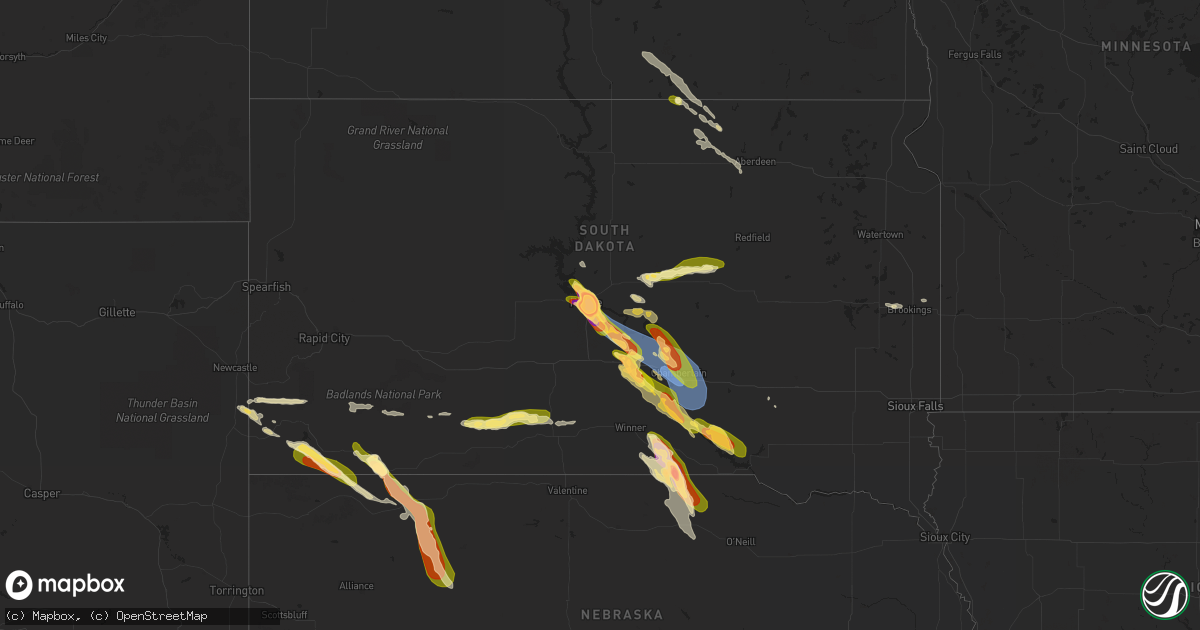
Hail Map in South Dakota on July 18, 2023
Get this storm
July 18 map
$229
one time, instant access
Download today. No call, no setup
Keep the $229
Bought the map and want the full workflow? Apply the entire $229 to a subscription within 7 days. None of it is wasted.
Every map, not just this one
This buys you this map. Subscription and you get every map we run, in the markets you choose from a few cities to whole states to nationwide. Plus real-time alerts the moment a storm fires.
Contact data
Name, contact info, occupancy, even credit band for addresses in the footprint. You go from where it hit to who to call.
Become the source they trust
Unlimited branding weather history reports on demand. You already have the documented answer ready for the property owner, and you are the one who showed up with it.
Property data and RoofTrace estimates
Pull up any address you have got, its value and the exact code rules for that jurisdiction, straight from One Click Code. Then RoofTrace estimates the squares, pitch, and roof value, priced the way you price.
Storm reports in South Dakota
South Dakota
| Date | Description |
|---|---|
| 07/18/20236:56 PM CDT | A local report indicates 2.50 inch wind near 1 ESE Pierre |
| 07/18/20236:47 PM CDT | Corrects previous hail report from pierre. Based on further analysis and communication. Photo submitted via social media without standard reference object... And no mea |
| 07/18/20236:47 PM CDT | Photo submitted via facebook. |
| 07/18/20236:45 PM CDT | Reported via facebook. |
| 07/18/20236:45 PM CDT | A local report indicates a tornado near 11 S Fort Pierre |
| 07/18/20236:45 PM CDT | Photo submitted via facebook. |
| 07/18/20236:43 PM CDT | Multiple public reports via facebook. |
| 07/18/20236:43 PM CDT | Photo submitted via twitter. |
| 07/18/20236:40 PM CDT | Very few hailstones... But the largest was the size of quarters. |
| 07/18/20236:40 PM CDT | A local report indicates 2.00 inch wind near Pierre Regional Airport |
| 07/18/20236:40 PM CDT | Reported via facebook. |
| 07/18/20236:37 PM CDT | A local report indicates 1.00 inch wind near Pierre |
| 07/18/20234:06 PM CDT | A local report indicates 1.75 inch wind near 5 N Pine Ridge |
| 07/18/20234:05 PM CDT | A local report indicates 1.00 inch wind near 2 W Pine Ridge |
| 07/18/20234:05 PM CDT | A local report indicates 1.00 inch wind near 1 W Pine Ridge |
| 07/18/202311:45 AM CDT | A local report indicates 1.00 inch wind near Pringle |
| 07/18/20233:19 AM CDT | Mostly pea and marble... Few quarters |
| 07/18/20232:58 AM CDT | Est 50 to 60 mph winds. Tree branches down... Furniture blown around. Small hail |
| 07/17/202311:45 PM CDT | A local report indicates 1.00 inch wind near Pringle |
| 07/17/202310:15 PM CDT | Sdsu mesonet site ggms2 7 ssw gregory. |
| 07/17/20238:49 PM CDT | A local report indicates 1.50 inch wind near 5 SW Kennebec |
| 07/17/20238:28 PM CDT | Mesonet station 54 reliance |
| 07/17/20238:22 PM CDT | Corrects previous tstm wnd gst report from 3 s chamberlain. |
| 07/17/20238:16 PM CDT | Tree damage... Downed powerlines... Tipped campers and roof damage reported in and near oacoma. |
| 07/17/20238:15 PM CDT | Mesonet station ocms2 oacoma 2w |
| 07/17/20238:05 PM CDT | Semi tipped over along i-90. |
| 07/17/20238:05 PM CDT | Semi tipped over along i-90. |
| 07/17/20237:48 PM CDT | A local report indicates 64 MPH wind near Lower Brule |
| 07/17/20237:45 PM CDT | Winds estimated at 70 mph... Trees damaged... Powerlines down... Solar panels damaged. Hail the size of nickels. |
| 07/17/20237:40 PM CDT | Hail was mostly pea size but a few were as large as quarters. Winds estimated at 40 mph. 1.20 inches of rain. The storm did not last long. |
| 07/17/20237:29 PM CDT | Personal weather station. |
| 07/17/20237:18 PM CDT | Photo submitted via facebook. |
| 07/17/20237:00 PM CDT | Photo submitted via twitter. |
All States Impacted by Hail Map on July 18, 2023
Cities Impacted by Hail Map on July 18, 2023
- Sulphur, IN
- Battletown, KY
- English, IN
- Leavenworth, IN
- Cape Girardeau, MO
- Jackson, MO
- Scott City, MO
- McClure, IL
- Chaffee, MO
- Thebes, IL
- Olive Branch, IL
- Ullin, IL
- Miller City, IL
- Tamms, IL
- Pulaski, IL
- Villa Ridge, IL
- Olmsted, IL
- Grand Chain, IL
- Mound City, IL
- Cairo, IL
- Mounds, IL
- Karnak, IL
- Kevil, KY
- La Center, KY
- Barlow, KY
- Metropolis, IL
- Paducah, KY
- West Paducah, KY
- Wickliffe, KY
- Cunningham, KY
- Bardwell, KY
- Jonesboro, IL
- Cypress, IL
- Dongola, IL
- Golconda, IL
- Belknap, IL
- Vienna, IL
- Melber, KY
- Grantsburg, IL
- Brookport, IL
- Salem, KY
- Smithland, KY
- Hampton, KY
- Burna, KY
- Symsonia, KY
- Tiline, KY
- Hickory, KY
- Boaz, KY
- Benton, KY
- Grand Rivers, KY
- Calvert City, KY
- Ledbetter, KY
- Marion, KY
- Princeton, KY
- Gilbertsville, KY
- Fredonia, KY
- Eddyville, KY
- Kuttawa, KY
- Cadiz, KY
- Ord, NE
- North Loup, NE
- Sweet Springs, MO
- Iberia, MO
- Sevierville, TN
- Odessa, MO
- Holden, MO
- Hilton, NY
- Tuscumbia, MO
- Eldon, MO
- Kaiser, MO
- Vienna, MO
- Warsaw, MO
- Waverly, MO
- Elyria, NE
- Burwell, NE
- Rapid City, SD
- Box Elder, SD
- Horse Cave, KY
- Cave City, KY
- Salem, MO
- Lenox, MO
- Hardyville, KY
- Centertown, MO
- Clinton, MO
- Calhoun, MO
- Onaga, KS
- Scotia, NE
- Elba, NE
- Saint Paul, NE
- Wolbach, NE
- Center, KY
- Versailles, MO
- Belle, MO
- Bland, MO
- Blairstown, MO
- Urich, MO
- Creighton, MO
- Dannebrog, NE
- Saint Libory, NE
- Excelsior Springs, MO
- Otterville, MO
- Bunceton, MO
- Leopold, IN
- Saint Croix, IN
- Vichy, MO
- Dixon, MO
- Rolla, MO
- Saint Elizabeth, MO
- Eugene, MO
- Cosby, TN
- Lincoln, MO
- Stover, MO
- Ionia, MO
- Sedalia, MO
- Mora, MO
- Green Ridge, MO
- Cole Camp, MO
- Spearfish, SD
- Belle Fourche, SD
- Archer, NE
- Palmer, NE
- Crocker, MO
- Richland, MO
- Brumley, MO
- Clarksburg, MO
- Tipton, MO
- Pilot Grove, MO
- Brinktown, MO
- Meta, MO
- Garden City, MO
- Archie, MO
- Hamlin, NY
- Waterport, NY
- Albion, NY
- Kendall, NY
- Kent, NY
- Edmonton, KY
- Knob Lick, KY
- Newburg, MO
- Ulman, MO
- Richmond, MO
- Warrensburg, MO
- Smithton, MO
- Gravois Mills, MO
- Windsor, MO
- Knob Noster, MO
- Saint Onge, SD
- Whitewood, SD
- Saint Robert, MO
- Centerview, MO
- Norborne, MO
- Edgar Springs, MO
- Charleston, MO
- Fancy Farm, KY
- Arlington, KY
- Mayfield, KY
- Murray, KY
- Farmington, KY
- Kirksey, KY
- Dexter, KY
- Almo, KY
- Hardin, KY
- New Concord, KY
- Hazel, KY
- Fort Campbell, KY
- Dover, TN
- Herndon, KY
- Woodlawn, TN
- Indian Mound, TN
- Big Rock, TN
- La Fayette, KY
- Bumpus Mills, TN
- Cumberland City, TN
- Clinton, KY
- Sedalia, KY
- Wingo, KY
- Buchanan, TN
- Puryear, TN
- Springville, TN
- Paris, TN
- Stewart, TN
- Tennessee Ridge, TN
- Big Sandy, TN
- Erin, TN
- Hopkinsville, KY
- Crofton, KY
- White Plains, KY
- Oak Grove, KY
- Cerulean, KY
- Dawson Springs, KY
- Gracey, KY
- Nortonville, KY
- Saint Charles, KY
- Cumberland Furnace, TN
- Cunningham, TN
- Pembroke, KY
- Palmyra, TN
- Vanleer, TN
- Clarksville, TN
- Ridgely, TN
- Lenox, TN
- Obion, TN
- Dyersburg, TN
- Finley, TN
- Halls, TN
- Newbern, TN
- Trenton, TN
- Dyer, TN
- Atwood, TN
- Bradford, TN
- Greenfield, TN
- Buena Vista, TN
- Bruceton, TN
- Huntingdon, TN
- Friendship, TN
- McKenzie, TN
- Trezevant, TN
- Milan, TN
- Trimble, TN
- Kenton, TN
- Rutherford, TN
- Rives, TN
- Sharon, TN
- Martin, TN
- Gleason, TN
- Hollow Rock, TN
- Mansfield, TN
- Hornbeak, TN
- Henry, TN
- Dresden, TN
- Union City, TN
- Troy, TN
- Medina, TN
- Lavinia, TN
- Cedar Grove, TN
- Yuma, TN
- Humboldt, TN
- Westport, TN
- Wildersville, TN
- Cottage Grove, TN
- Jackson, TN
- Gadsden, TN
- Camden, TN
- Sugar Tree, TN
- Holladay, TN
- Palmersville, TN
- Waverly, TN
- New Johnsonville, TN
- Eva, TN
- Trenton, KY
- Beech Creek, KY
- Greenville, KY
- Elkton, KY
- Lewisburg, KY
- Russellville, KY
- Adams, TN
- Olmstead, KY
- Adairville, KY
- Pleasant View, TN
- Springfield, TN
- Nashville, TN
- Joelton, TN
- Southside, TN
- Guthrie, KY
- Allensville, KY
- Sharon Grove, KY
- Ashland City, TN
- Belton, KY
- Charlotte, TN
- Cedar Hill, TN
- Chapmansboro, TN
- Kingston Springs, TN
- Burns, TN
- Pegram, TN
- Dickson, TN
- Hurricane Mills, TN
- McEwen, TN
- White Bluff, TN
- Alamo, TN
- Only, TN
- Oakfield, TN
- Bon Aqua, TN
- Fairview, TN
- Parsons, TN
- Lexington, TN
- Nunnelly, TN
- Lobelville, TN
- Dunmor, KY
- Greenbrier, TN
- Rochester, KY
- Morgantown, KY
- Beechmont, KY
- Auburn, KY
- Lyles, TN
- Centerville, TN
- Linden, TN
- Darden, TN
- Pine Ridge, SD
- Oregonia, OH
- Clarksville, OH
- New Vienna, OH
- Leesburg, OH
- Hillsboro, OH
- Blanchester, OH
- Midland, OH
- Greenfield, OH
- Duck River, TN
- Hohenwald, TN
- Scotts Hill, TN
- Huron, TN
- Beech Bluff, TN
- Decaturville, TN
- Mount Pleasant, TN
- Columbia, TN
- Hampshire, TN
- Williamsport, TN
- Primm Springs, TN
- Franklin, TN
- Santa Fe, TN
- Culleoka, TN
- Thompsons Station, TN
- Hermitage, TN
- Nolensville, TN
- Antioch, TN
- Brentwood, TN
- Spring Hill, TN
- Madison, TN
- Cottontown, TN
- Orlinda, TN
- Old Hickory, TN
- Hendersonville, TN
- Cross Plains, TN
- Goodlettsville, TN
- Portland, TN
- Franklin, KY
- Mount Juliet, TN
- White House, TN
- Whites Creek, TN
- Woodburn, KY
- Gallatin, TN
- Roundhill, KY
- Bowling Green, KY
- Rockfield, KY
- Scottsville, KY
- Alvaton, KY
- Brooksville, KY
- Lebanon, TN
- Westmoreland, TN
- Bethpage, TN
- Adolphus, KY
- Oakland, KY
- Castalian Springs, TN
- Hartsville, TN
- Watertown, TN
- Carthage, TN
- Elmwood, TN
- Pleasant Shade, TN
- Gordonsville, TN
- Riddleton, TN
- Lafayette, TN
- Dixon Springs, TN
- Murfreesboro, TN
- Arrington, TN
- Rockvale, TN
- Lascassas, TN
- Eagleville, TN
- Smyrna, TN
- College Grove, TN
- La Vergne, TN
- Christiana, TN
- Wartrace, TN
- Unionville, TN
- Belfast, TN
- Chapel Hill, TN
- Milton, TN
- Readyville, TN
- Shelbyville, TN
- Bell Buckle, TN
- Lewisburg, TN
- Beechgrove, TN
- Manchester, TN
- Normandy, TN
- Bradyville, TN
- Auburntown, TN
- Liberty, TN
- Brush Creek, TN
- Hickman, TN
- Alexandria, TN
- Woodbury, TN
- Morrison, TN
- Benton, MO
- Fulton, KY
- Dukedom, TN
- Summertown, TN
- Dowelltown, TN
- Gainesboro, TN
- Browder, KY
- Drakesboro, KY
- Rushville, NE
- Hollis, NH
- Nashua, NH
- Gordon, NE
- West Chester, OH
- Mason, OH
- Maineville, OH
- Crown City, OH
- Gallipolis, OH
- Apple Grove, WV
- Ashton, WV
- Fraziers Bottom, WV
- Buffalo, WV
- Pomeroy, OH
- West Columbia, WV
- Mason, WV
- Middleport, OH
- Racine, OH
- Hartford, WV
- New Haven, WV
- Syracuse, OH
- Letart, WV
- Big Springs, WV
- Brohard, WV
- Macfarlan, WV
- Smithville, WV
- Clifton, TN
- Waynesboro, TN
- Ethridge, TN
- Lawrenceburg, TN
- Westpoint, TN
- Leoma, TN
- Lynnville, TN
- Loretto, TN
- Petersburg, TN
- Taft, TN
- Ardmore, TN
- Minor Hill, TN
- Pulaski, TN
- Madison, AL
- Dellrose, TN
- Fayetteville, TN
- Frankewing, TN
- Cornersville, TN
- Toney, AL
- Tanner, AL
- Lester, AL
- Elkmont, AL
- Athens, AL
- Anderson, AL
- Goodspring, TN
- Ardmore, AL
- Huntsville, AL
- Five Points, TN
- Harvest, AL
- Prospect, TN
- Elora, TN
- Kelso, TN
- Hazel Green, AL
- Flintville, TN
- Lynchburg, TN
- Winchester, TN
- Belvidere, TN
- Mulberry, TN
- Tullahoma, TN
- Portland, OH
- Etowah, AR
- Manila, AR
- Osceola, AR
- Dyess, AR
- Lepanto, AR
- Caraway, AR
- Marked Tree, AR
- Tyronza, AR
- Joiner, AR
- Turrell, AR
- Gilmore, AR
- Keiser, AR
- Frenchmans Bayou, AR
- Henning, TN
- Bassett, AR
- Wilson, AR
- Bay, AR
- Black Oak, AR
- Trumann, AR
- Lake City, AR
- Jonesboro, AR
- Paragould, AR
- Brookland, AR
- Monette, AR
- Harrisburg, AR
- Weiner, AR
- Walnut Ridge, AR
- State University, AR
- Bono, AR
- Merriman, NE
- Milltown, IN
- Corydon, IN
- Depauw, IN
- Liberty, KY
- Dunlow, WV
- Tollesboro, KY
- Vanceburg, KY
- Leon, WV
- Lexington, KY
- Central, IN
- Mauckport, IN
- Webster, KY
- Rhodelia, KY
- Payneville, KY
- Union Star, KY
- Campbellsville, KY
- Greensburg, KY
- Summersville, KY
- Lynchburg, OH
- Etoile, KY
- Austin, KY
- Fountain Run, KY
- Glasgow, KY
- Hodgenville, KY
- Shelbyville, KY
- Simpsonville, KY
- Lebanon, KY
- Springfield, KY
- Loretto, KY
- Bardstown, KY
- New Haven, KY
- Summer Shade, KY
- Eighty Eight, KY
- Prospect, KY
- South Fulton, TN
- Raywick, KY
- Mount Sherman, KY
- Buffalo, KY
- Morrow, OH
- Ona, WV
- Lesage, WV
- Milton, WV
- Red House, WV
- Glenwood, WV
- Etowah, NC
- Horse Shoe, NC
- Mills River, NC
- Hendersonville, NC
- Webster, NY
- Martinsville, OH
- Lebanon, OH
- Dover, KY
- Augusta, KY
- Falmouth, KY
- Germantown, KY
- Foster, KY
- Langsville, OH
- Rutland, OH
- Piketon, OH
- Peebles, OH
- Goshen, OH
- Pleasant Plain, OH
- Wilmore, KY
- Lancaster, KY
- Harrodsburg, KY
- Argillite, KY
- Owingsville, KY
- Mount Sterling, KY
- Maysville, KY
- Lawrenceburg, KY
- Versailles, KY
- Salvisa, KY
- Glenville, WV
- Normantown, WV
- Poughkeepsie, AR
- Ravenden, AR
- Williford, AR
- Smithville, AR
- Latham, OH
- Wilmington, OH
- Middleburg, KY
- Hustonville, KY
- Birdseye, IN
- Branchville, IN
- Bristow, IN
- Ironton, OH
- Russell, KY
- Flatwoods, KY
- Ripley, OH
- Kiahsville, WV
- Bragg City, MO
- Hayti, MO
- Steele, MO
- Caruthersville, MO
- Fort Pierce, FL
- Ashland, KY
- South Point, OH
- Marion, NC
- Paris, KY
- Luxora, AR
- Ripley, TN
- Georgetown, IN
- Ramsey, IN
- New Salisbury, IN
- Crandall, IN
- Tiptonville, TN
- Rochester, NY
- Rockport, IN
- Waynesville, OH
- Louisville, KY
- Boston, KY
- Lebanon Junction, KY
- Arden, NC
- Waynesburg, KY
- Kings Mountain, KY
- Asheville, NC
- Leicester, NC
- Candler, NC
- South Lebanon, OH
- Greenup, KY
- Powhatan, AR
- Black Rock, AR
- Lewisport, KY
- Willisburg, KY
- Chaplin, KY
- Burlison, TN
- Drummonds, TN
- Brighton, TN
- Munford, TN
- Munday, WV
- Brockport, NY
- Winchester, KY
- Ontario, NY
- Rome, IN
- Cannelton, IN
- Hardinsburg, KY
- Manchester, OH
- West Union, OH
- Port Saint Lucie, FL
- Portageville, MO
- Bath Springs, TN
- Middletown, OH
- Hamilton, OH
- Aberdeen, OH
- Laconia, IN
- Wilsondale, WV
- Fayetteville, OH
- Loveland, OH
- Fairfield, OH
- Cincinnati, OH
- Lenoir, NC
- Elizabethtown, KY
- New Hope, KY
- Reagan, TN
- Big Bend, WV
- Bainbridge, OH
- Nicholasville, KY
- Brownsville, TN
- Falls Of Rough, KY
- Churchs Ferry, ND
- Elk Horn, KY
- Brodhead, KY
- Yosemite, KY
- Crab Orchard, KY
- Columbia, KY
- Salt Lick, KY
- Brandenburg, KY
- Lyndonville, NY
- Hickman, KY
- Saint Albans, WV
- Hurricane, WV
- Collettsville, NC
- Sellersburg, IN
- Charlestown, IN
- Knifley, KY
- Lodgepole, NE
- Chappell, NE
- Dallas, SD
- Winner, SD
- Colome, SD
- Gregory, SD
- Herrick, SD
- Burke, SD
- Naper, NE
- Mills, NE
- Stuart, NE
- Newport, NE
- Kennebec, SD
- Reliance, SD
- Hamill, SD
- Chamberlain, SD
- Ashley, ND
- Bingham, NE
- Ashby, NE
- Ellsworth, NE
- Pierre, SD
- Fort Pierre, SD
- Atkinson, NE
- Bassett, NE
- Presho, SD
- Lower Brule, SD
- Harrold, SD
- Fort Thompson, SD
- Long Lake, SD
- Spiritwood, ND
- Sanborn, ND
- Jamestown, ND
- Valley City, ND
- Litchville, ND
- Douglas, WY
- Shawnee, WY
- Edgemont, SD
- Fessenden, ND
- Blunt, SD
- Pepperell, MA
- Jamestown, OH
- Jeffersonville, OH
- Saulsbury, TN
- Ashton, NE
- Arcadia, NE
- Comstock, NE
- Sargent, NE
- Holabird, SD
- Mount Orab, OH
- Sardinia, OH
- Harvey, ND
- Highmore, SD
- Custer, SD
- Branson, CO
- Wilkesville, OH
- Albany, OH
- Pickens, SC
- Russellville, AL
- Harrisville, WV
- Creston, WV
- Elizabeth, WV
- Gurley, NE
- Sidney, NE
- Covington, TN
- Ovid, CO
- McArthur, OH
- Southside, WV
- Gallipolis Ferry, WV
- Fancy Gap, VA
- Harrison, NE
- Crawford, NE
- Hamilton, AL
- Brilliant, AL
- Miller, SD
- Saint Lawrence, SD
- Ree Heights, SD
- Sedgwick, CO
- Julesburg, CO
- Zirconia, NC
- Marietta, SC
- Kit Carson, CO
- New Site, MS
- Marietta, MS
- Georgetown, OH
- Atoka, TN
- Millington, TN
- Decatur, AL
- Trinity, AL
- Tishomingo, MS
- Iuka, MS
- Hartselle, AL
- Oacoma, SD
- Corinth, MS
- Nauvoo, AL
- New Albany, IN
- Jeffersonville, IN
- Clarksville, IN
- Tuscumbia, AL
- Spruce Pine, AL
- Hodges, AL
- Red Bay, AL
- Vina, AL
- Hamden, OH
- Baldwyn, MS
- Booneville, MS
- Gravel Switch, KY
- Carbon Hill, AL
- Liberty, WV
- Bagdad, KY
- Frankfort, KY
- Pleasureville, KY
- Carrington, ND
- Newcastle, WY
- Eads, TN
- Arlington, TN
- Dennis, MS
- Ripley, MS
- Rossville, TN
- Collierville, TN
- Oakland, TN
- Crestwood, KY
- Goshen, KY
- Washington Court House, OH
- Central City, NE
- Russellville, OH
- Hamersville, OH
- Oran, MO
- Bertrand, MO
- Sikeston, MO
- Tremont, MS
- Belmont, MS
- Fulton, MS
- Golden, MS
- Bells, TN
- Denmark, TN
- Townley, AL
- Eldridge, AL
- Ray, OH
- Tiplersville, MS
- Walnut, MS
- Sugar City, CO
- Florence, AL
- Batavia, OH
- Williamsburg, OH
- Bethel, OH
- Ranger, WV
- Appleton, MN
- Pinson, TN
- Medon, TN
- Middleton, TN
- Mason, TN
- Dalton, NE
- Grand Junction, TN
- Falkner, MS
- Rienzi, MS
- Columbus, KY
- Rarden, OH
- Greenwood Springs, MS
- Vinton, OH
- Winchester, OH
- Williston, TN
- Somerville, TN
- Moscow, TN
- Memphis, TN
- Marion, AR
- Germantown, TN
- Cordova, TN
- Olive Branch, MS
- Southaven, MS
- Byhalia, MS
- Red Banks, MS
- Holly Springs, MS
- La Grange, TN
- Lamar, MS
- Michigan City, MS
- Blue Mountain, MS
- Potts Camp, MS
- Hickory Flat, MS
- Ashland, MS
- Myrtle, MS
- Oelrichs, SD
- Chadron, NE
- Henderson, TN
- Finger, TN
- Bethel Springs, TN
- Hornsby, TN
- Enville, TN
- Toone, TN
- Selmer, TN
- Adamsville, TN
- Bolivar, TN
- Crump, TN
- Olivehill, TN
- Lutts, TN
- Ramer, TN
- Sardis, TN
- Savannah, TN
- Michie, TN
- Stantonville, TN
- Milledgeville, TN
- Shiloh, TN
- Guys, TN
- Counce, TN
- Waterloo, AL
- Collinwood, TN
- Morris Chapel, TN
- Vivian, SD
- Pukwana, SD
- Kimball, SD
- Cherokee, AL
- Burnsville, MS
- Cypress Inn, TN
- Guntown, MS
- New Albany, MS
- Tupelo, MS
- Saltillo, MS
- Dumas, MS
- Blue Springs, MS
- Mooreville, MS
- Mantachie, MS
- Platte, SD
- Geddes, SD
- Water Valley, KY
- Lake Andes, SD
- Fayette, MO
- Rocheport, MO
- Columbia, MO
- Coxs Mills, WV
- Wanblee, SD
- Martin, SD
- Long Valley, SD
- Bowdon, ND
- Cathay, ND
- Norris, SD
- White River, SD
- Troy, NH
- Marlborough, NH
- Belcourt, ND
- Mylo, ND
- Oshkosh, NE
- Souris, ND
- Venango, NE
- Wood, SD
- White, SD
- Rolla, ND
- Leola, SD
- Frohna, MO
- Uniontown, MO
- California, MO
- Prairie Home, MO
- Volga, SD
- Brookings, SD
- Arlington, SD
- Carbondale, IL
- Makanda, IL
- Canby, MN
- Sykeston, ND
- Enderlin, ND
- Wishek, ND
- Lynd, MN
- Russell, MN
- Fairburn, SD
- Hay Springs, NE
- Stickney, SD
- Fenton, MO
- Peetz, CO
- Padroni, CO
- Buchanan, ND
- Clara City, MN
- Wolf Lake, IL
- Murphysboro, IL
- De Soto, IL
- Dunseith, ND
- Bottineau, ND
- Union, MO
- Robertsville, MO
- Saint Clair, MO
- Oakman, AL
- Liberty, NC
- Carterville, IL
- Jasper, AL
- Kathryn, ND
- Ypsilanti, ND
- Salem, SC
- Saint John, ND
- Hot Springs, SD
- Oneill, NE
- Scott Depot, WV
- Hardin, MO
- Northport, AL
- Tuscaloosa, AL
- Marion, IL
- Ogallala, NE
- Anna, IL
- Cobden, IL
- Chamois, MO
- Mount Vernon, SD
- Alto Pass, IL
- Energy, IL
- Sedgewickville, MO
- Perryville, MO
- Stonefort, IL
- Ozark, IL
- Simpson, IL
- New Burnside, IL
- Creal Springs, IL
- Goreville, IL
- Kyle, SD
- Williamsburg, MO
- Montgomery City, MO
- New Florence, MO
- Hillsboro, MO
- Vergennes, IL
- Syracuse, MO
- Wimbledon, ND
- Parmelee, SD
- Winfield, AL
- Guin, AL
- Buncombe, IL
- Ellis Grove, IL
- Chester, IL
- Altenburg, MO
- Oak Ridge, MO
- Grand Tower, IL
- Parrish, AL
- Vernon, AL
- Kennedy, AL
- Fayette, AL
- Murdock, MN
- Dittmer, MO
- Starkweather, ND
- Bloomsdale, MO
- Sainte Genevieve, MO
- Villa Ridge, MO
- Nome, ND
- Egeland, ND
- Allen, SD
- Hyannis, NE
- Raymond, MN
- Aberdeen, SD
- Ipswich, SD
- Rosebud, MO
- Sullivan, MO
- Leslie, MO
- Gerald, MO
- Ghent, MN
- Minneota, MN
- Lynch, NE
- Spencer, NE
- Bristow, NE
- Perth, ND
- Modoc, IL
- Prairie Du Rocher, IL
- Springview, NE
- Marthasville, MO
- Hermann, MO
- Morrison, MO
- Boyd, MN
- Dawson, MN
- Haleyville, AL
- Festus, MO
- Grantsville, WV
- Fults, IL
- Aurora, NE
- Taunton, MN
- Madison, MN
- Clarkfield, MN
- Edmore, ND
- Lawton, ND
- Whitman, NE
- Owensville, MO
- Bonnots Mill, MO
- Tebbetts, MO
- New Bloomfield, MO
- Mount Sterling, MO
- Linn, MO
- Steedman, MO
- Mokane, MO
- Fulton, MO
- Whitney, NE
- Smithton, IL
- Waterloo, IL
- New Athens, IL
- Crook, CO
- Old Appleton, MO
- High Ridge, MO
- Ballwin, MO
- Eureka, MO
- Pinckneyville, IL
- Elkville, IL
- Eddyville, IL
- Ava, IL
- Mapleton, MN
- Berry, AL
- Echo, MN
- Wood Lake, MN
- Porter, MN
- Ashland, MO
- Verdigre, NE
- Winnetoon, NE
- Washington, MO
- Jamestown, MO
- Sumerco, WV
- Midkiff, WV
- Alkol, WV
- Griffithsville, WV
- Spurlockville, WV
- Branchland, WV
- Crum, WV
- Fort Gay, WV
- Yawkey, WV
- Harts, WV
- Milan, NH
- Andover, ME
- Errol, NH
- Morehead, KY
- Valley Park, MO
- Wildwood, MO
- Bisbee, ND
- Rocklake, ND
- Pacific, MO
- Augusta, MO
- Warrenton, MO


