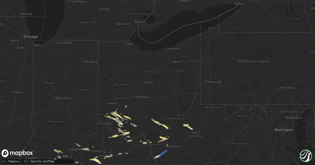
Hail Map in Ohio on July 18, 2023
Get this storm
July 18 map
$229
one time, instant access
Download today. No call, no setup
Keep the $229
Bought the map and want the full workflow? Apply the entire $229 to a subscription within 7 days. None of it is wasted.
Every map, not just this one
This buys you this map. Subscription and you get every map we run, in the markets you choose from a few cities to whole states to nationwide. Plus real-time alerts the moment a storm fires.
Contact data
Name, contact info, occupancy, even credit band for addresses in the footprint. You go from where it hit to who to call.
Become the source they trust
Unlimited branding weather history reports on demand. You already have the documented answer ready for the property owner, and you are the one who showed up with it.
Property data and RoofTrace estimates
Pull up any address you have got, its value and the exact code rules for that jurisdiction, straight from One Click Code. Then RoofTrace estimates the squares, pitch, and roof value, priced the way you price.
Storm reports in Ohio
Ohio
| Date | Description |
|---|---|
| 07/18/20235:54 PM CDT | Trees and power lines down throughout west union. Time estimated from radar. |
| 07/18/20235:36 PM CDT | Tree down near intersection of 324 and state route 160. |
| 07/18/20235:36 PM CDT | Tree down along lake road. Time estimated from radar. |
| 07/18/20235:35 PM CDT | Tree down along martindill road. |
| 07/18/20235:34 PM CDT | Trees and power lines down at old us 52 between grays lane and birney lane. Time estimated from radar. |
| 07/18/20235:21 PM CDT | Some tree limbs reported down in the buford area. Time estimated from radar. |
| 07/18/20235:16 PM CDT | Trees reported down near jasper on state route 104. Time estimated from radar. |
| 07/18/20235:13 PM CDT | Numerous trees down on us68 between mount orab and fayetteville. Most damage in chasetown. Time estimated from radar. |
| 07/18/20235:11 PM CDT | Trees down on power lines on spring grove road. Time estimated from radar. |
| 07/18/20235:10 PM CDT | Tree reported down on state route 243. Time estimated from radar. |
| 07/18/20235:07 PM CDT | Several trees and large limbs reported down in town. Time estimated fr |
| 07/18/20235:07 PM CDT | Several trees and large limbs reported down in town. Time estimated from radar. |
| 07/18/20235:07 PM CDT | A local report indicates 1.00 inch wind near Racine |
| 07/18/20235:05 PM CDT | Tree down near the intersection of oak street and south 4th street. Time estimated by radar. |
| 07/18/20235:02 PM CDT | Tree down on state route 93. Time estimated from radar. |
| 07/18/20235:00 PM CDT | Multiple pictures of trees down or snapped in and around town of syracuse sent on social media. Time radar estimated. |
| 07/18/20234:46 PM CDT | Lawrence county 911 reporting a tree has fallen and is blocking the road in the 700 block of county rd 6. In ironton. Power lines were also compromised. Time estimated |
| 07/18/20234:45 PM CDT | Lawrence county 911 reporting a tree has fallen in the 2000 block of murdock road at ora richey road. Time estimated by radar. |
| 07/18/20234:45 PM CDT | Trees down on back road. Time estimated from radar. |
| 07/18/20234:45 PM CDT | Corrects report source from previous tstm wnd dmg report from 3 s kincaid springs. Trees reported down on grassy fork road near houghland hill road. Time estimated from |
| 07/18/20234:45 PM CDT | Trees reported down on grassy fork road near houghland hill road. Time estimated from radar. |
| 07/18/20234:45 PM CDT | Tree fell on top of a vehicle and into the road at the intersection of north second street and railroad street. Time estimated from radar. |
| 07/18/20234:29 PM CDT | Several trees and power lines down in deerfield and hamilton townships. Time estimated from radar. |
| 07/18/20234:26 PM CDT | Trees reported down in nile township. Time estimated from radar. |
| 07/18/20234:25 PM CDT | A local report indicates 1.00 inch wind near 1 WSW Mason |
| 07/18/20234:20 PM CDT | Numerous trees down on us 52 in ripley area. Time estimated from radar. |
| 07/18/20234:18 PM CDT | Corrects time from previous tstm wnd dmg report from 10 ssw west portsmouth. Trees reported down on tipton lane. Time estimated from radar. |
| 07/18/20233:32 PM CDT | Several branches down on large tree. Photo submitted on social media. Time estimated from radar. |
| 07/18/20233:32 PM CDT | Photo posted on social media. Time estimated from radar. |
| 07/18/20233:32 PM CDT | Photo posted on social media. Time estimated from radar. |
| 07/18/20233:29 PM CDT | A local report indicates 1.50 inch wind near 2 WNW Clarksville |
| 07/18/20233:21 PM CDT | A local report indicates 1.00 inch wind near 2 WNW Clarksville |
| 07/17/20238:13 PM CDT | Trees reported down on tipton lane. Time estimated from radar. |
All States Impacted by Hail Map on July 18, 2023
Cities Impacted by Hail Map on July 18, 2023
- Sulphur, IN
- Battletown, KY
- English, IN
- Leavenworth, IN
- Cape Girardeau, MO
- Jackson, MO
- Scott City, MO
- McClure, IL
- Chaffee, MO
- Thebes, IL
- Olive Branch, IL
- Ullin, IL
- Miller City, IL
- Tamms, IL
- Pulaski, IL
- Villa Ridge, IL
- Olmsted, IL
- Grand Chain, IL
- Mound City, IL
- Cairo, IL
- Mounds, IL
- Karnak, IL
- Kevil, KY
- La Center, KY
- Barlow, KY
- Metropolis, IL
- Paducah, KY
- West Paducah, KY
- Wickliffe, KY
- Cunningham, KY
- Bardwell, KY
- Jonesboro, IL
- Cypress, IL
- Dongola, IL
- Golconda, IL
- Belknap, IL
- Vienna, IL
- Melber, KY
- Grantsburg, IL
- Brookport, IL
- Salem, KY
- Smithland, KY
- Hampton, KY
- Burna, KY
- Symsonia, KY
- Tiline, KY
- Hickory, KY
- Boaz, KY
- Benton, KY
- Grand Rivers, KY
- Calvert City, KY
- Ledbetter, KY
- Marion, KY
- Princeton, KY
- Gilbertsville, KY
- Fredonia, KY
- Eddyville, KY
- Kuttawa, KY
- Cadiz, KY
- Ord, NE
- North Loup, NE
- Sweet Springs, MO
- Iberia, MO
- Sevierville, TN
- Odessa, MO
- Holden, MO
- Hilton, NY
- Tuscumbia, MO
- Eldon, MO
- Kaiser, MO
- Vienna, MO
- Warsaw, MO
- Waverly, MO
- Elyria, NE
- Burwell, NE
- Rapid City, SD
- Box Elder, SD
- Horse Cave, KY
- Cave City, KY
- Salem, MO
- Lenox, MO
- Hardyville, KY
- Centertown, MO
- Clinton, MO
- Calhoun, MO
- Onaga, KS
- Scotia, NE
- Elba, NE
- Saint Paul, NE
- Wolbach, NE
- Center, KY
- Versailles, MO
- Belle, MO
- Bland, MO
- Blairstown, MO
- Urich, MO
- Creighton, MO
- Dannebrog, NE
- Saint Libory, NE
- Excelsior Springs, MO
- Otterville, MO
- Bunceton, MO
- Leopold, IN
- Saint Croix, IN
- Vichy, MO
- Dixon, MO
- Rolla, MO
- Saint Elizabeth, MO
- Eugene, MO
- Cosby, TN
- Lincoln, MO
- Stover, MO
- Ionia, MO
- Sedalia, MO
- Mora, MO
- Green Ridge, MO
- Cole Camp, MO
- Spearfish, SD
- Belle Fourche, SD
- Archer, NE
- Palmer, NE
- Crocker, MO
- Richland, MO
- Brumley, MO
- Clarksburg, MO
- Tipton, MO
- Pilot Grove, MO
- Brinktown, MO
- Meta, MO
- Garden City, MO
- Archie, MO
- Hamlin, NY
- Waterport, NY
- Albion, NY
- Kendall, NY
- Kent, NY
- Edmonton, KY
- Knob Lick, KY
- Newburg, MO
- Ulman, MO
- Richmond, MO
- Warrensburg, MO
- Smithton, MO
- Gravois Mills, MO
- Windsor, MO
- Knob Noster, MO
- Saint Onge, SD
- Whitewood, SD
- Saint Robert, MO
- Centerview, MO
- Norborne, MO
- Edgar Springs, MO
- Charleston, MO
- Fancy Farm, KY
- Arlington, KY
- Mayfield, KY
- Murray, KY
- Farmington, KY
- Kirksey, KY
- Dexter, KY
- Almo, KY
- Hardin, KY
- New Concord, KY
- Hazel, KY
- Fort Campbell, KY
- Dover, TN
- Herndon, KY
- Woodlawn, TN
- Indian Mound, TN
- Big Rock, TN
- La Fayette, KY
- Bumpus Mills, TN
- Cumberland City, TN
- Clinton, KY
- Sedalia, KY
- Wingo, KY
- Buchanan, TN
- Puryear, TN
- Springville, TN
- Paris, TN
- Stewart, TN
- Tennessee Ridge, TN
- Big Sandy, TN
- Erin, TN
- Hopkinsville, KY
- Crofton, KY
- White Plains, KY
- Oak Grove, KY
- Cerulean, KY
- Dawson Springs, KY
- Gracey, KY
- Nortonville, KY
- Saint Charles, KY
- Cumberland Furnace, TN
- Cunningham, TN
- Pembroke, KY
- Palmyra, TN
- Vanleer, TN
- Clarksville, TN
- Ridgely, TN
- Lenox, TN
- Obion, TN
- Dyersburg, TN
- Finley, TN
- Halls, TN
- Newbern, TN
- Trenton, TN
- Dyer, TN
- Atwood, TN
- Bradford, TN
- Greenfield, TN
- Buena Vista, TN
- Bruceton, TN
- Huntingdon, TN
- Friendship, TN
- McKenzie, TN
- Trezevant, TN
- Milan, TN
- Trimble, TN
- Kenton, TN
- Rutherford, TN
- Rives, TN
- Sharon, TN
- Martin, TN
- Gleason, TN
- Hollow Rock, TN
- Mansfield, TN
- Hornbeak, TN
- Henry, TN
- Dresden, TN
- Union City, TN
- Troy, TN
- Medina, TN
- Lavinia, TN
- Cedar Grove, TN
- Yuma, TN
- Humboldt, TN
- Westport, TN
- Wildersville, TN
- Cottage Grove, TN
- Jackson, TN
- Gadsden, TN
- Camden, TN
- Sugar Tree, TN
- Holladay, TN
- Palmersville, TN
- Waverly, TN
- New Johnsonville, TN
- Eva, TN
- Trenton, KY
- Beech Creek, KY
- Greenville, KY
- Elkton, KY
- Lewisburg, KY
- Russellville, KY
- Adams, TN
- Olmstead, KY
- Adairville, KY
- Pleasant View, TN
- Springfield, TN
- Nashville, TN
- Joelton, TN
- Southside, TN
- Guthrie, KY
- Allensville, KY
- Sharon Grove, KY
- Ashland City, TN
- Belton, KY
- Charlotte, TN
- Cedar Hill, TN
- Chapmansboro, TN
- Kingston Springs, TN
- Burns, TN
- Pegram, TN
- Dickson, TN
- Hurricane Mills, TN
- McEwen, TN
- White Bluff, TN
- Alamo, TN
- Only, TN
- Oakfield, TN
- Bon Aqua, TN
- Fairview, TN
- Parsons, TN
- Lexington, TN
- Nunnelly, TN
- Lobelville, TN
- Dunmor, KY
- Greenbrier, TN
- Rochester, KY
- Morgantown, KY
- Beechmont, KY
- Auburn, KY
- Lyles, TN
- Centerville, TN
- Linden, TN
- Darden, TN
- Pine Ridge, SD
- Oregonia, OH
- Clarksville, OH
- New Vienna, OH
- Leesburg, OH
- Hillsboro, OH
- Blanchester, OH
- Midland, OH
- Greenfield, OH
- Duck River, TN
- Hohenwald, TN
- Scotts Hill, TN
- Huron, TN
- Beech Bluff, TN
- Decaturville, TN
- Mount Pleasant, TN
- Columbia, TN
- Hampshire, TN
- Williamsport, TN
- Primm Springs, TN
- Franklin, TN
- Santa Fe, TN
- Culleoka, TN
- Thompsons Station, TN
- Hermitage, TN
- Nolensville, TN
- Antioch, TN
- Brentwood, TN
- Spring Hill, TN
- Madison, TN
- Cottontown, TN
- Orlinda, TN
- Old Hickory, TN
- Hendersonville, TN
- Cross Plains, TN
- Goodlettsville, TN
- Portland, TN
- Franklin, KY
- Mount Juliet, TN
- White House, TN
- Whites Creek, TN
- Woodburn, KY
- Gallatin, TN
- Roundhill, KY
- Bowling Green, KY
- Rockfield, KY
- Scottsville, KY
- Alvaton, KY
- Brooksville, KY
- Lebanon, TN
- Westmoreland, TN
- Bethpage, TN
- Adolphus, KY
- Oakland, KY
- Castalian Springs, TN
- Hartsville, TN
- Watertown, TN
- Carthage, TN
- Elmwood, TN
- Pleasant Shade, TN
- Gordonsville, TN
- Riddleton, TN
- Lafayette, TN
- Dixon Springs, TN
- Murfreesboro, TN
- Arrington, TN
- Rockvale, TN
- Lascassas, TN
- Eagleville, TN
- Smyrna, TN
- College Grove, TN
- La Vergne, TN
- Christiana, TN
- Wartrace, TN
- Unionville, TN
- Belfast, TN
- Chapel Hill, TN
- Milton, TN
- Readyville, TN
- Shelbyville, TN
- Bell Buckle, TN
- Lewisburg, TN
- Beechgrove, TN
- Manchester, TN
- Normandy, TN
- Bradyville, TN
- Auburntown, TN
- Liberty, TN
- Brush Creek, TN
- Hickman, TN
- Alexandria, TN
- Woodbury, TN
- Morrison, TN
- Benton, MO
- Fulton, KY
- Dukedom, TN
- Summertown, TN
- Dowelltown, TN
- Gainesboro, TN
- Browder, KY
- Drakesboro, KY
- Rushville, NE
- Hollis, NH
- Nashua, NH
- Gordon, NE
- West Chester, OH
- Mason, OH
- Maineville, OH
- Crown City, OH
- Gallipolis, OH
- Apple Grove, WV
- Ashton, WV
- Fraziers Bottom, WV
- Buffalo, WV
- Pomeroy, OH
- West Columbia, WV
- Mason, WV
- Middleport, OH
- Racine, OH
- Hartford, WV
- New Haven, WV
- Syracuse, OH
- Letart, WV
- Big Springs, WV
- Brohard, WV
- Macfarlan, WV
- Smithville, WV
- Clifton, TN
- Waynesboro, TN
- Ethridge, TN
- Lawrenceburg, TN
- Westpoint, TN
- Leoma, TN
- Lynnville, TN
- Loretto, TN
- Petersburg, TN
- Taft, TN
- Ardmore, TN
- Minor Hill, TN
- Pulaski, TN
- Madison, AL
- Dellrose, TN
- Fayetteville, TN
- Frankewing, TN
- Cornersville, TN
- Toney, AL
- Tanner, AL
- Lester, AL
- Elkmont, AL
- Athens, AL
- Anderson, AL
- Goodspring, TN
- Ardmore, AL
- Huntsville, AL
- Five Points, TN
- Harvest, AL
- Prospect, TN
- Elora, TN
- Kelso, TN
- Hazel Green, AL
- Flintville, TN
- Lynchburg, TN
- Winchester, TN
- Belvidere, TN
- Mulberry, TN
- Tullahoma, TN
- Portland, OH
- Etowah, AR
- Manila, AR
- Osceola, AR
- Dyess, AR
- Lepanto, AR
- Caraway, AR
- Marked Tree, AR
- Tyronza, AR
- Joiner, AR
- Turrell, AR
- Gilmore, AR
- Keiser, AR
- Frenchmans Bayou, AR
- Henning, TN
- Bassett, AR
- Wilson, AR
- Bay, AR
- Black Oak, AR
- Trumann, AR
- Lake City, AR
- Jonesboro, AR
- Paragould, AR
- Brookland, AR
- Monette, AR
- Harrisburg, AR
- Weiner, AR
- Walnut Ridge, AR
- State University, AR
- Bono, AR
- Merriman, NE
- Milltown, IN
- Corydon, IN
- Depauw, IN
- Liberty, KY
- Dunlow, WV
- Tollesboro, KY
- Vanceburg, KY
- Leon, WV
- Lexington, KY
- Central, IN
- Mauckport, IN
- Webster, KY
- Rhodelia, KY
- Payneville, KY
- Union Star, KY
- Campbellsville, KY
- Greensburg, KY
- Summersville, KY
- Lynchburg, OH
- Etoile, KY
- Austin, KY
- Fountain Run, KY
- Glasgow, KY
- Hodgenville, KY
- Shelbyville, KY
- Simpsonville, KY
- Lebanon, KY
- Springfield, KY
- Loretto, KY
- Bardstown, KY
- New Haven, KY
- Summer Shade, KY
- Eighty Eight, KY
- Prospect, KY
- South Fulton, TN
- Raywick, KY
- Mount Sherman, KY
- Buffalo, KY
- Morrow, OH
- Ona, WV
- Lesage, WV
- Milton, WV
- Red House, WV
- Glenwood, WV
- Etowah, NC
- Horse Shoe, NC
- Mills River, NC
- Hendersonville, NC
- Webster, NY
- Martinsville, OH
- Lebanon, OH
- Dover, KY
- Augusta, KY
- Falmouth, KY
- Germantown, KY
- Foster, KY
- Langsville, OH
- Rutland, OH
- Piketon, OH
- Peebles, OH
- Goshen, OH
- Pleasant Plain, OH
- Wilmore, KY
- Lancaster, KY
- Harrodsburg, KY
- Argillite, KY
- Owingsville, KY
- Mount Sterling, KY
- Maysville, KY
- Lawrenceburg, KY
- Versailles, KY
- Salvisa, KY
- Glenville, WV
- Normantown, WV
- Poughkeepsie, AR
- Ravenden, AR
- Williford, AR
- Smithville, AR
- Latham, OH
- Wilmington, OH
- Middleburg, KY
- Hustonville, KY
- Birdseye, IN
- Branchville, IN
- Bristow, IN
- Ironton, OH
- Russell, KY
- Flatwoods, KY
- Ripley, OH
- Kiahsville, WV
- Bragg City, MO
- Hayti, MO
- Steele, MO
- Caruthersville, MO
- Fort Pierce, FL
- Ashland, KY
- South Point, OH
- Marion, NC
- Paris, KY
- Luxora, AR
- Ripley, TN
- Georgetown, IN
- Ramsey, IN
- New Salisbury, IN
- Crandall, IN
- Tiptonville, TN
- Rochester, NY
- Rockport, IN
- Waynesville, OH
- Louisville, KY
- Boston, KY
- Lebanon Junction, KY
- Arden, NC
- Waynesburg, KY
- Kings Mountain, KY
- Asheville, NC
- Leicester, NC
- Candler, NC
- South Lebanon, OH
- Greenup, KY
- Powhatan, AR
- Black Rock, AR
- Lewisport, KY
- Willisburg, KY
- Chaplin, KY
- Burlison, TN
- Drummonds, TN
- Brighton, TN
- Munford, TN
- Munday, WV
- Brockport, NY
- Winchester, KY
- Ontario, NY
- Rome, IN
- Cannelton, IN
- Hardinsburg, KY
- Manchester, OH
- West Union, OH
- Port Saint Lucie, FL
- Portageville, MO
- Bath Springs, TN
- Middletown, OH
- Hamilton, OH
- Aberdeen, OH
- Laconia, IN
- Wilsondale, WV
- Fayetteville, OH
- Loveland, OH
- Fairfield, OH
- Cincinnati, OH
- Lenoir, NC
- Elizabethtown, KY
- New Hope, KY
- Reagan, TN
- Big Bend, WV
- Bainbridge, OH
- Nicholasville, KY
- Brownsville, TN
- Falls Of Rough, KY
- Churchs Ferry, ND
- Elk Horn, KY
- Brodhead, KY
- Yosemite, KY
- Crab Orchard, KY
- Columbia, KY
- Salt Lick, KY
- Brandenburg, KY
- Lyndonville, NY
- Hickman, KY
- Saint Albans, WV
- Hurricane, WV
- Collettsville, NC
- Sellersburg, IN
- Charlestown, IN
- Knifley, KY
- Lodgepole, NE
- Chappell, NE
- Dallas, SD
- Winner, SD
- Colome, SD
- Gregory, SD
- Herrick, SD
- Burke, SD
- Naper, NE
- Mills, NE
- Stuart, NE
- Newport, NE
- Kennebec, SD
- Reliance, SD
- Hamill, SD
- Chamberlain, SD
- Ashley, ND
- Bingham, NE
- Ashby, NE
- Ellsworth, NE
- Pierre, SD
- Fort Pierre, SD
- Atkinson, NE
- Bassett, NE
- Presho, SD
- Lower Brule, SD
- Harrold, SD
- Fort Thompson, SD
- Long Lake, SD
- Spiritwood, ND
- Sanborn, ND
- Jamestown, ND
- Valley City, ND
- Litchville, ND
- Douglas, WY
- Shawnee, WY
- Edgemont, SD
- Fessenden, ND
- Blunt, SD
- Pepperell, MA
- Jamestown, OH
- Jeffersonville, OH
- Saulsbury, TN
- Ashton, NE
- Arcadia, NE
- Comstock, NE
- Sargent, NE
- Holabird, SD
- Mount Orab, OH
- Sardinia, OH
- Harvey, ND
- Highmore, SD
- Custer, SD
- Branson, CO
- Wilkesville, OH
- Albany, OH
- Pickens, SC
- Russellville, AL
- Harrisville, WV
- Creston, WV
- Elizabeth, WV
- Gurley, NE
- Sidney, NE
- Covington, TN
- Ovid, CO
- McArthur, OH
- Southside, WV
- Gallipolis Ferry, WV
- Fancy Gap, VA
- Harrison, NE
- Crawford, NE
- Hamilton, AL
- Brilliant, AL
- Miller, SD
- Saint Lawrence, SD
- Ree Heights, SD
- Sedgwick, CO
- Julesburg, CO
- Zirconia, NC
- Marietta, SC
- Kit Carson, CO
- New Site, MS
- Marietta, MS
- Georgetown, OH
- Atoka, TN
- Millington, TN
- Decatur, AL
- Trinity, AL
- Tishomingo, MS
- Iuka, MS
- Hartselle, AL
- Oacoma, SD
- Corinth, MS
- Nauvoo, AL
- New Albany, IN
- Jeffersonville, IN
- Clarksville, IN
- Tuscumbia, AL
- Spruce Pine, AL
- Hodges, AL
- Red Bay, AL
- Vina, AL
- Hamden, OH
- Baldwyn, MS
- Booneville, MS
- Gravel Switch, KY
- Carbon Hill, AL
- Liberty, WV
- Bagdad, KY
- Frankfort, KY
- Pleasureville, KY
- Carrington, ND
- Newcastle, WY
- Eads, TN
- Arlington, TN
- Dennis, MS
- Ripley, MS
- Rossville, TN
- Collierville, TN
- Oakland, TN
- Crestwood, KY
- Goshen, KY
- Washington Court House, OH
- Central City, NE
- Russellville, OH
- Hamersville, OH
- Oran, MO
- Bertrand, MO
- Sikeston, MO
- Tremont, MS
- Belmont, MS
- Fulton, MS
- Golden, MS
- Bells, TN
- Denmark, TN
- Townley, AL
- Eldridge, AL
- Ray, OH
- Tiplersville, MS
- Walnut, MS
- Sugar City, CO
- Florence, AL
- Batavia, OH
- Williamsburg, OH
- Bethel, OH
- Ranger, WV
- Appleton, MN
- Pinson, TN
- Medon, TN
- Middleton, TN
- Mason, TN
- Dalton, NE
- Grand Junction, TN
- Falkner, MS
- Rienzi, MS
- Columbus, KY
- Rarden, OH
- Greenwood Springs, MS
- Vinton, OH
- Winchester, OH
- Williston, TN
- Somerville, TN
- Moscow, TN
- Memphis, TN
- Marion, AR
- Germantown, TN
- Cordova, TN
- Olive Branch, MS
- Southaven, MS
- Byhalia, MS
- Red Banks, MS
- Holly Springs, MS
- La Grange, TN
- Lamar, MS
- Michigan City, MS
- Blue Mountain, MS
- Potts Camp, MS
- Hickory Flat, MS
- Ashland, MS
- Myrtle, MS
- Oelrichs, SD
- Chadron, NE
- Henderson, TN
- Finger, TN
- Bethel Springs, TN
- Hornsby, TN
- Enville, TN
- Toone, TN
- Selmer, TN
- Adamsville, TN
- Bolivar, TN
- Crump, TN
- Olivehill, TN
- Lutts, TN
- Ramer, TN
- Sardis, TN
- Savannah, TN
- Michie, TN
- Stantonville, TN
- Milledgeville, TN
- Shiloh, TN
- Guys, TN
- Counce, TN
- Waterloo, AL
- Collinwood, TN
- Morris Chapel, TN
- Vivian, SD
- Pukwana, SD
- Kimball, SD
- Cherokee, AL
- Burnsville, MS
- Cypress Inn, TN
- Guntown, MS
- New Albany, MS
- Tupelo, MS
- Saltillo, MS
- Dumas, MS
- Blue Springs, MS
- Mooreville, MS
- Mantachie, MS
- Platte, SD
- Geddes, SD
- Water Valley, KY
- Lake Andes, SD
- Fayette, MO
- Rocheport, MO
- Columbia, MO
- Coxs Mills, WV
- Wanblee, SD
- Martin, SD
- Long Valley, SD
- Bowdon, ND
- Cathay, ND
- Norris, SD
- White River, SD
- Troy, NH
- Marlborough, NH
- Belcourt, ND
- Mylo, ND
- Oshkosh, NE
- Souris, ND
- Venango, NE
- Wood, SD
- White, SD
- Rolla, ND
- Leola, SD
- Frohna, MO
- Uniontown, MO
- California, MO
- Prairie Home, MO
- Volga, SD
- Brookings, SD
- Arlington, SD
- Carbondale, IL
- Makanda, IL
- Canby, MN
- Sykeston, ND
- Enderlin, ND
- Wishek, ND
- Lynd, MN
- Russell, MN
- Fairburn, SD
- Hay Springs, NE
- Stickney, SD
- Fenton, MO
- Peetz, CO
- Padroni, CO
- Buchanan, ND
- Clara City, MN
- Wolf Lake, IL
- Murphysboro, IL
- De Soto, IL
- Dunseith, ND
- Bottineau, ND
- Union, MO
- Robertsville, MO
- Saint Clair, MO
- Oakman, AL
- Liberty, NC
- Carterville, IL
- Jasper, AL
- Kathryn, ND
- Ypsilanti, ND
- Salem, SC
- Saint John, ND
- Hot Springs, SD
- Oneill, NE
- Scott Depot, WV
- Hardin, MO
- Northport, AL
- Tuscaloosa, AL
- Marion, IL
- Ogallala, NE
- Anna, IL
- Cobden, IL
- Chamois, MO
- Mount Vernon, SD
- Alto Pass, IL
- Energy, IL
- Sedgewickville, MO
- Perryville, MO
- Stonefort, IL
- Ozark, IL
- Simpson, IL
- New Burnside, IL
- Creal Springs, IL
- Goreville, IL
- Kyle, SD
- Williamsburg, MO
- Montgomery City, MO
- New Florence, MO
- Hillsboro, MO
- Vergennes, IL
- Syracuse, MO
- Wimbledon, ND
- Parmelee, SD
- Winfield, AL
- Guin, AL
- Buncombe, IL
- Ellis Grove, IL
- Chester, IL
- Altenburg, MO
- Oak Ridge, MO
- Grand Tower, IL
- Parrish, AL
- Vernon, AL
- Kennedy, AL
- Fayette, AL
- Murdock, MN
- Dittmer, MO
- Starkweather, ND
- Bloomsdale, MO
- Sainte Genevieve, MO
- Villa Ridge, MO
- Nome, ND
- Egeland, ND
- Allen, SD
- Hyannis, NE
- Raymond, MN
- Aberdeen, SD
- Ipswich, SD
- Rosebud, MO
- Sullivan, MO
- Leslie, MO
- Gerald, MO
- Ghent, MN
- Minneota, MN
- Lynch, NE
- Spencer, NE
- Bristow, NE
- Perth, ND
- Modoc, IL
- Prairie Du Rocher, IL
- Springview, NE
- Marthasville, MO
- Hermann, MO
- Morrison, MO
- Boyd, MN
- Dawson, MN
- Haleyville, AL
- Festus, MO
- Grantsville, WV
- Fults, IL
- Aurora, NE
- Taunton, MN
- Madison, MN
- Clarkfield, MN
- Edmore, ND
- Lawton, ND
- Whitman, NE
- Owensville, MO
- Bonnots Mill, MO
- Tebbetts, MO
- New Bloomfield, MO
- Mount Sterling, MO
- Linn, MO
- Steedman, MO
- Mokane, MO
- Fulton, MO
- Whitney, NE
- Smithton, IL
- Waterloo, IL
- New Athens, IL
- Crook, CO
- Old Appleton, MO
- High Ridge, MO
- Ballwin, MO
- Eureka, MO
- Pinckneyville, IL
- Elkville, IL
- Eddyville, IL
- Ava, IL
- Mapleton, MN
- Berry, AL
- Echo, MN
- Wood Lake, MN
- Porter, MN
- Ashland, MO
- Verdigre, NE
- Winnetoon, NE
- Washington, MO
- Jamestown, MO
- Sumerco, WV
- Midkiff, WV
- Alkol, WV
- Griffithsville, WV
- Spurlockville, WV
- Branchland, WV
- Crum, WV
- Fort Gay, WV
- Yawkey, WV
- Harts, WV
- Milan, NH
- Andover, ME
- Errol, NH
- Morehead, KY
- Valley Park, MO
- Wildwood, MO
- Bisbee, ND
- Rocklake, ND
- Pacific, MO
- Augusta, MO
- Warrenton, MO


