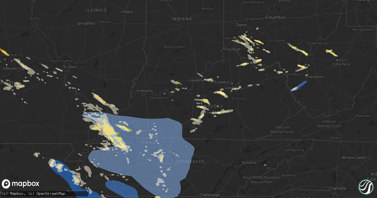
Hail Map in Kentucky on July 18, 2023
Get this storm
July 18 map
$229
one time, instant access
Download today. No call, no setup
Keep the $229
Bought the map and want the full workflow? Apply the entire $229 to a subscription within 7 days. None of it is wasted.
Every map, not just this one
This buys you this map. Subscription and you get every map we run, in the markets you choose from a few cities to whole states to nationwide. Plus real-time alerts the moment a storm fires.
Contact data
Name, contact info, occupancy, even credit band for addresses in the footprint. You go from where it hit to who to call.
Become the source they trust
Unlimited branding weather history reports on demand. You already have the documented answer ready for the property owner, and you are the one who showed up with it.
Property data and RoofTrace estimates
Pull up any address you have got, its value and the exact code rules for that jurisdiction, straight from One Click Code. Then RoofTrace estimates the squares, pitch, and roof value, priced the way you price.
Storm reports in Kentucky
Kentucky
| Date | Description |
|---|---|
| 07/18/20235:52 PM CDT | Marion county emergency manager sent pictures of a barn that was destroyed. Time estimated from radar. |
| 07/18/20235:43 PM CDT | Tree down in the pleasure ridge park area. |
| 07/18/20235:39 PM CDT | Multiple reports of trees down in campbellsville and across the county on roads and powerlines. A few structures were also damaged by falling trees. |
| 07/18/20235:24 PM CDT | Tree across the roadway. |
| 07/18/20235:21 PM CDT | Trees down near summerville. |
| 07/18/20235:05 PM CDT | Trees down near russell soccer complex. |
| 07/18/20235:00 PM CDT | Trees down near intersection of smith branch road and us highway 23 south. |
| 07/18/20235:00 PM CDT | Multiple trees with power lines down. Time estimated from radar. |
| 07/18/20234:54 PM CDT | Multiple trees down on roads in lebanon. Some are impassible. |
| 07/18/20234:52 PM CDT | Trees down. Time estimated from radar. |
| 07/18/20234:50 PM CDT | Tree contact caused power outages. |
| 07/18/20234:50 PM CDT | Trees down. Time estimated from radar. |
| 07/18/20234:41 PM CDT | Tree down along beechy creek. Time estimated on radar. |
| 07/18/20234:13 PM CDT | Tree down along se licking river rd and higgins branch rd. |
| 07/18/20234:08 PM CDT | Mesonet station jcak2 jackson raws. |
| 07/18/20234:03 PM CDT | Nws employees estimated wind gusts to between 60-70 mph at times... Which lasted about 5 minutes from 5:03 pm until about 5:08 pm. |
| 07/18/20234:00 PM CDT | Trees down on highway 1812 on frozen hill. Time estimated from radar. |
| 07/18/20233:52 PM CDT | Corrects previous tstm wnd dmg report from 1 sw murphyfork. Off-duty nws employee relayed a report of a down tree about a mile up murphy fork road. Time estimated from |
| 07/18/20233:50 PM CDT | Trees down near the intersection of bowling green road and little muddy church road. Time estimated by radar. |
| 07/18/20233:38 PM CDT | Social media report of two picnics flipped over and moved about 30 feet at intersection of terrill fork rd and holly road. Time estimated by velocity signature on radar |
| 07/18/20233:36 PM CDT | Large tree branch down on rose bend rd. Time estimated by radar velocity signature. Report and video from social media. |
| 07/18/20233:36 PM CDT | Report of huge tree blocking tom rose branch rd. Report via social media. |
| 07/18/20233:25 PM CDT | Reports of multiple trees down on roads and houses within russellville. Time estimated by radar. |
| 07/18/20233:25 PM CDT | Dispatch reported multiple trees down along both highways 587 and 11 south of beattyville. |
| 07/18/20233:23 PM CDT | Two vehicles trapped by trees on either side and power line down on lower licking road in rowan county. No injuries. Time estimated by radar. |
| 07/18/20233:10 PM CDT | Tree down around the 4000 block of hwy 1209. Time estimate by radar. |
| 07/18/20233:05 PM CDT | Trees down across bath county. Time estimated from radar. |
| 07/18/20233:05 PM CDT | Social media report and photo of snapped tree limb on telephone line. Time estimated based on velocity radar signature. |
| 07/18/20233:02 PM CDT | Tree down at entrance of mountain crest apartments entrance. |
| 07/18/20233:01 PM CDT | Tree down in backyard of residence. Report via social media. |
| 07/18/20232:57 PM CDT | Social media report of power lines down along richmond road or highway 52 near the madison and estill county line. |
| 07/18/20232:55 PM CDT | Numerous trees down along highway u.s. 60 from 4670 us 60 to the bath county line. That portion of the highway will be close a few hours for tree removal. Also... House |
| 07/18/20232:52 PM CDT | Multiple trees down along hwy 2004 around the 400 and 600 blocks. Time estimated by radar. |
| 07/18/20232:45 PM CDT | Trees down along white turley pike and wades mill roads. Time estimated by radar. |
| 07/18/20232:26 PM CDT | A local report indicates 70 MPH wind near 3 NNW Hopkinsville |
| 07/18/20232:07 PM CDT | Storm damage to trailer and barn. |
| 07/18/20232:07 PM CDT | Trees down. |
| 07/18/20232:05 PM CDT | Mobile home and barn destroyed along cadiz road just east of i-24. Late report. |
| 07/18/20232:00 PM CDT | Delayed report. Tree down in bryantsville. |
| 07/18/20231:52 PM CDT | Off-duty nws employee relayed a report of a down tree about a mile up murphy fork road. Time estimated from radar. |
| 07/18/20231:50 PM CDT | Tree fell on vehicle. |
| 07/18/20231:43 PM CDT | Measured wind gust on the top of kentucky dam. |
| 07/18/20231:37 PM CDT | Hail ranged from peas to the size of a quarter. |
| 07/18/20231:35 PM CDT | Awos station km25 mayfield ky. |
| 07/18/20231:30 PM CDT | Trees and power lines down in town. |
| 07/18/20231:25 PM CDT | Multiple trees and powerlines down. |
| 07/18/20231:19 PM CDT | Intersection of old mayfield and bryan rd. 60+ mph winds reported. |
| 07/18/20231:00 PM CDT | Trees down over the road. |
| 07/18/202312:49 PM CDT | Multiple trees down windows blown out in house. |
| 07/18/202312:48 PM CDT | Trees down in bandana. Trees also down throughout the county. |
| 07/18/202311:56 AM CDT | Multiple trees down or uprooted... Some laying against homes. |
| 07/18/20236:23 AM CDT | Tree down on highway 68... Blocking one lane of traffic. |
| 07/18/20235:52 AM CDT | A local report indicates 1.25 inch wind near 6 NNE Faridealing |
| 07/18/20235:30 AM CDT | A local report indicates 1.25 inch wind near 5 N Faridealing |
| 07/18/20234:55 AM CDT | Tree down on lawrence road in southwest calloway county. Road is also flooded. |
| 07/18/20233:30 AM CDT | Tree down blocking highway 45. Time estimated via radar. |
| 07/18/20233:26 AM CDT | Spotter reports widespread wind damage in sedalia... Estimates 70-80 mph gusts. |
| 07/18/20231:44 AM CDT | 8 inch in diameter tree blocking highway 94 about 1.5 miles southwest of cuba... Ky. |
| 07/17/20238:13 PM CDT | Laurel county dispatch relayed a report of a down tree on the powerlines near the 160 block of southland dr. |
| 07/17/20237:50 PM CDT | Tyner fire dept reported to 911 dispatch a tree was down blocking the road in the daniel boone national forest. Tree was removed by the fire department. Time estimated |
| 07/17/20237:45 PM CDT | Laurel county dispatch relayed a report of a down tree with powerlines near the 850 block of ky-3434. |
| 07/17/20237:30 PM CDT | Tree and powerlines down at ky highway 3434 near noelle road. Time estimated from radar velocity signature. |
| 07/17/20237:00 PM CDT | Tree down on fence on gum sulphur rd in the brodhead area. Time estimated by radar velocity signature. |
All States Impacted by Hail Map on July 18, 2023
Cities Impacted by Hail Map on July 18, 2023
- Sulphur, IN
- Battletown, KY
- English, IN
- Leavenworth, IN
- Cape Girardeau, MO
- Jackson, MO
- Scott City, MO
- McClure, IL
- Chaffee, MO
- Thebes, IL
- Olive Branch, IL
- Ullin, IL
- Miller City, IL
- Tamms, IL
- Pulaski, IL
- Villa Ridge, IL
- Olmsted, IL
- Grand Chain, IL
- Mound City, IL
- Cairo, IL
- Mounds, IL
- Karnak, IL
- Kevil, KY
- La Center, KY
- Barlow, KY
- Metropolis, IL
- Paducah, KY
- West Paducah, KY
- Wickliffe, KY
- Cunningham, KY
- Bardwell, KY
- Jonesboro, IL
- Cypress, IL
- Dongola, IL
- Golconda, IL
- Belknap, IL
- Vienna, IL
- Melber, KY
- Grantsburg, IL
- Brookport, IL
- Salem, KY
- Smithland, KY
- Hampton, KY
- Burna, KY
- Symsonia, KY
- Tiline, KY
- Hickory, KY
- Boaz, KY
- Benton, KY
- Grand Rivers, KY
- Calvert City, KY
- Ledbetter, KY
- Marion, KY
- Princeton, KY
- Gilbertsville, KY
- Fredonia, KY
- Eddyville, KY
- Kuttawa, KY
- Cadiz, KY
- Ord, NE
- North Loup, NE
- Sweet Springs, MO
- Iberia, MO
- Sevierville, TN
- Odessa, MO
- Holden, MO
- Hilton, NY
- Tuscumbia, MO
- Eldon, MO
- Kaiser, MO
- Vienna, MO
- Warsaw, MO
- Waverly, MO
- Elyria, NE
- Burwell, NE
- Rapid City, SD
- Box Elder, SD
- Horse Cave, KY
- Cave City, KY
- Salem, MO
- Lenox, MO
- Hardyville, KY
- Centertown, MO
- Clinton, MO
- Calhoun, MO
- Onaga, KS
- Scotia, NE
- Elba, NE
- Saint Paul, NE
- Wolbach, NE
- Center, KY
- Versailles, MO
- Belle, MO
- Bland, MO
- Blairstown, MO
- Urich, MO
- Creighton, MO
- Dannebrog, NE
- Saint Libory, NE
- Excelsior Springs, MO
- Otterville, MO
- Bunceton, MO
- Leopold, IN
- Saint Croix, IN
- Vichy, MO
- Dixon, MO
- Rolla, MO
- Saint Elizabeth, MO
- Eugene, MO
- Cosby, TN
- Lincoln, MO
- Stover, MO
- Ionia, MO
- Sedalia, MO
- Mora, MO
- Green Ridge, MO
- Cole Camp, MO
- Spearfish, SD
- Belle Fourche, SD
- Archer, NE
- Palmer, NE
- Crocker, MO
- Richland, MO
- Brumley, MO
- Clarksburg, MO
- Tipton, MO
- Pilot Grove, MO
- Brinktown, MO
- Meta, MO
- Garden City, MO
- Archie, MO
- Hamlin, NY
- Waterport, NY
- Albion, NY
- Kendall, NY
- Kent, NY
- Edmonton, KY
- Knob Lick, KY
- Newburg, MO
- Ulman, MO
- Richmond, MO
- Warrensburg, MO
- Smithton, MO
- Gravois Mills, MO
- Windsor, MO
- Knob Noster, MO
- Saint Onge, SD
- Whitewood, SD
- Saint Robert, MO
- Centerview, MO
- Norborne, MO
- Edgar Springs, MO
- Charleston, MO
- Fancy Farm, KY
- Arlington, KY
- Mayfield, KY
- Murray, KY
- Farmington, KY
- Kirksey, KY
- Dexter, KY
- Almo, KY
- Hardin, KY
- New Concord, KY
- Hazel, KY
- Fort Campbell, KY
- Dover, TN
- Herndon, KY
- Woodlawn, TN
- Indian Mound, TN
- Big Rock, TN
- La Fayette, KY
- Bumpus Mills, TN
- Cumberland City, TN
- Clinton, KY
- Sedalia, KY
- Wingo, KY
- Buchanan, TN
- Puryear, TN
- Springville, TN
- Paris, TN
- Stewart, TN
- Tennessee Ridge, TN
- Big Sandy, TN
- Erin, TN
- Hopkinsville, KY
- Crofton, KY
- White Plains, KY
- Oak Grove, KY
- Cerulean, KY
- Dawson Springs, KY
- Gracey, KY
- Nortonville, KY
- Saint Charles, KY
- Cumberland Furnace, TN
- Cunningham, TN
- Pembroke, KY
- Palmyra, TN
- Vanleer, TN
- Clarksville, TN
- Ridgely, TN
- Lenox, TN
- Obion, TN
- Dyersburg, TN
- Finley, TN
- Halls, TN
- Newbern, TN
- Trenton, TN
- Dyer, TN
- Atwood, TN
- Bradford, TN
- Greenfield, TN
- Buena Vista, TN
- Bruceton, TN
- Huntingdon, TN
- Friendship, TN
- McKenzie, TN
- Trezevant, TN
- Milan, TN
- Trimble, TN
- Kenton, TN
- Rutherford, TN
- Rives, TN
- Sharon, TN
- Martin, TN
- Gleason, TN
- Hollow Rock, TN
- Mansfield, TN
- Hornbeak, TN
- Henry, TN
- Dresden, TN
- Union City, TN
- Troy, TN
- Medina, TN
- Lavinia, TN
- Cedar Grove, TN
- Yuma, TN
- Humboldt, TN
- Westport, TN
- Wildersville, TN
- Cottage Grove, TN
- Jackson, TN
- Gadsden, TN
- Camden, TN
- Sugar Tree, TN
- Holladay, TN
- Palmersville, TN
- Waverly, TN
- New Johnsonville, TN
- Eva, TN
- Trenton, KY
- Beech Creek, KY
- Greenville, KY
- Elkton, KY
- Lewisburg, KY
- Russellville, KY
- Adams, TN
- Olmstead, KY
- Adairville, KY
- Pleasant View, TN
- Springfield, TN
- Nashville, TN
- Joelton, TN
- Southside, TN
- Guthrie, KY
- Allensville, KY
- Sharon Grove, KY
- Ashland City, TN
- Belton, KY
- Charlotte, TN
- Cedar Hill, TN
- Chapmansboro, TN
- Kingston Springs, TN
- Burns, TN
- Pegram, TN
- Dickson, TN
- Hurricane Mills, TN
- McEwen, TN
- White Bluff, TN
- Alamo, TN
- Only, TN
- Oakfield, TN
- Bon Aqua, TN
- Fairview, TN
- Parsons, TN
- Lexington, TN
- Nunnelly, TN
- Lobelville, TN
- Dunmor, KY
- Greenbrier, TN
- Rochester, KY
- Morgantown, KY
- Beechmont, KY
- Auburn, KY
- Lyles, TN
- Centerville, TN
- Linden, TN
- Darden, TN
- Pine Ridge, SD
- Oregonia, OH
- Clarksville, OH
- New Vienna, OH
- Leesburg, OH
- Hillsboro, OH
- Blanchester, OH
- Midland, OH
- Greenfield, OH
- Duck River, TN
- Hohenwald, TN
- Scotts Hill, TN
- Huron, TN
- Beech Bluff, TN
- Decaturville, TN
- Mount Pleasant, TN
- Columbia, TN
- Hampshire, TN
- Williamsport, TN
- Primm Springs, TN
- Franklin, TN
- Santa Fe, TN
- Culleoka, TN
- Thompsons Station, TN
- Hermitage, TN
- Nolensville, TN
- Antioch, TN
- Brentwood, TN
- Spring Hill, TN
- Madison, TN
- Cottontown, TN
- Orlinda, TN
- Old Hickory, TN
- Hendersonville, TN
- Cross Plains, TN
- Goodlettsville, TN
- Portland, TN
- Franklin, KY
- Mount Juliet, TN
- White House, TN
- Whites Creek, TN
- Woodburn, KY
- Gallatin, TN
- Roundhill, KY
- Bowling Green, KY
- Rockfield, KY
- Scottsville, KY
- Alvaton, KY
- Brooksville, KY
- Lebanon, TN
- Westmoreland, TN
- Bethpage, TN
- Adolphus, KY
- Oakland, KY
- Castalian Springs, TN
- Hartsville, TN
- Watertown, TN
- Carthage, TN
- Elmwood, TN
- Pleasant Shade, TN
- Gordonsville, TN
- Riddleton, TN
- Lafayette, TN
- Dixon Springs, TN
- Murfreesboro, TN
- Arrington, TN
- Rockvale, TN
- Lascassas, TN
- Eagleville, TN
- Smyrna, TN
- College Grove, TN
- La Vergne, TN
- Christiana, TN
- Wartrace, TN
- Unionville, TN
- Belfast, TN
- Chapel Hill, TN
- Milton, TN
- Readyville, TN
- Shelbyville, TN
- Bell Buckle, TN
- Lewisburg, TN
- Beechgrove, TN
- Manchester, TN
- Normandy, TN
- Bradyville, TN
- Auburntown, TN
- Liberty, TN
- Brush Creek, TN
- Hickman, TN
- Alexandria, TN
- Woodbury, TN
- Morrison, TN
- Benton, MO
- Fulton, KY
- Dukedom, TN
- Summertown, TN
- Dowelltown, TN
- Gainesboro, TN
- Browder, KY
- Drakesboro, KY
- Rushville, NE
- Hollis, NH
- Nashua, NH
- Gordon, NE
- West Chester, OH
- Mason, OH
- Maineville, OH
- Crown City, OH
- Gallipolis, OH
- Apple Grove, WV
- Ashton, WV
- Fraziers Bottom, WV
- Buffalo, WV
- Pomeroy, OH
- West Columbia, WV
- Mason, WV
- Middleport, OH
- Racine, OH
- Hartford, WV
- New Haven, WV
- Syracuse, OH
- Letart, WV
- Big Springs, WV
- Brohard, WV
- Macfarlan, WV
- Smithville, WV
- Clifton, TN
- Waynesboro, TN
- Ethridge, TN
- Lawrenceburg, TN
- Westpoint, TN
- Leoma, TN
- Lynnville, TN
- Loretto, TN
- Petersburg, TN
- Taft, TN
- Ardmore, TN
- Minor Hill, TN
- Pulaski, TN
- Madison, AL
- Dellrose, TN
- Fayetteville, TN
- Frankewing, TN
- Cornersville, TN
- Toney, AL
- Tanner, AL
- Lester, AL
- Elkmont, AL
- Athens, AL
- Anderson, AL
- Goodspring, TN
- Ardmore, AL
- Huntsville, AL
- Five Points, TN
- Harvest, AL
- Prospect, TN
- Elora, TN
- Kelso, TN
- Hazel Green, AL
- Flintville, TN
- Lynchburg, TN
- Winchester, TN
- Belvidere, TN
- Mulberry, TN
- Tullahoma, TN
- Portland, OH
- Etowah, AR
- Manila, AR
- Osceola, AR
- Dyess, AR
- Lepanto, AR
- Caraway, AR
- Marked Tree, AR
- Tyronza, AR
- Joiner, AR
- Turrell, AR
- Gilmore, AR
- Keiser, AR
- Frenchmans Bayou, AR
- Henning, TN
- Bassett, AR
- Wilson, AR
- Bay, AR
- Black Oak, AR
- Trumann, AR
- Lake City, AR
- Jonesboro, AR
- Paragould, AR
- Brookland, AR
- Monette, AR
- Harrisburg, AR
- Weiner, AR
- Walnut Ridge, AR
- State University, AR
- Bono, AR
- Merriman, NE
- Milltown, IN
- Corydon, IN
- Depauw, IN
- Liberty, KY
- Dunlow, WV
- Tollesboro, KY
- Vanceburg, KY
- Leon, WV
- Lexington, KY
- Central, IN
- Mauckport, IN
- Webster, KY
- Rhodelia, KY
- Payneville, KY
- Union Star, KY
- Campbellsville, KY
- Greensburg, KY
- Summersville, KY
- Lynchburg, OH
- Etoile, KY
- Austin, KY
- Fountain Run, KY
- Glasgow, KY
- Hodgenville, KY
- Shelbyville, KY
- Simpsonville, KY
- Lebanon, KY
- Springfield, KY
- Loretto, KY
- Bardstown, KY
- New Haven, KY
- Summer Shade, KY
- Eighty Eight, KY
- Prospect, KY
- South Fulton, TN
- Raywick, KY
- Mount Sherman, KY
- Buffalo, KY
- Morrow, OH
- Ona, WV
- Lesage, WV
- Milton, WV
- Red House, WV
- Glenwood, WV
- Etowah, NC
- Horse Shoe, NC
- Mills River, NC
- Hendersonville, NC
- Webster, NY
- Martinsville, OH
- Lebanon, OH
- Dover, KY
- Augusta, KY
- Falmouth, KY
- Germantown, KY
- Foster, KY
- Langsville, OH
- Rutland, OH
- Piketon, OH
- Peebles, OH
- Goshen, OH
- Pleasant Plain, OH
- Wilmore, KY
- Lancaster, KY
- Harrodsburg, KY
- Argillite, KY
- Owingsville, KY
- Mount Sterling, KY
- Maysville, KY
- Lawrenceburg, KY
- Versailles, KY
- Salvisa, KY
- Glenville, WV
- Normantown, WV
- Poughkeepsie, AR
- Ravenden, AR
- Williford, AR
- Smithville, AR
- Latham, OH
- Wilmington, OH
- Middleburg, KY
- Hustonville, KY
- Birdseye, IN
- Branchville, IN
- Bristow, IN
- Ironton, OH
- Russell, KY
- Flatwoods, KY
- Ripley, OH
- Kiahsville, WV
- Bragg City, MO
- Hayti, MO
- Steele, MO
- Caruthersville, MO
- Fort Pierce, FL
- Ashland, KY
- South Point, OH
- Marion, NC
- Paris, KY
- Luxora, AR
- Ripley, TN
- Georgetown, IN
- Ramsey, IN
- New Salisbury, IN
- Crandall, IN
- Tiptonville, TN
- Rochester, NY
- Rockport, IN
- Waynesville, OH
- Louisville, KY
- Boston, KY
- Lebanon Junction, KY
- Arden, NC
- Waynesburg, KY
- Kings Mountain, KY
- Asheville, NC
- Leicester, NC
- Candler, NC
- South Lebanon, OH
- Greenup, KY
- Powhatan, AR
- Black Rock, AR
- Lewisport, KY
- Willisburg, KY
- Chaplin, KY
- Burlison, TN
- Drummonds, TN
- Brighton, TN
- Munford, TN
- Munday, WV
- Brockport, NY
- Winchester, KY
- Ontario, NY
- Rome, IN
- Cannelton, IN
- Hardinsburg, KY
- Manchester, OH
- West Union, OH
- Port Saint Lucie, FL
- Portageville, MO
- Bath Springs, TN
- Middletown, OH
- Hamilton, OH
- Aberdeen, OH
- Laconia, IN
- Wilsondale, WV
- Fayetteville, OH
- Loveland, OH
- Fairfield, OH
- Cincinnati, OH
- Lenoir, NC
- Elizabethtown, KY
- New Hope, KY
- Reagan, TN
- Big Bend, WV
- Bainbridge, OH
- Nicholasville, KY
- Brownsville, TN
- Falls Of Rough, KY
- Churchs Ferry, ND
- Elk Horn, KY
- Brodhead, KY
- Yosemite, KY
- Crab Orchard, KY
- Columbia, KY
- Salt Lick, KY
- Brandenburg, KY
- Lyndonville, NY
- Hickman, KY
- Saint Albans, WV
- Hurricane, WV
- Collettsville, NC
- Sellersburg, IN
- Charlestown, IN
- Knifley, KY
- Lodgepole, NE
- Chappell, NE
- Dallas, SD
- Winner, SD
- Colome, SD
- Gregory, SD
- Herrick, SD
- Burke, SD
- Naper, NE
- Mills, NE
- Stuart, NE
- Newport, NE
- Kennebec, SD
- Reliance, SD
- Hamill, SD
- Chamberlain, SD
- Ashley, ND
- Bingham, NE
- Ashby, NE
- Ellsworth, NE
- Pierre, SD
- Fort Pierre, SD
- Atkinson, NE
- Bassett, NE
- Presho, SD
- Lower Brule, SD
- Harrold, SD
- Fort Thompson, SD
- Long Lake, SD
- Spiritwood, ND
- Sanborn, ND
- Jamestown, ND
- Valley City, ND
- Litchville, ND
- Douglas, WY
- Shawnee, WY
- Edgemont, SD
- Fessenden, ND
- Blunt, SD
- Pepperell, MA
- Jamestown, OH
- Jeffersonville, OH
- Saulsbury, TN
- Ashton, NE
- Arcadia, NE
- Comstock, NE
- Sargent, NE
- Holabird, SD
- Mount Orab, OH
- Sardinia, OH
- Harvey, ND
- Highmore, SD
- Custer, SD
- Branson, CO
- Wilkesville, OH
- Albany, OH
- Pickens, SC
- Russellville, AL
- Harrisville, WV
- Creston, WV
- Elizabeth, WV
- Gurley, NE
- Sidney, NE
- Covington, TN
- Ovid, CO
- McArthur, OH
- Southside, WV
- Gallipolis Ferry, WV
- Fancy Gap, VA
- Harrison, NE
- Crawford, NE
- Hamilton, AL
- Brilliant, AL
- Miller, SD
- Saint Lawrence, SD
- Ree Heights, SD
- Sedgwick, CO
- Julesburg, CO
- Zirconia, NC
- Marietta, SC
- Kit Carson, CO
- New Site, MS
- Marietta, MS
- Georgetown, OH
- Atoka, TN
- Millington, TN
- Decatur, AL
- Trinity, AL
- Tishomingo, MS
- Iuka, MS
- Hartselle, AL
- Oacoma, SD
- Corinth, MS
- Nauvoo, AL
- New Albany, IN
- Jeffersonville, IN
- Clarksville, IN
- Tuscumbia, AL
- Spruce Pine, AL
- Hodges, AL
- Red Bay, AL
- Vina, AL
- Hamden, OH
- Baldwyn, MS
- Booneville, MS
- Gravel Switch, KY
- Carbon Hill, AL
- Liberty, WV
- Bagdad, KY
- Frankfort, KY
- Pleasureville, KY
- Carrington, ND
- Newcastle, WY
- Eads, TN
- Arlington, TN
- Dennis, MS
- Ripley, MS
- Rossville, TN
- Collierville, TN
- Oakland, TN
- Crestwood, KY
- Goshen, KY
- Washington Court House, OH
- Central City, NE
- Russellville, OH
- Hamersville, OH
- Oran, MO
- Bertrand, MO
- Sikeston, MO
- Tremont, MS
- Belmont, MS
- Fulton, MS
- Golden, MS
- Bells, TN
- Denmark, TN
- Townley, AL
- Eldridge, AL
- Ray, OH
- Tiplersville, MS
- Walnut, MS
- Sugar City, CO
- Florence, AL
- Batavia, OH
- Williamsburg, OH
- Bethel, OH
- Ranger, WV
- Appleton, MN
- Pinson, TN
- Medon, TN
- Middleton, TN
- Mason, TN
- Dalton, NE
- Grand Junction, TN
- Falkner, MS
- Rienzi, MS
- Columbus, KY
- Rarden, OH
- Greenwood Springs, MS
- Vinton, OH
- Winchester, OH
- Williston, TN
- Somerville, TN
- Moscow, TN
- Memphis, TN
- Marion, AR
- Germantown, TN
- Cordova, TN
- Olive Branch, MS
- Southaven, MS
- Byhalia, MS
- Red Banks, MS
- Holly Springs, MS
- La Grange, TN
- Lamar, MS
- Michigan City, MS
- Blue Mountain, MS
- Potts Camp, MS
- Hickory Flat, MS
- Ashland, MS
- Myrtle, MS
- Oelrichs, SD
- Chadron, NE
- Henderson, TN
- Finger, TN
- Bethel Springs, TN
- Hornsby, TN
- Enville, TN
- Toone, TN
- Selmer, TN
- Adamsville, TN
- Bolivar, TN
- Crump, TN
- Olivehill, TN
- Lutts, TN
- Ramer, TN
- Sardis, TN
- Savannah, TN
- Michie, TN
- Stantonville, TN
- Milledgeville, TN
- Shiloh, TN
- Guys, TN
- Counce, TN
- Waterloo, AL
- Collinwood, TN
- Morris Chapel, TN
- Vivian, SD
- Pukwana, SD
- Kimball, SD
- Cherokee, AL
- Burnsville, MS
- Cypress Inn, TN
- Guntown, MS
- New Albany, MS
- Tupelo, MS
- Saltillo, MS
- Dumas, MS
- Blue Springs, MS
- Mooreville, MS
- Mantachie, MS
- Platte, SD
- Geddes, SD
- Water Valley, KY
- Lake Andes, SD
- Fayette, MO
- Rocheport, MO
- Columbia, MO
- Coxs Mills, WV
- Wanblee, SD
- Martin, SD
- Long Valley, SD
- Bowdon, ND
- Cathay, ND
- Norris, SD
- White River, SD
- Troy, NH
- Marlborough, NH
- Belcourt, ND
- Mylo, ND
- Oshkosh, NE
- Souris, ND
- Venango, NE
- Wood, SD
- White, SD
- Rolla, ND
- Leola, SD
- Frohna, MO
- Uniontown, MO
- California, MO
- Prairie Home, MO
- Volga, SD
- Brookings, SD
- Arlington, SD
- Carbondale, IL
- Makanda, IL
- Canby, MN
- Sykeston, ND
- Enderlin, ND
- Wishek, ND
- Lynd, MN
- Russell, MN
- Fairburn, SD
- Hay Springs, NE
- Stickney, SD
- Fenton, MO
- Peetz, CO
- Padroni, CO
- Buchanan, ND
- Clara City, MN
- Wolf Lake, IL
- Murphysboro, IL
- De Soto, IL
- Dunseith, ND
- Bottineau, ND
- Union, MO
- Robertsville, MO
- Saint Clair, MO
- Oakman, AL
- Liberty, NC
- Carterville, IL
- Jasper, AL
- Kathryn, ND
- Ypsilanti, ND
- Salem, SC
- Saint John, ND
- Hot Springs, SD
- Oneill, NE
- Scott Depot, WV
- Hardin, MO
- Northport, AL
- Tuscaloosa, AL
- Marion, IL
- Ogallala, NE
- Anna, IL
- Cobden, IL
- Chamois, MO
- Mount Vernon, SD
- Alto Pass, IL
- Energy, IL
- Sedgewickville, MO
- Perryville, MO
- Stonefort, IL
- Ozark, IL
- Simpson, IL
- New Burnside, IL
- Creal Springs, IL
- Goreville, IL
- Kyle, SD
- Williamsburg, MO
- Montgomery City, MO
- New Florence, MO
- Hillsboro, MO
- Vergennes, IL
- Syracuse, MO
- Wimbledon, ND
- Parmelee, SD
- Winfield, AL
- Guin, AL
- Buncombe, IL
- Ellis Grove, IL
- Chester, IL
- Altenburg, MO
- Oak Ridge, MO
- Grand Tower, IL
- Parrish, AL
- Vernon, AL
- Kennedy, AL
- Fayette, AL
- Murdock, MN
- Dittmer, MO
- Starkweather, ND
- Bloomsdale, MO
- Sainte Genevieve, MO
- Villa Ridge, MO
- Nome, ND
- Egeland, ND
- Allen, SD
- Hyannis, NE
- Raymond, MN
- Aberdeen, SD
- Ipswich, SD
- Rosebud, MO
- Sullivan, MO
- Leslie, MO
- Gerald, MO
- Ghent, MN
- Minneota, MN
- Lynch, NE
- Spencer, NE
- Bristow, NE
- Perth, ND
- Modoc, IL
- Prairie Du Rocher, IL
- Springview, NE
- Marthasville, MO
- Hermann, MO
- Morrison, MO
- Boyd, MN
- Dawson, MN
- Haleyville, AL
- Festus, MO
- Grantsville, WV
- Fults, IL
- Aurora, NE
- Taunton, MN
- Madison, MN
- Clarkfield, MN
- Edmore, ND
- Lawton, ND
- Whitman, NE
- Owensville, MO
- Bonnots Mill, MO
- Tebbetts, MO
- New Bloomfield, MO
- Mount Sterling, MO
- Linn, MO
- Steedman, MO
- Mokane, MO
- Fulton, MO
- Whitney, NE
- Smithton, IL
- Waterloo, IL
- New Athens, IL
- Crook, CO
- Old Appleton, MO
- High Ridge, MO
- Ballwin, MO
- Eureka, MO
- Pinckneyville, IL
- Elkville, IL
- Eddyville, IL
- Ava, IL
- Mapleton, MN
- Berry, AL
- Echo, MN
- Wood Lake, MN
- Porter, MN
- Ashland, MO
- Verdigre, NE
- Winnetoon, NE
- Washington, MO
- Jamestown, MO
- Sumerco, WV
- Midkiff, WV
- Alkol, WV
- Griffithsville, WV
- Spurlockville, WV
- Branchland, WV
- Crum, WV
- Fort Gay, WV
- Yawkey, WV
- Harts, WV
- Milan, NH
- Andover, ME
- Errol, NH
- Morehead, KY
- Valley Park, MO
- Wildwood, MO
- Bisbee, ND
- Rocklake, ND
- Pacific, MO
- Augusta, MO
- Warrenton, MO


