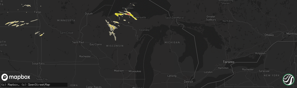
Hail Map in Michigan on July 18, 2022
The weather event in Michigan on July 18, 2022 includes Wind, Hail, and Tornado maps. 21 states and 342 cities were impacted and suffered possible damage. The total estimated number of properties impacted is 2,376.
Want more than just the map?
Turn this storm into a full workflow.
- Owner + property data so you know who to knock
- OnDemand branded weather history reports to win the "did we even have hail?" argument
- RoofTrace estimate so reps stop guessing numbers at the door
Bought this map? Upgrade within 7 days and we'll credit the $230. (10-15 min setup call)
Wind
Hail
Tornado
2,376
Estimated number of impacted properties by a 1.00" hail or larger472
Estimated number of impacted properties by a 1.75" hail or larger311
Estimated number of impacted properties by a 2.50" hail or largerStorm reports in Michigan
Michigan
| Date | Description |
|---|---|
| 07/18/20226:36 AM CDT | At 1135 PM EDT, a severe thunderstorm was located over Rockland, or 12 miles southeast of Ontonagon, moving southeast at 50 mph. HAZARD...Golf ball size hail and 60 mph wind gusts. SOURCE...Radar indicated. IMPACT...People and animals outdoors will be injured. Expect hail damage to roofs, siding, windows, and vehicles. Expect wind damage to roofs, siding, and trees. This severe thunderstorm will be near... Mass City around 1140 PM EDT.Other locations in the path of this severe thunderstorm includeKenton. |
| 07/18/20226:24 AM CDT | At 1123 PM EDT, a severe thunderstorm was located 7 miles southeast of Porcupine Mountains State Park, moving southeast at 35 mph. HAZARD...60 mph wind gusts and quarter size hail. SOURCE...Radar indicated. IMPACT...Hail damage to vehicles is expected. Expect wind damage to roofs, siding, and trees. This severe thunderstorm will be near... Bergland around 1135 PM EDT. |
| 07/18/20222:32 AM CDT | From facebook. |
| 07/18/20222:19 AM CDT | Picture on facebook showing hail measured via ruler. Largest stone between a nickel and quarter. |
| 07/18/20221:55 AM CDT | Facebook comment of hail sizes ranging from pea to quarter. Time estimated by radar. |
| 07/18/20221:33 AM CDT | Facebook user shared pictures of tree down on road and on a primary. Power out. Time of damage estimated by radar. |
| 07/17/202211:27 PM CDT | Video and photos from facebook user of the hail. A photo shows golf ball sized hail in hand. |
| 07/17/202211:25 PM CDT | From twitter user. |
| 07/17/202211:25 PM CDT | Facebook photo of hail stone in hand. Comments that it was about baseball sized. Time estimated by radar. |
| 07/17/202211:20 PM CDT | Shows a couple of pictures of hail... Some golf ball sized in his hand. From facebook. |
| 07/17/202211:15 PM CDT | Trees and powerlines down along bay shore and pequamming roads. |
| 07/17/202210:40 PM CDT | Facebook comment on largest hail size seen during storm. Most were around quarter sized. Time estimated by radar. |
| 07/17/202210:40 PM CDT | Got hail for 5 minutes. Ending by the end of phone call. |
All States Impacted by Hail Map on July 18, 2022
Cities Impacted by Hail Map on July 18, 2022
- Walhalla, ND
- Hays, MT
- Palermo, ND
- Stanley, ND
- Ross, ND
- Forbes, ND
- Ashley, ND
- Ellendale, ND
- Walkersville, MD
- Frederick, MD
- Ranson, WV
- Charles Town, WV
- Bunker Hill, WV
- Summit Point, WV
- Inwood, WV
- Kearneysville, WV
- Clear Brook, VA
- Newberry Springs, CA
- Peach Bottom, PA
- Nottingham, PA
- Clinton, MN
- Corona, SD
- Big Stone City, SD
- Ortonville, MN
- Oakes, ND
- Portal, ND
- Brockton, MT
- Poplar, MT
- Souris, ND
- Grand Marais, MN
- Flaxton, ND
- Kenmare, ND
- Bowbells, ND
- Minto, ND
- Middletown, MD
- Jefferson, MD
- Dunseith, ND
- Valier, MT
- Conrad, MT
- Mass City, MI
- Ewen, MI
- Rockland, MI
- White Pine, MI
- Ontonagon, MI
- Hickory Ridge, AR
- Harlem, MT
- Wildrose, ND
- Hoople, ND
- Crystal, ND
- Edinburg, ND
- Grand Portage, MN
- Trout Creek, MI
- Iron River, MI
- Peever, SD
- Veblen, SD
- Shepherdstown, WV
- Sharpsburg, MD
- Powers Lake, ND
- Columbus, ND
- Dazey, ND
- Luverne, ND
- Dumont, MN
- Butternut, WI
- Chassell, MI
- Mechanicsville, MD
- Noonan, ND
- Lancaster, MN
- Beardsley, MN
- Centreville, MD
- Max, NE
- Tappen, ND
- Minot, ND
- Glenburn, ND
- Stratton, NE
- Badger, MN
- Greenbush, MN
- Roseau, MN
- Saint Thomas, ND
- Drayton, ND
- Hinsdale, MT
- Larslan, MT
- Opheim, MT
- Richland, MT
- Peerless, MT
- Glentana, MT
- Marianna, AR
- Spiritwood, ND
- Bottineau, ND
- Burlington, ND
- Des Lacs, ND
- Surrey, ND
- Boulder Junction, WI
- Manitowish Waters, WI
- Fullerton, ND
- Bruce Crossing, MI
- Iron Belt, WI
- Shelby, MT
- Shenandoah Junction, WV
- Mohawk, MI
- Oxford, PA
- Cogswell, ND
- Forman, ND
- Leroy, AL
- Wagarville, AL
- Wales, ND
- Malta, MT
- Cut Bank, MT
- Ledger, MT
- Donnybrook, ND
- Kramer, ND
- Ray, ND
- Grenora, ND
- Homestead, MT
- Carpio, ND
- Upham, ND
- Williston, ND
- Dagmar, MT
- Zahl, ND
- Alamo, ND
- Mohall, ND
- Tioga, ND
- Medicine Lake, MT
- Mcgregor, ND
- Froid, MT
- Lansford, ND
- Epping, ND
- Crosby, ND
- Maxbass, ND
- Bainville, MT
- White Earth, ND
- Newburg, ND
- Hannah, ND
- Rocklake, ND
- Hope, ND
- Page, ND
- Galesburg, ND
- Big Sandy, MT
- Lloyd, MT
- Berthold, ND
- Leola, SD
- Zortman, MT
- Antelope, MT
- Crystal Falls, MI
- Arvilla, ND
- Emerado, ND
- Frederick, SD
- Cavalier, ND
- Scobey, MT
- Wolf Point, MT
- Flaxville, MT
- Bronx, NY
- Pelham, NY
- New Rochelle, NY
- Mercer, WI
- Lake Tomahawk, WI
- Lac Du Flambeau, WI
- Minocqua, WI
- Saint Germain, WI
- Woodruff, WI
- Phillips, WI
- Tripoli, WI
- Park Falls, WI
- Hazelhurst, WI
- Baltimore, MD
- Nottingham, MD
- Rosedale, MD
- Lamar, CO
- Wiley, CO
- Tucson, AZ
- Mill Neck, NY
- Glen Cove, NY
- Bayville, NY
- Huntington, NY
- Oyster Bay, NY
- Locust Valley, NY
- Plaza, ND
- Circle, MT
- Vida, MT
- Tunica, MS
- Harpers Ferry, WV
- Cliffside Park, NJ
- Leonia, NJ
- Edgewater, NJ
- Ridgefield, NJ
- Fort Lee, NJ
- Palisades Park, NJ
- Milnor, ND
- Langdon, ND
- Calvin, ND
- Whitetail, MT
- Park River, ND
- Halma, MN
- Lake Bronson, MN
- Hannaford, ND
- Greenville, SC
- Piedmont, SC
- Easley, SC
- Chokio, MN
- Grand Forks Afb, ND
- Mekinock, ND
- Sisseton, SD
- Arlington, AL
- Queenstown, MD
- Trinidad, CO
- Colfax, ND
- Barney, ND
- Wyndmere, ND
- Wahpeton, ND
- West Point, MS
- Starkville, MS
- Ogema, WI
- Oriska, ND
- Pageland, SC
- Jefferson, SC
- Oakland, MS
- Como, MS
- Tomahawk, WI
- Fulton, MS
- Crossville, AL
- Georgiana, AL
- Greenville, AL
- Wishek, ND
- Lanse, MI
- Antler, ND
- Conover, WI
- Eagle River, WI
- Inkster, ND
- Saltillo, MS
- Mooreville, MS
- Mantachie, MS
- Tupelo, MS
- Eureka, SD
- Herreid, SD
- McCrory, AR
- Benkelman, NE
- Hamilton, AL
- Tremont, MS
- Hackleburg, AL
- Hodges, AL
- Vina, AL
- Aberdeen, MS
- Okolona, MS
- Pelkie, MI
- Fredonia, ND
- Kulm, ND
- Berlin, ND
- Lehr, ND
- Edgeley, ND
- Daggett, CA
- Yermo, CA
- Belden, MS
- Presque Isle, WI
- Marks, MS
- Lambert, MS
- Charleston, MS
- Enid, MS
- Batesville, MS
- Saco, MT
- Whitewater, MT
- Reserve, MT
- Manvel, ND
- Oslo, MN
- Atlantic Mine, MI
- Painesdale, MI
- Irma, WI
- Rib Lake, WI
- Merrill, WI
- Brantwood, WI
- Prentice, WI
- Lake Linden, MI
- Guntown, MS
- Nisula, MI
- Baraga, MI
- Ishpeming, MI
- Toivola, MI
- Michigamme, MI
- Champion, MI
- Republic, MI
- Crenshaw, MS
- Pope, MS
- Sledge, MS
- Tutwiler, MS
- Sardis, MS
- Patagonia, AZ
- Nogales, AZ
- Marenisco, MI
- Land O'Lakes, WI
- Jackson, AL
- Senatobia, MS
- Browns Valley, MN
- Borup, MN
- Ada, MN
- Mellen, WI
- Upson, WI
- Wakefield, MI
- Watersmeet, MI
- Covington, MI
- Lamoure, ND
- Verona, ND
- Lovettsville, VA
- Coffeeville, MS
- Water Valley, MS
- Pinetop, AZ
- Columbus, MS
- Purcellville, VA
- Middleburg, VA
- Leesburg, VA
- Thomaston, AL
- Ambrose, ND
- Fortuna, ND
- Bergland, MI
- Glidden, WI
- Glenwood, MN
- Richey, MT
- Dupree, SD
- Saint John, ND
- Grafton, ND
- Sunburst, MT
- Kevin, MT
- Oilmont, MT
- Galata, MT
- Vergennes, VT
- Karlstad, MN
- Nashua, MT
- Frazer, MT
- Vandalia, MT
- Fort Peck, MT
- Glasgow, MT
- Redstone, MT
- Lignite, ND
- Sherwood, ND
- Tolley, ND
- Perth, ND
- Hansboro, ND
- Maida, ND
- Bisbee, ND
- Belcourt, ND
- Mylo, ND
- Sarles, ND
- Munich, ND
- Rolla, ND
- Egeland, ND


