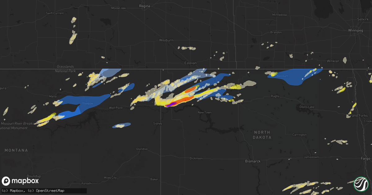
Hail Map on July 18, 2022
Get this storm
July 18 map
$229
one time, instant access
Download today. No call, no setup
Keep the $229
Bought the map and want the full workflow? Apply the entire $229 to a subscription within 7 days. None of it is wasted.
Every map, not just this one
This buys you this map. Subscription and you get every map we run, in the markets you choose from a few cities to whole states to nationwide. Plus real-time alerts the moment a storm fires.
Contact data
Name, contact info, occupancy, even credit band for addresses in the footprint. You go from where it hit to who to call.
Become the source they trust
Unlimited branding weather history reports on demand. You already have the documented answer ready for the property owner, and you are the one who showed up with it.
Property data and RoofTrace estimates
Pull up any address you have got, its value and the exact code rules for that jurisdiction, straight from One Click Code. Then RoofTrace estimates the squares, pitch, and roof value, priced the way you price.
States Impacted by Hail Map on July 18, 2022
Storm reports
Florida
| Date | Description |
|---|---|
| 07/18/202212:56 AM CDT | At 556 PM CDT, severe thunderstorms were located along a line extending from 7 miles southeast of Jackson to 8 miles northeast of McIntosh, moving southeast at 20 mph. HAZARD...60 mph wind gusts and quarter size hail. SOURCE...Radar indicated. IMPACT...Hail damage to vehicles is expected. Expect wind damage to roofs, siding, and trees. Locations impacted include... McCullough, Uriah, I65 And CR 1, I65 And AL 21 and Poarch Creek Reservation. |
South Dakota
| Date | Description |
|---|---|
| 07/18/20224:33 PM CDT | A local report indicates 58 MPH wind near 1 WSW RED ELM |
| 07/18/20221:47 AM CDT | At 647 PM CDT/547 PM MDT/, a severe thunderstorm was located near Tiospaye Topa School, or 22 miles south of Mobridge, moving northeast at 30 mph. HAZARD...60 mph wind gusts and nickel size hail. SOURCE...Radar indicated. IMPACT...Expect damage to roofs, siding, and trees. This severe thunderstorm will be near... Promise around 550 PM MDT.Other locations in the path of this severe thunderstorm includeBlackfoot, Swan Creek Rec Area and New Everets Resort. |
Minnesota
| Date | Description |
|---|---|
| 07/18/20221:49 PM CDT | Trees down on long lake on lake vermilion. Delayed report. Time estimated from radar. |
| 07/18/20222:40 AM CDT | A local report indicates 1.00 inch wind near 3 N ROSEAU |
| 07/18/20222:15 AM CDT | Wind and hail impacted portions of eastern cannon township... Over a mix of farmland and wildlife management area. Time estimated based on radar. |
| 07/18/20221:12 AM CDT | At 611 AM CDT, severe thunderstorms were located along a line extending from 9 miles northeast of Long Point to Arnesen to near Swift, moving southeast at 35 mph. HAZARD...60 mph wind gusts and quarter size hail. SOURCE...Radar indicated. IMPACT...Hail damage to vehicles is expected. Expect wind damage to roofs, siding, and trees. Severe thunderstorms will be near... Birch Beach, Lude and Long Point around 620 AM CDT. Williams around 630 AM CDT.Other locations in the path of these severe thunderstorms includeWheelers Point, Graceton, Pitt and Baudette. |
| 07/18/202212:32 AM CDT | At 532 AM CDT, a severe thunderstorm was located near Pinecreek, or 9 miles northwest of Roseau, moving southeast at 45 mph. HAZARD...Quarter size hail. SOURCE...Radar indicated. IMPACT...Damage to vehicles is expected. This severe thunderstorm will be near... Roseau around 545 AM CDT.Other locations in the path of this severe thunderstorm includeSalol. |
Wyoming
| Date | Description |
|---|---|
| 07/17/20227:24 PM CDT | A local report indicates 67 MPH wind near 8 NW ROCKYPOINT |
New Jersey
| Date | Description |
|---|---|
| 07/18/20221:49 PM CDT | Large tree branch down on wires. |
| 07/17/20229:16 PM CDT | At 216 PM EDT, a severe thunderstorm was located over Hawthorne, or over Paterson, moving east at 30 mph. HAZARD...60 mph wind gusts and penny size hail. SOURCE...Radar indicated. IMPACT...Expect damage to trees and power lines. This severe thunderstorm will be near... Ridgewood around 220 PM EDT. Hackensack and Paramus around 225 PM EDT. Oradell around 230 PM EDT. Bergenfield and Englewood around 235 PM EDT. Tappan and Riverdale around 240 PM EDT. Nyack and Orangeburg around 245 PM EDT. Yonkers and Dobbs Ferry around 250 PM EDT. New Rochelle and Tarrytown around 255 PM EDT. White Plains and Scarsdale around 300 PM EDT. |
Maine
| Date | Description |
|---|---|
| 07/18/20221:23 AM CDT | At 622 PM EDT, a severe thunderstorm was located near Hiram, or 10 miles southwest of Naples, moving northeast at 35 mph. HAZARD...60 mph wind gusts and penny size hail. SOURCE...Radar indicated. IMPACT...Expect damage to roofs, siding, and trees. Locations impacted include... Bridgton, Mechanic Falls, Naples, Gray, Hiram, Cornish, Raymond, Standish, Casco, Harrison, Denmark, Frye Island, Sebago, New Gloucester, Baldwin, Poland, Oxford, Porter, Otisfield and Windham.This includes Interstate 95 between mile markers 66 and 73. |
North Dakota
| Date | Description |
|---|---|
| 07/18/20226:59 AM CDT | At 1158 PM CDT, a severe thunderstorm was located near Epping, or 19 miles northeast of Williston, moving east at 45 mph. HAZARD...Golf ball size hail and 70 mph wind gusts. SOURCE...Public. This storm has a history of producing golf ball size hail in Williston. IMPACT...People and animals outdoors will be injured. Expect hail damage to roofs, siding, windows, and vehicles. Expect considerable tree damage. Wind damage is also likely to mobile homes, roofs, and outbuildings. This severe thunderstorm will be near... Ray around 1205 AM CDT. Tioga around 1220 AM CDT. Powers Lake around 1240 AM CDT.Other locations impacted by this severe thunderstorm include WhiteTail Bay Recreation Area, White Earth, Mcgregor, Lewis And ClarkState Park, Spring Brook and Wheelock. |
| 07/18/20226:30 AM CDT | At 1130 PM CDT, a severe thunderstorm was located 13 miles east of Bowbells, moving northeast at 45 mph. HAZARD...70 mph wind gusts and penny size hail. SOURCE...Radar indicated. IMPACT...Expect considerable tree damage. Damage is likely to mobile homes, roofs, and outbuildings. Locations impacted include... Sherwood. |
| 07/18/20226:15 AM CDT | At 1115 PM CDT, a severe thunderstorm was located near Battleview, or 26 miles northwest of Stanley, moving northeast at 40 mph. HAZARD...Golf ball size hail and 70 mph wind gusts. SOURCE...Radar indicated. IMPACT...People and animals outdoors will be injured. Expect hail damage to roofs, siding, windows, and vehicles. Expect considerable tree damage. Wind damage is also likely to mobile homes, roofs, and outbuildings. This severe thunderstorm will be near... Powers Lake around 1125 PM CDT.Other locations in the path of this severe thunderstorm includeBowbells. |
| 07/18/20225:53 AM CDT | Nickel to quarter sized hail and very heavy rains. |
| 07/18/20225:14 AM CDT | Large 3 to 5 inch diameter tree branches broken down around town. |
| 07/18/20225:13 AM CDT | At 1010 PM CDT, a severe thunderstorm was located 5 miles northwest of Wildrose, or 14 miles south of Crosby, moving northeast at 55 mph. HAZARD...70 mph wind gusts and quarter size hail. SOURCE...Radar indicated. At 1007 PM CDT a 60 mph gust was reported 2 miles south of Alamo. IMPACT...Hail damage to vehicles is expected. Expect considerable tree damage. Wind damage is also likely to mobile homes, roofs, and outbuildings. This severe thunderstorm will be near... Noonan around 1030 PM CDT.Other locations in the path of this severe thunderstorm includeColumbus, Lignite, Portal and Flaxton. |
| 07/18/20225:00 AM CDT | One large tree blown down at the mt. Carmel rec area. |
| 07/18/20224:55 AM CDT | Peak wind measured at the langdon airport /kd55/. |
| 07/18/20224:55 AM CDT | Awos station kd55 langdon ap nd. |
| 07/18/20224:45 AM CDT | Report of tree branches down as large as 5 inches in diameter near maida via social media. Time estimated from radar. |
| 07/18/20224:40 AM CDT | Corrected location. Report of tree branches down as large as 5 inches in diameter along the canadian border near mowbray. Report posted via social media. Time estimated |
| 07/18/20224:35 AM CDT | Roofing and wall panels blown off a poleshed. Large tree branches and limbs broken down. |
| 07/18/20224:18 AM CDT | Public report of a large cottonwood tree uprooted near sarles. Report and photo posted via social media. Time estimated based on radar and nearby wind sensor reports. |
| 07/18/20224:15 AM CDT | Peak wind measured at the cando airport /k9d7/. |
| 07/18/20224:15 AM CDT | Awos station k9d7 cando ap nd. |
| 07/18/20224:15 AM CDT | Corrected for time. Public report of a large cottonwood tree uprooted near sarles. Report and photo posted via social media. Time estimated based on radar and nearby wi |
| 07/18/20224:03 AM CDT | Ndawn 10m wind gust of 70mph and 3m wind gust of 60mph |
| 07/18/20223:55 AM CDT | Awos station k06d rolla nd awos. |
| 07/18/20223:42 AM CDT | Grain bins damaged with debris blown to the north. |
| 07/18/20223:42 AM CDT | Based on information provided by the rolette county emergency manager... Including photos and in speaking with him... And radar data... It was determined that thunderst |
| 07/18/20223:40 AM CDT | A local report indicates 1.00 inch wind near 5 N WALES |
| 07/18/20223:38 AM CDT | Delayed report. Raws station tmtn8 4 sw belcourt. |
| 07/18/20222:47 AM CDT | Report from mping: half dollar |
| 07/18/20222:20 AM CDT | Hail and very strong winds. Numerous large 3 to 5 inch diameter tree branches broken down. |
| 07/18/20222:15 AM CDT | Report relayed through broadcast media. Time estimated based on radar. |
| 07/18/20221:54 AM CDT | Peak wind measured at a personal weather station. |
| 07/18/20221:30 AM CDT | Report and photo posted via social media. |
| 07/18/202212:50 AM CDT | Relayed through social media. Photo of hailstone approximately the size of a half dollar. |
| 07/18/202212:08 AM CDT | Relayed through broadcast media. Report of golf ball sized hail. |
| 07/18/202212:05 AM CDT | Mesonet station 327380 3 n ray |
| 07/17/202211:53 PM CDT | At 453 PM MDT, a severe thunderstorm was located 13 miles west of Richey, or 18 miles northeast of Circle, moving east at 55 mph. HAZARD...60 mph wind gusts and quarter size hail. SOURCE...Radar indicated. IMPACT...Hail damage to vehicles is expected. Expect wind damage to roofs, siding, and trees. Locations impacted include... Sidney, Fairview, Richey, Lambert, Savage, East Fairview, Enid, Midway, Wooley, Burns and Crane. |
| 07/17/202211:40 PM CDT | Numerous reports of large... Damaging hail from the city of williston. Public submitted photos show hail ranging generally from golf ball to tennis ball size... With a |
| 07/17/202211:37 PM CDT | Delayed report. Multiple pictures of hail measured with ruler relayed via social media. Time estimate via radar. |
| 07/17/202211:35 PM CDT | Report from mping: quarter |
| 07/17/202211:35 PM CDT | Ping pong ball sized hail falling at time of report. |
| 07/17/202211:20 PM CDT | Mesonet station 320989 1 nne bowbells |
| 07/17/202211:09 PM CDT | Us air force weather station 1.5 sw of bowbells. |
| 07/17/202211:05 PM CDT | Time estimated from radar. |
| 07/17/202210:33 PM CDT | Ndawn station measured sustained 60 mph and a gust to 79 mph. |
| 07/17/202210:23 PM CDT | Ndawn mesonet station. |
| 07/17/202210:20 PM CDT | Em and public report and pictures of significant damage in wildrose. Damage includes lots of large trees uprooted and blocking streets... Multiple open stand buildings |
| 07/17/202210:15 PM CDT | From july 18 - based on information provided by the williams county emergency manager and area residents... Including many photos and in speaking with them... And radar |
| 07/17/202210:15 PM CDT | Large 6 to 10 inch diamter tree branches broken down... Barn window panes blown in... And a couple of power poles tilted across northcentral galesburg township. |
| 07/17/202210:07 PM CDT | Gust measured from ndawn mesonet station. |
| 07/17/20229:45 PM CDT | Measured by a personal weather station. |
| 07/17/20229:44 PM CDT | Estimated 60 mph gusts with initial push of wind. Time estimated from radar. |
| 07/17/20229:13 PM CDT | Measured from ndawn station. |
Virginia
| Date | Description |
|---|---|
| 07/18/20226:03 PM CDT | Tree down on teas rd. |
| 07/18/20225:48 PM CDT | Tree down on morris rd. |
| 07/18/20225:45 PM CDT | Several trees down. |
| 07/18/20225:36 PM CDT | Tree down on railroad avenue. |
| 07/18/20225:14 PM CDT | Tree down in 8000 block of goodview rd. |
| 07/18/20225:05 PM CDT | Several trees down. |
| 07/18/20224:55 PM CDT | Tree down near the intersection of montgomery lane and long run rd. |
| 07/18/20224:40 PM CDT | One tree down in the vicinity of fort chiswell road and brower lane. |
| 07/18/20224:35 PM CDT | One tree down across the roadway due to thunderstorm winds near the intersection of gus w nicks boulevard and orange avenue. |
| 07/18/20223:52 PM CDT | A couple of trees and power line down in the pearsiburg area. |
| 07/18/20223:52 PM CDT | A couple of trees and power lines down in the pearsiburg area. |
| 07/18/20223:43 PM CDT | Tree down on a house on porter road approximately 2 miles west-southwest of narrows. |
| 07/18/20223:38 PM CDT | Numerous trees and a couple of power lines down along virginia highway 61 and along side wolf creek between wolf creek and narrows. Radar estimated time of these events |
| 07/18/20222:51 PM CDT | Numerous trees blew down just southwest of leesburg. Trees and a lightpost blew over near the intersection of us-15 james monroe highway and woodlea drive southwest. Tr |
| 07/18/20222:50 PM CDT | Trees blew down near the intersection of va-797 mount gilead road and va-704 harmony church road. |
| 07/18/20222:46 PM CDT | Trees and wires blew down along us-50 john mosby highway near va-748 sam fred road/melmore place. |
| 07/18/20222:22 PM CDT | A tree blew down near milldale rd and morgan ford rd. |
| 07/18/20222:10 PM CDT | Trees blew down along va-672 lovettsville road. |
| 07/18/20222:05 PM CDT | Several trees blew down near madison rd and dundee rd. |
| 07/18/20222:03 PM CDT | A tree blew down near south river rd and octonia rd. |
| 07/18/20221:44 PM CDT | A tree blew down near the intersection of town hall ave and park rd in edinburg. |
| 07/18/20221:33 PM CDT | A tree blew down near conicville rd and senedo rd. |
| 07/18/20222:29 AM CDT | At 728 PM EDT, a severe thunderstorm was located over Bridle Creek, or near Mouth Of Wilson, moving east at 30 mph. HAZARD...60 mph wind gusts and quarter size hail. SOURCE...Radar indicated. IMPACT...Hail damage to vehicles is expected. Expect wind damage to roofs, siding, and trees. Locations impacted include... Sparta... Independence... Laurel Springs... Ennice... Mouth Of Wilson... Troutdale... and Volney. |
| 07/18/20221:16 AM CDT | At 616 PM EDT, a severe thunderstorm was located near Peaks Of Otter Recreation Area, or near Buchanan, moving northeast at 15 mph. HAZARD...60 mph wind gusts. SOURCE...Radar indicated. IMPACT...Expect damage to roofs, siding, and trees. Locations impacted include... Big Island... Coleman Falls... Arcadia... Snowden... Peaks Of Otter Summit... Peaks Of Otter Recreation Area... and Sedalia. |
| 07/18/20221:08 AM CDT | At 608 PM EDT, severe thunderstorms were located along a line extending from 7 miles southeast of Abingdon to near Mountain City to 7 miles west of Peoria, moving northeast at 25 mph. HAZARD...60 mph wind gusts. SOURCE...Radar indicated. IMPACT...Expect damage to roofs, siding, and trees. Locations impacted include... Mountain City, Trade, Doeville, Neva, Shady Valley and Laurel Bloomery. |
| 07/17/202210:02 PM CDT | At 302 PM EDT, a severe thunderstorm was located near Strasburg, moving northeast at 35 mph. HAZARD...60 mph wind gusts. SOURCE...Radar indicated. IMPACT...Damaging winds will cause some trees and large branches to fall. This could injure those outdoors, as well as damage homes and vehicles. Roadways may become blocked by downed trees. Localized power outages are possible. Unsecured light objects may become projectiles. Locations impacted include... Front Royal, Strasburg, Berryville, Delaplane, Linden, Middletown, Maurertown, Boyce, Toms Brook, White Post, Seven Fountains, Riverton, Karo, Blue Mountain, Nineveh, Bethel, Clary, Fort Valley, Howellsville and Dilbeck. |
| 07/17/20229:44 PM CDT | At 243 PM EDT, severe thunderstorms were located along a line extending from 7 miles west of Stanardsville to near Free Union to near Afton, moving east at 30 mph. HAZARD...60 mph wind gusts. SOURCE...Radar indicated. IMPACT...Damaging winds will cause some trees and large branches to fall. This could injure those outdoors, as well as damage homes and vehicles. Roadways may become blocked by downed trees. Localized power outages are possible. Unsecured light objects may become projectiles. Locations impacted include... Madison, Crozet, Stanardsville, Free Union, Westmoreland, Hollymead, Ruckersville, Ivy, Quinque, Eheart, Lydia, Yancey Mills, Stony Point, Haneytown, Newtown, Amicus, Shady Grove, Hood, Mcmullen and Boonesville. |
Pennsylvania
| Date | Description |
|---|---|
| 07/17/202211:40 PM CDT | At 439 PM EDT, severe thunderstorms were located along a line extending from near Kettle Creek Gorge to Muncy Valley to Lairdsville, moving east at 50 mph. HAZARD...60 mph wind gusts. SOURCE...Radar indicated. IMPACT...Expect damage to roofs, siding, and trees. Locations impacted include... Jamison City, Waller, Biggertown, Lairdsville, Ricketts Glen State Park, Central, Muncy Valley, Dushore, Laporte, Forksville and Eagles Mere.This includes the following highways... Route 220 from Muncy Valley to north of Dushore. State Road 118 from Lairdsvile to west of Red Rock. |
Arkansas
| Date | Description |
|---|---|
| 07/18/20227:19 AM CDT | At 1217 AM CDT, severe thunderstorms were located along a line extending from Dover to 7 miles north of Danville to 5 miles southeast of Blue Mountain, moving southeast at 40 mph. HAZARD...60 mph wind gusts and penny size hail. SOURCE...Radar indicated. IMPACT...Expect damage to roofs, siding, and trees. Locations impacted include... Russellville... Morrilton... Danville... Perryville... Dardanelle... Atkins... Pottsville... Dover... Ola... Oppelo... Perry... Adona... Sequoya Park... Lake Dardanelle State Park... Happy Bend... Petit Jean River WMA... Mosley... Taral... Stonehouse Recreation Area... Carden Bottoms...This includes Interstate 40 between mile markers 79 and 112. |
| 07/17/20229:56 PM CDT | At 256 AM CDT, severe thunderstorms were located along a line extending from near Roe to near Stuttgart to 8 miles northeast of Richardson, moving east at 40 mph. HAZARD...60 mph wind gusts. SOURCE...Radar indicated. IMPACT...Expect damage to roofs, siding, and trees. Locations impacted include... Stuttgart... Gillett... Holly Grove... Almyra... St. Charles... Ulm... Roe... Merrisach Lake... Palmer... Stuttgart Municipal Airport... De Witt... Aberdeen... De Luce... Slovak... Almyra Airport... Casscoe... Tichnor... Lodge Corner... Weber... Cross Roads in Monroe County... |
| 07/17/20229:13 PM CDT | At 212 AM CDT, a severe thunderstorm was located near Hensley Island, or 17 miles north of Pine Bluff, moving southeast at 40 mph. HAZARD...60 mph wind gusts. SOURCE...Radar indicated. IMPACT...Expect damage to roofs, siding, and trees. Locations impacted include... Pine Bluff... Stuttgart... White Hall... England... Redfield... Altheimer... Humphrey... Grady... Humnoke... Keo... Ulm... Cottondale... Brummitt... Linwood... Pine Bluff Arsenal... Madding... Warbritton... Langford... Richardson... Hensley Island...This includes Interstate 530 between mile markers 18 and 25, andbetween mile markers 42 and 46. |
| 07/17/20228:04 PM CDT | At 103 AM CDT, severe thunderstorms were located along a line extending from near Houston to near Wye Mountain to near Williams Junction, moving southeast at 40 mph. HAZARD...60 mph wind gusts and penny size hail. SOURCE...Radar indicated. IMPACT...Expect damage to roofs, siding, and trees. Locations impacted include... Little Rock... North Little Rock... Conway... Sherwood... Jacksonville... West Little Rock... Maumelle... Bryant... Downtown Little Rock... Perryville... North Little Rock Airport... Southwest Little Rock... Little Rock AFB... Shannon Hills... Mayflower... Argenta... Perry... Houston... Otter Creek... Little Italy...This includes the following highways... Interstate 30 between mile markers 123 and 142. Interstate 40 between mile markers 133 and 157. Interstate 430 between mile markers 1 and 12. Interstate 530 between mile markers 1 and 5. Interstate 630 between mile markers 1 and 7. Interstate 440 between mile markers 1 and 4. US Highway 67 between mile markers 1 and 4. |
West Virginia
| Date | Description |
|---|---|
| 07/18/20221:28 PM CDT | A tree blew down near williamsport pike and weaver ln. |
| 07/18/20221:28 PM CDT | Wind damage was reported near berkeley. Wires and a pole were knocked over near the intersection of us-11 williamsport pike and mid atlantic parkway. A tree blew down n |
| 07/18/202211:12 AM CDT | Corrects previous tstm wnd dmg report from coal city. Updates previous tstm wnd dmg report from coal city. Numerous trees and power lines down in a small area within co |
| 07/18/202211:12 AM CDT | Numerous trees and power lines down in the area of coal city... Wv. Reports of a tree on a trailer... Possibly destroying it. |
| 07/18/202211:12 AM CDT | Updates previous tstm wnd dmg report from coal city. Numerous trees and power lines down in a small area within coal city... Wv. Roads blocked. Reports of a tree down o |
| 07/17/202211:38 PM CDT | At 437 PM EDT, a severe thunderstorm was located over Chapel, or near Narrows, moving east at 30 mph. HAZARD...60 mph wind gusts and quarter size hail. SOURCE...Radar indicated. IMPACT...Hail damage to vehicles is expected. Expect wind damage to roofs, siding, and trees. Locations impacted include... Pearisburg... Narrows... Pembroke... Peterstown... Poplar Hill... Mountain Lake... and Rich Creek. |
| 07/17/20228:59 PM CDT | At 159 PM EDT, a severe thunderstorm was located near Star Tannery, or 10 miles west of Winchester, moving east at 30 mph. HAZARD...60 mph wind gusts. SOURCE...Radar indicated. IMPACT...Damaging winds will cause some trees and large branches to fall. This could injure those outdoors, as well as damage homes and vehicles. Roadways may become blocked by downed trees. Localized power outages are possible. Unsecured light objects may become projectiles. Locations impacted include... Winchester, Millwood Pike, Berryville, Inwood, Middleway, High View, Cedar Grove, Gaylord, Clear Brook, Ridgeway, Bunker Hill, Stephenson, Cedar Hill, Albin, Gore, Stringtown, Brucetown, Greenwood, High View Manor and Gainesboro. |
Michigan
| Date | Description |
|---|---|
| 07/18/20226:36 AM CDT | At 1135 PM EDT, a severe thunderstorm was located over Rockland, or 12 miles southeast of Ontonagon, moving southeast at 50 mph. HAZARD...Golf ball size hail and 60 mph wind gusts. SOURCE...Radar indicated. IMPACT...People and animals outdoors will be injured. Expect hail damage to roofs, siding, windows, and vehicles. Expect wind damage to roofs, siding, and trees. This severe thunderstorm will be near... Mass City around 1140 PM EDT.Other locations in the path of this severe thunderstorm includeKenton. |
| 07/18/20226:24 AM CDT | At 1123 PM EDT, a severe thunderstorm was located 7 miles southeast of Porcupine Mountains State Park, moving southeast at 35 mph. HAZARD...60 mph wind gusts and quarter size hail. SOURCE...Radar indicated. IMPACT...Hail damage to vehicles is expected. Expect wind damage to roofs, siding, and trees. This severe thunderstorm will be near... Bergland around 1135 PM EDT. |
| 07/18/20222:32 AM CDT | From facebook. |
| 07/18/20222:19 AM CDT | Picture on facebook showing hail measured via ruler. Largest stone between a nickel and quarter. |
| 07/18/20221:55 AM CDT | Facebook comment of hail sizes ranging from pea to quarter. Time estimated by radar. |
| 07/18/20221:33 AM CDT | Facebook user shared pictures of tree down on road and on a primary. Power out. Time of damage estimated by radar. |
| 07/17/202211:27 PM CDT | Video and photos from facebook user of the hail. A photo shows golf ball sized hail in hand. |
| 07/17/202211:25 PM CDT | Facebook photo of hail stone in hand. Comments that it was about baseball sized. Time estimated by radar. |
| 07/17/202211:25 PM CDT | From twitter user. |
| 07/17/202211:20 PM CDT | Shows a couple of pictures of hail... Some golf ball sized in his hand. From facebook. |
| 07/17/202211:15 PM CDT | Trees and powerlines down along bay shore and pequamming roads. |
| 07/17/202210:40 PM CDT | Got hail for 5 minutes. Ending by the end of phone call. |
| 07/17/202210:40 PM CDT | Facebook comment on largest hail size seen during storm. Most were around quarter sized. Time estimated by radar. |
Mississippi
| Date | Description |
|---|---|
| 07/18/20225:44 AM CDT | At 1044 PM CDT, a severe thunderstorm was located near Crowder, or 11 miles northwest of Charleston, moving south at 15 mph. HAZARD...60 mph wind gusts and quarter size hail. SOURCE...Radar indicated. IMPACT...Hail damage to vehicles is expected. Expect wind damage to roofs, siding, and trees. Locations impacted include... Charleston, Marks, Lambert, Crowder, Vance, Waverly, Brazil, Denton and Stover. |
| 07/18/20224:58 AM CDT | At 958 PM CDT, a severe thunderstorm was located near Marks, or 15 miles west of Batesville, moving north at 15 mph. HAZARD...60 mph wind gusts and quarter size hail. SOURCE...Radar indicated. IMPACT...Hail damage to vehicles is expected. Expect wind damage to roofs, siding, and trees. Locations impacted include... Marks, Lambert, Jonestown, Crowder, Sledge, Curtis Station, Belen, Darling, Falcon, West Marks, Mims, Riverview, Asa, Hinchcliff, Locke Station, Matagorda and Essex. |
| 07/18/20224:17 AM CDT | At 917 PM CDT, a severe thunderstorm was located over Crowder, or 12 miles northwest of Charleston, moving northwest at 15 mph. HAZARD...60 mph wind gusts and nickel size hail. SOURCE...Radar indicated. IMPACT...Expect damage to roofs, siding, and trees. Locations impacted include... Marks, Lambert, Crowder, West Marks, Sabino, Locke Station, Mims, Denton and Riverview. |
| 07/18/20222:30 AM CDT | A picture was relayed on social media for a home that received thunderstorm wind damage that occurred yesterday in pheba... Ms at 2:30 am near south beasley rd. The win |
| 07/17/20229:35 PM CDT | Quarter to half dollar size hail... Accompanied by 6 inches storm total rainfall over northern parts of the county. Time estimated by radar. |
| 07/17/20229:35 PM CDT | A few trees down across northern parts of the county. Time estimated by radar. |
Connecticut
| Date | Description |
|---|---|
| 07/17/20229:59 PM CDT | At 259 PM EDT, a severe thunderstorm was located over Scarsdale, or near Rye, moving east at 30 mph. HAZARD...60 mph wind gusts and penny size hail. SOURCE...Radar indicated. IMPACT...Expect damage to trees and power lines. This severe thunderstorm will be near... Rye around 305 PM EDT. Port Chester around 310 PM EDT. Darien around 330 PM EDT. |
Vermont
| Date | Description |
|---|---|
| 07/18/20225:52 PM CDT | Trees and property damage from photos received near the intersection of route 17 and 22a. |
| 07/18/20225:50 PM CDT | Nws survey confirmed an ef-1 tornado with maximum winds of 90 mph in addison vermont. Multiple trees were uprooted or snapped with many large limbs thrown about. The mo |
Colorado
| Date | Description |
|---|---|
| 07/18/20223:46 PM CDT | A local report indicates 1.25 inch wind near 2 SSW TRINIDAD |
| 07/17/202211:06 PM CDT | At 406 PM MDT, severe thunderstorms were located along a line extending from 8 miles south of Fountain to 7 miles northwest of Pueblo West, moving southeast at 20 mph. HAZARD...60 mph wind gusts and penny size hail. SOURCE...Radar indicated. IMPACT...Expect damage to roofs, siding, and trees. Locations impacted include... Pueblo, Fountain, Pueblo West, Pueblo Reservoir, Pinon and Hanover. |
| 07/17/20229:36 PM CDT | At 236 PM MDT, a severe thunderstorm was located over Starkville, or over Trinidad, moving northeast at 15 mph. HAZARD...60 mph wind gusts and quarter size hail. SOURCE...Radar indicated. IMPACT...Hail damage to vehicles is expected. Expect wind damage to roofs, siding, and trees. Locations impacted include... Trinidad, Starkville and Hoehne. |
Maryland
| Date | Description |
|---|---|
| 07/18/20226:26 PM CDT | Trees and wires down on md 304 east/west between safety drive and carville lane. Time estimated via radar. |
| 07/18/20226:20 PM CDT | Salthouse cove lane gusted to 67 mph. Time given in report. Weatherflow mesonet station. |
| 07/18/20226:20 PM CDT | Salthouse cove lane gusted to 67 mp |
| 07/18/20226:10 PM CDT | Corrects previous tstm wnd gst report from 1 nne queenstown. Changed estimated to measured. Salthouse cove lane mesonet reports 64 mph gust. Weatherflow station. Time o |
| 07/18/20226:10 PM CDT | Salthouse cove lane mesonet reports 64 mph gust. Weatherflow station. Time of gust given in report. |
| 07/18/20226:10 PM CDT | Wind gusts of up to 55 knots |
| 07/18/20225:16 PM CDT | Tree down in millington. Time estimated via radar. |
| 07/18/20224:03 PM CDT | A tree blew down near mill green rd and scarboro rd. |
| 07/18/20224:02 PM CDT | A tree blew down onto live wires near james run rd and tower rd. |
| 07/18/20223:59 PM CDT | Tree reported down on jerusalem road near valley brook drive. |
| 07/18/20223:57 PM CDT | A tree blew down near s tollgate rd and singer rd. |
| 07/18/20223:45 PM CDT | Tree damage was reported near parkville... Including a tree that blew down onto wires near the intersection of opal road and garnet road. |
| 07/18/20223:35 PM CDT | A tree blew down onto a commerical building in the 5500 block of nicholson lane. |
| 07/18/20223:32 PM CDT | Trees blew down north of cockeysville... Including one onto three cars on dove creek way. |
| 07/18/20223:30 PM CDT | A large tree two feet in diameter and numerous large tree limbs blew down near the intersection of international circle and international drive. |
| 07/18/20223:25 PM CDT | Trees and wires blew down near the intersection of oak street and maple avenue. |
| 07/18/20223:20 PM CDT | Trees and wires blew down near the intersection of shiloh road and wellesley court. |
| 07/18/20223:18 PM CDT | A tree blew down onto power lines near the 300 block of garrison forest rd. |
| 07/18/20223:17 PM CDT | Large trees and wires blew down near the intersection of the corral drive and burbank drive. |
| 07/18/20223:15 PM CDT | Trees and wires blew down near the intersection of md-482 hampstead mexico road near leisters church road. |
| 07/18/20223:05 PM CDT | Tree damage was reported near gamber... Including a tree that blew down in the 4200 block of london bridge road. |
| 07/18/20223:00 PM CDT | Trees blew down near the intersection of md-97 washington road and md-26 liberty road. |
| 07/18/20222:55 PM CDT | Tree damage was reported near winfield... Including a tree that blew down onto wires in the 3700 block of baker road. |
| 07/18/20222:50 PM CDT | Large tree limbs blew down... A gutter was blown off... And fencing blew down at a residence in the 7200 block of honeybush drive. |
| 07/18/20222:45 PM CDT | Trees blew down on westbo |
| 07/18/20222:45 PM CDT | Trees and wires blew down near the intersection of md-75 walnut street and jones road. |
| 07/18/20222:45 PM CDT | Trees blew down on westbound i-70 between mile marker 68.0 and exit 62/md-75 green valley road. |
| 07/18/20222:38 PM CDT | A tree blew down near the 8500 block of dollyhyde rd. |
| 07/18/20222:36 PM CDT | Trees blew down along i-70 baltimore national pike near mile marker 65.0. |
| 07/18/20222:30 PM CDT | Trees and wires blew down near the intersection of md-26 liberty road and old liberty road. |
| 07/18/20222:30 PM CDT | Trees and wires blew down near the intersection of prices distillery road and cook brothers road. |
| 07/18/20222:25 PM CDT | Trees and wires blew down in the 7200 block of linganore road. |
| 07/18/20222:22 PM CDT | A tree blew down near the 330 block of n market st in frederick. |
| 07/18/20222:21 PM CDT | A tree blew down near the 630 block of wilson place. |
| 07/18/20222:20 PM CDT | Trees blew down on northbound us-15 frederick freeway prior to us-40 west patrick street. |
| 07/18/20222:16 PM CDT | A tree blew down near old camp rd and key parkway. |
| 07/18/20222:15 PM CDT | Trees blew down near the intersection of us-15 and basford road. |
| 07/18/20222:14 PM CDT | Trees blew down on us-40 baltimore national pike near hawbottom road. |
| 07/18/20222:10 PM CDT | A tree blew down onto live wires near old middletown rd and cool crest dr. |
| 07/18/20222:07 PM CDT | Trees blew down near the intersection of broad run road and picnic woods road. |
| 07/18/20221:57 AM CDT | At 657 PM EDT, a severe thunderstorm was located near Sheridan Point, moving east at 20 mph. HAZARD...60 mph wind gusts and quarter size hail. SOURCE...Radar indicated. IMPACT...Damaging winds will cause some trees and large branches to fall. This could injure those outdoors, as well as damage homes and vehicles. Roadways may become blocked by downed trees. Localized power outages are possible. Unsecured light objects may become projectiles. Locations impacted include... Saint Leonard Creek, Flag Harbor, Calvert Cliffs, Saint Leonard, Long Beach and Calvert Beach. |
| 07/18/20221:44 AM CDT | At 644 PM EDT, severe thunderstorms were located along a line extending from near Church Hill to near Chester, moving east at 20 mph. HAZARD...60 mph wind gusts. SOURCE...Radar indicated. IMPACT...Damage to roofs, siding, trees, and power lines is possible. Locations impacted include... Centerville, Centreville, Oakland, Church Hill, Sudlersville, Goldsboro, Grasonville, Starr, Starkey Corner, Carville, Hope, Queenstown, Henderson, Templeville and Barclay. |
| 07/18/20221:03 AM CDT | At 603 PM EDT, severe thunderstorms were located along a line extending from near Hollywood Beach to near Cecilton to near Kennedyville, moving northeast at 45 mph. HAZARD...60 mph wind gusts. SOURCE...Radar indicated. IMPACT...Damaging winds will cause some trees and large branches to fall. This could injure those outdoors, as well as damage homes and vehicles. Roadways may become blocked by downed trees. Localized power outages are possible. Unsecured light objects may become projectiles. Locations impacted include... Cecilton, Warwick and Bohemias Mills. |
| 07/18/202212:42 AM CDT | At 541 PM EDT, severe thunderstorms were located along a line extending from near Newtown to near Rock Hall, moving east at 30 mph. HAZARD...60 mph wind gusts. SOURCE...Radar indicated. IMPACT...Damage to roofs, siding, trees, and power lines is possible. Locations impacted include... Centerville, Chestertown, Centreville, Oakland, Rock Hall, Church Hill, Millington, Sudlersville, Betterton, Goldsboro, Old Town, Newtown, Morgnec, Crumpton, Sassafras, Langford, Overton, Starkey Corner, Massey and Carville. |
| 07/18/202212:37 AM CDT | At 535 PM EDT, severe thunderstorms were located along a line extending from Glen Roy to Zion to Charlestown, moving east at 35 mph. HAZARD...60 mph wind gusts. SOURCE...Radar indicated. IMPACT...Damage to roofs, siding, trees, and power lines is possible. Locations impacted include... Newark, Elsmere, Kennett Square, New Castle, Oxford, West Grove, Newport, Greenville, Stanton, North Star, Glasgow, Bear, Landenberg, Pike Creek, Kemblesville, Hockessin, Ashland, Wilmington Manor, Avondale and Toughkenamon.This includes Interstate 95 in Delaware between mile markers 0 and11. |
| 07/17/202211:56 PM CDT | At 456 PM EDT, severe thunderstorms were located along a line extending from Pleasant Hills to Back River, moving east at 35 mph. HAZARD...60 mph wind gusts. SOURCE...Radar indicated. IMPACT...Damaging winds will cause some trees and large branches to fall. This could injure those outdoors, as well as damage homes and vehicles. Roadways may become blocked by downed trees. Localized power outages are possible. Unsecured light objects may become projectiles. Locations impacted include... Middle River, Aberdeen, Havre De Grace, Aberdeen Proving Ground, Millers Island, North Point State Park, Back River, Dundalk, Bel Air South, Essex, Bel Air North, Carney, Perry Hall, Rosedale, Rossville, White Marsh, Fallston, Bowleys Quarters, Riverside and Kingsville. |
| 07/17/202211:22 PM CDT | At 422 PM EDT, severe thunderstorms were located along a line extending from Hampstead to near Reisterstown to near Pikesville, moving northeast at 35 mph. HAZARD...60 mph wind gusts. SOURCE...Radar indicated. IMPACT...Damaging winds will cause some trees and large branches to fall. This could injure those outdoors, as well as damage homes and vehicles. Roadways may become blocked by downed trees. Localized power outages are possible. Unsecured light objects may become projectiles. Locations impacted include... Baltimore, Pikesville, Cockeysville, Towson, Bel Air South, Parkville, Owings Mills, Bel Air North, Carney, Perry Hall, Lochearn, Mays Chapel, Timonium, Fallston, Riverside, Hampstead, Hampton, Manchester, Kingsville and Pleasant Hills. |
| 07/17/202210:44 PM CDT | At 344 PM EDT, a severe thunderstorm was located near Oatlands, or 8 miles southwest of Leesburg, moving northeast at 35 mph. HAZARD...60 mph wind gusts and quarter size hail. SOURCE...Radar indicated. IMPACT...Damaging winds will cause some trees and large branches to fall. This could injure those outdoors, as well as damage homes and vehicles. Roadways may become blocked by downed trees. Localized power outages are possible. Unsecured light objects may become projectiles. Locations impacted include... Germantown, Rockville, Bethesda, Gaithersburg, Reston, Leesburg, Herndon, Broadlands, Lansdowne, Lowes Island, Brambleton, Poolesville, Potomac, North Bethesda, Ashburn, Montgomery Village, Sterling, North Potomac, Great Falls and Countryside. |
| 07/17/202210:38 PM CDT | At 338 PM EDT, severe thunderstorms were located along a line extending from 7 miles south of Taneytown to 6 miles north of Mount Airy to near Green Valley to near Boyds, moving east at 40 mph. HAZARD...60 mph wind gusts. SOURCE...Radar indicated. IMPACT...Damaging winds will cause some trees and large branches to fall. This could injure those outdoors, as well as damage homes and vehicles. Roadways may become blocked by downed trees. Localized power outages are possible. Unsecured light objects may become projectiles. Locations impacted include... Pikesville, Westminster, Damascus, Ellicott City, Woodlawn, Randallstown, Owings Mills, Eldersburg, Milford Mill, Reisterstown, Lochearn, Mount Airy, Hampstead, Manchester, Sykesville, Oakland, Gamber, Garrison, New Windsor and Union Bridge. |
| 07/17/202210:06 PM CDT | At 306 PM EDT, a severe thunderstorm was located over Brunswick, or 10 miles southwest of Harry Grove Stadium, moving northeast at 35 mph. HAZARD...60 mph wind gusts. SOURCE...Radar indicated. IMPACT...Damaging winds will cause some trees and large branches to fall. This could injure those outdoors, as well as damage homes and vehicles. Roadways may become blocked by downed trees. Localized power outages are possible. Unsecured light objects may become projectiles. Locations impacted include... Frederick, Thurmont, Harry Grove Stadium, Ballenger Creek, Mount Airy, Taneytown, Brunswick, Walkersville, Boonsboro, Braddock Heights, New Market, Mount Lena, Green Valley, Clover Hill, Discovery-Spring Garden, Linganore-Bartonsville, Adamstown, Jefferson, Myersville and Lovettsville. |
| 07/17/20229:30 PM CDT | At 230 PM EDT, severe thunderstorms were located along a line extending from near Kearneysville to Millwood Pike, moving east at 25 mph. HAZARD...60 mph wind gusts. SOURCE...Radar indicated. IMPACT...Damaging winds will cause some trees and large branches to fall. This could injure those outdoors, as well as damage homes and vehicles. Roadways may become blocked by downed trees. Localized power outages are possible. Unsecured light objects may become projectiles. Locations impacted include... Charles Town, Shepherdstown, Purcellville, Ranson, Berryville, Round Hill, Harpers Ferry, Kearneysville, Corporation Of Ranson, Bluemont, Bolivar, Sharpsburg, Shenandoah Junction, Middleway, Rohrersville, Gapland, Brownsville, Antietam, Hillsboro and Winebrenners Cross. |
| 07/17/20229:11 PM CDT | At 210 PM EDT, a severe thunderstorm was located near Glen Roy, or 13 miles north of Havre De Grace, moving east at 25 mph. HAZARD...60 mph wind gusts. SOURCE...Radar indicated. IMPACT...Damage to roofs, siding, trees, and power lines is possible. Locations impacted include... Kennett Square, Oxford, West Grove, Glen Roy, Mount Vernon, Kemblesville, Landenberg, North Star, Avondale and Toughkenamon. |
Delaware
| Date | Description |
|---|---|
| 07/18/20222:38 AM CDT | At 737 PM EDT, a severe thunderstorm was located over Hope, or near Centerville, moving east at 20 mph. HAZARD...70 mph wind gusts and half dollar size hail. SOURCE...Radar indicated. At 720 PM, 67 MPH wind gusts were measured near Queenstown. IMPACT...Minor damage to vehicles is possible. Expect considerable tree damage. Wind damage is also likely to mobile homes, roofs, and outbuildings. Locations impacted include... Centerville, Centreville, Oakland, Goldsboro, Starr, Carville, Hope, Henderson, Marydel and Templeville. |
| 07/18/202212:38 AM CDT | At 538 PM EDT, a severe thunderstorm was located over Zion, or 8 miles northwest of Elkton, moving northeast at 35 mph. HAZARD...60 mph wind gusts. SOURCE...Radar indicated. IMPACT...Damaging winds will cause some trees and large branches to fall. This could injure those outdoors, as well as damage homes and vehicles. Roadways may become blocked by downed trees. Localized power outages are possible. Unsecured light objects may become projectiles. Locations impacted include... Newark, Elkton, Calvert, North East, Charlestown, Zion, Blake, Barksdale, Lombard, Andora, Pleasant Hill, Cherry Hill, Fair Hill, Glen Westover, Bay View, Appleton and Glasgow. |
Arizona
| Date | Description |
|---|---|
| 07/17/20229:47 PM CDT | At 247 PM MST, a severe thunderstorm was located over Patagonia, or 16 miles northeast of Nogales, moving west at 15 mph. HAZARD...60 mph wind gusts and quarter size hail. SOURCE...Radar indicated. IMPACT...Hail damage to vehicles is expected. Expect wind damage to roofs, siding, and trees. Locations impacted include... Rio Rico, Patagonia and Patagonia Lake State Park. |
| 07/17/20229:15 PM CDT | At 215 PM MST, a severe thunderstorm was located 8 miles southwest of Parker Canyon Lake, or 21 miles east of Nogales, moving west at 10 mph. HAZARD...60 mph wind gusts and quarter size hail. SOURCE...Radar indicated. IMPACT...Hail damage to vehicles is expected. Expect wind damage to roofs, siding, and trees. Locations impacted include... Lochiel. |
Alabama
| Date | Description |
|---|---|
| 07/18/20221:57 AM CDT | At 657 PM CDT, a severe thunderstorm was located 6 miles northeast of Georgiana, or 10 miles south of Greenville, moving east at 15 mph. HAZARD...60 mph wind gusts and quarter size hail. SOURCE...Radar indicated. IMPACT...Hail damage to vehicles is expected. Expect wind damage to roofs, siding, and trees. This severe thunderstorm will remain over mainly rural areas of southeastern Butler and southwestern Crenshaw Counties. |
| 07/17/20227:20 PM CDT | Crenshaw county ema reported a couple of fallen trees in the 10000 block of petrey hwy. Time estimated on radar. |
New Hampshire
| Date | Description |
|---|---|
| 07/18/20224:50 PM CDT | Large branches and a few trees down on granite rd and nutter rd south of center effingham. Time estimated by radar. Reported by amateur radio. |
| 07/17/20229:22 PM CDT | Roughly 15 trees reported down on mill pond rd. In chesterfield. Delayed report. |
| 07/17/20229:20 PM CDT | Tree down on wires... Time estimated by radar. |
| 07/17/20229:18 PM CDT | Multiple trees and wires down. Time estimated by radar. |
| 07/17/20229:18 PM CDT | Delayed report. Numerous trees down on north shore rd. Time estimated based on radar. |
California
| Date | Description |
|---|---|
| 07/18/20225:04 PM CDT | Kdag asos recorded a thunderstorm wind gust of 60 mph from the nnw. |
| 07/17/202210:23 PM CDT | At 321 PM PDT, a severe thunderstorm was located 9 miles northwest of Newberry Springs, or 10 miles northeast of Daggett, moving northeast at 15 mph. HAZARD...60 mph wind gusts and quarter size hail. SOURCE...Radar indicated. Gusts to 60 mph was measured at the Daggett-Barstow airport and dime size hail was reported by trained spotters. IMPACT...Hail damage to vehicles is expected. Expect wind damage to roofs and trees. Locations impacted include... Daggett and Yermo.This includes the following highways... Interstate 15 in California between mile markers 81 and 105. Interstate 40 in California between mile markers 6 and 19. |
| 07/17/202210:13 PM CDT | At 310 PM PDT, a severe thunderstorm was located 8 miles northwest of Newberry Springs, or 8 miles northeast of Daggett, moving northeast at 15 mph. HAZARD...60 mph wind gusts and dime size hail. SOURCE...Radar indicated. A gust to 60 mph was measured at the Daggett- Barstow Airport. IMPACT...Expect damage to roofs and trees. Locations impacted include... Daggett and Yermo.This includes the following highways... Interstate 15 in California between mile markers 81 and 105. Interstate 40 in California between mile markers 6 and 19. |
Utah
| Date | Description |
|---|---|
| 07/18/20226:40 PM CDT | English village sensor |
| 07/18/20225:55 PM CDT | West of wildcat mtn sensor |
| 07/18/20225:50 PM CDT | West granite sensor |
| 07/18/20221:52 AM CDT | At 652 PM MDT, a severe thunderstorm was located over Camp Williams, or 12 miles southwest of Sandy, moving north at 20 mph. HAZARD...60 mph wind gusts. SOURCE...Radar indicated. IMPACT...Expect damage to roofs, siding, and trees. Locations impacted include... Sandy, South Jordan, Lehi, Draper, Riverton, Herriman, Eagle Mountain, Bluffdale, Cedar Fort, Camp Williams, Bingham Canyon Mine and Saratoga Springs.This includes Interstate 15 between mile markers 285 and 293. |
| 07/18/20221:49 AM CDT | At 649 PM MDT, a severe thunderstorm was located near Utah Lake, or 10 miles west of Provo, moving northeast at 20 mph. HAZARD...60 mph wind gusts. SOURCE...Radar indicated. IMPACT...Expect damage to roofs, siding, and trees. Locations impacted include... Provo, Orem, Pleasant Grove, American Fork, Eagle Mountain, Lindon, Vineyard, Brigham Young University, Utah Lake, Lake Shore, Palmyra, Saratoga Springs, Highland, Cedar Hills and Mt Timpanogos.This includes Interstate 15 between mile markers 263 and 278. |
| 07/18/202212:29 AM CDT | At 528 PM MDT, severe thunderstorms were located along a line extending from near Knolls to 18 miles southwest of Vernon, moving east at 30 mph. HAZARD...60 mph wind gusts. SOURCE...Radar indicated. IMPACT...Expect damage to roofs, siding, and trees. Locations impacted include... Grantsville, Dugway English Village, Vernon, Dugway Proving Ground Test Range, Skull Valley, Clive, Tooele Army Depot South, Tooele Army Depot, Utah Test and Training Range South, Rush Valley, Jericho, Faust, Lofgreen and Little Sahara State Park.This includes US Route 6 between mile markers 122 and 127. |
| 07/18/202212:03 AM CDT | At 503 PM MDT, severe thunderstorms were located along a line extending from 10 miles northeast of Utah Test and Training Range South to 23 miles southwest of Vernon, moving east at 30 mph. HAZARD...70 mph wind gusts. SOURCE...Radar indicated. IMPACT...Expect considerable tree damage. Damage is likely to mobile homes, roofs, and outbuildings. Locations impacted include... Dugway English Village, Utah Test and Training Range South, Dugway Proving Ground Test Range and Skull Valley. |
Wisconsin
| Date | Description |
|---|---|
| 07/18/20222:58 AM CDT | At 757 PM CDT, a severe thunderstorm was located near Willow Reservoir, or 20 miles northwest of Rhinelander, moving southeast at 20 mph. HAZARD...60 mph wind gusts and quarter size hail. SOURCE...Radar indicated. IMPACT...Hail damage to vehicles is expected. Expect wind damage to roofs, siding, and trees. This severe thunderstorm will be near... Newbold around 840 PM CDT. Rhinelander and Woodboro around 855 PM CDT.Other locations impacted by this severe thunderstorm include McNaughton, Arbor Vitae, Lower Tomahawk River Natural Area, Goodnow,Harshaw, Hazelhurst, Woodruff, Tomahawk River Pines Natural Area,Sugar Camp and Lake Tomahawk. |
| 07/18/202212:06 AM CDT | At 505 PM CDT, a severe thunderstorm was located near Turtle Flambeau Flowage, moving southeast at 25 mph. HAZARD...60 mph wind gusts and half dollar size hail. SOURCE...Radar indicated. IMPACT...Hail damage to vehicles is expected. Expect wind damage to roofs, siding, and trees. This severe thunderstorm will remain over mainly rural areas of southeastern Iron and northeastern Price Counties, including the following locations... Pike Lake. |
| 07/17/20229:42 PM CDT | At 241 PM CDT, a severe thunderstorm was located near Tripoli, or 24 miles west of Rhinelander, moving southeast at 30 mph. HAZARD...60 mph wind gusts and quarter size hail. SOURCE...Radar indicated. IMPACT...Hail damage to vehicles is expected. Expect wind damage to roofs, siding, and trees. Locations impacted include... Tomahawk, Birch Trails Girl Scout Camp, Tripoli, Gilbert, Bradley, Mccord, Otter Lake Campground, Heafford Junction, Spirit Falls and Otis. |
New York
| Date | Description |
|---|---|
| 07/17/202210:27 PM CDT | At 326 PM EDT, a severe thunderstorm was located over Glen Cove, moving east at 35 mph. HAZARD...60 mph wind gusts and penny size hail. SOURCE...Radar indicated. IMPACT...Expect damage to trees and power lines. This severe thunderstorm will be near... Bayville around 335 PM EDT. Oyster Bay around 340 PM EDT. Huntington Station and Huntington around 350 PM EDT. Centerport around 355 PM EDT. Northport around 400 PM EDT. Commack around 405 PM EDT. Smithtown around 410 PM EDT. Stony Brook around 420 PM EDT. Centereach and Port Jefferson around 425 PM EDT. |
| 07/17/20229:41 PM CDT | At 241 PM EDT, a severe thunderstorm was located over Rutherford, moving east at 30 mph. HAZARD...60 mph wind gusts and penny size hail. SOURCE...Radar indicated. IMPACT...Expect damage to trees and power lines. This severe thunderstorm will be near... Secaucus around 245 PM EDT. Union City and Teterboro around 250 PM EDT. Hackensack and Ridgefield around 255 PM EDT. Bergenfield and Harlem around 300 PM EDT. Mott Haven and RFK Bridge around 305 PM EDT. Flushing and East Tremont around 310 PM EDT. Yonkers and Throgs Neck Bridge around 315 PM EDT. New Rochelle and Bayside around 320 PM EDT. |
Montana
| Date | Description |
|---|---|
| 07/18/20226:58 PM CDT | Shop leveled with many trees down. Winds estimated 80-100 mph. |
| 07/18/20226:53 PM CDT | The tornado touched down 5.5 miles southwest of glentana at 5:47 pm mdt... Moving to the northeast... And directly impacted the town of glentana at 5:53 pm mdt. Several |
| 07/18/20226:45 PM CDT | Estimated 70 mph wind gust... With dime sized hail and torrential rain of over an inch. |
| 07/18/20226:41 PM CDT | A local report indicates 60 MPH wind near 6 WNW LARSLAN |
| 07/18/20226:35 PM CDT | Measured 62 mph wind gust... A few small branches down. |
| 07/18/20226:24 PM CDT | Observed at glasgow asos. |
| 07/18/20226:20 PM CDT | Camper overturned in driveway and bounced against the house... With winds over 70 mph estimated. |
| 07/18/20226:20 PM CDT | Measured peak wind gust. |
| 07/18/20225:45 PM CDT | Relayed via facebook. |
| 07/18/20225:15 PM CDT | Quonset hut destroyed; broken 4.5ft diameter tree. |
| 07/18/202212:45 PM CDT | Estimated time and hail size based on phone report. |
| 07/18/20227:41 AM CDT | At 1240 PM MDT, severe thunderstorms were located along a line extending from 10 miles southeast of Shelby to 6 miles southwest of Kevin, moving northeast at 35 mph. HAZARD...60 mph wind gusts and half dollar size hail. SOURCE...Radar indicated. IMPACT...Hail damage to vehicles is expected. Expect wind damage to roofs, siding, and trees. Locations impacted include... Shelby, Sunburst, Kevin, Lothair, Sweet Grass, Oilmont, Santa Rita, Whitlash, Ferdig, Devon, Dunkirk and Galata. |
| 07/18/20227:07 AM CDT | At 1207 PM MDT, a severe thunderstorm was located 9 miles north of Conrad, moving northeast at 45 mph. HAZARD...60 mph wind gusts and half dollar size hail. SOURCE...Radar indicated. IMPACT...Hail damage to vehicles is expected. Expect wind damage to roofs, siding, and trees. Locations impacted include... Conrad, Devon, Dunkirk, Galata and Ledger. |
| 07/18/20226:31 AM CDT | At 1130 AM MDT, a severe thunderstorm was located 11 miles southwest of Cut Bank, moving north at 40 mph. HAZARD...60 mph wind gusts and half dollar size hail. SOURCE...Radar indicated. IMPACT...Hail damage to vehicles is expected. Expect wind damage to roofs, siding, and trees. Locations impacted include... Cut Bank and Santa Rita. |
| 07/18/20226:02 AM CDT | At 1101 PM CDT, severe thunderstorms were located along a line extending from 9 miles southwest of Westby to 9 miles west of Bonetrail to near Fort Union Trading Post, moving northeast at 55 mph. HAZARD...60 mph wind gusts and quarter size hail. SOURCE...Radar indicated. IMPACT...Hail damage to vehicles is expected. Expect wind damage to roofs, siding, and trees. Severe thunderstorms will be near... Bonetrail around 1110 PM CDT. Westby around 1010 PM MDT. Alkabo and Writing Rock State Historical Site around 1115 PM CDT. Williston and Fortuna around 1125 PM CDT. Alamo around 1135 PM CDT. Epping around 1140 PM CDT. Ray around 1150 PM CDT.Other locations impacted by these severe thunderstorms include Zahl,Appam, Wheelock, Hanks, Ambrose, Trenton, Spring Brook, Corinth andBlacktail Lake. |
| 07/18/20224:19 AM CDT | At 918 PM CDT, a severe thunderstorm was located 13 miles west of Bonetrail, or 25 miles northeast of Culbertson, moving northeast at 45 mph. HAZARD...70 mph wind gusts and half dollar size hail. SOURCE...Radar indicated. IMPACT...Hail damage to vehicles is expected. Expect considerable tree damage. Wind damage is also likely to mobile homes, roofs, and outbuildings. This severe thunderstorm will be near... Bonetrail around 935 PM CDT.Other locations in the path of this severe thunderstorm includeAlamo. |
| 07/18/20223:07 AM CDT | At 807 PM MDT, severe thunderstorms were located along a line extending from 7 miles southwest of Medicine Lake to near Froid to Culbertson, moving east at 50 mph. HAZARD...70 mph wind gusts and quarter size hail. SOURCE...Radar indicated. IMPACT...Hail damage to vehicles is expected. Expect considerable tree damage. Wind damage is also likely to mobile homes, roofs, and outbuildings. Locations impacted include... Culbertson, Medicine Lake, Bainville, Froid, Reserve, Mccabe, Snowden, Dagmar, Homestead, Antelope and Coalridge. |
| 07/18/20222:42 AM CDT | At 742 PM MDT, a severe thunderstorm was located 8 miles north of Brockton, or 18 miles northwest of Culbertson, moving northeast at 40 mph. HAZARD...60 mph wind gusts and quarter size hail. SOURCE...Radar indicated. IMPACT...Hail damage to vehicles is expected. Expect wind damage to roofs, siding, and trees. Locations impacted include... Medicine Lake, Froid, Reserve, Dagmar and Homestead. |
| 07/18/20221:28 AM CDT | At 628 PM MDT, severe thunderstorms were located along a line extending from 15 miles southwest of Scobey to 11 miles southwest of Bredette to 11 miles north of Wolf Point, moving east at 45 mph. HAZARD...60 mph wind gusts and penny size hail. SOURCE...Radar indicated. IMPACT...Expect damage to roofs, siding, and trees. Locations impacted include... Bredette, Redstone, Archer, Volt and Navajo. |
| 07/18/20221:24 AM CDT | At 624 PM MDT, severe thunderstorms were located along a line extending from 10 miles east of Port Of Opheim to near Peerless, moving northeast at 35 mph. HAZARD...60 mph wind gusts and penny size hail. SOURCE...Radar indicated. IMPACT...Expect damage to roofs, siding, and trees. Locations impacted include... Scobey, Richland, Port Of Scobey, Port Of Whitetail, Peerless, Whitetail, Four Buttes and West Fork. |
| 07/18/202212:29 AM CDT | At 528 PM MDT, severe thunderstorms were located along a line extending from 8 miles southwest of Opheim to near St. Marie to near Fort Peck, moving east at 65 mph. HAZARD...60 mph wind gusts and penny size hail. SOURCE...Radar indicated. IMPACT...Expect damage to roofs, siding, and trees. Locations impacted include... Wolf Point, Scobey, Poplar, Opheim, Richland, Nashua, Flaxville, St. Marie, Peerless, Port Of Whitetail, Lustre, Madoc, Bredette, Port Of Scobey, Redstone, Frazer, Whitetail, Park Grove, Four Buttes and West Fork. |
| 07/18/202212:00 AM CDT | At 459 PM MDT, a severe thunderstorm was located 24 miles northwest of Hell Creek Rec Area, or 30 miles southwest of Glasgow, moving east at 55 mph. HAZARD...70 mph wind gusts and nickel size hail. SOURCE...Radar indicated. IMPACT...Expect considerable tree damage. Damage is likely to mobile homes, roofs, and outbuildings. Locations impacted include... Fort Peck, The Pines Rec Area, Fort Peck Marina, Duck Creek Rec Area and Park Grove. |
| 07/17/202211:58 PM CDT | At 458 PM MDT, a severe thunderstorm was located 25 miles northwest of Hell Creek Rec Area, or 32 miles southwest of Glasgow, moving east at 55 mph. HAZARD...70 mph wind gusts and nickel size hail. SOURCE...Radar indicated. IMPACT...Expect considerable tree damage. Damage is likely to mobile homes, roofs, and outbuildings. This severe thunderstorm will remain over mainly rural areas of northeastern Garfield and northwestern McCone Counties. |
| 07/17/202211:29 PM CDT | At 429 PM MDT, a severe thunderstorm was located 18 miles southeast of Malta, moving east at 60 mph. HAZARD...70 mph wind gusts and nickel size hail. SOURCE...Radar indicated. IMPACT...Expect considerable tree damage. Damage is likely to mobile homes, roofs, and outbuildings. Locations impacted include... Glasgow, Nashua, Saco, Tampico, Hinsdale, St. Marie, Vandalia, Park Grove, The Bentonite Plant and Whatley. |
| 07/17/202211:11 PM CDT | At 410 AM MDT, severe thunderstorms were located along a line extending from 18 miles northeast of Sunburst to 36 miles north of Lothair to 29 miles northwest of Joplin to 21 miles north of Chester, moving east northeast at 60 mph. HAZARD...60 mph wind gusts and nickel size hail. SOURCE...Radar indicated. IMPACT...Expect damage to roofs, siding, and trees. Locations impacted include... Whitlash and Simpson. |
| 07/17/202211:05 PM CDT | At 405 PM MDT, a severe thunderstorm was located 8 miles west of Fourchette, or 21 miles southeast of Zortman, moving east at 40 mph. HAZARD...60 mph wind gusts and quarter size hail. SOURCE...Radar indicated. IMPACT...Hail damage to vehicles is expected. Expect wind damage to roofs, siding, and trees. Locations impacted include... Fourchette and Sun Prairie. |
| 07/17/202211:01 PM CDT | At 400 PM MDT, a severe thunderstorm was located 12 miles southeast of Dodson, or 14 miles southwest of Malta, moving northeast at 55 mph. HAZARD...60 mph wind gusts and nickel size hail. SOURCE...Radar indicated. IMPACT...Expect damage to roofs, siding, and trees. Locations impacted include... Malta, Whitewater, Saco, Sleeping Buffalo, Wagner, Frenchman Reservoir and Bowdoin. |
| 07/17/202210:25 PM CDT | At 323 AM MDT, severe thunderstorms were located along a line extending from 31 miles west of Sunburst to 7 miles east of Cut Bank, moving northeast at 55 mph. HAZARD...80 mph wind gusts and quarter size hail. SOURCE...Radar indicated. IMPACT...Flying debris will be dangerous to those caught without shelter. Mobile homes will be heavily damaged. Expect considerable damage to roofs, windows, and vehicles. Extensive tree damage and power outages are likely. Locations impacted include... Sunburst, Kevin, Ferdig, Oilmont, Santa Rita and Whitlash. |
| 07/17/202210:05 PM CDT | At 305 AM MDT, severe thunderstorms were located along a line extending from 35 miles north of North Browning to near Cut Bank, moving northeast at 55 mph. HAZARD...70 mph wind gusts and quarter size hail. SOURCE...Radar indicated. IMPACT...Hail damage to vehicles is expected. Expect considerable tree damage. Wind damage is also likely to mobile homes, roofs, and outbuildings. Locations impacted include... Cut Bank, Sunburst, Kevin, Sweet Grass, Oilmont, Santa Rita and Ferdig. |
| 07/17/20229:25 PM CDT | At 224 AM MDT, a severe thunderstorm was located near East Glacier Park, or 39 miles west of Cut Bank, moving northeast at 45 mph. HAZARD...60 mph wind gusts and quarter size hail. SOURCE...Radar indicated. IMPACT...Hail damage to vehicles is expected. Expect wind damage to roofs, siding, and trees. Locations impacted include... Cut Bank, Browning, East Glacier Park Village, South Browning, North Browning, East Glacier Park, Kiowa and Starr School. |
| 07/17/20229:15 PM CDT | Estimated 50-60 mph winds with pea-sized hail. |
| 07/17/20228:00 PM CDT | Linear wind damage reported in the vicinity... Including at least 15 power poles snapped. |
| 07/17/20227:35 PM CDT | Multiple yard items blown around with estimated wind gusts up to 70 mph. |
South Carolina
| Date | Description |
|---|---|
| 07/18/20226:54 PM CDT | County reports a tree down on ross street. |
| 07/18/20222:52 AM CDT | At 752 PM EDT, a severe thunderstorm was located 11 miles north of Greenville Downtown, or 4 miles north of Travelers Rest, moving east at 25 mph. HAZARD...60 mph wind gusts and penny size hail. SOURCE...Radar indicated. IMPACT...Expect damage to trees and power lines. Locations impacted include... Greer, Taylors, Berea, Travelers Rest, Landrum, Slater-Marietta, Inman, Tryon, Campobello and Paris Mountain State Park. |
| 07/18/20222:47 AM CDT | At 747 PM EDT, a severe thunderstorm was located 5 miles southwest of Greenville Downtown, or near Welcome, moving east at 25 mph. HAZARD...60 mph wind gusts and quarter size hail. SOURCE...Radar indicated. IMPACT...Minor hail damage to vehicles is expected. Expect wind damage to trees and power lines. Locations impacted include... Greenville Downtown, Greenville Eastside, West Greenville, Greer, Mauldin, Taylors, Simpsonville, Berea, Five Forks and Welcome. |
| 07/18/20222:19 AM CDT | At 719 PM EDT, a severe thunderstorm was located near Pickens, moving east at 25 mph. HAZARD...60 mph wind gusts. SOURCE...Radar indicated. IMPACT...Expect damage to trees and power lines. Locations impacted include... Greenville Downtown, Easley, Pickens, West Greenville, Berea, Travelers Rest, Slater-Marietta, Six Mile, Jocassee Gorges and Table Rock State Park. |
| 07/17/202211:38 PM CDT | At 438 PM EDT, a severe thunderstorm was located near Red Bank, moving northeast at 40 mph. HAZARD...60 mph wind gusts. SOURCE...Radar indicated. IMPACT...Expect damage to trees and powerlines. Locations impacted include... Lexington, Cayce, Red Bank, South Congaree, Pine Ridge, Pelion, Gilbert, Summit, Lexington County Airport At Pelion, Bundrick Island, Peachtree Rock, Edmund, Camp Kinard, Steedman, Barr Lake, Samaria Fire Station, Red Bank Sports Complex, Cedar Pond Campground, Kneece and Murray.This includes Interstate 20 in South Carolina between mile markers 38and 57. |
Tennessee
| Date | Description |
|---|---|
| 07/18/20225:40 PM CDT | A few trees down. |
| 07/18/20225:05 PM CDT | Several trees down. |
| 07/18/20221:45 PM CDT | Multiple trees down across power lines and rr tracks. |
| 07/18/20221:40 PM CDT | Multiple trees down. |
| 07/18/20221:25 AM CDT | At 624 PM EDT, a severe thunderstorm was located 7 miles west of Whitetop, moving east at 25 mph. HAZARD...60 mph wind gusts. SOURCE...Radar indicated. IMPACT...Expect damage to roofs, siding, and trees. Locations impacted include... Glade Spring, Damascus, Konnarock and Emory-Meadow View. This includes Interstate 81 in Virginia between mile markers 22 and33. |
| 07/18/202212:31 AM CDT | At 530 PM EDT, a severe thunderstorm was located near Bristol Va, moving northeast at 25 mph. HAZARD...60 mph wind gusts. SOURCE...Radar indicated. IMPACT...Expect damage to roofs, siding, and trees. Locations impacted include... Bristol Tn, Bristol Va, Abingdon, Lebanon, Walnut Hill, Glade Spring, Damascus, Emory-Meadow View, Rosedale and Lindell.This includes the following highways... Interstate 81 in Tennessee between mile markers 73 and 75. Interstate 81 in Virginia between mile markers 1 and 34. |
| 07/17/20229:29 PM CDT | At 228 PM EDT, a severe thunderstorm was located near Oak Ridge, moving northeast at 40 mph. HAZARD...60 mph wind gusts. SOURCE...Radar indicated. IMPACT...Expect damage to roofs, siding, and trees. Locations impacted include... Knoxville, Oak Ridge, Clinton, Lenoir City, Farragut, Halls, Bearden, Powell and Karns.This includes the following highways... Interstate 40 in Tennessee between mile markers 362 and 396. Interstate 75 in Tennessee between mile markers 79 and 120. |
North Carolina
| Date | Description |
|---|---|
| 07/18/20226:47 PM CDT | Tree down near intersection of nc hwy 221 and mount zion church rd. |
| 07/18/20226:23 PM CDT | Tree down on deacon rd. |
| 07/18/20226:23 PM CDT | Tree down on howard colvard rd. |
| 07/18/20226:18 PM CDT | Tree down in 200 block of mouth of silas creek rd. |
| 07/18/20225:48 PM CDT | Tree down on east big springs rd. |
| 07/18/20221:27 AM CDT | At 626 PM EDT, a severe thunderstorm was located near Whitetop, moving east at 30 mph. HAZARD...60 mph wind gusts. SOURCE...Radar indicated. IMPACT...Expect damage to roofs, siding, and trees. Locations impacted include... Marion... Chilhowie... Lansing... Whitetop... Mouth Of Wilson... Mount Rogers National Recreation Area... and Sugar Grove. |
| 07/17/20227:02 PM CDT | One tree down along highway 21 south in the sparta area due to thunderstorm winds. |
Cities Impacted by Hail Map on July 18, 2022
- Walhalla, ND
- Hays, MT
- Palermo, ND
- Stanley, ND
- Ross, ND
- Forbes, ND
- Ashley, ND
- Ellendale, ND
- Walkersville, MD
- Frederick, MD
- Ranson, WV
- Charles Town, WV
- Bunker Hill, WV
- Summit Point, WV
- Inwood, WV
- Kearneysville, WV
- Clear Brook, VA
- Newberry Springs, CA
- Peach Bottom, PA
- Nottingham, PA
- Clinton, MN
- Corona, SD
- Big Stone City, SD
- Ortonville, MN
- Oakes, ND
- Portal, ND
- Brockton, MT
- Poplar, MT
- Souris, ND
- Grand Marais, MN
- Flaxton, ND
- Kenmare, ND
- Bowbells, ND
- Minto, ND
- Middletown, MD
- Jefferson, MD
- Dunseith, ND
- Valier, MT
- Conrad, MT
- Mass City, MI
- Ewen, MI
- Rockland, MI
- White Pine, MI
- Ontonagon, MI
- Hickory Ridge, AR
- Harlem, MT
- Wildrose, ND
- Hoople, ND
- Crystal, ND
- Edinburg, ND
- Grand Portage, MN
- Trout Creek, MI
- Iron River, MI
- Peever, SD
- Veblen, SD
- Shepherdstown, WV
- Sharpsburg, MD
- Powers Lake, ND
- Columbus, ND
- Dazey, ND
- Luverne, ND
- Dumont, MN
- Butternut, WI
- Chassell, MI
- Mechanicsville, MD
- Noonan, ND
- Lancaster, MN
- Beardsley, MN
- Centreville, MD
- Max, NE
- Tappen, ND
- Minot, ND
- Glenburn, ND
- Stratton, NE
- Badger, MN
- Greenbush, MN
- Roseau, MN
- Saint Thomas, ND
- Drayton, ND
- Hinsdale, MT
- Larslan, MT
- Opheim, MT
- Richland, MT
- Peerless, MT
- Glentana, MT
- Marianna, AR
- Spiritwood, ND
- Bottineau, ND
- Burlington, ND
- Des Lacs, ND
- Surrey, ND
- Boulder Junction, WI
- Manitowish Waters, WI
- Fullerton, ND
- Bruce Crossing, MI
- Iron Belt, WI
- Shelby, MT
- Shenandoah Junction, WV
- Mohawk, MI
- Oxford, PA
- Cogswell, ND
- Forman, ND
- Leroy, AL
- Wagarville, AL
- Wales, ND
- Malta, MT
- Cut Bank, MT
- Ledger, MT
- Donnybrook, ND
- Kramer, ND
- Ray, ND
- Grenora, ND
- Homestead, MT
- Carpio, ND
- Upham, ND
- Williston, ND
- Dagmar, MT
- Zahl, ND
- Alamo, ND
- Mohall, ND
- Tioga, ND
- Medicine Lake, MT
- Mcgregor, ND
- Froid, MT
- Lansford, ND
- Epping, ND
- Crosby, ND
- Maxbass, ND
- Bainville, MT
- White Earth, ND
- Newburg, ND
- Hannah, ND
- Rocklake, ND
- Hope, ND
- Page, ND
- Galesburg, ND
- Big Sandy, MT
- Lloyd, MT
- Berthold, ND
- Leola, SD
- Zortman, MT
- Antelope, MT
- Crystal Falls, MI
- Arvilla, ND
- Emerado, ND
- Frederick, SD
- Cavalier, ND
- Scobey, MT
- Wolf Point, MT
- Flaxville, MT
- Bronx, NY
- Pelham, NY
- New Rochelle, NY
- Mercer, WI
- Lake Tomahawk, WI
- Lac Du Flambeau, WI
- Minocqua, WI
- Saint Germain, WI
- Woodruff, WI
- Phillips, WI
- Tripoli, WI
- Park Falls, WI
- Hazelhurst, WI
- Baltimore, MD
- Nottingham, MD
- Rosedale, MD
- Lamar, CO
- Wiley, CO
- Tucson, AZ
- Mill Neck, NY
- Glen Cove, NY
- Bayville, NY
- Huntington, NY
- Oyster Bay, NY
- Locust Valley, NY
- Plaza, ND
- Circle, MT
- Vida, MT
- Tunica, MS
- Harpers Ferry, WV
- Cliffside Park, NJ
- Leonia, NJ
- Edgewater, NJ
- Ridgefield, NJ
- Fort Lee, NJ
- Palisades Park, NJ
- Milnor, ND
- Langdon, ND
- Calvin, ND
- Whitetail, MT
- Park River, ND
- Halma, MN
- Lake Bronson, MN
- Hannaford, ND
- Greenville, SC
- Piedmont, SC
- Easley, SC
- Chokio, MN
- Grand Forks Afb, ND
- Mekinock, ND
- Sisseton, SD
- Arlington, AL
- Queenstown, MD
- Trinidad, CO
- Colfax, ND
- Barney, ND
- Wyndmere, ND
- Wahpeton, ND
- West Point, MS
- Starkville, MS
- Ogema, WI
- Oriska, ND
- Pageland, SC
- Jefferson, SC
- Oakland, MS
- Como, MS
- Tomahawk, WI
- Fulton, MS
- Crossville, AL
- Georgiana, AL
- Greenville, AL
- Wishek, ND
- Lanse, MI
- Antler, ND
- Conover, WI
- Eagle River, WI
- Inkster, ND
- Saltillo, MS
- Mooreville, MS
- Mantachie, MS
- Tupelo, MS
- Eureka, SD
- Herreid, SD
- McCrory, AR
- Benkelman, NE
- Hamilton, AL
- Tremont, MS
- Hackleburg, AL
- Hodges, AL
- Vina, AL
- Aberdeen, MS
- Okolona, MS
- Pelkie, MI
- Fredonia, ND
- Kulm, ND
- Berlin, ND
- Lehr, ND
- Edgeley, ND
- Daggett, CA
- Yermo, CA
- Belden, MS
- Presque Isle, WI
- Marks, MS
- Lambert, MS
- Charleston, MS
- Enid, MS
- Batesville, MS
- Saco, MT
- Whitewater, MT
- Reserve, MT
- Manvel, ND
- Oslo, MN
- Atlantic Mine, MI
- Painesdale, MI
- Irma, WI
- Rib Lake, WI
- Merrill, WI
- Brantwood, WI
- Prentice, WI
- Lake Linden, MI
- Guntown, MS
- Nisula, MI
- Baraga, MI
- Ishpeming, MI
- Toivola, MI
- Michigamme, MI
- Champion, MI
- Republic, MI
- Crenshaw, MS
- Pope, MS
- Sledge, MS
- Tutwiler, MS
- Sardis, MS
- Patagonia, AZ
- Nogales, AZ
- Marenisco, MI
- Land O'Lakes, WI
- Jackson, AL
- Senatobia, MS
- Browns Valley, MN
- Borup, MN
- Ada, MN
- Mellen, WI
- Upson, WI
- Wakefield, MI
- Watersmeet, MI
- Covington, MI
- Lamoure, ND
- Verona, ND
- Lovettsville, VA
- Coffeeville, MS
- Water Valley, MS
- Pinetop, AZ
- Columbus, MS
- Purcellville, VA
- Middleburg, VA
- Leesburg, VA
- Thomaston, AL
- Ambrose, ND
- Fortuna, ND
- Bergland, MI
- Glidden, WI
- Glenwood, MN
- Richey, MT
- Dupree, SD
- Saint John, ND
- Grafton, ND
- Sunburst, MT
- Kevin, MT
- Oilmont, MT
- Galata, MT
- Vergennes, VT
- Karlstad, MN
- Nashua, MT
- Frazer, MT
- Vandalia, MT
- Fort Peck, MT
- Glasgow, MT
- Redstone, MT
- Lignite, ND
- Sherwood, ND
- Tolley, ND
- Perth, ND
- Hansboro, ND
- Maida, ND
- Bisbee, ND
- Belcourt, ND
- Mylo, ND
- Sarles, ND
- Munich, ND
- Rolla, ND
- Egeland, ND