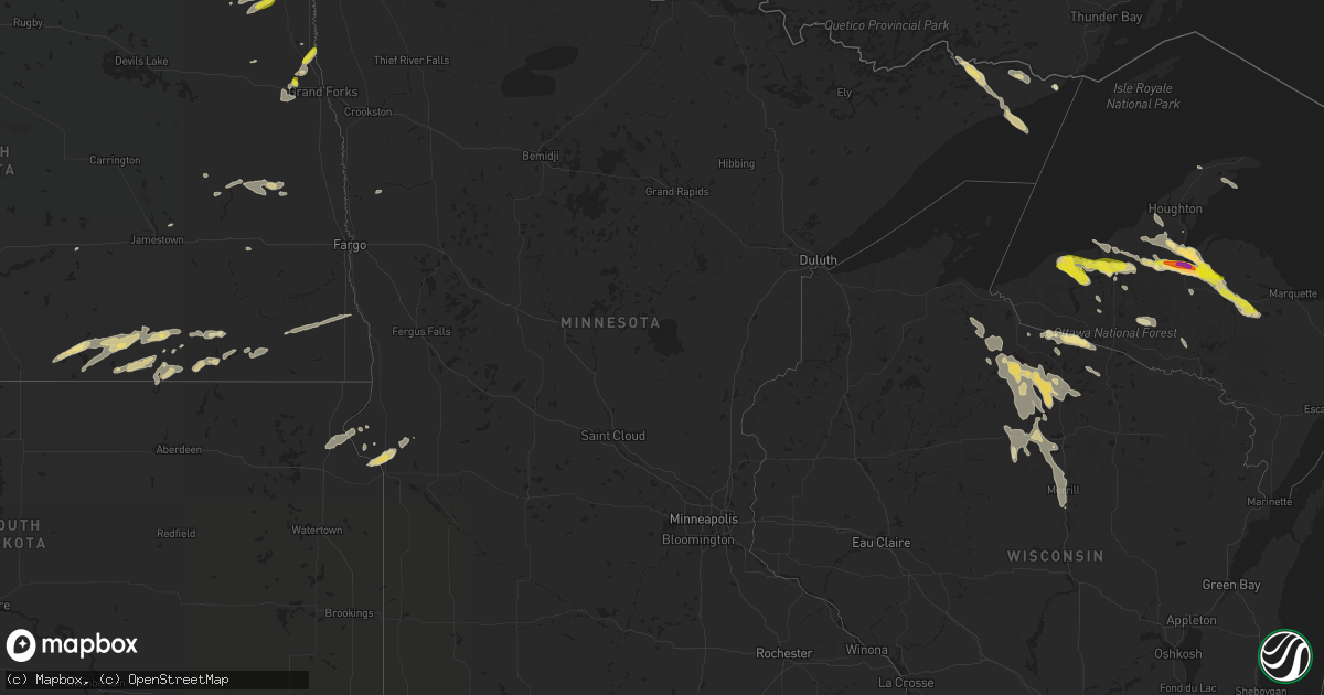
Hail Map in Minnesota on July 18, 2022
Get this storm
July 18 map
$229
one time, instant access
Download today. No call, no setup
Keep the $229
Bought the map and want the full workflow? Apply the entire $229 to a subscription within 7 days. None of it is wasted.
Every map, not just this one
This buys you this map. Subscription and you get every map we run, in the markets you choose from a few cities to whole states to nationwide. Plus real-time alerts the moment a storm fires.
Contact data
Name, contact info, occupancy, even credit band for addresses in the footprint. You go from where it hit to who to call.
Become the source they trust
Unlimited branding weather history reports on demand. You already have the documented answer ready for the property owner, and you are the one who showed up with it.
Property data and RoofTrace estimates
Pull up any address you have got, its value and the exact code rules for that jurisdiction, straight from One Click Code. Then RoofTrace estimates the squares, pitch, and roof value, priced the way you price.
Storm reports in Minnesota
Minnesota
| Date | Description |
|---|---|
| 07/18/20221:49 PM CDT | Trees down on long lake on lake vermilion. Delayed report. Time estimated from radar. |
| 07/18/20222:40 AM CDT | A local report indicates 1.00 inch wind near 3 N ROSEAU |
| 07/18/20222:15 AM CDT | Wind and hail impacted portions of eastern cannon township... Over a mix of farmland and wildlife management area. Time estimated based on radar. |
| 07/18/20221:12 AM CDT | At 611 AM CDT, severe thunderstorms were located along a line extending from 9 miles northeast of Long Point to Arnesen to near Swift, moving southeast at 35 mph. HAZARD...60 mph wind gusts and quarter size hail. SOURCE...Radar indicated. IMPACT...Hail damage to vehicles is expected. Expect wind damage to roofs, siding, and trees. Severe thunderstorms will be near... Birch Beach, Lude and Long Point around 620 AM CDT. Williams around 630 AM CDT.Other locations in the path of these severe thunderstorms includeWheelers Point, Graceton, Pitt and Baudette. |
| 07/18/202212:32 AM CDT | At 532 AM CDT, a severe thunderstorm was located near Pinecreek, or 9 miles northwest of Roseau, moving southeast at 45 mph. HAZARD...Quarter size hail. SOURCE...Radar indicated. IMPACT...Damage to vehicles is expected. This severe thunderstorm will be near... Roseau around 545 AM CDT.Other locations in the path of this severe thunderstorm includeSalol. |
All States Impacted by Hail Map on July 18, 2022
Cities Impacted by Hail Map on July 18, 2022
- Walhalla, ND
- Hays, MT
- Palermo, ND
- Stanley, ND
- Ross, ND
- Forbes, ND
- Ashley, ND
- Ellendale, ND
- Walkersville, MD
- Frederick, MD
- Ranson, WV
- Charles Town, WV
- Bunker Hill, WV
- Summit Point, WV
- Inwood, WV
- Kearneysville, WV
- Clear Brook, VA
- Newberry Springs, CA
- Peach Bottom, PA
- Nottingham, PA
- Clinton, MN
- Corona, SD
- Big Stone City, SD
- Ortonville, MN
- Oakes, ND
- Portal, ND
- Brockton, MT
- Poplar, MT
- Souris, ND
- Grand Marais, MN
- Flaxton, ND
- Kenmare, ND
- Bowbells, ND
- Minto, ND
- Middletown, MD
- Jefferson, MD
- Dunseith, ND
- Valier, MT
- Conrad, MT
- Mass City, MI
- Ewen, MI
- Rockland, MI
- White Pine, MI
- Ontonagon, MI
- Hickory Ridge, AR
- Harlem, MT
- Wildrose, ND
- Hoople, ND
- Crystal, ND
- Edinburg, ND
- Grand Portage, MN
- Trout Creek, MI
- Iron River, MI
- Peever, SD
- Veblen, SD
- Shepherdstown, WV
- Sharpsburg, MD
- Powers Lake, ND
- Columbus, ND
- Dazey, ND
- Luverne, ND
- Dumont, MN
- Butternut, WI
- Chassell, MI
- Mechanicsville, MD
- Noonan, ND
- Lancaster, MN
- Beardsley, MN
- Centreville, MD
- Max, NE
- Tappen, ND
- Minot, ND
- Glenburn, ND
- Stratton, NE
- Badger, MN
- Greenbush, MN
- Roseau, MN
- Saint Thomas, ND
- Drayton, ND
- Hinsdale, MT
- Larslan, MT
- Opheim, MT
- Richland, MT
- Peerless, MT
- Glentana, MT
- Marianna, AR
- Spiritwood, ND
- Bottineau, ND
- Burlington, ND
- Des Lacs, ND
- Surrey, ND
- Boulder Junction, WI
- Manitowish Waters, WI
- Fullerton, ND
- Bruce Crossing, MI
- Iron Belt, WI
- Shelby, MT
- Shenandoah Junction, WV
- Mohawk, MI
- Oxford, PA
- Cogswell, ND
- Forman, ND
- Leroy, AL
- Wagarville, AL
- Wales, ND
- Malta, MT
- Cut Bank, MT
- Ledger, MT
- Donnybrook, ND
- Kramer, ND
- Ray, ND
- Grenora, ND
- Homestead, MT
- Carpio, ND
- Upham, ND
- Williston, ND
- Dagmar, MT
- Zahl, ND
- Alamo, ND
- Mohall, ND
- Tioga, ND
- Medicine Lake, MT
- Mcgregor, ND
- Froid, MT
- Lansford, ND
- Epping, ND
- Crosby, ND
- Maxbass, ND
- Bainville, MT
- White Earth, ND
- Newburg, ND
- Hannah, ND
- Rocklake, ND
- Hope, ND
- Page, ND
- Galesburg, ND
- Big Sandy, MT
- Lloyd, MT
- Berthold, ND
- Leola, SD
- Zortman, MT
- Antelope, MT
- Crystal Falls, MI
- Arvilla, ND
- Emerado, ND
- Frederick, SD
- Cavalier, ND
- Scobey, MT
- Wolf Point, MT
- Flaxville, MT
- Bronx, NY
- Pelham, NY
- New Rochelle, NY
- Mercer, WI
- Lake Tomahawk, WI
- Lac Du Flambeau, WI
- Minocqua, WI
- Saint Germain, WI
- Woodruff, WI
- Phillips, WI
- Tripoli, WI
- Park Falls, WI
- Hazelhurst, WI
- Baltimore, MD
- Nottingham, MD
- Rosedale, MD
- Lamar, CO
- Wiley, CO
- Tucson, AZ
- Mill Neck, NY
- Glen Cove, NY
- Bayville, NY
- Huntington, NY
- Oyster Bay, NY
- Locust Valley, NY
- Plaza, ND
- Circle, MT
- Vida, MT
- Tunica, MS
- Harpers Ferry, WV
- Cliffside Park, NJ
- Leonia, NJ
- Edgewater, NJ
- Ridgefield, NJ
- Fort Lee, NJ
- Palisades Park, NJ
- Milnor, ND
- Langdon, ND
- Calvin, ND
- Whitetail, MT
- Park River, ND
- Halma, MN
- Lake Bronson, MN
- Hannaford, ND
- Greenville, SC
- Piedmont, SC
- Easley, SC
- Chokio, MN
- Grand Forks Afb, ND
- Mekinock, ND
- Sisseton, SD
- Arlington, AL
- Queenstown, MD
- Trinidad, CO
- Colfax, ND
- Barney, ND
- Wyndmere, ND
- Wahpeton, ND
- West Point, MS
- Starkville, MS
- Ogema, WI
- Oriska, ND
- Pageland, SC
- Jefferson, SC
- Oakland, MS
- Como, MS
- Tomahawk, WI
- Fulton, MS
- Crossville, AL
- Georgiana, AL
- Greenville, AL
- Wishek, ND
- Lanse, MI
- Antler, ND
- Conover, WI
- Eagle River, WI
- Inkster, ND
- Saltillo, MS
- Mooreville, MS
- Mantachie, MS
- Tupelo, MS
- Eureka, SD
- Herreid, SD
- McCrory, AR
- Benkelman, NE
- Hamilton, AL
- Tremont, MS
- Hackleburg, AL
- Hodges, AL
- Vina, AL
- Aberdeen, MS
- Okolona, MS
- Pelkie, MI
- Fredonia, ND
- Kulm, ND
- Berlin, ND
- Lehr, ND
- Edgeley, ND
- Daggett, CA
- Yermo, CA
- Belden, MS
- Presque Isle, WI
- Marks, MS
- Lambert, MS
- Charleston, MS
- Enid, MS
- Batesville, MS
- Saco, MT
- Whitewater, MT
- Reserve, MT
- Manvel, ND
- Oslo, MN
- Atlantic Mine, MI
- Painesdale, MI
- Irma, WI
- Rib Lake, WI
- Merrill, WI
- Brantwood, WI
- Prentice, WI
- Lake Linden, MI
- Guntown, MS
- Nisula, MI
- Baraga, MI
- Ishpeming, MI
- Toivola, MI
- Michigamme, MI
- Champion, MI
- Republic, MI
- Crenshaw, MS
- Pope, MS
- Sledge, MS
- Tutwiler, MS
- Sardis, MS
- Patagonia, AZ
- Nogales, AZ
- Marenisco, MI
- Land O'Lakes, WI
- Jackson, AL
- Senatobia, MS
- Browns Valley, MN
- Borup, MN
- Ada, MN
- Mellen, WI
- Upson, WI
- Wakefield, MI
- Watersmeet, MI
- Covington, MI
- Lamoure, ND
- Verona, ND
- Lovettsville, VA
- Coffeeville, MS
- Water Valley, MS
- Pinetop, AZ
- Columbus, MS
- Purcellville, VA
- Middleburg, VA
- Leesburg, VA
- Thomaston, AL
- Ambrose, ND
- Fortuna, ND
- Bergland, MI
- Glidden, WI
- Glenwood, MN
- Richey, MT
- Dupree, SD
- Saint John, ND
- Grafton, ND
- Sunburst, MT
- Kevin, MT
- Oilmont, MT
- Galata, MT
- Vergennes, VT
- Karlstad, MN
- Nashua, MT
- Frazer, MT
- Vandalia, MT
- Fort Peck, MT
- Glasgow, MT
- Redstone, MT
- Lignite, ND
- Sherwood, ND
- Tolley, ND
- Perth, ND
- Hansboro, ND
- Maida, ND
- Bisbee, ND
- Belcourt, ND
- Mylo, ND
- Sarles, ND
- Munich, ND
- Rolla, ND
- Egeland, ND


