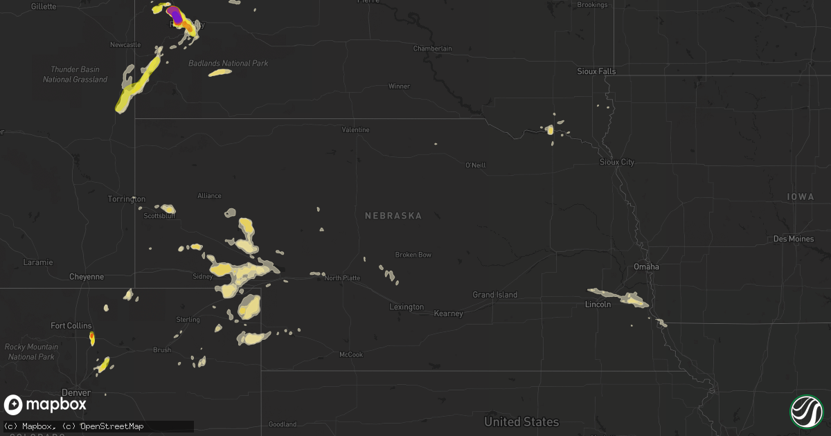
Hail Map in Nebraska on July 18, 2016
Get this storm
July 18 map
$229
one time, instant access
Download today. No call, no setup
Keep the $229
Bought the map and want the full workflow? Apply the entire $229 to a subscription within 7 days. None of it is wasted.
Every map, not just this one
This buys you this map. Subscription and you get every map we run, in the markets you choose from a few cities to whole states to nationwide. Plus real-time alerts the moment a storm fires.
Contact data
Name, contact info, occupancy, even credit band for addresses in the footprint. You go from where it hit to who to call.
Become the source they trust
Unlimited branding weather history reports on demand. You already have the documented answer ready for the property owner, and you are the one who showed up with it.
Property data and RoofTrace estimates
Pull up any address you have got, its value and the exact code rules for that jurisdiction, straight from One Click Code. Then RoofTrace estimates the squares, pitch, and roof value, priced the way you price.
Storm reports in Nebraska
Nebraska
| Date | Description |
|---|---|
| 07/18/20161:32 AM CDT | Small branches down. Personal wind sensor on top of a grain elevator suggested 60+ mph but cannot confirm winds this strong closer to surface. |
| 07/18/201612:14 AM CDT | Home weather station reported wind gust to 72 mph. Wind blew several tree branches down. |
| 07/17/20169:00 PM CDT | Eight power poles downed. Tin peeled off of an out building. Windmill damaged. Dime to nickel size hail reported. |
All States Impacted by Hail Map on July 18, 2016
Cities Impacted by Hail Map on July 18, 2016
- Macedon, NY
- Fairport, NY
- Walworth, NY
- Weld, ME
- Temple, ME
- Dade City, FL
- Enders, NE
- Wauneta, NE
- Lewellen, NE
- Big Springs, NE
- Brule, NE
- Hammond, NY
- Heuvelton, NY
- Ogdensburg, NY
- Paxton, NE
- Sutherland, NE
- Dudley, GA
- Dublin, GA
- Dexter, GA
- Corinna, ME
- Exeter, ME
- Zephyrhills, FL
- Storm Lake, IA
- Alta, IA
- Beresford, SD
- Cut Bank, MT
- Saint Regis Falls, NY
- Alvo, NE
- Murdock, NE
- Elmwood, NE
- Houston, TX
- Orange, VA
- Petersburg, IL
- Greenview, IL
- Raymond, NE
- Geyser, MT
- Denton, MT
- Coffee Creek, MT
- Stanford, MT
- Manville, WY
- Greeley, CO
- Madison, ME
- Norridgewock, ME
- New Vineyard, ME
- Farmington, ME
- Phillips, ME
- Strong, ME
- Anson, ME
- Saint Johnsbury, VT
- Littleton, NH
- Clyde, NY
- Savannah, NY
- Steinhatchee, FL
- Fort Peck, MT
- Rapid City, SD
- Aurelia, IA
- Holyoke, CO
- Wray, CO
- Custer, SD
- Sedalia, CO
- Castle Rock, CO
- Ivesdale, IL
- Caratunk, ME
- Imperial, NE
- Framingham, MA
- Ashland, MA
- Sherborn, MA
- Natick, MA
- Webster, FL
- Grover, CO
- Vermontville, NY
- Gillette, WY
- Upton, WY
- Oshkosh, NE
- Monarch, MT
- Neihart, MT
- Hilger, MT
- Cascade, MT
- White Sulphur Springs, MT
- Winifred, MT
- Lewistown, MT
- Raynesford, MT
- Stockett, MT
- Great Falls, MT
- Belt, MT
- Hopkinton, MA
- Au Sable Forks, NY
- Bloomingdale, NY
- Saranac Lake, NY
- Paul Smiths, NY
- Ashwood, OR
- Aguilar, CO
- Whitefish, MT
- Wasta, SD
- Julesburg, CO
- Amherst, CO
- Lodgepole, NE
- Otis, CO
- Cook, NE
- Keystone, SD
- Hermosa, SD
- Zortman, MT
- Chappell, NE
- Corinth, VT
- East Corinth, VT
- Bradford, VT
- Piermont, NH
- Browning, MT
- Colebrook, NH
- Errol, NH
- Lincoln, NE
- Danville, PA
- Muncy, PA
- Watsontown, PA
- Turbotville, PA
- Jersey Shore, PA
- Montgomery, PA
- Williamsport, PA
- Allenwood, PA
- New Columbia, PA
- Oldtown, MD
- Cumberland, MD
- Sundance, WY
- Hinsdale, MT
- Montgomery Center, VT
- Martville, NY
- Sterling, NY
- Hannibal, NY
- Wolcott, NY
- Red Creek, NY
- Champion, NE
- Paoli, CO
- Haxtun, CO
- Bartow, GA
- Lisbon, NH
- Bath, NH
- Saint Albans, ME
- Prineville, OR
- Powell Butte, OR
- Newport, ME
- Stetson, ME
- Carmel, ME
- Bangor, ME
- Palmyra, ME
- Plymouth, ME
- Etna, ME
- Callaway, NE
- Keenesburg, CO
- Hudson, CO
- Horseshoe Beach, FL
- Weeping Water, NE
- Avoca, NE
- Nehawka, NE
- Evans, CO
- La Salle, CO
- Bingham, ME
- Pittsburg, NH
- North Anson, ME
- Levant, ME
- Skowhegan, ME
- Athens, ME
- Harmony, ME
- Milford, ME
- New Portland, ME
- Hudson, ME
- Solon, ME
- Hartland, ME
- Kenduskeag, ME
- Dexter, ME
- Greenbush, ME
- Beecher Falls, VT
- Norton, VT
- Orono, ME
- Bradley, ME
- Canaan, VT
- Andover, ME
- Rangeley, ME
- Corinth, ME
- Old Town, ME
- Kingfield, ME
- Edgemont, SD
- Lusk, WY
- Lance Creek, WY
- Edgefield, SC
- Johnston, SC
- Rye, CO
- Beulah, CO
- Trego, MT
- Brighton, CO
- Smithfield, ME
- Waterville, ME
- Oakland, ME
- Fairfield, ME
- Crofton, NE
- Yankton, SD
- Saint Helena, NE
- Island Pond, VT
- New Sharon, ME
- Guildhall, VT
- Lake Lure, NC
- Sac City, IA
- Lake View, IA
- Malta, MT
- Ault, CO
- Sidney, NE
- Gurley, NE
- Canaan, ME
- Pittsfield, ME
- Pine Ridge, SD
- Heathsville, VA
- Reedville, VA
- Newberry, SC
- Mount Pulaski, IL
- Lincoln, IL
- Minatare, NE
- Scottsbluff, NE
- Worton, MD
- Wrightsville, GA
- Nemo, SD
- Barnet, VT
- Astoria, IL
- Havana, IL
- Summerville, OR
- Elgin, OR
- Vienna, GA
- Byromville, GA
- Cantonment, FL
- Enosburg Falls, VT
- Richford, VT
- East Berkshire, VT
- Ashton, IA
- Spartanburg, SC
- Alton, IA
- Remsen, IA
- Tabor, SD
- Yoder, WY
- Camden Wyoming, DE
- Viola, DE
- Fairmount, IL
- Indianola, IL
- Sioux Center, IA
- Hawarden, IA
- Columbia, SC
- Middleport, NY
- Basom, NY
- Medina, NY
- Parishville, NY
- Mill Spring, NC
- Bayard, NE
- Piedmont, SD
- Sturgis, SD
- Black Hawk, SD
- Rembert, SC
- Carlton, GA
- Wadley, GA
- Ruckersville, VA
- Heart Butte, MT
- Bridgeport, IL
- Lawrenceville, IL
- Saint Francisville, IL
- Golconda, IL
- Garfield, GA
- Montoursville, PA
- West Topsham, VT
- Fairlee, VT
- Washington, VT
- Orford, NH
- Loganville, GA
- Dacula, GA
- Grayson, GA
- Lawrenceville, GA
- Quimby, IA
- Anderson, SC
- Iva, SC
- Bennett, CO
- Commerce, GA
- Ellsworth, NE
- Statesboro, GA
- Sumner, IL
- Deadwood, SD
- Mission Hill, SD
- Utica, SD
- Moorcroft, WY
- Argenta, IL
- Cisco, IL
- Sedgwick, CO
- Crook, CO
- Altavista, VA
- Lynch Station, VA
- Ontario, NY
- Hershey, NE
- Williamstown, VT
- Graniteville, VT
- Wentworth, NH
- Topsham, VT
- Barre, VT
- Perryville, MO
- Fort Benton, MT
- Primghar, IA
- Hartley, IA
- North Troy, VT
- Malone, NY
- Cleghorn, IA
- Bethlehem, NH
- Monroe, NH
- Saluda, SC
- Lead, SD
- Warwick, MD
- Earleville, MD
- Marcus, IA
- Caputa, SD
- Hughesville, PA
- Kenney, IL
- Jordan, MT
- Brewer, ME
- Lisco, NE
- Plattsburgh, NY
- Peru, NY
- Lewistown, IL
- Topeka, IL
- Easton, IL
- Phoenix, AZ
- Newark, DE
- Brussels, IL
- Batchtown, IL
- Nebraska City, NE
- Eddington, ME
- North Henderson, IL
- Ellisville, IL
- Avon, IL
- London Mills, IL
- Canton, IL
- Bartow, FL
- Atlanta, IL
- Lakeland, FL
- Clinton, IL
- Waynesville, IL
- Red Bud, IL
- Evansville, IL
- Broadus, MT
- Dalton, NE
- Le Mars, IA
- Arcola, IL
- Humboldt, IL
- Gayville, SD
- Bridgeport, NE
- Wheatland, WY
- Allentown, PA
- Whitehall, PA
- Newcastle, WY
- Kershaw, SC
- Bethune, SC
- Waverly, NE
- Homer, NY
- Cortland, NY
- Locke, NY
- Buchanan, GA
- Galva, IA
- Early, IA
- Schaller, IA
- Beattyville, KY
- Stanardsville, VA
- Trenton, SC
- Glendo, WY
- Old Fort, NC
- Fleming, CO
- Newport, VT
- Newport Center, VT
- Mullen, NE
- Hurt, VA
- Morrill, NE
- Aiken, SC
- Groveland, FL
- Tallapoosa, GA
- Akron, CO
- Monticello, IL
- Roxbury, ME
- Dover, DE
- Felton, DE
- Magnolia, DE
- Gothenburg, NE
- Auburndale, FL
- Winter Haven, FL
- Logan, OH
- Ogallala, NE
- Troy, MT
- Bridgeport, CT
- Stratford, CT
- Lake Placid, NY
- Chesapeake City, MD
- Middletown, DE
- Windsor, SC
- Wilmington, NY
- Rainbow Lake, NY
- Rock Valley, IA
- Doon, IA
- Pesotum, IL
- Sadorus, IL
- Dyke, VA
- Harrisburg, NE
- Terryville, CT
- Danville, VT
- Ovid, CO
- Nags Head, NC
- La Grande, OR
- Penfield, NY
- Cozad, NE
- Somerset, VA
- Mason City, IL
- Bloomsdale, MO
- Hopkins, SC
- Springfield, IL
- Tryon, NE
- Chestertown, MD
- Volin, SD
- West Columbia, SC
- Lemoyne, NE
- Dieterich, IL
- Wheeler, IL
- Moravia, NY
- Oakfield, NY
- Akron, NY
- Fairview, IL
- Brazil, IN
- Teutopolis, IL
- Montrose, IL
- Roggen, CO
- Chambers, AZ
- East Dublin, GA
- Mitchell, NE
- Antelope, OR
- Sullivan, IL
- Lovington, IL
- Linden, PA
- Hindsboro, IL
- Oakland, IL
- Punta Gorda, FL
- Sugar Hill, NH
- Franconia, NH
- Martinsville, IN
- Derby Line, VT
- Rock Port, MO
- Westboro, MO
- Tarkio, MO
- Colton, NY
- Hull, IA
- Stratton, ME
- Greenwood, NE
- Otoe, NE
- Davey, NE
- Murray, NE
- Manley, NE
- Union, NE
- Louisville, NE
- Zolfo Springs, FL
- Graniteville, SC
- Valier, MT
- Camargo, IL
- Villa Grove, IL
- Tuscola, IL
- Atwood, IL
- Hudson, SD
- Sorrento, FL
- Sidney, IL
- Tolono, IL
- Philo, IL
- Guilford, ME
- Groton, NY
- Scipio Center, NY
- Genoa, NY
- Brady, NE
- Arnold, NE
- Limestone, ME
- Coin, IA
- Shenandoah, IA
- Green Spring, WV
- San Jose, IL
- Saint David, IL
- Cuba, IL
- Burgess, VA
- North Port, FL
- Nashua, MT
- Bude, MS
- Gerlaw, IL
- Quincy, IN
- Monrovia, IN
- Paragon, IN
- Coatesville, IN
- Clayton, IN
- Mooresville, IN
- Fillmore, IN
- Greencastle, IN
- Brooklyn, IN
- Morgantown, IN
- Stilesville, IN
- Carbon, IN
- Mapleton, ME
- Thurman, IA
- Sidney, IA
- Smithfield, IL
- Newton, IL
- Arthur, NE
- Merino, CO
- Hiawassee, GA
- Box Elder, SD
- Wall, SD
- Millen, GA
- Torrington, WY
- New Port Richey, FL
- Franklin, NC
- Saybrook, IL
- Hartsville, SC
- Millville, NJ
- Kingsley, IA
- Port Byron, NY
- Sangerville, ME
- Abbot, ME
- Andreas, PA
- Newport, NE
- Cheshire, MA
- Foley, MO
- Winfield, MO
- Watson, IL
- Effingham, IL
- Bronson, IA
- Satsuma, FL
- Sutherland, IA
- Wolf Point, MT
- Milton, FL
- Hamburg, IA
- Clermont, FL
- Winter Garden, FL
- Fairfield, CT
- Sherman, IL
- Williamsville, IL
- Lakeside, NE
- Biddle, MT
- Boyes, MT
- Cato, NY
- Pennellville, NY
- Moran, MI
- Saint Ignace, MI
- Mackinac Island, MI
- Pointe Aux Pins, MI
- Morgan, VT
- Whitefield, NH
- Clinton, MT
- Florence, MT
- Missoula, MT


