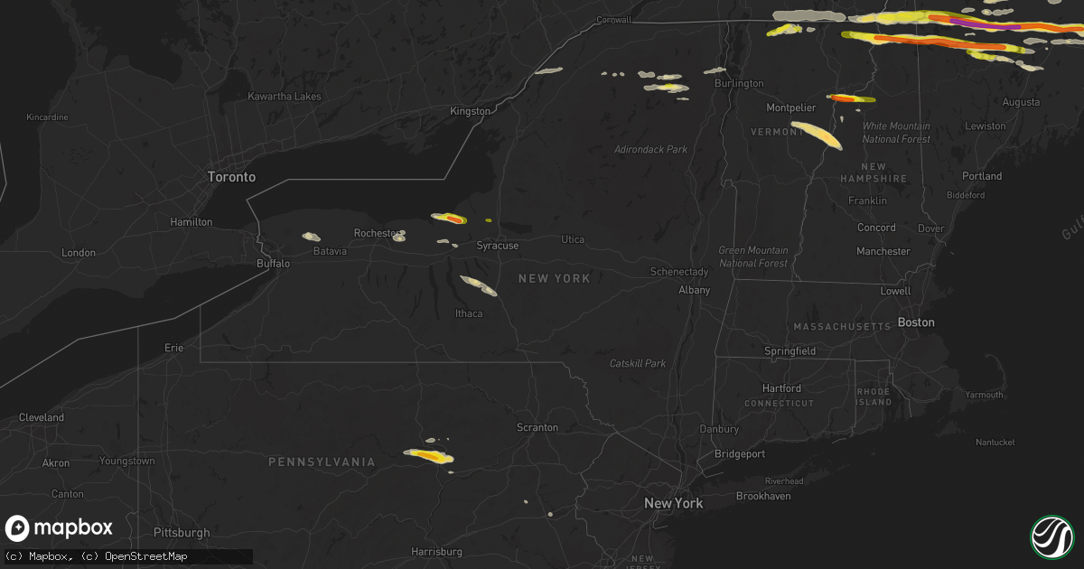
Hail Map in New York on July 18, 2016
Get this storm
July 18 map
$229
one time, instant access
Download today. No call, no setup
Keep the $229
Bought the map and want the full workflow? Apply the entire $229 to a subscription within 7 days. None of it is wasted.
Every map, not just this one
This buys you this map. Subscription and you get every map we run, in the markets you choose from a few cities to whole states to nationwide. Plus real-time alerts the moment a storm fires.
Contact data
Name, contact info, occupancy, even credit band for addresses in the footprint. You go from where it hit to who to call.
Become the source they trust
Unlimited branding weather history reports on demand. You already have the documented answer ready for the property owner, and you are the one who showed up with it.
Property data and RoofTrace estimates
Pull up any address you have got, its value and the exact code rules for that jurisdiction, straight from One Click Code. Then RoofTrace estimates the squares, pitch, and roof value, priced the way you price.
Storm reports in New York
New York
| Date | Description |
|---|---|
| 07/18/20165:04 PM CDT | Marine thunderstorm wind gust of 50 knots |
| 07/18/20164:40 PM CDT | Marine thunderstorm wind gust of 50 knots |
| 07/18/20164:22 PM CDT | Tree down at north jerusalem road and putnam avenue |
| 07/18/20164:20 PM CDT | Damage to barn and house roofs... Telephone pole snapped and landed on truck |
| 07/18/20164:10 PM CDT | Tree down on van. Nobody hurt. Relayed by cnycentral |
| 07/18/20164:04 PM CDT | Tree down on 47th street |
| 07/18/20163:48 PM CDT | Marine thunderstorm wind of 59 knots |
| 07/18/20163:45 PM CDT | Trees down at 2 locations in moravia |
| 07/18/20162:50 PM CDT | Trees down on wires at intersection of wood street and goldfinch lane |
| 07/18/20161:30 PM CDT | A local report indicates 1.25 inch wind near VERMONTVILLE |
| 07/18/201612:50 PM CDT | Five tree limbs of six inches in diameter snapped off. One large limb blocking rte 14 south. |
| 07/18/201612:46 PM CDT | Pole down across road |
| 07/18/201612:25 PM CDT | Several trees downed... Trees also down in cleveland |
| 07/18/201612:25 PM CDT | Tree brought down wires. Roadway blocked |
| 07/18/201612:25 PM CDT | Trees and wires down at 517 county rte 49. |
| 07/18/201612:22 PM CDT | Downed power lines on route 43. |
| 07/18/201612:20 PM CDT | Powerlines down 1/2 mile west of route 4 on route 32. |
| 07/18/201612:17 PM CDT | Trees and wires down at 50 mountain rd... Harrison ave... And 30 reservoir rd. |
| 07/18/201612:15 PM CDT | Powerlines and large tree limbs down on richards st near cedar dam. |
| 07/18/201611:53 AM CDT | Nickel and quarter sized hail |
| 07/18/201611:51 AM CDT | Tree down on rt 22 |
| 07/18/201611:36 AM CDT | Tree down at intersection of route 402 and route 405. |
| 07/18/201611:35 AM CDT | A local report indicates 1.00 inch wind near HANNIBAL |
| 07/18/201611:24 AM CDT | Wires down. |
| 07/18/201611:21 AM CDT | Trees down across road |
| 07/18/201611:15 AM CDT | Tree blown down. |
| 07/18/201610:39 AM CDT | Tree down on us rt 11 |
| 07/18/201610:32 AM CDT | Tree down on morgan rd |
| 07/18/201610:23 AM CDT | Trees down on wires |
All States Impacted by Hail Map on July 18, 2016
Cities Impacted by Hail Map on July 18, 2016
- Macedon, NY
- Fairport, NY
- Walworth, NY
- Weld, ME
- Temple, ME
- Dade City, FL
- Enders, NE
- Wauneta, NE
- Lewellen, NE
- Big Springs, NE
- Brule, NE
- Hammond, NY
- Heuvelton, NY
- Ogdensburg, NY
- Paxton, NE
- Sutherland, NE
- Dudley, GA
- Dublin, GA
- Dexter, GA
- Corinna, ME
- Exeter, ME
- Zephyrhills, FL
- Storm Lake, IA
- Alta, IA
- Beresford, SD
- Cut Bank, MT
- Saint Regis Falls, NY
- Alvo, NE
- Murdock, NE
- Elmwood, NE
- Houston, TX
- Orange, VA
- Petersburg, IL
- Greenview, IL
- Raymond, NE
- Geyser, MT
- Denton, MT
- Coffee Creek, MT
- Stanford, MT
- Manville, WY
- Greeley, CO
- Madison, ME
- Norridgewock, ME
- New Vineyard, ME
- Farmington, ME
- Phillips, ME
- Strong, ME
- Anson, ME
- Saint Johnsbury, VT
- Littleton, NH
- Clyde, NY
- Savannah, NY
- Steinhatchee, FL
- Fort Peck, MT
- Rapid City, SD
- Aurelia, IA
- Holyoke, CO
- Wray, CO
- Custer, SD
- Sedalia, CO
- Castle Rock, CO
- Ivesdale, IL
- Caratunk, ME
- Imperial, NE
- Framingham, MA
- Ashland, MA
- Sherborn, MA
- Natick, MA
- Webster, FL
- Grover, CO
- Vermontville, NY
- Gillette, WY
- Upton, WY
- Oshkosh, NE
- Monarch, MT
- Neihart, MT
- Hilger, MT
- Cascade, MT
- White Sulphur Springs, MT
- Winifred, MT
- Lewistown, MT
- Raynesford, MT
- Stockett, MT
- Great Falls, MT
- Belt, MT
- Hopkinton, MA
- Au Sable Forks, NY
- Bloomingdale, NY
- Saranac Lake, NY
- Paul Smiths, NY
- Ashwood, OR
- Aguilar, CO
- Whitefish, MT
- Wasta, SD
- Julesburg, CO
- Amherst, CO
- Lodgepole, NE
- Otis, CO
- Cook, NE
- Keystone, SD
- Hermosa, SD
- Zortman, MT
- Chappell, NE
- Corinth, VT
- East Corinth, VT
- Bradford, VT
- Piermont, NH
- Browning, MT
- Colebrook, NH
- Errol, NH
- Lincoln, NE
- Danville, PA
- Muncy, PA
- Watsontown, PA
- Turbotville, PA
- Jersey Shore, PA
- Montgomery, PA
- Williamsport, PA
- Allenwood, PA
- New Columbia, PA
- Oldtown, MD
- Cumberland, MD
- Sundance, WY
- Hinsdale, MT
- Montgomery Center, VT
- Martville, NY
- Sterling, NY
- Hannibal, NY
- Wolcott, NY
- Red Creek, NY
- Champion, NE
- Paoli, CO
- Haxtun, CO
- Bartow, GA
- Lisbon, NH
- Bath, NH
- Saint Albans, ME
- Prineville, OR
- Powell Butte, OR
- Newport, ME
- Stetson, ME
- Carmel, ME
- Bangor, ME
- Palmyra, ME
- Plymouth, ME
- Etna, ME
- Callaway, NE
- Keenesburg, CO
- Hudson, CO
- Horseshoe Beach, FL
- Weeping Water, NE
- Avoca, NE
- Nehawka, NE
- Evans, CO
- La Salle, CO
- Bingham, ME
- Pittsburg, NH
- North Anson, ME
- Levant, ME
- Skowhegan, ME
- Athens, ME
- Harmony, ME
- Milford, ME
- New Portland, ME
- Hudson, ME
- Solon, ME
- Hartland, ME
- Kenduskeag, ME
- Dexter, ME
- Greenbush, ME
- Beecher Falls, VT
- Norton, VT
- Orono, ME
- Bradley, ME
- Canaan, VT
- Andover, ME
- Rangeley, ME
- Corinth, ME
- Old Town, ME
- Kingfield, ME
- Edgemont, SD
- Lusk, WY
- Lance Creek, WY
- Edgefield, SC
- Johnston, SC
- Rye, CO
- Beulah, CO
- Trego, MT
- Brighton, CO
- Smithfield, ME
- Waterville, ME
- Oakland, ME
- Fairfield, ME
- Crofton, NE
- Yankton, SD
- Saint Helena, NE
- Island Pond, VT
- New Sharon, ME
- Guildhall, VT
- Lake Lure, NC
- Sac City, IA
- Lake View, IA
- Malta, MT
- Ault, CO
- Sidney, NE
- Gurley, NE
- Canaan, ME
- Pittsfield, ME
- Pine Ridge, SD
- Heathsville, VA
- Reedville, VA
- Newberry, SC
- Mount Pulaski, IL
- Lincoln, IL
- Minatare, NE
- Scottsbluff, NE
- Worton, MD
- Wrightsville, GA
- Nemo, SD
- Barnet, VT
- Astoria, IL
- Havana, IL
- Summerville, OR
- Elgin, OR
- Vienna, GA
- Byromville, GA
- Cantonment, FL
- Enosburg Falls, VT
- Richford, VT
- East Berkshire, VT
- Ashton, IA
- Spartanburg, SC
- Alton, IA
- Remsen, IA
- Tabor, SD
- Yoder, WY
- Camden Wyoming, DE
- Viola, DE
- Fairmount, IL
- Indianola, IL
- Sioux Center, IA
- Hawarden, IA
- Columbia, SC
- Middleport, NY
- Basom, NY
- Medina, NY
- Parishville, NY
- Mill Spring, NC
- Bayard, NE
- Piedmont, SD
- Sturgis, SD
- Black Hawk, SD
- Rembert, SC
- Carlton, GA
- Wadley, GA
- Ruckersville, VA
- Heart Butte, MT
- Bridgeport, IL
- Lawrenceville, IL
- Saint Francisville, IL
- Golconda, IL
- Garfield, GA
- Montoursville, PA
- West Topsham, VT
- Fairlee, VT
- Washington, VT
- Orford, NH
- Loganville, GA
- Dacula, GA
- Grayson, GA
- Lawrenceville, GA
- Quimby, IA
- Anderson, SC
- Iva, SC
- Bennett, CO
- Commerce, GA
- Ellsworth, NE
- Statesboro, GA
- Sumner, IL
- Deadwood, SD
- Mission Hill, SD
- Utica, SD
- Moorcroft, WY
- Argenta, IL
- Cisco, IL
- Sedgwick, CO
- Crook, CO
- Altavista, VA
- Lynch Station, VA
- Ontario, NY
- Hershey, NE
- Williamstown, VT
- Graniteville, VT
- Wentworth, NH
- Topsham, VT
- Barre, VT
- Perryville, MO
- Fort Benton, MT
- Primghar, IA
- Hartley, IA
- North Troy, VT
- Malone, NY
- Cleghorn, IA
- Bethlehem, NH
- Monroe, NH
- Saluda, SC
- Lead, SD
- Warwick, MD
- Earleville, MD
- Marcus, IA
- Caputa, SD
- Hughesville, PA
- Kenney, IL
- Jordan, MT
- Brewer, ME
- Lisco, NE
- Plattsburgh, NY
- Peru, NY
- Lewistown, IL
- Topeka, IL
- Easton, IL
- Phoenix, AZ
- Newark, DE
- Brussels, IL
- Batchtown, IL
- Nebraska City, NE
- Eddington, ME
- North Henderson, IL
- Ellisville, IL
- Avon, IL
- London Mills, IL
- Canton, IL
- Bartow, FL
- Atlanta, IL
- Lakeland, FL
- Clinton, IL
- Waynesville, IL
- Red Bud, IL
- Evansville, IL
- Broadus, MT
- Dalton, NE
- Le Mars, IA
- Arcola, IL
- Humboldt, IL
- Gayville, SD
- Bridgeport, NE
- Wheatland, WY
- Allentown, PA
- Whitehall, PA
- Newcastle, WY
- Kershaw, SC
- Bethune, SC
- Waverly, NE
- Homer, NY
- Cortland, NY
- Locke, NY
- Buchanan, GA
- Galva, IA
- Early, IA
- Schaller, IA
- Beattyville, KY
- Stanardsville, VA
- Trenton, SC
- Glendo, WY
- Old Fort, NC
- Fleming, CO
- Newport, VT
- Newport Center, VT
- Mullen, NE
- Hurt, VA
- Morrill, NE
- Aiken, SC
- Groveland, FL
- Tallapoosa, GA
- Akron, CO
- Monticello, IL
- Roxbury, ME
- Dover, DE
- Felton, DE
- Magnolia, DE
- Gothenburg, NE
- Auburndale, FL
- Winter Haven, FL
- Logan, OH
- Ogallala, NE
- Troy, MT
- Bridgeport, CT
- Stratford, CT
- Lake Placid, NY
- Chesapeake City, MD
- Middletown, DE
- Windsor, SC
- Wilmington, NY
- Rainbow Lake, NY
- Rock Valley, IA
- Doon, IA
- Pesotum, IL
- Sadorus, IL
- Dyke, VA
- Harrisburg, NE
- Terryville, CT
- Danville, VT
- Ovid, CO
- Nags Head, NC
- La Grande, OR
- Penfield, NY
- Cozad, NE
- Somerset, VA
- Mason City, IL
- Bloomsdale, MO
- Hopkins, SC
- Springfield, IL
- Tryon, NE
- Chestertown, MD
- Volin, SD
- West Columbia, SC
- Lemoyne, NE
- Dieterich, IL
- Wheeler, IL
- Moravia, NY
- Oakfield, NY
- Akron, NY
- Fairview, IL
- Brazil, IN
- Teutopolis, IL
- Montrose, IL
- Roggen, CO
- Chambers, AZ
- East Dublin, GA
- Mitchell, NE
- Antelope, OR
- Sullivan, IL
- Lovington, IL
- Linden, PA
- Hindsboro, IL
- Oakland, IL
- Punta Gorda, FL
- Sugar Hill, NH
- Franconia, NH
- Martinsville, IN
- Derby Line, VT
- Rock Port, MO
- Westboro, MO
- Tarkio, MO
- Colton, NY
- Hull, IA
- Stratton, ME
- Greenwood, NE
- Otoe, NE
- Davey, NE
- Murray, NE
- Manley, NE
- Union, NE
- Louisville, NE
- Zolfo Springs, FL
- Graniteville, SC
- Valier, MT
- Camargo, IL
- Villa Grove, IL
- Tuscola, IL
- Atwood, IL
- Hudson, SD
- Sorrento, FL
- Sidney, IL
- Tolono, IL
- Philo, IL
- Guilford, ME
- Groton, NY
- Scipio Center, NY
- Genoa, NY
- Brady, NE
- Arnold, NE
- Limestone, ME
- Coin, IA
- Shenandoah, IA
- Green Spring, WV
- San Jose, IL
- Saint David, IL
- Cuba, IL
- Burgess, VA
- North Port, FL
- Nashua, MT
- Bude, MS
- Gerlaw, IL
- Quincy, IN
- Monrovia, IN
- Paragon, IN
- Coatesville, IN
- Clayton, IN
- Mooresville, IN
- Fillmore, IN
- Greencastle, IN
- Brooklyn, IN
- Morgantown, IN
- Stilesville, IN
- Carbon, IN
- Mapleton, ME
- Thurman, IA
- Sidney, IA
- Smithfield, IL
- Newton, IL
- Arthur, NE
- Merino, CO
- Hiawassee, GA
- Box Elder, SD
- Wall, SD
- Millen, GA
- Torrington, WY
- New Port Richey, FL
- Franklin, NC
- Saybrook, IL
- Hartsville, SC
- Millville, NJ
- Kingsley, IA
- Port Byron, NY
- Sangerville, ME
- Abbot, ME
- Andreas, PA
- Newport, NE
- Cheshire, MA
- Foley, MO
- Winfield, MO
- Watson, IL
- Effingham, IL
- Bronson, IA
- Satsuma, FL
- Sutherland, IA
- Wolf Point, MT
- Milton, FL
- Hamburg, IA
- Clermont, FL
- Winter Garden, FL
- Fairfield, CT
- Sherman, IL
- Williamsville, IL
- Lakeside, NE
- Biddle, MT
- Boyes, MT
- Cato, NY
- Pennellville, NY
- Moran, MI
- Saint Ignace, MI
- Mackinac Island, MI
- Pointe Aux Pins, MI
- Morgan, VT
- Whitefield, NH
- Clinton, MT
- Florence, MT
- Missoula, MT


