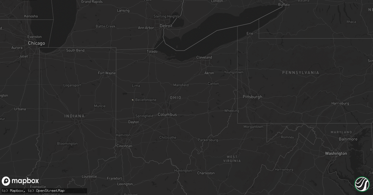
Hail Map in Ohio on July 17, 2024
Get this storm
July 17 map
$229
one time, instant access
Download today. No call, no setup
Keep the $229
Bought the map and want the full workflow? Apply the entire $229 to a subscription within 7 days. None of it is wasted.
Every map, not just this one
This buys you this map. Subscription and you get every map we run, in the markets you choose from a few cities to whole states to nationwide. Plus real-time alerts the moment a storm fires.
Contact data
Name, contact info, occupancy, even credit band for addresses in the footprint. You go from where it hit to who to call.
Become the source they trust
Unlimited branding weather history reports on demand. You already have the documented answer ready for the property owner, and you are the one who showed up with it.
Property data and RoofTrace estimates
Pull up any address you have got, its value and the exact code rules for that jurisdiction, straight from One Click Code. Then RoofTrace estimates the squares, pitch, and roof value, priced the way you price.
Storm reports in Ohio
Ohio
| Date | Description |
|---|---|
| 07/17/20243:50 PM CDT | Tree down on comly street. |
| 07/17/20243:30 PM CDT | 1 tree reported down. |
| 07/17/20243:29 PM CDT | Tree down on griggs road. |
| 07/17/20242:58 PM CDT | Report from mping: 3-inch tree limbs broken. |
| 07/17/20242:53 PM CDT | 8 inch tree down in worthington near arapaho avenue and arapaho court. Time estimated from radar. |
| 07/17/20241:43 PM CDT | Report from two media sources of public reports of trees down. Time estimated from radar. |
| 07/17/202412:43 PM CDT | Tree blocking road. Time estimated from radar. |
| 07/17/202412:42 PM CDT | Tree blocking road. Time estimated from radar. |
| 07/17/202412:38 PM CDT | Tree blocking road. Time estimated from radar. |
All States Impacted by Hail Map on July 17, 2024
Cities Impacted by Hail Map on July 17, 2024
- Royal, AR
- Hot Springs National Park, AR
- Fordland, MO
- Rogersville, MO
- Comins, MI
- Curran, MI
- Shuqualak, MS
- Gladwin, MI
- Tutwiler, MS
- Drew, MS
- Parchman, MS
- Aliceville, AL
- Anna, OH
- Minster, OH
- Lusk, WY
- Sidney, OH
- Jackson, LA
- Zachary, LA
- Pride, LA
- Columbia, MS
- Harrison, NE
- Denham Springs, LA
- Buffalo Gap, SD
- Hot Springs, SD
- Blairstown, NJ
- Slaughter, LA
- Greenwell Springs, LA
- Unadilla, GA
- Pinehurst, GA
- Marion, AL
- Franklin, KY
- Ladonia, TX
- Wolfe City, TX
- Jay Em, WY
- Newton, NJ
- Washington, GA
- Coatesville, PA
- Honey Brook, PA
- Glenmoore, PA
- Greenville, TX
- Scottsville, KY
- Clinton, LA
- Lafayette, TN
- Campbell, TX
- Centreville, MS
- Cumby, TX
- Quinlan, TX
- Andover, NJ
- Sulphur Springs, TX
- Wilson, LA
- Springfield, LA
- Liberty, MS
- Gloster, MS
- Crestview, FL
- Defuniak Springs, FL
- Downingtown, PA
- Chester Springs, PA
- Dix, NE
- Loretto, TN
- Lone Oak, TX
- Terrell, TX
- Royse City, TX
- Clermont, FL
- Groveland, FL
- Kit Carson, CO
- Wills Point, TX
- Snover, MI
- Kimball, NE
- Malvern, PA
- Phoenixville, PA
- Exton, PA
- Wheatland, WY
- Deer Park, TX
- La Porte, TX
- Point, TX
- Sandusky, MI
- Garrett, WY
- Maurepas, LA
- Webster, TX
- Houston, TX
- Columbiana, AL
- Brunswick, GA
- Lewiston Woodville, NC
- Ahoskie, NC
- Hamilton, NC
- Williamston, NC
- Windsor, NC
- Robersonville, NC
- Pasadena, TX
- Wilsonville, AL
- South Houston, TX
- Friendswood, TX
- Scurry, TX
- Pine, CO
- Bailey, CO
- Kaufman, TX
- Clinton, NC
- Glendo, WY
- New City, NY
- Pomona, NY
- Torrington, WY
- Kemp, TX
- Corbin, KY
- Haverstraw, NY
- Congers, NY
- Galena Park, TX
- Rockford, AL
- Goodwater, AL
- Sylacauga, AL
- Hawk Springs, WY
- Greenville, AL
- Glennville, GA
- Croton On Hudson, NY
- Valley Cottage, NY
- Bellaire, TX
- Baxley, GA
- Oglethorpe, GA
- New Raymer, CO
- Mahopac, NY
- Carmel, NY
- Yoder, WY
- Lyman, NE
- Ludowici, GA
- Hermosa, SD
- Manville, WY
- Charlemont, MA
- Plainfield, MA
- Windsor, MA
- Cummington, MA
- Savoy, MA
- Pittsburg, TX
- Demarest, NJ
- Oradell, NJ
- Bergenfield, NJ
- New Milford, NJ
- Cresskill, NJ
- Dumont, NJ
- Tenafly, NJ
- Haworth, NJ
- Meridian, MS
- Andersonville, GA
- Trenton, AL
- Hollytree, AL
- Custer, SD
- Laurel, MS
- Rushville, NE
- Blair, SC
- Fairburn, SD
- Hay Springs, NE
- Ashfield, MA
- Woodville, AL
- Alpine, NJ
- Closter, NJ
- Veteran, WY
- Rising Star, TX
- Cisco, TX
- Mount Pleasant, TX
- Winfield, TX
- Stanford, MT
- Cartersville, GA
- Paint Rock, AL
- Loxley, AL
- Saint Stephens, AL
- Robertsdale, AL
- Culpeper, VA
- Mitchells, VA
- Ranger, TX
- Hinesville, GA
- Shubuta, MS
- Tribune, KS
- Conway, MA
- Williamsburg, MA
- Shelburne Falls, MA
- Macon, GA
- Vona, CO
- Eufaula, AL
- Blythe, GA
- Hephzibah, GA
- Gray, GA
- Eastland, TX
- Loraine, TX
- Mauk, GA
- Buena Vista, GA
- Hobson, MT
- Guyton, GA
- Vonore, TN
- Briceville, TN
- Easthampton, MA
- Deerfield, MA
- Mitchell, NE
- Bedford, VA
- Thaxton, VA
- Bloomingdale, GA
- Ellabell, GA
- Southampton, MA
- Florence, MA
- Huntington, MA
- Stratton, CO
- Conchas Dam, NM
- Ogallala, NE
- Loudon, TN
- Sharon Springs, KS
- Harrisburg, NE
- Sterling, CO
- Merino, CO
- Crawford, NE
- Blountsville, AL
- Hanceville, AL
- Cheyenne Wells, CO
- Omaha, GA
- Lumpkin, GA
- Holyoke, MA
- South Hadley, MA
- Northampton, MA
- Granby, MA
- Maryneal, TX
- Baird, TX
- Cusseta, GA
- Bethune, CO
- Augusta, GA
- Jackson, SC
- Waynesboro, GA
- Girard, GA
- Sylvania, GA
- Burlington, CO
- Bushnell, NE
- Whitney, NE
- Stoneham, CO
- Montalba, TX
- Richland, GA
- Georgetown, GA
- Ludlow, MA
- Chicopee, MA
- Mingus, TX
- Lisman, AL
- Rincon, GA
- Ten Mile, TN
- Decatur, TN
- Wingina, VA
- Solano, NM
- Chadron, NE
- Weskan, KS
- Bayard, NE
- Kempton, PA
- Quitman, MS
- Gordon, TX
- Leoti, KS
- Fort Myers, FL
- Stephenville, TX
- Naples, TX
- Skull Valley, AZ
- Moneta, VA
- Wallace, KS
- Wiley, CO
- Lamar, CO
- Laramie, WY
- Snyder, CO
- Kirkland, AZ
- Texarkana, AR
- Norwood, LA
- Lower Peach Tree, AL
- Avery, TX
- Camden, SC
- Butler, AL
- Potter, NE
- New Ringgold, PA
- El Dorado, AR
- Charlotte Court House, VA
- Gilbert, PA
- Effort, PA
- Kresgeville, PA
- Kunkletown, PA
- Bradley, AR
- Dillwyn, VA
- Farmville, VA
- Tolar, TX
- Bluff Dale, TX
- Merriman, NE
- Fouke, AR
- Robert Lee, TX
- Emerson, AR
- Magnolia, AR
- Bunnell, FL
- Saylorsburg, PA
- Brodheadsville, PA
- Dalton, NE
- Nunn, CO
- Akron, CO
- Stamps, AR
- Taylor, AR
- Junction City, AR
- Wilton, CT
- Ridgefield, CT
- Darien, CT
- Payson, AZ
- Kanorado, KS
- Lance Creek, WY
- Sidney, NE
- Gurley, NE
- Lodgepole, NE
- Idalia, CO
- Lipan, TX
- Granbury, TX
- Syracuse, KS
- Abilene, TX
- Clyde, TX
- Union Point, GA
- Montague, MA
- Monson, MA
- Palmer, MA
- Warren, TX
- Batesland, SD
- Springfield, GA
- Belchertown, MA
- Crook, CO
- Jasper, TX
- Ellsworth, NE
- Chappell, NE
- Haynesville, LA
- Two Dot, MT
- Wounded Knee, SD
- Athens, TX
- Yuma, CO
- Eckley, CO
- Hemphill, TX
- Lisco, NE
- Carbon, TX
- Hillister, TX
- Woodville, TX
- Glen Rose, TX
- Snow Hill, NC
- Stantonsburg, NC
- Gladstone, VA
- Saint Francis, KS
- Wray, CO
- Young, AZ
- Julesburg, CO
- Prescott, AR
- Goodland, KS
- Pine Ridge, SD
- Cleburne, TX
- Ovid, CO
- Kirbyville, TX
- Manning, SC
- Martin, SD
- Kendall, KS
- Colorado Springs, CO
- Penrose, CO
- Haxtun, CO
- Lugoff, SC
- Emmet, AR
- Oshkosh, NE
- Edgemont, SD
- Camp Verde, AZ
- Amherst, CO
- Holyoke, CO
- Larue, TX
- Stamford, CT
- Monticello, AR
- Summerton, SC
- Santee, SC
- Norwalk, CT
- Oelrichs, SD
- Rosston, AR
- New Zion, SC
- Bridgeport, NE
- Tennessee Colony, TX
- Ashby, NE
- Dermott, AR
- Hamburg, AR
- Levelland, TX
- Atwood, CO
- Kingstree, SC
- Cades, SC
- McGehee, AR
- Taiban, NM
- Hazlehurst, GA
- Gillette, WY
- Big Timber, MT
- Dewey, AZ
- Post, TX
- Arkansas City, AR
- Rohwer, AR
- Montrose, AR
- Johnson, KS
- Hillrose, CO
- Haigler, NE
- Parks, NE
- Bird City, KS
- Champion, NE
- Logan, OH
- Junction City, OH
- Fort Sumner, NM
- Strong, AR
- Summerfield, LA
- Homer, LA
- Fountain Hill, AR
- Mcminnville, TN
- Bremen, OH
- New Straitsville, OH
- Ulysses, KS
- Mantee, MS
- Manter, KS
- Sedgwick, CO
- Longview, TX
- Lake City, SC
- Ackerman, MS
- Mathiston, MS
- Dundalk, MD
- Baltimore, MD
- Benoit, MS
- Woodland, MS
- Eupora, MS
- Wray, GA
- Sedona, AZ
- Sturgis, MS
- Marion, SC
- Monroe, LA
- Preston, GA
- South Deerfield, MA
- Doddsville, MS
- West Monroe, LA
- Douglas, GA
- Broxton, GA
- Schlater, MS
- Maben, MS
- Wilbraham, MA
- Three Rivers, MA
- Chesterfield, MA
- Buckingham, VA
- Causey, NM
- Sudan, TX
- Smithville, TX
- Wilson, TX
- Pheba, MS
- Maple, TX
- Bastrop, TX
- Boyle, MS
- Shaw, MS
- Shawnee, OH
- Nicholls, GA
- Sunflower, MS
- Karval, CO
- West Green, GA
- Norfolk, VA
- Rogers, NM
- Sikes, LA
- Lisbon, LA
- Leesville, LA
- Grayson, LA
- Corning, OH
- New Lexington, OH
- Rosedale, MD
- Geyser, MT
- Congress, AZ
- Winona, MS
- Benson, AZ
- Appomattox, VA
- Java, VA
- Cambridge, MD
- Denton, GA
- Prospect, VA
- Church Creek, MD
- Nathalie, VA
- Cullen, VA
- Rainbow, TX
- Ambrose, GA
- Tucumcari, NM
- Alma, GA
- Ocilla, GA
- Randolph, VA
- Brookneal, VA
- Palestine, TX
- Drakes Branch, VA
- Keysville, VA
- Vernon Hill, VA
- Roosevelt, AZ
- Pearson, GA
- Tifton, GA
- Greenwood, MS
- Enigma, GA
- Florence, SC
- Alton, VA
- South Boston, VA
- San Jon, NM
- Franklin, TX
- Hearne, TX
- Normangee, TX
- Bryan, TX
- Broaddus, TX
- Cameron, TX
- Buckholts, TX
- Davilla, TX
- Rockdale, TX
- Thorndale, TX
- Thrall, TX
- Taylor, TX
- Coupland, TX


