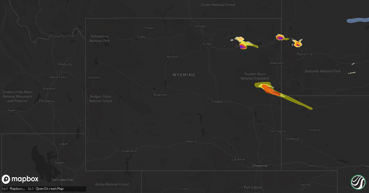
Hail Map in Wyoming on July 17, 2019
Get this storm
July 17 map
$229
one time, instant access
Download today. No call, no setup
Keep the $229
Bought the map and want the full workflow? Apply the entire $229 to a subscription within 7 days. None of it is wasted.
Every map, not just this one
This buys you this map. Subscription and you get every map we run, in the markets you choose from a few cities to whole states to nationwide. Plus real-time alerts the moment a storm fires.
Contact data
Name, contact info, occupancy, even credit band for addresses in the footprint. You go from where it hit to who to call.
Become the source they trust
Unlimited branding weather history reports on demand. You already have the documented answer ready for the property owner, and you are the one who showed up with it.
Property data and RoofTrace estimates
Pull up any address you have got, its value and the exact code rules for that jurisdiction, straight from One Click Code. Then RoofTrace estimates the squares, pitch, and roof value, priced the way you price.
Storm reports in Wyoming
Wyoming
| Date | Description |
|---|---|
| 07/17/20196:59 PM CDT | A local report indicates 2.50 inch wind near 2 S BEULAH |
| 07/17/20196:28 PM CDT | A local report indicates 1.75 inch wind near 6 SE DWTN GILLETTE |
| 07/17/20196:23 PM CDT | A local report indicates 1.00 inch wind near 7 NE LANCE CREEK |
| 07/17/20196:20 PM CDT | Duration 10 minutes. Window damaged. |
| 07/17/20196:15 PM CDT | A local report indicates 1.75 inch wind near 1 ESE DWTN GILLETTE |
| 07/17/20196:15 PM CDT | A local report indicates 2.00 inch wind near DWTN GILLETTE |
| 07/17/20196:10 PM CDT | A local report indicates 2.25 inch wind near 3 SSE DWTN GILLETTE |
| 07/17/20196:02 PM CDT | A local report indicates 1.50 inch wind near 1 S DWTN GILLETTE |
| 07/17/20196:00 PM CDT | Power pole snapped at the base from strong winds. Also had several reports of tennis ball sized hail throughout the northeast portion of gillette causing extensive dama |
| 07/17/20195:56 PM CDT | A local report indicates 1.75 inch wind near 1 N DWTN GILLETTE |
| 07/17/20195:56 PM CDT | Mostly pea size but a few quarter size hail. |
| 07/17/20195:34 PM CDT | A local report indicates 2.00 inch wind near 11 NNW DWTN GILLETTE |
| 07/17/20191:40 AM CDT | At 639 PM MDT, a severe thunderstorm was located 4 miles south of Inyan Kara Mountain, or 17 miles south of Sundance, moving east at 35 mph. HAZARD...60 mph wind gusts and quarter size hail. SOURCE...Radar indicated. IMPACT...Hail damage to vehicles is expected. Expect wind damage to roofs, siding, and trees. Locations impacted include... Four Corners, Buckhorn, Inyan Kara Mountain and Mallo Camp. |
| 07/17/201912:59 AM CDT | At 558 PM MDT, a severe thunderstorm was located 4 miles southwest of Crow Peak, or 9 miles southwest of Spearfish, moving east at 25 mph. HAZARD...Two inch hail and 60 mph wind gusts. SOURCE...Radar indicated. IMPACT...People and animals outdoors will be injured. Expect hail damage to roofs, siding, windows, and vehicles. Expect wind damage to roofs, siding, and trees. Locations impacted include... Spearfish, northwestern Sturgis, Lead, Deadwood, Whitewood, Central City, Beulah, Brownsville, Cheyenne Crossing, Galena, Iron Creek Lake, Apple Springs, Roughlock Falls, Cement Ridge Lookout, Savoy, Bridal Veil Falls, Crow Peak, Terry Peak and Spearfish Canyon.This includes... Interstate 90 in South Dakota between Mile Markers 1 and 29. Interstate 90 in Wyoming between Mile Markers 190 and 207. |
| 07/17/201912:50 AM CDT | At 550 PM MDT, a severe thunderstorm was located 5 miles east of Moorcroft, or 25 miles southwest of Sundance, moving east at 25 mph. HAZARD...Golf ball size hail and 60 mph wind gusts. SOURCE...Satellite and lightning indicated. IMPACT...People and animals outdoors will be injured. Expect hail damage to roofs, siding, windows, and vehicles. Expect wind damage to roofs, siding, and trees. Locations impacted include... Sundance, Upton, Moorcroft, Pine Haven, Osage, Inyan Kara Mountain and Keyhole Reservoir.This includes Interstate 90 in Wyoming between Mile Markers 150 and187. |
| 07/17/201912:40 AM CDT | At 539 PM MDT, a severe thunderstorm was located 12 miles south of Redbird, or 22 miles northeast of Lusk, moving east at 30 mph. HAZARD...Two inch hail and 60 mph wind gusts. SOURCE...Radar indicated. IMPACT...People and animals outdoors will be injured. Expect hail damage to roofs, siding, windows, and vehicles. Expect wind damage to roofs, siding, and trees. This severe thunderstorm will remain over mainly rural areas of northwestern Sioux and east central Niobrara Counties. |
| 07/17/201912:06 AM CDT | At 506 PM MDT, a severe thunderstorm was located 9 miles north of Lance Creek, or 28 miles north of Lusk, moving east at 30 mph. HAZARD...Ping pong ball size hail and 60 mph wind gusts. SOURCE...Radar indicated. IMPACT...People and animals outdoors will be injured. Expect hail damage to roofs, siding, windows, and vehicles. Expect wind damage to roofs, siding, and trees. Locations impacted include... Redbird and Lance Creek. |
| 07/17/201912:05 AM CDT | At 504 PM MDT, a severe thunderstorm was located 6 miles northeast of Camplex Event Facility, or 8 miles northeast of Gillette, moving east at 25 mph. HAZARD...Golf ball size hail and 60 mph wind gusts. SOURCE...Public. IMPACT...People and animals outdoors will be injured. Expect hail damage to roofs, siding, windows, and vehicles. Expect wind damage to roofs, siding, and trees. Hail may accumulate on roadways causing hazardous travel. Locations impacted include... Gillette, Moorcroft, Pine Haven, Rozet, Camplex Event Facility, Keyhole Reservoir and Gillette Airport.This includes Interstate 90 in Wyoming between Mile Markers 124 and160. |
| 07/16/201911:52 PM CDT | At 451 PM MDT, a severe thunderstorm was located near Camplex Event Facility, or 3 miles north of Gillette, moving east at 20 mph. HAZARD...60 mph wind gusts and half dollar size hail. SOURCE...Satellite, lightning, and radar indicated. IMPACT...Hail damage to vehicles is expected. Expect wind damage to roofs, siding, and trees. Locations impacted include... Gillette, Rozet, Camplex Event Facility, and Gillette Airport. This includes Interstate 90 in Wyoming between Mile Markers 120 and151. |
| 07/16/201911:32 PM CDT | At 432 PM MDT, a severe thunderstorm was located 14 miles southeast of Dull Center, or 38 miles north of Lusk, moving east at 25 mph. HAZARD...Ping pong ball size hail and 60 mph wind gusts. SOURCE...Radar indicated. IMPACT...People and animals outdoors will be injured. Expect hail damage to roofs, siding, windows, and vehicles. Expect wind damage to roofs, siding, and trees. Locations impacted include... Redbird. |
| 07/16/201911:14 PM CDT | At 414 PM MDT, a severe thunderstorm was located 9 miles northeast of Gillette Airport, or 12 miles north of Gillette, moving east at 20 mph. HAZARD...60 mph wind gusts and half dollar size hail. SOURCE...Radar indicated. IMPACT...Hail damage to vehicles is expected. Expect wind damage to roofs, siding, and trees. Locations impacted include... Gillette Airport. |
| 07/16/20197:52 PM CDT | A local report indicates a tornado near 1 WSW FOUR CORNERS |
| 07/16/20197:05 PM CDT | Confirmed tornado on the ground. Broken branches. Four to five homes without power. Ping pong ball size hail and heavy rain. |
| 07/16/20197:00 PM CDT | Tree limbs up to 3-4 inches in diameter broken during tornado warned storm |
All States Impacted by Hail Map on July 17, 2019
Cities Impacted by Hail Map on July 17, 2019
- Ottumwa, IA
- Eddyville, IA
- Alberta, MN
- Eldon, IA
- Batavia, IA
- Linton, ND
- Alpine, TX
- Dunlap, IA
- Woodbine, IA
- Marathon, TX
- Fennimore, WI
- Eastman, WI
- Avoca, IA
- Shelby, IA
- Saint Anthony, ND
- Gillette, WY
- Sundance, WY
- Beulah, WY
- Spearfish, SD
- Aladdin, WY
- Granada, MN
- Swea City, IA
- Elmore, MN
- Blue Earth, MN
- Ledyard, IA
- Bronson, FL
- Hillsboro, IA
- Keosauqua, IA
- Bonaparte, IA
- Stockport, IA
- Hebron, ND
- Rudd, IA
- Osage, IA
- Nora Springs, IA
- Rozet, WY
- Manly, IA
- Mason City, IA
- Fort Pierre, SD
- Pierre, SD
- Moorcroft, WY
- Belle Plaine, MN
- Jordan, MN
- New Prague, MN
- Briggsdale, CO
- Pine River, MN
- Lusk, WY
- Lance Creek, WY
- Belfield, ND
- Dickinson, ND
- Northfield, MN
- Solen, ND
- Mandan, ND
- Bottineau, ND
- Osceola, IA
- Murray, IA
- Truro, IA
- Glenwood, MN
- Lakeville, MN
- Prior Lake, MN
- Savage, MN
- Burnsville, MN
- New Leipzig, ND
- Flasher, ND
- Long Valley, SD
- Weldona, CO
- Orchard, CO
- Wanblee, SD
- Elk Horn, IA
- Exira, IA
- Audubon, IA
- Pine Ridge, SD
- Kyle, SD
- Warrenton, MO
- Foristell, MO
- Wright City, MO
- Marthasville, MO
- Shields, ND
- Carson, ND
- Woodman, WI
- Boscobel, WI
- Bismarck, ND
- Maxbass, ND
- Newburg, ND
- Upham, ND
- Sturgis, SD
- Piedmont, SD
- Deadwood, SD
- Winter Haven, FL
- Polk City, FL
- Lakeland, FL
- Auburndale, FL
- Richardton, ND
- Gladstone, ND
- Taylor, ND
- Sherwood, ND
- Harrison, NE
- Whitney, NE
- Crawford, NE
- Chadron, NE
- Mott, ND
- Hayes, VA
- Washington, MO
- Wibaux, MT
- Starbuck, MN
- Benson, MN
- Platteville, WI
- Belmont, WI
- Farmington, MN
- Persia, IA
- Portsmouth, IA
- Harlan, IA
- Kirkman, IA
- Panama, IA
- New Virginia, IA
- Kadoka, SD
- Woden, IA
- Titonka, IA
- Moville, IA
- Saint Paul, MN
- Watford City, ND
- Arnegard, ND
- Fort Yates, ND
- Selfridge, ND
- Earling, IA
- Defiance, IA
- Sioux City, IA
- Elgin, ND
- Alpine, NJ
- Norwood, NJ
- Bayard, IA
- Fort Meade, SD
- Whitewood, SD
- Stitzer, WI
- Big Falls, MN
- Effie, MN
- Coon Rapids, IA
- Livingston, WI
- New Salem, ND
- Savage, MT
- Laddonia, MO
- Martinsburg, MO
- Walnut, IA
- Dunseith, ND
- Kramer, ND
- Graettinger, IA
- Clontarf, MN
- Hancock, MN
- Hastings, MN
- Rosemount, MN
- Medora, ND
- West Des Moines, IA
- Carlsbad, NM
- Webster, FL
- Beach, ND
- Mount Hope, WI
- Elko New Market, MN
- Anthon, IA
- Danbury, IA
- Lawton, IA
- Morriston, FL
- Williston, FL
- Farmington, IA
- Donnellson, IA
- Birmingham, IA
- Manilla, IA
- Emmons, MN
- Kiester, MN
- Scarville, IA
- Backus, MN
- Brooklyn, WI
- Evansville, WI
- Midland, SD
- Karval, CO
- Hugo, CO
- Irwin, IA
- Nokesville, VA
- Fairfield, IA
- Catlett, VA
- Fallon, MT
- Lonsdale, MN
- Webster, MN
- Montgomery, MN
- North Sioux City, SD
- Morris, MN
- Orchard, IA
- Altoona, FL
- Burke, SD
- Panora, IA
- Marfa, TX
- Brooten, MN
- Crane, MT
- Bussey, IA
- Inver Grove Heights, MN
- Atwood, KS
- Strasburg, ND
- Camp Point, IL
- Northome, MN
- Hildreth, NE
- Thompson, IA
- Bristow, VA
- Sentinel Butte, ND
- Mentone, TX
- Lancaster, WI
- Mineral Point, WI
- Cuba City, WI
- Darlington, WI
- Ellis, KS
- Yonkers, NY
- Libertyville, IA
- Fenton, IA
- Ringsted, IA
- Bancroft, IA
- Lone Rock, IA
- Logan, IA
- Catharine, KS
- Glendive, MT
- Wauzeka, WI
- Prairie Du Chien, WI
- Steuben, WI
- Staples, MN
- Gratiot, WI
- Clear Lake, IA
- Plymouth, IA
- Rock Falls, IA
- Floyd, IA
- Rewey, WI
- Hanlontown, IA
- Joice, IA
- Cylinder, IA
- Guthrie Center, IA
- Brooksville, FL
- Kensett, IA
- Waukee, IA
- Urbandale, IA
- Clive, IA
- Bowling Green, FL
- Souris, ND
- Grover, CO
- Kabetogama, MN
- International Falls, MN
- Littlefork, MN
- Orr, MN
- Lewes, DE
- Georgetown, DE
- Milton, DE
- Harbeson, DE
- Carman, IL
- West Burlington, IA
- Morning Sun, IA
- Colchester, IL
- Burlington, IA
- Winfield, IA
- Blandinsville, IL
- Yarmouth, IA
- Wayland, IA
- Sperry, IA
- Brighton, IA
- Mount Union, IA
- Lomax, IL
- Macomb, IL
- Mount Pleasant, IA
- La Harpe, IL
- Dallas City, IL
- Washington, IA
- Sciota, IL
- Mediapolis, IA
- Montrose, IA
- Fort Madison, IA
- Niota, IL
- Keokuk, IA
- West Point, IA
- Nauvoo, IL
- Hamilton, IL
- Carthage, IL
- Tennessee, IL
- Perry, IL
- Eldred, IL
- Wrights, IL
- Hannibal, MO
- Dow, IL
- Jerseyville, IL
- Baylis, IL
- Batchtown, IL
- Medora, IL
- Rockbridge, IL
- Kinderhook, IL
- Elsberry, MO
- Chambersburg, IL
- Carrollton, IL
- Kane, IL
- Saint Charles, MO
- Pleasant Hill, IL
- Payson, IL
- Palmyra, MO
- Meredosia, IL
- Hardin, IL
- Pearl, IL
- Clarksville, MO
- New London, MO
- Foley, MO
- Mount Sterling, IL
- Kampsville, IL
- Patterson, IL
- Versailles, IL
- Brighton, IL
- Griggsville, IL
- Quincy, IL
- Hamburg, IL
- Plainville, IL
- Taylor, MO
- Greenfield, IL
- Coatsburg, IL
- Fieldon, IL
- Roodhouse, IL
- Hillview, IL
- Mendon, IL
- New Canton, IL
- Hull, IL
- Louisiana, MO
- Winchester, IL
- Timewell, IL
- Frankford, MO
- Milton, IL
- Nebo, IL
- Pittsfield, IL
- Annada, MO
- Grafton, IL
- White Hall, IL
- Brussels, IL
- Barry, IL
- Elsah, IL
- Paloma, IL
- Clayton, IL
- Maywood, MO
- Portage Des Sioux, MO
- Fowler, IL
- Ashburn, MO
- Godfrey, IL
- Bluffs, IL
- Rockport, IL
- Liberty, IL
- New Salem, IL
- Lexington, VA
- Douglas, WY
- Edgemont, SD
- Harrold, SD
- Sioux Center, IA
- Alton, IA
- Hospers, IA
- Rock Valley, IA
- Ireton, IA
- Hull, IA
- Alcester, SD
- Boyden, IA
- Sheldon, IA
- Hudson, SD
- Orange City, IA
- Maurice, IA
- Hawarden, IA
- Atlantic, IA
- Kimballton, IA
- Adair, IA
- Anita, IA
- Hamlin, IA
- Marne, IA
- Brayton, IA
- Douglassville, PA
- Lancaster, PA
- Ronks, PA
- Gordonville, PA
- Terre Hill, PA
- Manchester, MD
- Narvon, PA
- Hanover, PA
- Felton, PA
- Smoketown, PA
- Kinzers, PA
- Morgantown, PA
- Glen Rock, PA
- Dallastown, PA
- Elverson, PA
- Shrewsbury, PA
- Spring Grove, PA
- Seven Valleys, PA
- New Freedom, PA
- Willow Street, PA
- East Earl, PA
- Intercourse, PA
- York, PA
- Pottstown, PA
- Boyertown, PA
- Wrightsville, PA
- Airville, PA
- Windsor, PA
- Pequea, PA
- Westminster, MD
- Bird In Hand, PA
- Brogue, PA
- Washington Boro, PA
- Conestoga, PA
- Birdsboro, PA
- Leola, PA
- Red Lion, PA
- Glenville, PA
- Stewartstown, PA
- Strasburg, PA
- Gap, PA
- Mohnton, PA
- Millersville, PA
- New Holland, PA
- Honey Brook, PA
- Paradise, PA
- New Providence, PA
- Parkesburg, PA
- Quarryville, PA
- Coatesville, PA
- Christiana, PA
- Downingtown, PA
- Thorndale, PA
- West Chester, PA
- Kennett Square, PA
- Gilbertville, MA
- Barre, MA
- Petersham, MA
- Hardwick, MA
- Hubbardston, MA
- Westminster, MA
- Lee, MA
- West Stockbridge, MA
- Lenox Dale, MA
- Becket, MA
- Stockbridge, MA
- Richmond, MA
- Lenox, MA
- Old Chatham, NY
- East Chatham, NY
- Nassau, NY
- Canaan, NY
- Malden Bridge, NY
- Valatie, NY
- Wingate, MD
- Crocheron, MD
- Crapo, MD
- Nanticoke, MD
- Hebron, MD
- Bivalve, MD
- Quantico, MD
- Tyaskin, MD
- Eden, MD
- Vienna, MD
- Salisbury, MD
- Toddville, MD
- Fruitland, MD
- Sunburg, MN
- Murdock, MN
- Dupree, SD
- Gettysburg, SD
- Eagle Butte, SD
- Selby, SD
- Charlottesville, VA
- Stanardsville, VA
- Free Union, VA
- Dyke, VA
- Ruckersville, VA
- Earlysville, VA
- Crozet, VA
- Catharpin, VA
- Clifton, VA
- Fairfax, VA
- Haymarket, VA
- Manassas, VA
- Chantilly, VA
- Centreville, VA
- Gainesville, VA
- Warrenton, VA
- Silver Spring, MD
- Hyattsville, MD
- Bethesda, MD
- Cabin John, MD
- Kensington, MD
- Takoma Park, MD
- Chevy Chase, MD
- Glen Echo, MD
- Washington, DC
- Alexandria, VA
- Fort Belvoir, VA
- Dumfries, VA
- Springfield, VA
- Occoquan, VA
- Woodbridge, VA
- Lorton, VA
- Ashburn, VA
- Perryville, MD
- Barnesville, MD
- North East, MD
- Fork, MD
- Woodbine, MD
- Reisterstown, MD
- Leesburg, VA
- Clarksville, MD
- Abingdon, MD
- Perryman, MD
- Fallston, MD
- Derwood, MD
- Forest Hill, MD
- Darlington, MD
- Street, MD
- Olney, MD
- Kingsville, MD
- Nottingham, MD
- Upper Falls, MD
- Havre De Grace, MD
- Boyds, MD
- Aberdeen, MD
- Randallstown, MD
- Clarksburg, MD
- Joppa, MD
- Sparks Glencoe, MD
- Colora, MD
- Phoenix, MD
- Poolesville, MD
- Aberdeen Proving Ground, MD
- Montgomery Village, MD
- Beallsville, MD
- Hunt Valley, MD
- Cooksville, MD
- Parkville, MD
- Conowingo, MD
- Lutherville Timonium, MD
- Pikesville, MD
- Adamstown, MD
- Hydes, MD
- Cockeysville, MD
- Belcamp, MD
- Marriottsville, MD
- Perry Point, MD
- Ellicott City, MD
- Churchville, MD
- Glenwood, MD
- Damascus, MD
- Jarrettsville, MD
- Baltimore, MD
- Windsor Mill, MD
- Mount Airy, MD
- Bel Air, MD
- Owings Mills, MD
- West Friendship, MD
- Edgewood, MD
- Perry Hall, MD
- Dayton, MD
- Dickerson, MD
- Gaithersburg, MD
- Glen Arm, MD
- Glenelg, MD
- Germantown, MD
- Baldwin, MD
- Woodstock, MD
- Towson, MD
- White Marsh, MD
- Sykesville, MD
- Stevenson, MD
- Sterling, VA
- Monkton, MD
- Gwynn Oak, MD
- Port Deposit, MD
- Rising Sun, MD
- Brookeville, MD


