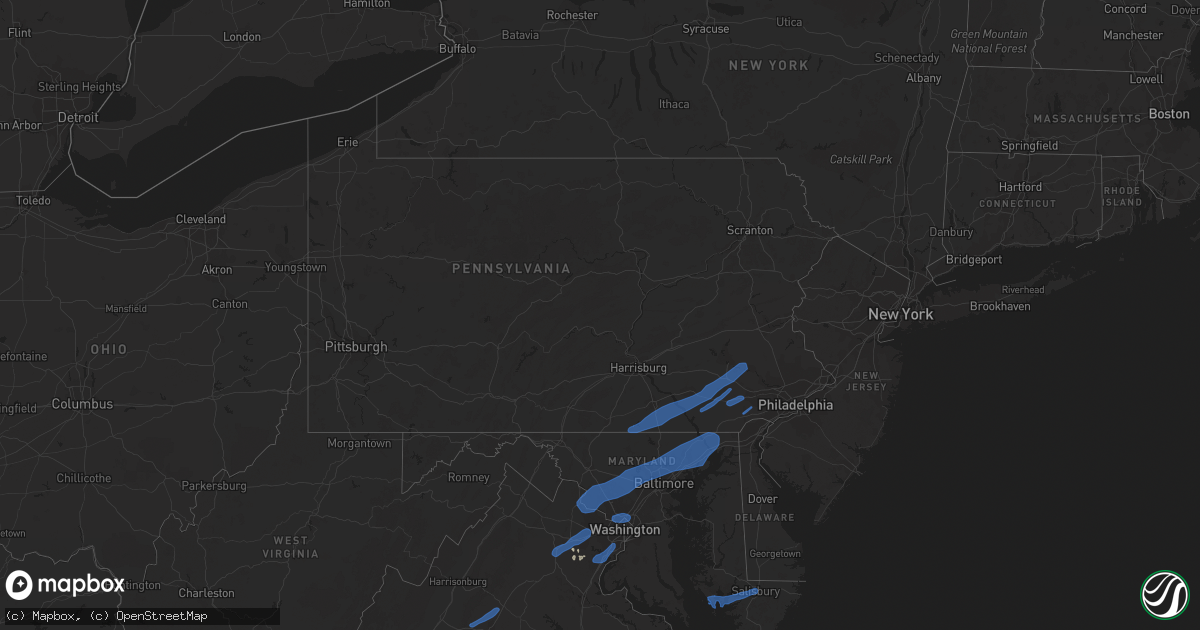
Hail Map in Pennsylvania on July 17, 2019
Get this storm
July 17 map
$229
one time, instant access
Download today. No call, no setup
Keep the $229
Bought the map and want the full workflow? Apply the entire $229 to a subscription within 7 days. None of it is wasted.
Every map, not just this one
This buys you this map. Subscription and you get every map we run, in the markets you choose from a few cities to whole states to nationwide. Plus real-time alerts the moment a storm fires.
Contact data
Name, contact info, occupancy, even credit band for addresses in the footprint. You go from where it hit to who to call.
Become the source they trust
Unlimited branding weather history reports on demand. You already have the documented answer ready for the property owner, and you are the one who showed up with it.
Property data and RoofTrace estimates
Pull up any address you have got, its value and the exact code rules for that jurisdiction, straight from One Click Code. Then RoofTrace estimates the squares, pitch, and roof value, priced the way you price.
Storm reports in Pennsylvania
Pennsylvania
| Date | Description |
|---|---|
| 07/17/20196:55 PM CDT | Poles and wires down. Time estimated from radar. |
| 07/17/20196:46 PM CDT | Poles and wires down on wollaston rd at w street rd. |
| 07/17/20196:45 PM CDT | Wires down. |
| 07/17/20196:27 PM CDT | Tree down and blocking the road on kurtz mill rd at morgantown rd. Time estimated from radar. |
| 07/17/20196:21 PM CDT | Trees and wires down. Time estimated from radar. |
| 07/17/20196:20 PM CDT | Poles and wires down on fisherville rd at n bailey rd. Time estimated from radar. |
| 07/17/20196:17 PM CDT | Report of power poles and wires blown down onto cars near timacula rd at route 372. Time estimated from radar. |
| 07/17/20196:15 PM CDT | Poles and wires down on birdell rd at gooseberry ln. Time estimated from radar. |
| 07/17/20196:03 PM CDT | Tree down on wires. Time estimated from radar. |
| 07/17/20195:56 PM CDT | Multiple trees down on hess rd in upper leacock township. |
| 07/17/20195:53 PM CDT | *** 2 inj *** several people knocked down and a couple vehicles flipped at a factory near the intersection of s custer ave and w jackson st. |
| 07/17/20195:32 PM CDT | Multiple trees down in west lampeter township including at route 222 and east 741 and on beaver valley pike at village rd. |
| 07/17/20195:25 PM CDT | Multiple trees down in and around manor township including at the intersection of river rd and pittsburg hill rd and the intersection of shultz rd and north st. |
| 07/17/20194:58 PM CDT | Wires down on center street |
| 07/17/20194:51 PM CDT | Wires down on blooming grove drive |
| 07/17/20194:40 PM CDT | Wires down on utz drive |
| 07/17/20193:15 AM CDT | At 814 PM EDT, severe thunderstorms were located along a line extending from Dublin to near Buena, moving northeast at 30 mph. HAZARD...60 mph wind gusts. SOURCE...Radar indicated. IMPACT...Damage to roofs, siding, trees, and power lines is possible. Locations impacted include... Philadelphia, Trenton, Camden, Gloucester City, Cherry Hill, Bensalem, Evesham, Mount Laurel, Ewing, Norristown, Willingboro, Deptford, Voorhees, Medford, West Deptford, Glassboro, Lindenwold, Lansdale, West Norriton and Hammonton.People attending Burlington County Farm Fair should seek safe shelterimmediately! |
| 07/17/20191:51 AM CDT | At 650 PM EDT, severe thunderstorms were located along a line extending from Lebanon South to Gap, moving northeast at 40 mph. HAZARD...60 mph wind gusts and penny size hail. SOURCE...Radar indicated. IMPACT...Damage to roofs, siding, trees, and power lines is possible. Locations impacted include... Reading, Pottstown, Wyomissing, Birdsboro, Kutztown, Hamburg, Fleetwood, Sinking Spring, Laureldale, East Greenville, Womelsdorf, Wernersville, Newmanstown, Topton, Leesport, Shoemakersville, Elverson, Bally, Bernville and Bechtelsville. |
| 07/17/20191:39 AM CDT | At 639 PM EDT, severe thunderstorms were located along a line extending from Branchville to near Five Points to near Hope, moving east at 40 mph. HAZARD...60 mph wind gusts and penny size hail. SOURCE...Radar indicated. IMPACT...Damage to roofs, siding, trees, and power lines is possible. Locations impacted include... Newton, Dover, Hopatcong, Kinnelon, Hackettstown, Butler, Wharton, Rockaway, Blairstown, Mount Arlington, Franklin, Mountain Lakes, Stanhope, Riverdale, Hamburg, Netcong, Ogdensburg, Sussex, Hope and Victory Gardens. |
| 07/16/201911:53 PM CDT | At 453 PM EDT, a severe thunderstorm was located near Taneytown, or 8 miles southeast of Emmitsburg, moving northeast at 40 mph. HAZARD...60 mph wind gusts. SOURCE...Radar indicated. IMPACT...Damaging winds will cause some trees and large branches to fall. This could injure those outdoors, as well as damage homes and vehicles. Roadways may become blocked by downed trees. Localized power outages are possible. Unsecured light objects may become projectiles. Locations impacted include... Westminster, Taneytown, Hampstead, Manchester, New Windsor, Union Bridge, Harney, Lineboro, New Midway, Ladiesburg, Rocky Ridge, Linwood, Detour, Uniontown, Millers, Greenmount, Keysville and Keymar. |
| 07/16/20199:00 PM CDT | At 159 PM EDT, a severe thunderstorm was located over Valley-Hi, moving east northeast at 30 mph. HAZARD...60 mph wind gusts. SOURCE...Radar indicated. IMPACT...Expect damage to trees, roofs, and siding. This severe thunderstorm will be near... Wells Tannery around 200 PM EDT. Sideling Hill Rest Area, Waterfall and Saluvia around 210 PM EDT. Fort Littleton around 220 PM EDT.Other locations impacted by this severe thunderstorm include ShadeGap.This includes the following Interstates... Interstate 70 near mile marker 147. The Pennsylvania Turnpike from mile markers 163 to 186. |
| 07/16/20198:57 PM CDT | At 157 PM EDT, a severe thunderstorm was located over Flatbrookville, or 11 miles west of Newton, moving east at 15 mph. HAZARD...60 mph wind gusts and penny size hail. SOURCE...Radar indicated. IMPACT...Damage to roofs, siding, trees, and power lines is possible. Locations impacted include... Newton, Franklin, Ogdensburg, Sussex, Branchville, Flatbrookville, Five Points, Pellettown, Crandon Lakes and Millbrook. |
| 07/16/20197:41 PM CDT | Downed tree on pa-32. Time estimated from radar. |
| 07/16/20197:01 PM CDT | Measured gust to 58mph. |
All States Impacted by Hail Map on July 17, 2019
Cities Impacted by Hail Map on July 17, 2019
- Ottumwa, IA
- Eddyville, IA
- Alberta, MN
- Eldon, IA
- Batavia, IA
- Linton, ND
- Alpine, TX
- Dunlap, IA
- Woodbine, IA
- Marathon, TX
- Fennimore, WI
- Eastman, WI
- Avoca, IA
- Shelby, IA
- Saint Anthony, ND
- Gillette, WY
- Sundance, WY
- Beulah, WY
- Spearfish, SD
- Aladdin, WY
- Granada, MN
- Swea City, IA
- Elmore, MN
- Blue Earth, MN
- Ledyard, IA
- Bronson, FL
- Hillsboro, IA
- Keosauqua, IA
- Bonaparte, IA
- Stockport, IA
- Hebron, ND
- Rudd, IA
- Osage, IA
- Nora Springs, IA
- Rozet, WY
- Manly, IA
- Mason City, IA
- Fort Pierre, SD
- Pierre, SD
- Moorcroft, WY
- Belle Plaine, MN
- Jordan, MN
- New Prague, MN
- Briggsdale, CO
- Pine River, MN
- Lusk, WY
- Lance Creek, WY
- Belfield, ND
- Dickinson, ND
- Northfield, MN
- Solen, ND
- Mandan, ND
- Bottineau, ND
- Osceola, IA
- Murray, IA
- Truro, IA
- Glenwood, MN
- Lakeville, MN
- Prior Lake, MN
- Savage, MN
- Burnsville, MN
- New Leipzig, ND
- Flasher, ND
- Long Valley, SD
- Weldona, CO
- Orchard, CO
- Wanblee, SD
- Elk Horn, IA
- Exira, IA
- Audubon, IA
- Pine Ridge, SD
- Kyle, SD
- Warrenton, MO
- Foristell, MO
- Wright City, MO
- Marthasville, MO
- Shields, ND
- Carson, ND
- Woodman, WI
- Boscobel, WI
- Bismarck, ND
- Maxbass, ND
- Newburg, ND
- Upham, ND
- Sturgis, SD
- Piedmont, SD
- Deadwood, SD
- Winter Haven, FL
- Polk City, FL
- Lakeland, FL
- Auburndale, FL
- Richardton, ND
- Gladstone, ND
- Taylor, ND
- Sherwood, ND
- Harrison, NE
- Whitney, NE
- Crawford, NE
- Chadron, NE
- Mott, ND
- Hayes, VA
- Washington, MO
- Wibaux, MT
- Starbuck, MN
- Benson, MN
- Platteville, WI
- Belmont, WI
- Farmington, MN
- Persia, IA
- Portsmouth, IA
- Harlan, IA
- Kirkman, IA
- Panama, IA
- New Virginia, IA
- Kadoka, SD
- Woden, IA
- Titonka, IA
- Moville, IA
- Saint Paul, MN
- Watford City, ND
- Arnegard, ND
- Fort Yates, ND
- Selfridge, ND
- Earling, IA
- Defiance, IA
- Sioux City, IA
- Elgin, ND
- Alpine, NJ
- Norwood, NJ
- Bayard, IA
- Fort Meade, SD
- Whitewood, SD
- Stitzer, WI
- Big Falls, MN
- Effie, MN
- Coon Rapids, IA
- Livingston, WI
- New Salem, ND
- Savage, MT
- Laddonia, MO
- Martinsburg, MO
- Walnut, IA
- Dunseith, ND
- Kramer, ND
- Graettinger, IA
- Clontarf, MN
- Hancock, MN
- Hastings, MN
- Rosemount, MN
- Medora, ND
- West Des Moines, IA
- Carlsbad, NM
- Webster, FL
- Beach, ND
- Mount Hope, WI
- Elko New Market, MN
- Anthon, IA
- Danbury, IA
- Lawton, IA
- Morriston, FL
- Williston, FL
- Farmington, IA
- Donnellson, IA
- Birmingham, IA
- Manilla, IA
- Emmons, MN
- Kiester, MN
- Scarville, IA
- Backus, MN
- Brooklyn, WI
- Evansville, WI
- Midland, SD
- Karval, CO
- Hugo, CO
- Irwin, IA
- Nokesville, VA
- Fairfield, IA
- Catlett, VA
- Fallon, MT
- Lonsdale, MN
- Webster, MN
- Montgomery, MN
- North Sioux City, SD
- Morris, MN
- Orchard, IA
- Altoona, FL
- Burke, SD
- Panora, IA
- Marfa, TX
- Brooten, MN
- Crane, MT
- Bussey, IA
- Inver Grove Heights, MN
- Atwood, KS
- Strasburg, ND
- Camp Point, IL
- Northome, MN
- Hildreth, NE
- Thompson, IA
- Bristow, VA
- Sentinel Butte, ND
- Mentone, TX
- Lancaster, WI
- Mineral Point, WI
- Cuba City, WI
- Darlington, WI
- Ellis, KS
- Yonkers, NY
- Libertyville, IA
- Fenton, IA
- Ringsted, IA
- Bancroft, IA
- Lone Rock, IA
- Logan, IA
- Catharine, KS
- Glendive, MT
- Wauzeka, WI
- Prairie Du Chien, WI
- Steuben, WI
- Staples, MN
- Gratiot, WI
- Clear Lake, IA
- Plymouth, IA
- Rock Falls, IA
- Floyd, IA
- Rewey, WI
- Hanlontown, IA
- Joice, IA
- Cylinder, IA
- Guthrie Center, IA
- Brooksville, FL
- Kensett, IA
- Waukee, IA
- Urbandale, IA
- Clive, IA
- Bowling Green, FL
- Souris, ND
- Grover, CO
- Kabetogama, MN
- International Falls, MN
- Littlefork, MN
- Orr, MN
- Lewes, DE
- Georgetown, DE
- Milton, DE
- Harbeson, DE
- Carman, IL
- West Burlington, IA
- Morning Sun, IA
- Colchester, IL
- Burlington, IA
- Winfield, IA
- Blandinsville, IL
- Yarmouth, IA
- Wayland, IA
- Sperry, IA
- Brighton, IA
- Mount Union, IA
- Lomax, IL
- Macomb, IL
- Mount Pleasant, IA
- La Harpe, IL
- Dallas City, IL
- Washington, IA
- Sciota, IL
- Mediapolis, IA
- Montrose, IA
- Fort Madison, IA
- Niota, IL
- Keokuk, IA
- West Point, IA
- Nauvoo, IL
- Hamilton, IL
- Carthage, IL
- Tennessee, IL
- Perry, IL
- Eldred, IL
- Wrights, IL
- Hannibal, MO
- Dow, IL
- Jerseyville, IL
- Baylis, IL
- Batchtown, IL
- Medora, IL
- Rockbridge, IL
- Kinderhook, IL
- Elsberry, MO
- Chambersburg, IL
- Carrollton, IL
- Kane, IL
- Saint Charles, MO
- Pleasant Hill, IL
- Payson, IL
- Palmyra, MO
- Meredosia, IL
- Hardin, IL
- Pearl, IL
- Clarksville, MO
- New London, MO
- Foley, MO
- Mount Sterling, IL
- Kampsville, IL
- Patterson, IL
- Versailles, IL
- Brighton, IL
- Griggsville, IL
- Quincy, IL
- Hamburg, IL
- Plainville, IL
- Taylor, MO
- Greenfield, IL
- Coatsburg, IL
- Fieldon, IL
- Roodhouse, IL
- Hillview, IL
- Mendon, IL
- New Canton, IL
- Hull, IL
- Louisiana, MO
- Winchester, IL
- Timewell, IL
- Frankford, MO
- Milton, IL
- Nebo, IL
- Pittsfield, IL
- Annada, MO
- Grafton, IL
- White Hall, IL
- Brussels, IL
- Barry, IL
- Elsah, IL
- Paloma, IL
- Clayton, IL
- Maywood, MO
- Portage Des Sioux, MO
- Fowler, IL
- Ashburn, MO
- Godfrey, IL
- Bluffs, IL
- Rockport, IL
- Liberty, IL
- New Salem, IL
- Lexington, VA
- Douglas, WY
- Edgemont, SD
- Harrold, SD
- Sioux Center, IA
- Alton, IA
- Hospers, IA
- Rock Valley, IA
- Ireton, IA
- Hull, IA
- Alcester, SD
- Boyden, IA
- Sheldon, IA
- Hudson, SD
- Orange City, IA
- Maurice, IA
- Hawarden, IA
- Atlantic, IA
- Kimballton, IA
- Adair, IA
- Anita, IA
- Hamlin, IA
- Marne, IA
- Brayton, IA
- Douglassville, PA
- Lancaster, PA
- Ronks, PA
- Gordonville, PA
- Terre Hill, PA
- Manchester, MD
- Narvon, PA
- Hanover, PA
- Felton, PA
- Smoketown, PA
- Kinzers, PA
- Morgantown, PA
- Glen Rock, PA
- Dallastown, PA
- Elverson, PA
- Shrewsbury, PA
- Spring Grove, PA
- Seven Valleys, PA
- New Freedom, PA
- Willow Street, PA
- East Earl, PA
- Intercourse, PA
- York, PA
- Pottstown, PA
- Boyertown, PA
- Wrightsville, PA
- Airville, PA
- Windsor, PA
- Pequea, PA
- Westminster, MD
- Bird In Hand, PA
- Brogue, PA
- Washington Boro, PA
- Conestoga, PA
- Birdsboro, PA
- Leola, PA
- Red Lion, PA
- Glenville, PA
- Stewartstown, PA
- Strasburg, PA
- Gap, PA
- Mohnton, PA
- Millersville, PA
- New Holland, PA
- Honey Brook, PA
- Paradise, PA
- New Providence, PA
- Parkesburg, PA
- Quarryville, PA
- Coatesville, PA
- Christiana, PA
- Downingtown, PA
- Thorndale, PA
- West Chester, PA
- Kennett Square, PA
- Gilbertville, MA
- Barre, MA
- Petersham, MA
- Hardwick, MA
- Hubbardston, MA
- Westminster, MA
- Lee, MA
- West Stockbridge, MA
- Lenox Dale, MA
- Becket, MA
- Stockbridge, MA
- Richmond, MA
- Lenox, MA
- Old Chatham, NY
- East Chatham, NY
- Nassau, NY
- Canaan, NY
- Malden Bridge, NY
- Valatie, NY
- Wingate, MD
- Crocheron, MD
- Crapo, MD
- Nanticoke, MD
- Hebron, MD
- Bivalve, MD
- Quantico, MD
- Tyaskin, MD
- Eden, MD
- Vienna, MD
- Salisbury, MD
- Toddville, MD
- Fruitland, MD
- Sunburg, MN
- Murdock, MN
- Dupree, SD
- Gettysburg, SD
- Eagle Butte, SD
- Selby, SD
- Charlottesville, VA
- Stanardsville, VA
- Free Union, VA
- Dyke, VA
- Ruckersville, VA
- Earlysville, VA
- Crozet, VA
- Catharpin, VA
- Clifton, VA
- Fairfax, VA
- Haymarket, VA
- Manassas, VA
- Chantilly, VA
- Centreville, VA
- Gainesville, VA
- Warrenton, VA
- Silver Spring, MD
- Hyattsville, MD
- Bethesda, MD
- Cabin John, MD
- Kensington, MD
- Takoma Park, MD
- Chevy Chase, MD
- Glen Echo, MD
- Washington, DC
- Alexandria, VA
- Fort Belvoir, VA
- Dumfries, VA
- Springfield, VA
- Occoquan, VA
- Woodbridge, VA
- Lorton, VA
- Ashburn, VA
- Perryville, MD
- Barnesville, MD
- North East, MD
- Fork, MD
- Woodbine, MD
- Reisterstown, MD
- Leesburg, VA
- Clarksville, MD
- Abingdon, MD
- Perryman, MD
- Fallston, MD
- Derwood, MD
- Forest Hill, MD
- Darlington, MD
- Street, MD
- Olney, MD
- Kingsville, MD
- Nottingham, MD
- Upper Falls, MD
- Havre De Grace, MD
- Boyds, MD
- Aberdeen, MD
- Randallstown, MD
- Clarksburg, MD
- Joppa, MD
- Sparks Glencoe, MD
- Colora, MD
- Phoenix, MD
- Poolesville, MD
- Aberdeen Proving Ground, MD
- Montgomery Village, MD
- Beallsville, MD
- Hunt Valley, MD
- Cooksville, MD
- Parkville, MD
- Conowingo, MD
- Lutherville Timonium, MD
- Pikesville, MD
- Adamstown, MD
- Hydes, MD
- Cockeysville, MD
- Belcamp, MD
- Marriottsville, MD
- Perry Point, MD
- Ellicott City, MD
- Churchville, MD
- Glenwood, MD
- Damascus, MD
- Jarrettsville, MD
- Baltimore, MD
- Windsor Mill, MD
- Mount Airy, MD
- Bel Air, MD
- Owings Mills, MD
- West Friendship, MD
- Edgewood, MD
- Perry Hall, MD
- Dayton, MD
- Dickerson, MD
- Gaithersburg, MD
- Glen Arm, MD
- Glenelg, MD
- Germantown, MD
- Baldwin, MD
- Woodstock, MD
- Towson, MD
- White Marsh, MD
- Sykesville, MD
- Stevenson, MD
- Sterling, VA
- Monkton, MD
- Gwynn Oak, MD
- Port Deposit, MD
- Rising Sun, MD
- Brookeville, MD


