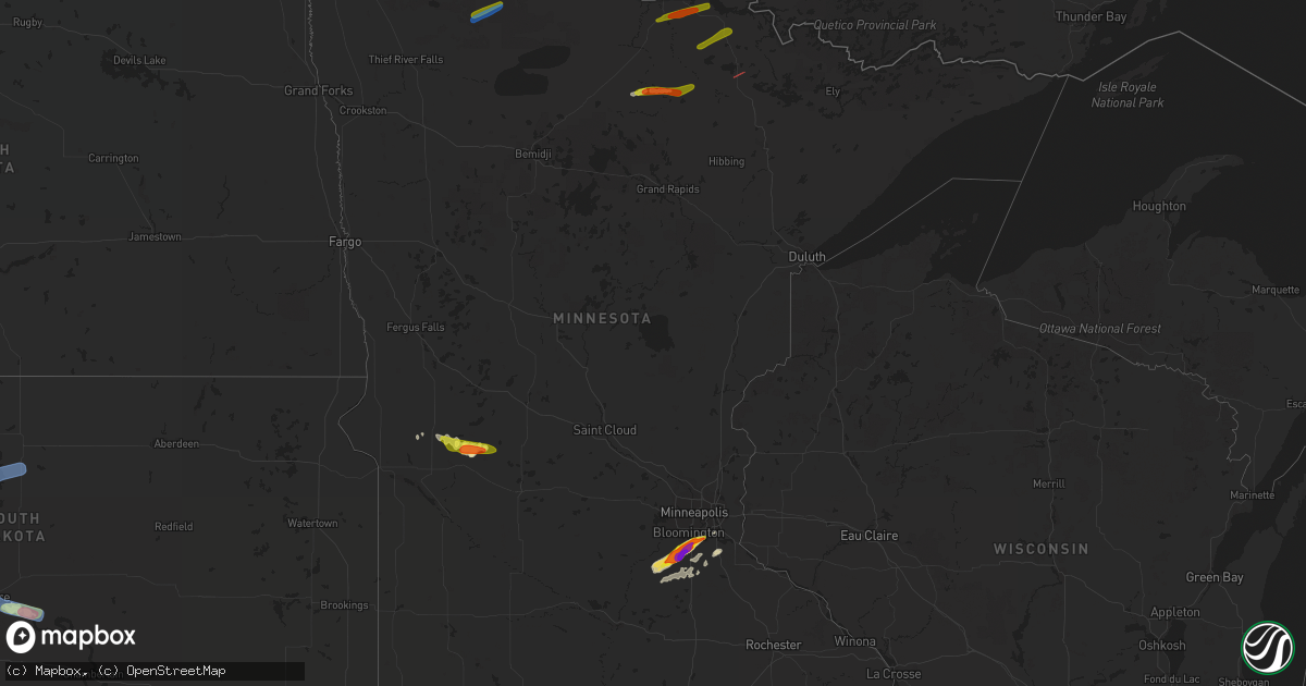
Hail Map in Minnesota on July 17, 2019
Get this storm
July 17 map
$229
one time, instant access
Download today. No call, no setup
Keep the $229
Bought the map and want the full workflow? Apply the entire $229 to a subscription within 7 days. None of it is wasted.
Every map, not just this one
This buys you this map. Subscription and you get every map we run, in the markets you choose from a few cities to whole states to nationwide. Plus real-time alerts the moment a storm fires.
Contact data
Name, contact info, occupancy, even credit band for addresses in the footprint. You go from where it hit to who to call.
Become the source they trust
Unlimited branding weather history reports on demand. You already have the documented answer ready for the property owner, and you are the one who showed up with it.
Property data and RoofTrace estimates
Pull up any address you have got, its value and the exact code rules for that jurisdiction, straight from One Click Code. Then RoofTrace estimates the squares, pitch, and roof value, priced the way you price.
Storm reports in Minnesota
Minnesota
| Date | Description |
|---|---|
| 07/17/20196:49 PM CDT | Trees down along highway 65 near littlefork and trees down knocking down powerlines in littlefork. Time estimated by radar. |
| 07/17/20196:49 PM CDT | Bleachers damaged at fairgrounds in littlefork. Tree down on a powerline in littlefork. Time estimated by radar. |
| 07/17/20196:20 PM CDT | Mndot road weather station station mn026 brichdale mn-11 mile post 157. |
| 07/17/20196:20 PM CDT | Numerous large tree branches broken down along the rainy river. |
| 07/17/20196:00 PM CDT | Law enforcement reported a funnel cloud that touched down briefly on county road 14 near county road 31 heading east towards bigfork. Location estimated by radar. |
| 07/17/20196:34 AM CDT | At 1133 PM CDT, a severe thunderstorm was located over eastern Boundary Waters Canoe Area Wilderness, or 26 miles west of Gunflint Lake, moving east at 40 mph. HAZARD...70 mph wind gusts and quarter size hail. SOURCE...Radar indicated. IMPACT...Hail damage to vehicles is expected. Expect considerable tree damage. Wind damage is also likely to mobile homes, roofs, and outbuildings. Locations impacted include... Gunflint Lake, Eagle Mountain, Boundary Waters Canoe Area Wilderness North of the Gunflint Trail, Snowbank Lake, Eastern Boundary Waters Canoe Area Wilderness, Little Saganaga Lake, Basswood Lake, Ensign Lake, Bearskin Lake, Kekekabic Lake, Alice Lake, Phoebe Lake, North Lake, Kawishiwi Lake, Disappointment Lake, Lake Three, Gabimichigami Lake, Hudson Lake, Brule Lake, and Cherokee Lake. |
| 07/17/20194:56 AM CDT | At 956 PM CDT, severe thunderstorms were located along a line extending from Boundary Waters Canoe Area Wilderness, to 6 miles northeast of Burntside Lake, moving east at 25 mph. HAZARD...60 mph wind gusts and half dollar size hail. SOURCE...Radar indicated. IMPACT...Hail damage to vehicles is expected. Expect wind damage to roofs, siding, and trees. Severe thunderstorms will be near... Fall Lake around 1020 PM CDT. Basswood Lake around 1040 PM CDT. Snowbank Lake around 1055 PM CDT. Saganaga Lake around 1100 PM CDT.Other locations impacted by these severe thunderstorms include EnsignLake, Kekekabic Lake, Disappointment Lake, Thomas Lake, High Lake,Knife Lake, Fourtown Lake and Crooked Lake. |
| 07/17/20194:35 AM CDT | Reported via twitter with pictures. |
| 07/17/20194:30 AM CDT | A local report indicates 1.25 inch wind near SAVAGE |
| 07/17/20194:25 AM CDT | Time estimated from radar. Report via twitter with picture+ruler. |
| 07/17/20194:25 AM CDT | A local report indicates 1.75 inch wind near 1 SSW PRIOR LAKE |
| 07/17/20194:21 AM CDT | Hail started at 4:21am and lasted until 4:33am. |
| 07/17/20194:13 AM CDT | At 912 PM CDT, a severe thunderstorm was located over the western part of the Boundary Waters Canoe Area Wilderness, or 21 miles northeast of Lake Vermilion, moving east at 30 mph. HAZARD...70 mph wind gusts and quarter size hail. SOURCE...Radar indicated. IMPACT...Hail damage to vehicles is expected. Expect considerable tree damage. Locations impacted include... Basswood Lake, Lake Agnes, Crooked Lake, Loon Lake, and Lac la Croix. |
| 07/17/20194:01 AM CDT | At 901 PM CDT, severe thunderstorms were located along a line extending from 8 miles east of Voyageurs National Park, to 6 miles southeast of Kabetogama, moving east at 25 mph. HAZARD...70 mph wind gusts and penny size hail. SOURCE...Radar indicated. IMPACT...Expect considerable tree damage. Damage is likely to mobile homes, roofs, and outbuildings. Locations impacted include... Voyageurs National Park, Kabetogama Lake, Crane lake, and Sand Point Lake. |
| 07/17/20193:18 AM CDT | At 817 PM CDT, a severe thunderstorm was located near Rainy Lake West, or 15 miles east of International Falls, moving east at 60 mph. HAZARD...70 mph wind gusts and penny size hail. SOURCE...Radar indicated. IMPACT...Expect considerable tree damage. Damage is likely to mobile homes, roofs, and outbuildings. Locations impacted include... Rainy Lake, Kabetogama Lake, Voyageurs National Park, Kettle Falls, and Island View. |
| 07/17/20193:10 AM CDT | At 809 PM CDT, a severe thunderstorm was located 8 miles west of Ash Lake, or 27 miles southeast of International Falls, moving northeast at 35 mph. HAZARD...Golf ball size hail and 60 mph wind gusts. SOURCE...Radar indicated. IMPACT...People and animals outdoors will be injured. Expect hail damage to roofs, siding, windows, and vehicles. Expect wind damage to roofs, siding, and trees. Locations impacted include... Voyageurs National Park, Kabetogama Lake, Bois Forte Reservation, and Highway 53 between Ash lake and Kabetogama. |
| 07/17/20192:45 AM CDT | At 744 PM CDT, a severe thunderstorm was located 7 miles southwest of Pelican Lake, or 29 miles west of Lake Vermilion, moving east at 30 mph. HAZARD...Ping pong ball size hail and 60 mph wind gusts. SOURCE...Radar indicated. IMPACT...People and animals outdoors will be injured. Expect hail damage to roofs, siding, windows, and vehicles. Expect wind damage to roofs, siding, and trees. Locations impacted include... Orr, Gheen, Pelican Lake, Cusson, Greaney, and Bois Forte Reservation. |
| 07/17/20192:15 AM CDT | At 715 PM CDT, a severe thunderstorm was located 3 miles north of Togo, moving east at 30 mph. HAZARD...60 mph wind gusts and quarter size hail. SOURCE...Radar indicated. IMPACT...Hail damage to vehicles is expected. Expect wind damage to roofs, siding, and trees. Locations impacted include... Orr, Gheen, Pelican Lake, Celina, Greaney, Bois Forte Reservation, and Highway 53 between Cook and Orr. |
| 07/17/20191:24 AM CDT | At 624 PM CDT, a severe thunderstorm was located 17 miles south of Baudette, moving east at 35 mph. HAZARD...60 mph wind gusts and quarter size hail. SOURCE...Radar indicated. IMPACT...Hail damage to vehicles is expected. Expect wind damage to roofs, siding, and trees. Locations impacted include... Birchdale, Loman, Manitou, Indus, and Franz Jevne State Park. |
| 07/17/20191:11 AM CDT | At 611 PM CDT, a severe thunderstorm was located near Carp, or 57 miles southeast of Roseau, moving east at 30 mph. HAZARD...60 mph wind gusts and quarter size hail. SOURCE...Radar indicated. IMPACT...Hail damage to vehicles is expected. Expect wind damage to roofs, siding, and trees. This severe thunderstorm will remain over mainly rural areas of southeastern Lake of the Woods County. |
| 07/17/20191:07 AM CDT | At 607 PM CDT, a severe thunderstorm was located 7 miles northwest of Big Falls, or 35 miles southwest of International Falls, moving northeast at 25 mph. HAZARD...60 mph wind gusts and quarter size hail. SOURCE...Radar indicated. IMPACT...Hail damage to vehicles is expected. Expect wind damage to roofs, siding, and trees. Locations impacted include... Littlefork, Big Falls, and Grand Falls. |
| 07/17/201912:27 AM CDT | At 526 PM CDT, a severe thunderstorm was located 10 miles south of Baudette, moving east at 20 mph. HAZARD...60 mph wind gusts and penny size hail. SOURCE...Radar indicated. IMPACT...Expect damage to roofs, siding, and trees. Locations impacted include... Birchdale, Manitou, Indus, and Franz Jevne State Park. |
| 07/17/201912:26 AM CDT | At 526 PM CDT, a severe thunderstorm was located just north of Alvwood, or 37 miles northeast of Bemidji, moving northeast at 20 mph. HAZARD...60 mph wind gusts and nickel size hail. SOURCE...Radar indicated. IMPACT...Expect damage to roofs, siding, and trees. Locations impacted include... Northome, Alvwood, and Orth. |
| 07/17/201912:06 AM CDT | At 505 PM CDT, a severe thunderstorm was located over Carp, moving east at 25 mph. HAZARD...60 mph wind gusts and quarter size hail. SOURCE...Radar indicated. IMPACT...Hail damage to vehicles is expected. Expect wind damage to roofs, siding, and trees. This severe thunderstorm will remain over mainly rural areas of southeastern Lake of the Woods County. |
| 07/16/201910:37 PM CDT | At 337 PM CDT, a severe thunderstorm was located near Gates Corner, or 32 miles southeast of Roseau, moving northeast at 20 mph. HAZARD...60 mph wind gusts and quarter size hail. SOURCE...Radar indicated. IMPACT...Hail damage to vehicles is expected. Expect wind damage to roofs, siding, and trees. This severe thunderstorm will be near... Gates Corner around 355 PM CDT. Norris Camp around 430 PM CDT. |
| 07/16/20198:33 PM CDT | Tree damage with the damage path approximately 200 yards wide for about a mile. Downed trees ranged in diameter from 6 inches to 3 feet. Trees fell in different directi |
| 07/16/20198:10 PM CDT | Small debris lofted by tornado with funnel seen. Tornado headed east towards elbow lake. |
| 07/16/20198:07 PM CDT | A trained spotter reported a storm with heavy rotation and a tornado on the ground just south of orr... Near us highway 53. |
| 07/16/20197:45 PM CDT | 5 pine and popple trees that were about 2 feet in diameter knocked down due to straight line winds. |
All States Impacted by Hail Map on July 17, 2019
Cities Impacted by Hail Map on July 17, 2019
- Ottumwa, IA
- Eddyville, IA
- Alberta, MN
- Eldon, IA
- Batavia, IA
- Linton, ND
- Alpine, TX
- Dunlap, IA
- Woodbine, IA
- Marathon, TX
- Fennimore, WI
- Eastman, WI
- Avoca, IA
- Shelby, IA
- Saint Anthony, ND
- Gillette, WY
- Sundance, WY
- Beulah, WY
- Spearfish, SD
- Aladdin, WY
- Granada, MN
- Swea City, IA
- Elmore, MN
- Blue Earth, MN
- Ledyard, IA
- Bronson, FL
- Hillsboro, IA
- Keosauqua, IA
- Bonaparte, IA
- Stockport, IA
- Hebron, ND
- Rudd, IA
- Osage, IA
- Nora Springs, IA
- Rozet, WY
- Manly, IA
- Mason City, IA
- Fort Pierre, SD
- Pierre, SD
- Moorcroft, WY
- Belle Plaine, MN
- Jordan, MN
- New Prague, MN
- Briggsdale, CO
- Pine River, MN
- Lusk, WY
- Lance Creek, WY
- Belfield, ND
- Dickinson, ND
- Northfield, MN
- Solen, ND
- Mandan, ND
- Bottineau, ND
- Osceola, IA
- Murray, IA
- Truro, IA
- Glenwood, MN
- Lakeville, MN
- Prior Lake, MN
- Savage, MN
- Burnsville, MN
- New Leipzig, ND
- Flasher, ND
- Long Valley, SD
- Weldona, CO
- Orchard, CO
- Wanblee, SD
- Elk Horn, IA
- Exira, IA
- Audubon, IA
- Pine Ridge, SD
- Kyle, SD
- Warrenton, MO
- Foristell, MO
- Wright City, MO
- Marthasville, MO
- Shields, ND
- Carson, ND
- Woodman, WI
- Boscobel, WI
- Bismarck, ND
- Maxbass, ND
- Newburg, ND
- Upham, ND
- Sturgis, SD
- Piedmont, SD
- Deadwood, SD
- Winter Haven, FL
- Polk City, FL
- Lakeland, FL
- Auburndale, FL
- Richardton, ND
- Gladstone, ND
- Taylor, ND
- Sherwood, ND
- Harrison, NE
- Whitney, NE
- Crawford, NE
- Chadron, NE
- Mott, ND
- Hayes, VA
- Washington, MO
- Wibaux, MT
- Starbuck, MN
- Benson, MN
- Platteville, WI
- Belmont, WI
- Farmington, MN
- Persia, IA
- Portsmouth, IA
- Harlan, IA
- Kirkman, IA
- Panama, IA
- New Virginia, IA
- Kadoka, SD
- Woden, IA
- Titonka, IA
- Moville, IA
- Saint Paul, MN
- Watford City, ND
- Arnegard, ND
- Fort Yates, ND
- Selfridge, ND
- Earling, IA
- Defiance, IA
- Sioux City, IA
- Elgin, ND
- Alpine, NJ
- Norwood, NJ
- Bayard, IA
- Fort Meade, SD
- Whitewood, SD
- Stitzer, WI
- Big Falls, MN
- Effie, MN
- Coon Rapids, IA
- Livingston, WI
- New Salem, ND
- Savage, MT
- Laddonia, MO
- Martinsburg, MO
- Walnut, IA
- Dunseith, ND
- Kramer, ND
- Graettinger, IA
- Clontarf, MN
- Hancock, MN
- Hastings, MN
- Rosemount, MN
- Medora, ND
- West Des Moines, IA
- Carlsbad, NM
- Webster, FL
- Beach, ND
- Mount Hope, WI
- Elko New Market, MN
- Anthon, IA
- Danbury, IA
- Lawton, IA
- Morriston, FL
- Williston, FL
- Farmington, IA
- Donnellson, IA
- Birmingham, IA
- Manilla, IA
- Emmons, MN
- Kiester, MN
- Scarville, IA
- Backus, MN
- Brooklyn, WI
- Evansville, WI
- Midland, SD
- Karval, CO
- Hugo, CO
- Irwin, IA
- Nokesville, VA
- Fairfield, IA
- Catlett, VA
- Fallon, MT
- Lonsdale, MN
- Webster, MN
- Montgomery, MN
- North Sioux City, SD
- Morris, MN
- Orchard, IA
- Altoona, FL
- Burke, SD
- Panora, IA
- Marfa, TX
- Brooten, MN
- Crane, MT
- Bussey, IA
- Inver Grove Heights, MN
- Atwood, KS
- Strasburg, ND
- Camp Point, IL
- Northome, MN
- Hildreth, NE
- Thompson, IA
- Bristow, VA
- Sentinel Butte, ND
- Mentone, TX
- Lancaster, WI
- Mineral Point, WI
- Cuba City, WI
- Darlington, WI
- Ellis, KS
- Yonkers, NY
- Libertyville, IA
- Fenton, IA
- Ringsted, IA
- Bancroft, IA
- Lone Rock, IA
- Logan, IA
- Catharine, KS
- Glendive, MT
- Wauzeka, WI
- Prairie Du Chien, WI
- Steuben, WI
- Staples, MN
- Gratiot, WI
- Clear Lake, IA
- Plymouth, IA
- Rock Falls, IA
- Floyd, IA
- Rewey, WI
- Hanlontown, IA
- Joice, IA
- Cylinder, IA
- Guthrie Center, IA
- Brooksville, FL
- Kensett, IA
- Waukee, IA
- Urbandale, IA
- Clive, IA
- Bowling Green, FL
- Souris, ND
- Grover, CO
- Kabetogama, MN
- International Falls, MN
- Littlefork, MN
- Orr, MN
- Lewes, DE
- Georgetown, DE
- Milton, DE
- Harbeson, DE
- Carman, IL
- West Burlington, IA
- Morning Sun, IA
- Colchester, IL
- Burlington, IA
- Winfield, IA
- Blandinsville, IL
- Yarmouth, IA
- Wayland, IA
- Sperry, IA
- Brighton, IA
- Mount Union, IA
- Lomax, IL
- Macomb, IL
- Mount Pleasant, IA
- La Harpe, IL
- Dallas City, IL
- Washington, IA
- Sciota, IL
- Mediapolis, IA
- Montrose, IA
- Fort Madison, IA
- Niota, IL
- Keokuk, IA
- West Point, IA
- Nauvoo, IL
- Hamilton, IL
- Carthage, IL
- Tennessee, IL
- Perry, IL
- Eldred, IL
- Wrights, IL
- Hannibal, MO
- Dow, IL
- Jerseyville, IL
- Baylis, IL
- Batchtown, IL
- Medora, IL
- Rockbridge, IL
- Kinderhook, IL
- Elsberry, MO
- Chambersburg, IL
- Carrollton, IL
- Kane, IL
- Saint Charles, MO
- Pleasant Hill, IL
- Payson, IL
- Palmyra, MO
- Meredosia, IL
- Hardin, IL
- Pearl, IL
- Clarksville, MO
- New London, MO
- Foley, MO
- Mount Sterling, IL
- Kampsville, IL
- Patterson, IL
- Versailles, IL
- Brighton, IL
- Griggsville, IL
- Quincy, IL
- Hamburg, IL
- Plainville, IL
- Taylor, MO
- Greenfield, IL
- Coatsburg, IL
- Fieldon, IL
- Roodhouse, IL
- Hillview, IL
- Mendon, IL
- New Canton, IL
- Hull, IL
- Louisiana, MO
- Winchester, IL
- Timewell, IL
- Frankford, MO
- Milton, IL
- Nebo, IL
- Pittsfield, IL
- Annada, MO
- Grafton, IL
- White Hall, IL
- Brussels, IL
- Barry, IL
- Elsah, IL
- Paloma, IL
- Clayton, IL
- Maywood, MO
- Portage Des Sioux, MO
- Fowler, IL
- Ashburn, MO
- Godfrey, IL
- Bluffs, IL
- Rockport, IL
- Liberty, IL
- New Salem, IL
- Lexington, VA
- Douglas, WY
- Edgemont, SD
- Harrold, SD
- Sioux Center, IA
- Alton, IA
- Hospers, IA
- Rock Valley, IA
- Ireton, IA
- Hull, IA
- Alcester, SD
- Boyden, IA
- Sheldon, IA
- Hudson, SD
- Orange City, IA
- Maurice, IA
- Hawarden, IA
- Atlantic, IA
- Kimballton, IA
- Adair, IA
- Anita, IA
- Hamlin, IA
- Marne, IA
- Brayton, IA
- Douglassville, PA
- Lancaster, PA
- Ronks, PA
- Gordonville, PA
- Terre Hill, PA
- Manchester, MD
- Narvon, PA
- Hanover, PA
- Felton, PA
- Smoketown, PA
- Kinzers, PA
- Morgantown, PA
- Glen Rock, PA
- Dallastown, PA
- Elverson, PA
- Shrewsbury, PA
- Spring Grove, PA
- Seven Valleys, PA
- New Freedom, PA
- Willow Street, PA
- East Earl, PA
- Intercourse, PA
- York, PA
- Pottstown, PA
- Boyertown, PA
- Wrightsville, PA
- Airville, PA
- Windsor, PA
- Pequea, PA
- Westminster, MD
- Bird In Hand, PA
- Brogue, PA
- Washington Boro, PA
- Conestoga, PA
- Birdsboro, PA
- Leola, PA
- Red Lion, PA
- Glenville, PA
- Stewartstown, PA
- Strasburg, PA
- Gap, PA
- Mohnton, PA
- Millersville, PA
- New Holland, PA
- Honey Brook, PA
- Paradise, PA
- New Providence, PA
- Parkesburg, PA
- Quarryville, PA
- Coatesville, PA
- Christiana, PA
- Downingtown, PA
- Thorndale, PA
- West Chester, PA
- Kennett Square, PA
- Gilbertville, MA
- Barre, MA
- Petersham, MA
- Hardwick, MA
- Hubbardston, MA
- Westminster, MA
- Lee, MA
- West Stockbridge, MA
- Lenox Dale, MA
- Becket, MA
- Stockbridge, MA
- Richmond, MA
- Lenox, MA
- Old Chatham, NY
- East Chatham, NY
- Nassau, NY
- Canaan, NY
- Malden Bridge, NY
- Valatie, NY
- Wingate, MD
- Crocheron, MD
- Crapo, MD
- Nanticoke, MD
- Hebron, MD
- Bivalve, MD
- Quantico, MD
- Tyaskin, MD
- Eden, MD
- Vienna, MD
- Salisbury, MD
- Toddville, MD
- Fruitland, MD
- Sunburg, MN
- Murdock, MN
- Dupree, SD
- Gettysburg, SD
- Eagle Butte, SD
- Selby, SD
- Charlottesville, VA
- Stanardsville, VA
- Free Union, VA
- Dyke, VA
- Ruckersville, VA
- Earlysville, VA
- Crozet, VA
- Catharpin, VA
- Clifton, VA
- Fairfax, VA
- Haymarket, VA
- Manassas, VA
- Chantilly, VA
- Centreville, VA
- Gainesville, VA
- Warrenton, VA
- Silver Spring, MD
- Hyattsville, MD
- Bethesda, MD
- Cabin John, MD
- Kensington, MD
- Takoma Park, MD
- Chevy Chase, MD
- Glen Echo, MD
- Washington, DC
- Alexandria, VA
- Fort Belvoir, VA
- Dumfries, VA
- Springfield, VA
- Occoquan, VA
- Woodbridge, VA
- Lorton, VA
- Ashburn, VA
- Perryville, MD
- Barnesville, MD
- North East, MD
- Fork, MD
- Woodbine, MD
- Reisterstown, MD
- Leesburg, VA
- Clarksville, MD
- Abingdon, MD
- Perryman, MD
- Fallston, MD
- Derwood, MD
- Forest Hill, MD
- Darlington, MD
- Street, MD
- Olney, MD
- Kingsville, MD
- Nottingham, MD
- Upper Falls, MD
- Havre De Grace, MD
- Boyds, MD
- Aberdeen, MD
- Randallstown, MD
- Clarksburg, MD
- Joppa, MD
- Sparks Glencoe, MD
- Colora, MD
- Phoenix, MD
- Poolesville, MD
- Aberdeen Proving Ground, MD
- Montgomery Village, MD
- Beallsville, MD
- Hunt Valley, MD
- Cooksville, MD
- Parkville, MD
- Conowingo, MD
- Lutherville Timonium, MD
- Pikesville, MD
- Adamstown, MD
- Hydes, MD
- Cockeysville, MD
- Belcamp, MD
- Marriottsville, MD
- Perry Point, MD
- Ellicott City, MD
- Churchville, MD
- Glenwood, MD
- Damascus, MD
- Jarrettsville, MD
- Baltimore, MD
- Windsor Mill, MD
- Mount Airy, MD
- Bel Air, MD
- Owings Mills, MD
- West Friendship, MD
- Edgewood, MD
- Perry Hall, MD
- Dayton, MD
- Dickerson, MD
- Gaithersburg, MD
- Glen Arm, MD
- Glenelg, MD
- Germantown, MD
- Baldwin, MD
- Woodstock, MD
- Towson, MD
- White Marsh, MD
- Sykesville, MD
- Stevenson, MD
- Sterling, VA
- Monkton, MD
- Gwynn Oak, MD
- Port Deposit, MD
- Rising Sun, MD
- Brookeville, MD


