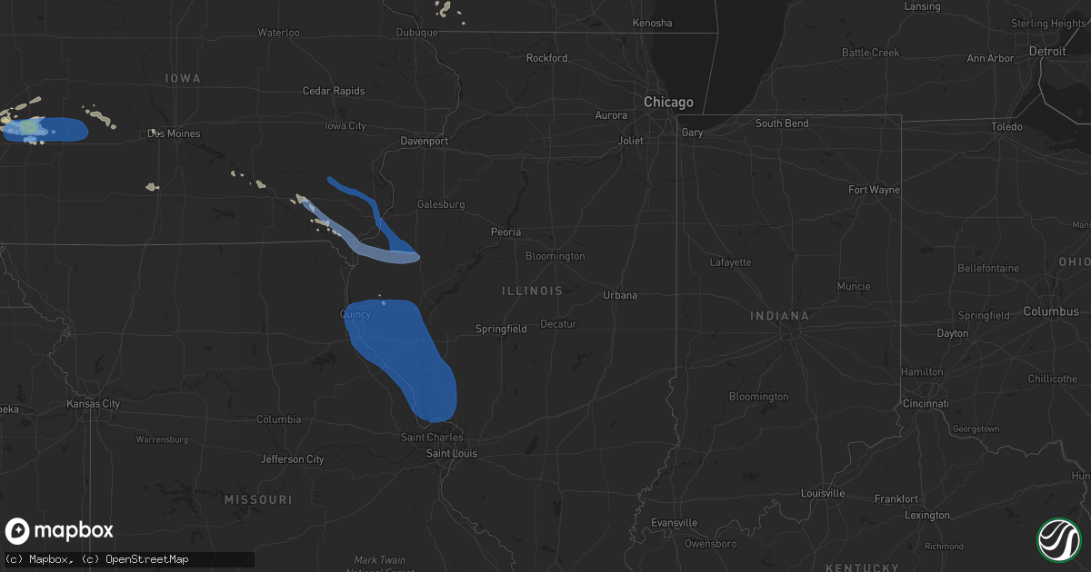
Hail Map in Illinois on July 17, 2019
Get this storm
July 17 map
$229
one time, instant access
Download today. No call, no setup
Keep the $229
Bought the map and want the full workflow? Apply the entire $229 to a subscription within 7 days. None of it is wasted.
Every map, not just this one
This buys you this map. Subscription and you get every map we run, in the markets you choose from a few cities to whole states to nationwide. Plus real-time alerts the moment a storm fires.
Contact data
Name, contact info, occupancy, even credit band for addresses in the footprint. You go from where it hit to who to call.
Become the source they trust
Unlimited branding weather history reports on demand. You already have the documented answer ready for the property owner, and you are the one who showed up with it.
Property data and RoofTrace estimates
Pull up any address you have got, its value and the exact code rules for that jurisdiction, straight from One Click Code. Then RoofTrace estimates the squares, pitch, and roof value, priced the way you price.
Storm reports in Illinois
Illinois
| Date | Description |
|---|---|
| 07/17/20196:40 PM CDT | Power lines down along south market street in waterloo. Time estimated from radar. |
| 07/17/20196:12 PM CDT | Minor roof damage to a house. Time estimated from radar. |
| 07/17/20196:10 PM CDT | Tree limbs blown down. Shingles blown of several homes. |
| 07/17/20194:34 PM CDT | Tree down north of town near 41 and the railroad tracks. |
| 07/17/20194:32 PM CDT | A local report indicates 1.00 inch wind near BEARDSTOWN |
| 07/17/20194:25 PM CDT | Trees down... Estimated 60-70 mph wind gusts. |
| 07/17/20194:20 PM CDT | A local report indicates 60 MPH wind near 1 SE MACOMB |
| 07/17/20194:19 PM CDT | Few downed limbs. |
| 07/17/20194:14 PM CDT | Barn roof destroyed. Windows blown out of a tractor. Shingles ripped off a roof. Time estimated from radar. |
| 07/17/20194:12 PM CDT | Corrects previous tstm wnd dmg report from 3 nnw perry. Minor roof damage to a house. Time estimated from radar. |
| 07/17/20194:04 PM CDT | Delayed report and time estimated from radar. Corn flattened in a field. |
| 07/17/20193:59 PM CDT | Delayed report with time estimated from radar. 2 20 inch plus diameter trees down. Corn flattened on the south side of state route 9 and continuing broadly south for mi |
| 07/17/20193:45 PM CDT | Large tree snapped and fell onto a garage. |
| 07/17/20193:07 PM CDT | Delayed report. Time estimated from radar. Numerous trees and power lines down in nauvoo. Mobile home destroyed. |
| 07/17/20193:05 PM CDT | 2-inch trees down in several spots nearby. |
| 07/17/20193:06 AM CDT | At 806 PM CDT, severe thunderstorms were located along a line extending from 6 miles southwest of Helm to near Thompsonville, moving east at 35 mph. Law enforcement reports numerous trees and power lines downed throughout Jefferson county with these storms, so take cover now! HAZARD...60 mph wind gusts. SOURCE...Law enforcement. IMPACT...Expect damage to roofs, siding, and trees. Locations impacted include... Carmi, Fairfield, Mcleansboro, Norris City, Wayne City, Cisne, Enfield, Dahlgren, Jeffersonville, Sims, Mill Shoals, Broughton, Springerton, Mount Erie, Keenes, Johnsonville, Golden Gate, Macedonia, Belle Prairie City and Burnt Prairie.This includes Interstate 64 in Illinois between Mile Markers 92 and121. |
| 07/17/20192:37 AM CDT | At 736 PM CDT, a severe thunderstorm was located over Sesser, or near Rend Lake Area, moving east at 40 mph. A spotter reported trees bending with estimated 45 to 50 mph winds as the storm was hitting Sesser, and the storm is strengthening. HAZARD...60 mph wind gusts and penny size hail. SOURCE...Trained weather spotters. IMPACT...Expect damage to roofs, siding, and trees. Locations impacted include... Benton, Christopher, Rend Lake Area, Mount Vernon, Sesser, Woodlawn, Bluford, Valier, West City, Ina, North City, Dix, Waltonville, Bonnie, Belle Rive, Ewing and Nason.This includes the following highways... Interstate 57 in Illinois between Mile Markers 72 and 105. Interstate 64 in Illinois between Mile Markers 63 and 90. |
| 07/17/20191:37 AM CDT | At 637 PM CDT, severe thunderstorms were located along a line extending from near New Athens to near De Soto, moving south at 35 mph. HAZARD...60 mph wind gusts. SOURCE...Radar indicated. IMPACT...Expect damage to roofs, siding, and trees. Locations impacted include... Arnold, Festus, Waterloo, Columbia, De Soto, Pevely, Crystal City, Red Bud, Herculaneum, Hillsboro, Barnhart, Cedar Hill, Oakville, Antonia, Mehlville, Lemay, Valmeyer, Olympian Village, Cedar Hill Lakes and Fountain.This includes Interstate 55 in Missouri between exits 170 and 191. This also includes Washington State Park, Mastodon Historic Site,Sandy Creek Covered Bridge Historic Site, and Gov. Dunklin's GraveHistoric Site. |
| 07/17/20191:10 AM CDT | At 610 PM CDT, severe thunderstorms were located along a line extending from near Perryville to Bollinger Mill State Historic Site, moving east at 35 mph. HAZARD...60 mph wind gusts and penny size hail. SOURCE...Radar indicated. IMPACT...Expect damage to roofs, siding, and trees. Locations impacted include... Cape Girardeau, Jackson, Chester, Perryville, Bollinger Mill State Historic Site, Trail Of Tears State Park, Altenburg, Millersville, Burfordville, Daisy, Frohna, Oak Ridge, Pocahontas, Longtown, Old Appleton and Lithium.This includes Interstate 55 between Mile Markers 100 and 131. |
| 07/17/20191:01 AM CDT | At 601 PM CDT, severe thunderstorms were located along a line extending from Overland to near Beaufort, moving southeast at 65 mph. HAZARD...60 mph wind gusts. SOURCE...Radar indicated. IMPACT...Expect damage to roofs, siding, and trees. Locations impacted include... St. Louis, O'Fallon, St. Charles, St. Peters, Chesterfield, Wildwood, University City, Ballwin, Kirkwood, Maryland Heights, Webster Groves, Arnold, Manchester, Creve Coeur, Overland, Clayton, Washington, Crestwood, Festus and Dardenne Prairie.This includes the following highways... Interstate 44 in Missouri between exits 247 and 277. Interstate 55 in Missouri between exits 170 and 191. Interstate 70 in Missouri between exits 222 and 231.This also includes Babler Memorial State Park, Washington State Park,Route 66 State Park, Castlewood State Park, Mastodon Historic Site,Sandy Creek Covered Bridge Historic Site, Gov. Dunklin's GraveHistoric Site, First Missouri State Capitol Historic Site, andRobertsville State Park. |
| 07/16/201911:29 PM CDT | At 428 PM CDT, severe thunderstorms were located along a line extending from near Little Swan Lake to near Adair to Vermont, moving southeast at 25 mph. HAZARD...60 mph wind gusts. SOURCE...Trained weather spotters. IMPACT...Expect damage to roofs, siding, and trees. Locations impacted include... Macomb, Bushnell, Industry, Good Hope, Prairie City, Bardolph, Sciota, Western Illinois University, Adair, Little Swan Lake, New Philadelphia, Walnut Grove, Pennington Point, Macomb Municipal Airport, Doddsville, Scottsburg, Spring Lake, Swan Creek, Youngstown and Prairie City Airport. |
| 07/16/201911:14 PM CDT | At 414 PM CDT, severe thunderstorms were located along a line extending from near Rushville to 6 miles northwest of Naples to 7 miles northeast of Frankford, moving southeast at 45 mph. HAZARD...60 mph wind gusts and quarter size hail. SOURCE...Radar indicated. IMPACT...Hail damage to vehicles is expected. Expect wind damage to roofs, siding, and trees. Locations impacted include... Jacksonville, Beardstown, Virginia, Winchester, Alexander, Ashland, Waverly, Meredosia, Bluff Springs, Bluffs, Franklin, Murrayville, Woodson, Chapin, Arenzville, Manchester, Alsey, Naples, Exeter and Literberry.This includes Interstate 72 between mile markers 43 and 79. |
| 07/16/201911:11 PM CDT | At 411 PM CDT, severe thunderstorms were located along a line extending from 6 miles east of Mount Sterling to near Griggsville to Spaulding, moving southeast at 55 mph. HAZARD...60 mph wind gusts and penny size hail. SOURCE...Radar indicated. IMPACT...Expect damage to roofs, siding, and trees. Locations impacted include... Hannibal, Bowling Green, Pittsfield, Louisiana, White Hall, Carrollton, Mount Sterling, Roodhouse, Barry, Griggsville, Greenfield, New London, Hardin, Pleasant Hill, Atlas, Eolia, Clarksville, Athensville, Frankford and Pike.This includes Interstate 72 between exits 10 and 35. |
| 07/16/201910:36 PM CDT | At 336 PM CDT, severe thunderstorms were located along a line extending from near Bowen to near Mendon to near Quincy, moving southeast at 40 mph. HAZARD...60 mph wind gusts and penny size hail. SOURCE...Radar indicated. IMPACT...Expect damage to roofs, siding, and trees. Locations impacted include... Quincy, Pittsfield, Quincy Regional Airport, Mount Sterling, Barry, Griggsville, Camp Point, Payson, Mendon, Clayton, Golden, Fall Creek, Beverly, Buckhorn, Adams, La Grange, Kingston, Burton, Liberty and Versailles.This includes the following highways... Interstate 172 between exits 2 and 19. Interstate 72 between exits 4 and 35.This also includes Siloam Springs State Park. |
| 07/16/201910:32 PM CDT | At 332 PM CDT, severe thunderstorms were located along a line extending from near Biggsville to near Colmar to near Quincy, moving southeast at 45 mph. HAZARD...60 mph wind gusts and quarter size hail. SOURCE...Radar indicated. IMPACT...Hail damage to vehicles is expected. Expect wind damage to roofs, siding, and trees. Locations impacted include... Beardstown, Rushville, Lewistown, Cuba, Astoria, Avon, Vermont, St. David, Ipava, Littleton, Browning, Table Grove, Dunfermline, Bernadotte, Smithfield, Bryant, Frederick, Huntsville, Marietta and Ellisville. |
| 07/16/20199:58 PM CDT | At 258 PM CDT, severe thunderstorms were located along a line extending from near Fort Madison to near St. Francisville to 8 miles south of Kahoka, moving southeast at 45 mph. HAZARD...60 mph wind gusts and penny size hail. SOURCE...Radar indicated. IMPACT...Expect damage to roofs, siding, and trees. Locations impacted include... Canton, La Grange, La Belle, Lewistown, Ewing, Maywood, Steffenville, Ursa, Lima, Monticello and Meyer.This also includes Wakonda State Park. |
| 07/16/20198:29 PM CDT | Several trees down along highway 242 at county road 1650 north. Time estimated. |
| 07/16/20198:04 PM CDT | Numerous reports of tree limbs down and damage to power lines across jefferson county. |
| 07/16/20197:55 PM CDT | Tree limbs down on cars and power line damage. Time estimated. |
All States Impacted by Hail Map on July 17, 2019
Cities Impacted by Hail Map on July 17, 2019
- Ottumwa, IA
- Eddyville, IA
- Alberta, MN
- Eldon, IA
- Batavia, IA
- Linton, ND
- Alpine, TX
- Dunlap, IA
- Woodbine, IA
- Marathon, TX
- Fennimore, WI
- Eastman, WI
- Avoca, IA
- Shelby, IA
- Saint Anthony, ND
- Gillette, WY
- Sundance, WY
- Beulah, WY
- Spearfish, SD
- Aladdin, WY
- Granada, MN
- Swea City, IA
- Elmore, MN
- Blue Earth, MN
- Ledyard, IA
- Bronson, FL
- Hillsboro, IA
- Keosauqua, IA
- Bonaparte, IA
- Stockport, IA
- Hebron, ND
- Rudd, IA
- Osage, IA
- Nora Springs, IA
- Rozet, WY
- Manly, IA
- Mason City, IA
- Fort Pierre, SD
- Pierre, SD
- Moorcroft, WY
- Belle Plaine, MN
- Jordan, MN
- New Prague, MN
- Briggsdale, CO
- Pine River, MN
- Lusk, WY
- Lance Creek, WY
- Belfield, ND
- Dickinson, ND
- Northfield, MN
- Solen, ND
- Mandan, ND
- Bottineau, ND
- Osceola, IA
- Murray, IA
- Truro, IA
- Glenwood, MN
- Lakeville, MN
- Prior Lake, MN
- Savage, MN
- Burnsville, MN
- New Leipzig, ND
- Flasher, ND
- Long Valley, SD
- Weldona, CO
- Orchard, CO
- Wanblee, SD
- Elk Horn, IA
- Exira, IA
- Audubon, IA
- Pine Ridge, SD
- Kyle, SD
- Warrenton, MO
- Foristell, MO
- Wright City, MO
- Marthasville, MO
- Shields, ND
- Carson, ND
- Woodman, WI
- Boscobel, WI
- Bismarck, ND
- Maxbass, ND
- Newburg, ND
- Upham, ND
- Sturgis, SD
- Piedmont, SD
- Deadwood, SD
- Winter Haven, FL
- Polk City, FL
- Lakeland, FL
- Auburndale, FL
- Richardton, ND
- Gladstone, ND
- Taylor, ND
- Sherwood, ND
- Harrison, NE
- Whitney, NE
- Crawford, NE
- Chadron, NE
- Mott, ND
- Hayes, VA
- Washington, MO
- Wibaux, MT
- Starbuck, MN
- Benson, MN
- Platteville, WI
- Belmont, WI
- Farmington, MN
- Persia, IA
- Portsmouth, IA
- Harlan, IA
- Kirkman, IA
- Panama, IA
- New Virginia, IA
- Kadoka, SD
- Woden, IA
- Titonka, IA
- Moville, IA
- Saint Paul, MN
- Watford City, ND
- Arnegard, ND
- Fort Yates, ND
- Selfridge, ND
- Earling, IA
- Defiance, IA
- Sioux City, IA
- Elgin, ND
- Alpine, NJ
- Norwood, NJ
- Bayard, IA
- Fort Meade, SD
- Whitewood, SD
- Stitzer, WI
- Big Falls, MN
- Effie, MN
- Coon Rapids, IA
- Livingston, WI
- New Salem, ND
- Savage, MT
- Laddonia, MO
- Martinsburg, MO
- Walnut, IA
- Dunseith, ND
- Kramer, ND
- Graettinger, IA
- Clontarf, MN
- Hancock, MN
- Hastings, MN
- Rosemount, MN
- Medora, ND
- West Des Moines, IA
- Carlsbad, NM
- Webster, FL
- Beach, ND
- Mount Hope, WI
- Elko New Market, MN
- Anthon, IA
- Danbury, IA
- Lawton, IA
- Morriston, FL
- Williston, FL
- Farmington, IA
- Donnellson, IA
- Birmingham, IA
- Manilla, IA
- Emmons, MN
- Kiester, MN
- Scarville, IA
- Backus, MN
- Brooklyn, WI
- Evansville, WI
- Midland, SD
- Karval, CO
- Hugo, CO
- Irwin, IA
- Nokesville, VA
- Fairfield, IA
- Catlett, VA
- Fallon, MT
- Lonsdale, MN
- Webster, MN
- Montgomery, MN
- North Sioux City, SD
- Morris, MN
- Orchard, IA
- Altoona, FL
- Burke, SD
- Panora, IA
- Marfa, TX
- Brooten, MN
- Crane, MT
- Bussey, IA
- Inver Grove Heights, MN
- Atwood, KS
- Strasburg, ND
- Camp Point, IL
- Northome, MN
- Hildreth, NE
- Thompson, IA
- Bristow, VA
- Sentinel Butte, ND
- Mentone, TX
- Lancaster, WI
- Mineral Point, WI
- Cuba City, WI
- Darlington, WI
- Ellis, KS
- Yonkers, NY
- Libertyville, IA
- Fenton, IA
- Ringsted, IA
- Bancroft, IA
- Lone Rock, IA
- Logan, IA
- Catharine, KS
- Glendive, MT
- Wauzeka, WI
- Prairie Du Chien, WI
- Steuben, WI
- Staples, MN
- Gratiot, WI
- Clear Lake, IA
- Plymouth, IA
- Rock Falls, IA
- Floyd, IA
- Rewey, WI
- Hanlontown, IA
- Joice, IA
- Cylinder, IA
- Guthrie Center, IA
- Brooksville, FL
- Kensett, IA
- Waukee, IA
- Urbandale, IA
- Clive, IA
- Bowling Green, FL
- Souris, ND
- Grover, CO
- Kabetogama, MN
- International Falls, MN
- Littlefork, MN
- Orr, MN
- Lewes, DE
- Georgetown, DE
- Milton, DE
- Harbeson, DE
- Carman, IL
- West Burlington, IA
- Morning Sun, IA
- Colchester, IL
- Burlington, IA
- Winfield, IA
- Blandinsville, IL
- Yarmouth, IA
- Wayland, IA
- Sperry, IA
- Brighton, IA
- Mount Union, IA
- Lomax, IL
- Macomb, IL
- Mount Pleasant, IA
- La Harpe, IL
- Dallas City, IL
- Washington, IA
- Sciota, IL
- Mediapolis, IA
- Montrose, IA
- Fort Madison, IA
- Niota, IL
- Keokuk, IA
- West Point, IA
- Nauvoo, IL
- Hamilton, IL
- Carthage, IL
- Tennessee, IL
- Perry, IL
- Eldred, IL
- Wrights, IL
- Hannibal, MO
- Dow, IL
- Jerseyville, IL
- Baylis, IL
- Batchtown, IL
- Medora, IL
- Rockbridge, IL
- Kinderhook, IL
- Elsberry, MO
- Chambersburg, IL
- Carrollton, IL
- Kane, IL
- Saint Charles, MO
- Pleasant Hill, IL
- Payson, IL
- Palmyra, MO
- Meredosia, IL
- Hardin, IL
- Pearl, IL
- Clarksville, MO
- New London, MO
- Foley, MO
- Mount Sterling, IL
- Kampsville, IL
- Patterson, IL
- Versailles, IL
- Brighton, IL
- Griggsville, IL
- Quincy, IL
- Hamburg, IL
- Plainville, IL
- Taylor, MO
- Greenfield, IL
- Coatsburg, IL
- Fieldon, IL
- Roodhouse, IL
- Hillview, IL
- Mendon, IL
- New Canton, IL
- Hull, IL
- Louisiana, MO
- Winchester, IL
- Timewell, IL
- Frankford, MO
- Milton, IL
- Nebo, IL
- Pittsfield, IL
- Annada, MO
- Grafton, IL
- White Hall, IL
- Brussels, IL
- Barry, IL
- Elsah, IL
- Paloma, IL
- Clayton, IL
- Maywood, MO
- Portage Des Sioux, MO
- Fowler, IL
- Ashburn, MO
- Godfrey, IL
- Bluffs, IL
- Rockport, IL
- Liberty, IL
- New Salem, IL
- Lexington, VA
- Douglas, WY
- Edgemont, SD
- Harrold, SD
- Sioux Center, IA
- Alton, IA
- Hospers, IA
- Rock Valley, IA
- Ireton, IA
- Hull, IA
- Alcester, SD
- Boyden, IA
- Sheldon, IA
- Hudson, SD
- Orange City, IA
- Maurice, IA
- Hawarden, IA
- Atlantic, IA
- Kimballton, IA
- Adair, IA
- Anita, IA
- Hamlin, IA
- Marne, IA
- Brayton, IA
- Douglassville, PA
- Lancaster, PA
- Ronks, PA
- Gordonville, PA
- Terre Hill, PA
- Manchester, MD
- Narvon, PA
- Hanover, PA
- Felton, PA
- Smoketown, PA
- Kinzers, PA
- Morgantown, PA
- Glen Rock, PA
- Dallastown, PA
- Elverson, PA
- Shrewsbury, PA
- Spring Grove, PA
- Seven Valleys, PA
- New Freedom, PA
- Willow Street, PA
- East Earl, PA
- Intercourse, PA
- York, PA
- Pottstown, PA
- Boyertown, PA
- Wrightsville, PA
- Airville, PA
- Windsor, PA
- Pequea, PA
- Westminster, MD
- Bird In Hand, PA
- Brogue, PA
- Washington Boro, PA
- Conestoga, PA
- Birdsboro, PA
- Leola, PA
- Red Lion, PA
- Glenville, PA
- Stewartstown, PA
- Strasburg, PA
- Gap, PA
- Mohnton, PA
- Millersville, PA
- New Holland, PA
- Honey Brook, PA
- Paradise, PA
- New Providence, PA
- Parkesburg, PA
- Quarryville, PA
- Coatesville, PA
- Christiana, PA
- Downingtown, PA
- Thorndale, PA
- West Chester, PA
- Kennett Square, PA
- Gilbertville, MA
- Barre, MA
- Petersham, MA
- Hardwick, MA
- Hubbardston, MA
- Westminster, MA
- Lee, MA
- West Stockbridge, MA
- Lenox Dale, MA
- Becket, MA
- Stockbridge, MA
- Richmond, MA
- Lenox, MA
- Old Chatham, NY
- East Chatham, NY
- Nassau, NY
- Canaan, NY
- Malden Bridge, NY
- Valatie, NY
- Wingate, MD
- Crocheron, MD
- Crapo, MD
- Nanticoke, MD
- Hebron, MD
- Bivalve, MD
- Quantico, MD
- Tyaskin, MD
- Eden, MD
- Vienna, MD
- Salisbury, MD
- Toddville, MD
- Fruitland, MD
- Sunburg, MN
- Murdock, MN
- Dupree, SD
- Gettysburg, SD
- Eagle Butte, SD
- Selby, SD
- Charlottesville, VA
- Stanardsville, VA
- Free Union, VA
- Dyke, VA
- Ruckersville, VA
- Earlysville, VA
- Crozet, VA
- Catharpin, VA
- Clifton, VA
- Fairfax, VA
- Haymarket, VA
- Manassas, VA
- Chantilly, VA
- Centreville, VA
- Gainesville, VA
- Warrenton, VA
- Silver Spring, MD
- Hyattsville, MD
- Bethesda, MD
- Cabin John, MD
- Kensington, MD
- Takoma Park, MD
- Chevy Chase, MD
- Glen Echo, MD
- Washington, DC
- Alexandria, VA
- Fort Belvoir, VA
- Dumfries, VA
- Springfield, VA
- Occoquan, VA
- Woodbridge, VA
- Lorton, VA
- Ashburn, VA
- Perryville, MD
- Barnesville, MD
- North East, MD
- Fork, MD
- Woodbine, MD
- Reisterstown, MD
- Leesburg, VA
- Clarksville, MD
- Abingdon, MD
- Perryman, MD
- Fallston, MD
- Derwood, MD
- Forest Hill, MD
- Darlington, MD
- Street, MD
- Olney, MD
- Kingsville, MD
- Nottingham, MD
- Upper Falls, MD
- Havre De Grace, MD
- Boyds, MD
- Aberdeen, MD
- Randallstown, MD
- Clarksburg, MD
- Joppa, MD
- Sparks Glencoe, MD
- Colora, MD
- Phoenix, MD
- Poolesville, MD
- Aberdeen Proving Ground, MD
- Montgomery Village, MD
- Beallsville, MD
- Hunt Valley, MD
- Cooksville, MD
- Parkville, MD
- Conowingo, MD
- Lutherville Timonium, MD
- Pikesville, MD
- Adamstown, MD
- Hydes, MD
- Cockeysville, MD
- Belcamp, MD
- Marriottsville, MD
- Perry Point, MD
- Ellicott City, MD
- Churchville, MD
- Glenwood, MD
- Damascus, MD
- Jarrettsville, MD
- Baltimore, MD
- Windsor Mill, MD
- Mount Airy, MD
- Bel Air, MD
- Owings Mills, MD
- West Friendship, MD
- Edgewood, MD
- Perry Hall, MD
- Dayton, MD
- Dickerson, MD
- Gaithersburg, MD
- Glen Arm, MD
- Glenelg, MD
- Germantown, MD
- Baldwin, MD
- Woodstock, MD
- Towson, MD
- White Marsh, MD
- Sykesville, MD
- Stevenson, MD
- Sterling, VA
- Monkton, MD
- Gwynn Oak, MD
- Port Deposit, MD
- Rising Sun, MD
- Brookeville, MD


