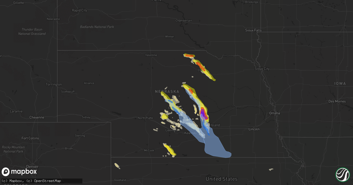
Hail Map in Nebraska on July 16, 2022
Get this storm
July 16 map
$229
one time, instant access
Download today. No call, no setup
Keep the $229
Bought the map and want the full workflow? Apply the entire $229 to a subscription within 7 days. None of it is wasted.
Every map, not just this one
This buys you this map. Subscription and you get every map we run, in the markets you choose from a few cities to whole states to nationwide. Plus real-time alerts the moment a storm fires.
Contact data
Name, contact info, occupancy, even credit band for addresses in the footprint. You go from where it hit to who to call.
Become the source they trust
Unlimited branding weather history reports on demand. You already have the documented answer ready for the property owner, and you are the one who showed up with it.
Property data and RoofTrace estimates
Pull up any address you have got, its value and the exact code rules for that jurisdiction, straight from One Click Code. Then RoofTrace estimates the squares, pitch, and roof value, priced the way you price.
Storm reports in Nebraska
Nebraska
| Date | Description |
|---|---|
| 07/16/20226:54 PM CDT | A local report indicates 74 MPH wind near ORD AIRPORT |
| 07/16/20226:51 PM CDT | A local report indicates 59 MPH wind near 3 NNW ORD |
| 07/16/20226:35 PM CDT | Winds estimated 50 to 60 mph with hail |
| 07/16/20226:30 PM CDT | A local report indicates 1.75 inch wind near 7 ENE BURWELL |
| 07/16/20226:25 PM CDT | Audience member said trees are blocking streets in town. |
| 07/16/20226:15 PM CDT | A local report indicates 1.25 inch wind near 9 N BURWELL |
| 07/16/20225:50 PM CDT | A local report indicates 1.00 inch wind near 13 N BURWELL |
| 07/16/20222:42 PM CDT | Delayed report of lots of tree damage. |
| 07/16/20222:00 PM CDT | 8-12 inch tree branches down. |
| 07/16/20221:54 PM CDT | A local report indicates 1.00 inch wind near 5 E ONEILL |
| 07/16/20226:50 AM CDT | At 1150 AM CDT, a severe thunderstorm was located 8 miles southwest of Naper, or 23 miles west of Spencer, moving east at 20 mph. HAZARD...60 mph wind gusts and half dollar size hail. SOURCE...Radar indicated. IMPACT...Hail damage to vehicles is expected. Expect wind damage to roofs, siding, and trees. Locations impacted include... Butte, Dustin, Anoka, Parshall Bridge State Wildlife Management Area and Hull Lake State Wildlife Management Area.This includes Highway 12 between mile markers 103 and 120. |
| 07/16/20224:41 AM CDT | At 940 PM CDT, severe thunderstorms were located along a line extending from near Harvard to near Deweese to near Blue Hill, moving southeast at 50 mph. HAZARD...60 mph wind gusts and penny size hail. SOURCE...Radar indicated. IMPACT...Expect damage to roofs, siding, and trees. Severe thunderstorms will be near... Fairfield, Lawrence, Deweese and Rosemont around 945 PM CDT. Red Cloud and Cowles around 950 PM CDT. Nelson and Guide Rock around 1000 PM CDT.Other locations in the path of these severe thunderstorms includeEdgar, Nora, Bostwick, Superior, Ruskin, Ong, Davenport, Hardy andOak. |
| 07/16/20224:10 AM CDT | At 909 PM CDT, a severe thunderstorm was located near Prosser, or 9 miles northwest of Hastings, moving southeast at 40 mph. THIS IS A DESTRUCTIVE STORM FOR Hastings. HAZARD...80 mph wind gusts and quarter size hail. SOURCE...Trained weather spotters. IMPACT...Flying debris will be dangerous to those caught without shelter. Mobile homes will be heavily damaged. Expect considerable damage to roofs, windows, and vehicles. Extensive tree damage and power outages are likely. This severe thunderstorm will be near... Hansen around 915 PM CDT. Hastings and Juniata around 920 PM CDT.Other locations in the path of this severe thunderstorm includeGlenvil, Ayr and Deweese. |
| 07/16/20223:59 AM CDT | At 858 PM CDT, severe thunderstorms were located along a line extending from 7 miles south of Gibbon to near Heartwell to near Minden to 7 miles northeast of Axtell to 7 miles southwest of Kearney, moving southeast at 45 mph. HAZARD...70 mph wind gusts and quarter size hail. SOURCE...Mesonet observation of 64 mph at Kearney. IMPACT...Hail damage to vehicles is expected. Expect considerable tree damage. Wind damage is also likely to mobile homes, roofs, and outbuildings. Severe thunderstorms will be near... Minden and Heartwell around 905 PM CDT. Norman around 910 PM CDT.Other locations in the path of these severe thunderstorms includeHolstein, Hildreth, Upland, Campbell and Bladen. |
| 07/16/20223:51 AM CDT | At 851 PM CDT, a severe thunderstorm was located over Cairo, or 12 miles northwest of Grand Island, moving south at 35 mph. HAZARD...Golf ball size hail and 70 mph wind gusts. SOURCE...Radar indicated. IMPACT...People and animals outdoors will be injured. Expect hail damage to roofs, siding, windows, and vehicles. Expect considerable tree damage. Wind damage is also likely to mobile homes, roofs, and outbuildings. This severe thunderstorm will be near... Wood River and Alda around 910 PM CDT.Other locations in the path of this severe thunderstorm includeDoniphan, Hastings, Prosser and Hansen.This includes Interstate 80 between mile markers 293 and 317. |
| 07/16/20223:44 AM CDT | At 844 PM CDT, a severe thunderstorm was located over Eddyville, or 15 miles north of Lexington, moving southeast at 30 mph. HAZARD...60 mph wind gusts and quarter size hail. SOURCE...Radar indicated. IMPACT...Hail damage to vehicles is expected. Expect wind damage to roofs, siding, and trees. This severe thunderstorm will be near... Sumner around 900 PM CDT.This includes Interstate 80 near mile marker 254. |
| 07/16/20223:33 AM CDT | At 833 PM CDT, severe thunderstorms were located along a line extending from Ravenna to 8 miles southeast of Pleasanton to near Riverdale to near Miller, moving southeast at 45 mph. HAZARD...70 mph wind gusts and quarter size hail. SOURCE...Radar indicated. IMPACT...Hail damage to vehicles is expected. Expect considerable tree damage. Wind damage is also likely to mobile homes, roofs, and outbuildings. Severe thunderstorms will be near... Ravenna and Poole around 840 PM CDT. Elm Creek around 845 PM CDT. Gibbon around 850 PM CDT.Other locations in the path of these severe thunderstorms includeShelton, Odessa and Kearney.This includes Interstate 80 between mile markers 255 and 292. |
| 07/16/20223:07 AM CDT | At 806 PM CDT, severe thunderstorms were located along a line extending from near Loup City to near Ashton to near Cushing, moving south at 25 mph. HAZARD...60 mph wind gusts and half dollar size hail. SOURCE...Emergency management reported 60 mph winds at Sherman Reservoir. IMPACT...Hail damage to vehicles is expected. Expect wind damage to roofs, siding, and trees. Severe thunderstorms will be near... Elba around 810 PM CDT. Cushing around 815 PM CDT. St. Paul and Farwell around 820 PM CDT.Other locations in the path of these severe thunderstorms includeRockville, Dannebrog, Boelus and St. Libory. |
| 07/16/20222:56 AM CDT | At 755 PM CDT, a severe thunderstorm was located 8 miles southwest of Mason City, or 23 miles southeast of Broken Bow, moving southeast at 35 mph. HAZARD...70 mph wind gusts and quarter size hail. SOURCE...Radar indicated. IMPACT...Hail damage to vehicles is expected. Expect considerable tree damage. Wind damage is also likely to mobile homes, roofs, and outbuildings. This severe thunderstorm will be near... Miller around 815 PM CDT.Other locations in the path of this severe thunderstorm includePleasanton, Amherst and Riverdale. |
| 07/16/20222:55 AM CDT | At 755 PM CDT, a severe thunderstorm was located 11 miles southwest of Callaway, or 26 miles southwest of Broken Bow, moving southeast at 10 mph. HAZARD...70 mph wind gusts and ping pong ball size hail. SOURCE...Radar indicated. IMPACT...People and animals outdoors will be injured. Expect hail damage to roofs, siding, windows, and vehicles. Expect considerable tree damage. Wind damage is also likely to mobile homes, roofs, and outbuildings. Locations impacted include... Oconto, Etna, Lodi and Pressey State Wildlife Management Area. |
| 07/16/20222:52 AM CDT | At 752 PM CDT, a severe thunderstorm was located 10 miles southwest of Callaway, or 26 miles southwest of Broken Bow, moving southeast at 15 mph. HAZARD...70 mph wind gusts and quarter size hail. SOURCE...Radar indicated. IMPACT...Hail damage to vehicles is expected. Expect considerable tree damage. Wind damage is also likely to mobile homes, roofs, and outbuildings. This severe thunderstorm will remain over mainly rural areas of northeastern Dawson County. |
| 07/16/20222:40 AM CDT | At 739 PM CDT, a severe thunderstorm was located near Berwyn, or 7 miles southeast of Broken Bow, moving southeast at 35 mph. THIS IS A DESTRUCTIVE STORM FOR BERWYN, ANSLEY AND MASON CITY. HAZARD...90 mph wind gusts and quarter size hail. SOURCE...Public. At 725 PM...90 MPH WIND GUST WAS RECORDED AT BROKEN BOW AIRPORT.. IMPACT...You are in a life-threatening situation. Flying debris may be deadly to those caught without shelter. Mobile homes will be heavily damaged or destroyed. Homes and businesses will have substantial roof and window damage. Expect extensive tree damage and power outages. Locations impacted include... Ansley, Mason City, Berwyn, Buckeye, Block Hill Basin, Burr Oak, Gavin Siding, Intersection of Highway 183 and Cumro Road and Cumro.This includes the following highways... Highway 183 between mile markers 73 and 96. Highway 2 between mile markers 288 and 307. Highway 92 between mile markers 300 and 305. |
| 07/16/20222:34 AM CDT | At 734 PM CDT, a severe thunderstorm was located over Holbrook, or 32 miles west of Holdrege, moving southeast at 20 mph. HAZARD...60 mph wind gusts and half dollar size hail. SOURCE...Radar indicated. IMPACT...Hail damage to vehicles is expected. Expect wind damage to roofs, siding, and trees. This severe thunderstorm will be near... Arapahoe around 740 PM CDT.Other locations in the path of this severe thunderstorm includeEdison, Hendley, Beaver City and Hollinger. |
| 07/16/20222:15 AM CDT | At 715 PM CDT, a severe thunderstorm was located near Callaway, or 23 miles southwest of Broken Bow, moving east at 25 mph. HAZARD...60 mph wind gusts and penny size hail. SOURCE...Radar indicated. IMPACT...Expect damage to roofs, siding, and trees. Locations impacted include... Callaway, Oconto, Lodi and Pressey State Wildlife Management Area. |
| 07/16/20222:15 AM CDT | At 714 PM CDT, a severe thunderstorm was located near North Loup, or 10 miles east of Ord, moving southeast at 25 mph. HAZARD...70 mph wind gusts and half dollar size hail. SOURCE...Mesonet observation of 68 mph at Ord. IMPACT...Hail damage to vehicles is expected. Expect considerable tree damage. Wind damage is also likely to mobile homes, roofs, and outbuildings. This severe thunderstorm will be near... North Loup around 720 PM CDT. Scotia around 730 PM CDT.Other locations in the path of this severe thunderstorm includeCotesfield. |
| 07/16/20222:09 AM CDT | At 709 PM CDT, a severe thunderstorm was located near Victoria Springs State Recreation Area, or 12 miles northwest of Broken Bow, moving southeast at 30 mph. THIS IS A DESTRUCTIVE STORM FOR MERNA AND BROKEN BOW. HAZARD...90 mph wind gusts. SOURCE...Law enforcement. IMPACT...You are in a life-threatening situation. Flying debris may be deadly to those caught without shelter. Mobile homes will be heavily damaged or destroyed. Homes and businesses will have substantial roof and window damage. Expect extensive tree damage and power outages. Locations impacted include... Broken Bow, Merna, Berwyn and Victoria Springs State Recreation Area.This includes the following highways... Highway 2 between mile markers 260 and 288. Highway 92 between mile markers 269 and 273. |
| 07/16/20221:28 AM CDT | At 628 PM CDT, severe thunderstorms were located along a line extending from 11 miles east of Brewster to 6 miles southwest of Dunning, moving southeast at 20 mph. HAZARD...70 mph wind gusts and penny size hail. SOURCE...Public. IMPACT...Expect considerable tree damage. Damage is likely to mobile homes, roofs, and outbuildings. Locations impacted include... Taylor, Sargent, Merna, Anselmo, Victoria Springs State Recreation Area, Lillian, Milburn, Milburn Diversion Dam State Wildlife Management Area, Round Valley, Almeria Meadow State Wildlife Management Area, Walworth, Linscott, Big Oak Canyon, Almeria, Divide Hill and Gates.This includes the following highways... Highway 183 between mile markers 108 and 127. Highway 2 between mile markers 239 and 273. Highway 92 between mile markers 259 and 273. |
| 07/16/20221:21 AM CDT | At 620 PM CDT, a severe thunderstorm was located near Burwell, moving southeast at 25 mph. HAZARD...60 mph wind gusts and half dollar size hail. SOURCE...Radar indicated. IMPACT...Hail damage to vehicles is expected. Expect wind damage to roofs, siding, and trees. This severe thunderstorm will be near... Fort Hartsuff State Park around 640 PM CDT.Other locations in the path of this severe thunderstorm includeElyria, Ord and North Loup. |
| 07/16/20221:16 AM CDT | At 615 PM CDT, a severe thunderstorm was located 7 miles northeast of Burwell, moving southeast at 20 mph. HAZARD...60 mph wind gusts and half dollar size hail. SOURCE...Trained weather spotters. IMPACT...Hail damage to vehicles is expected. Expect wind damage to roofs, siding, and trees. Locations impacted include... Burwell, Deverre, Homestead Knolls Campground and Virginia Smith Dam. |
| 07/16/202212:37 AM CDT | At 537 PM CDT, a severe thunderstorm was located 10 miles north of Calamus Reservoir State Recreation Area, or 17 miles north of Burwell, moving east at 15 mph. HAZARD...Ping pong ball size hail and 60 mph wind gusts. SOURCE...Radar indicated. IMPACT...People and animals outdoors will be injured. Expect hail damage to roofs, siding, windows, and vehicles. Expect wind damage to roofs, siding, and trees. Locations impacted include... Deverre, Sunfish Lake, Valley View Flat Campground, Carson Lake and Hannamon Bayou Campground. |
| 07/15/202210:39 PM CDT | A local report indicates 62 MPH wind near 1 SSE DAVENPORT |
| 07/15/202210:04 PM CDT | A local report indicates 67 MPH wind near 1 N NELSON |
| 07/15/202210:01 PM CDT | Tree branches down a long with power outages. |
| 07/15/20229:49 PM CDT | Trees down in fairfield. |
| 07/15/20229:49 PM CDT | Trees down in fairfield and power is out also. |
| 07/15/20229:49 PM CDT | Tree branches down and power is out in town. |
| 07/15/20229:46 PM CDT | A local report indicates 58 MPH wind near 2 N HASTINGS |
| 07/15/20229:37 PM CDT | 60-70 mph estimated. |
| 07/15/20229:29 PM CDT | At 228 PM CDT, a severe thunderstorm was located over Ewing, or 17 miles northwest of Neligh, moving southeast at 30 mph. HAZARD...60 mph wind gusts and quarter size hail. SOURCE...Radar indicated. IMPACT...Hail damage to vehicles is expected. Expect wind damage to roofs, siding, and trees. This severe thunderstorm will be near... Clearwater around 245 PM CDT.Other locations in the path of this severe thunderstorm includeNeligh and Oakdale. |
| 07/15/20229:26 PM CDT | Tree branches down along with power outage. |
| 07/15/20229:26 PM CDT | Power is out along with tree branches down in town. |
| 07/15/20229:24 PM CDT | A local report indicates 58 MPH wind near HASTINGS AIRPORT |
| 07/15/20228:55 PM CDT | At 153 PM CDT, a severe thunderstorm was located near near O'Neill, moving southeast at 20 mph. HAZARD...60 mph wind gusts and quarter size hail. SOURCE...Radar indicated. IMPACT...Hail damage to vehicles is expected. Expect wind damage to roofs, siding, and trees. Locations impacted include... O'Neill, Ewing, Page, Inman and Knievels Corner. This includes the following highways... Highway 20 between mile markers 309 and 328. Highway 281 between mile markers 172 and 182. |
| 07/15/20228:54 PM CDT | Storm chaser reports 70-80 mph and possible brief tornado 3-4 se of cairo. |
| 07/15/20228:52 PM CDT | Delayed report from saturday evening. Nerain observer commented that they had golf ball size hail. Time estimated from radar. |
| 07/15/20228:51 PM CDT | A local report indicates 64 MPH wind near 3 SW KEARNEY |
| 07/15/20228:23 PM CDT | Follow-up to previous report. The area from farwell to west of dannebrog has a 3-mile wide... 8 to 9 mile long path of widespread crop damage and other structural damag |
| 07/15/20228:23 PM CDT | Nws employee reported hail on the ground in farwell. Time is estimated from radar data. |
| 07/15/20228:14 PM CDT | At 114 PM CDT, a severe thunderstorm was located 8 miles north of O'Neill, moving southeast at 20 mph. HAZARD...60 mph wind gusts and quarter size hail. SOURCE...Radar indicated. IMPACT...Hail damage to vehicles is expected. Expect wind damage to roofs, siding, and trees. Locations impacted include... O'Neill, Page, Inman, Emmet, Opportunity, Midway and Scottville.This includes the following highways... Highway 20 between mile markers 300 and 321. Highway 281 between mile markers 169 and 203. |
| 07/15/20228:11 PM CDT | A local report indicates 1.00 inch wind near ANSLEY |
| 07/15/20228:06 PM CDT | Corrects previous hail report from 5 ene ashton. 7 miles west of elba. Report via facebook. Time estimated from radar. |
| 07/15/20228:04 PM CDT | 60 mph wind gust estimated at sherman reservoir. |
| 07/15/20228:03 PM CDT | Pea size hail also |
| 07/15/20228:00 PM CDT | Report via twitter. |
| 07/15/20227:51 PM CDT | Many tree limbs down in broken bow with several streets blocked. |
| 07/15/20227:36 PM CDT | Roof off two car garage destroyed. Outbuilding destroyed at farmstead 4 w of arapahoe. Half dollar hail also reported with this storm. Delayed report from storm spotter |
| 07/15/20227:36 PM CDT | Corrects previous tstm wnd dmg report from 2 ene holbrook. Roof off two car garage destroyed. Outbuilding destroyed at farmstead 4 w of arapahoe. Half dollar hail also |
| 07/15/20227:35 PM CDT | Large tree limbs down. Estimated 60 mph wind gusts. |
| 07/15/20227:30 PM CDT | Multiple trees downed or uprooted. Gas lines broken. Corn crop stripped. |
| 07/15/20227:28 PM CDT | Report via facebook. Multiple small tree limbs down and electricity out too. |
| 07/15/20227:25 PM CDT | Broken bow airport |
| 07/15/20227:18 PM CDT | A local report indicates 68 MPH wind near 2 N BROKEN BOW |
| 07/15/20227:07 PM CDT | Emergency manager said deputies estimated 90 mph winds along highway 2. Multiple trees are down. |
| 07/15/20227:00 PM CDT | A local report indicates 67 MPH wind near 5 S ANSELMO |
All States Impacted by Hail Map on July 16, 2022
Cities Impacted by Hail Map on July 16, 2022
- Burwell, NE
- Hugo, CO
- Atkinson, NE
- Stuart, NE
- Ellendale, ND
- Loup City, NE
- North Loup, NE
- Ord, NE
- Ashton, NE
- Buffalo Gap, SD
- Hot Springs, SD
- Farnam, NE
- Edgeley, ND
- Verona, ND
- Hazard, NE
- Ravenna, NE
- Rockville, NE
- Oran, MO
- Fredericktown, MO
- Glenallen, MO
- Zalma, MO
- Marble Hill, MO
- Advance, MO
- Greenville, MO
- Marquand, MO
- Montpelier, ND
- Louisburg, NC
- Edgewater, MD
- Davidsonville, MD
- Harwood, MD
- Cozad, NE
- Lexington, NE
- Eddyville, NE
- Fullerton, ND
- Battle Lake, MN
- Clitherall, MN
- Callaway, NE
- Gothenburg, NE
- Morganville, NJ
- Colts Neck, NJ
- Marlboro, NJ
- Holmdel, NJ
- Greensburg, IN
- Hendley, NE
- Beaver City, NE
- Shelbyville, IN
- Wilsons, VA
- Blackstone, VA
- Purdum, NE
- Buffalo Junction, VA
- Clarksville, VA
- Mason City, NE
- Kingman, IN
- Nelson, VA
- Virgilina, VA
- Broken Bow, NE
- Sumner, NE
- Oconto, NE
- Wild Horse, CO
- Karval, CO
- Kit Carson, CO
- Saint Francis, KS
- Bowling Green, IN
- Centerpoint, IN
- Poland, IN
- Overton, NE
- Peridot, AZ
- Colorado Springs, CO
- Brownsburg, IN
- Indianapolis, IN
- Avon, IN
- Sells, AZ
- Clearwater, NE
- La Fontaine, IN
- Wabash, IN
- Vona, CO
- Inman, NE
- Naper, NE
- Oneill, NE
- Page, NE
- Mills, NE
- Ewing, NE
- Carmel, IN
- Zionsville, IN
- Nogales, AZ
- Rio Rico, AZ
- Tumacacori, AZ
- Oxford, NE
- Cambridge, NE
- Holbrook, NE
- Arapahoe, NE
- Stamford, NE
- Eustis, NE
- Edison, NE
- Catonsville, MD
- Ellicott City, MD
- Whiteland, IN
- Needham, IN
- Boggstown, IN
- Franklin, IN
- Fairland, IN
- Westfield, IN
- Greentown, IN
- Windfall, IN
- Sargent, NE
- Eads, CO
- Ramah, CO
- Rush, CO
- Oral, SD
- Lamoure, ND
- Robbins, NC
- Eagle Springs, NC
- Georgetown, MS
- Hazlehurst, MS
- Tonopah, AZ
- Vail, AZ
- Tucson, AZ
- Marion, IN
- Boonville, NC
- Yadkinville, NC
- Hillsboro, IN
- State Road, NC
- Elkin, NC
- Brodnax, VA
- Miami, AZ
- Concord, NC
- Greensboro, NC
- Globe, AZ
- Faber, VA
- Lovingston, VA
- Pleasanton, NE
- Shelton, NE
- Riverdale, NE
- Gibbon, NE
- Kearney, NE
- Boelus, NE
- Farwell, NE
- Elba, NE
- Saint Paul, NE
- Miller, NE
- Cairo, NE
- Dannebrog, NE
- Scotia, NE
- Grand Island, NE
- Wolbach, NE
- Sheridan Lake, CO
- Merna, NE
- Wood River, NE
- Sonoita, AZ
- Henning, MN
- Oxford, NC
- Kenesaw, NE
- Juniata, NE
- Amherst, NE
- Rothsay, MN
- Trinidad, CO
- Green Valley, AZ
- Amado, AZ
- Culpeper, VA
- Litchfield, NE
- Oilville, VA
- Crozier, VA
- Syracuse, KS
- Troy, VA
- Palmyra, VA
- Stuart, VA
- Ansley, NE
- Young, AZ
- San Manuel, AZ
- West Baden Springs, IN
- Shipman, VA
- Nellysford, VA
- Vass, NC
- Dunning, NE
- Saint Libory, NE
- Kenbridge, VA
- Long Island, VA
- Hurt, VA
- Gladys, VA
- Lowry, MN
- Glenwood, MN
- Cicero, IN
- Madison, IN
- Lisbon, ND
- Faison, NC
- Red Oak, VA
- Rougemont, NC
- Westerville, NE
- Alda, NE
- Lakeland, FL
- Mulberry, FL
- Milton, NC
- Alton, VA
- West Terre Haute, IN
- Wilsonville, NE
- Enfield, NC
- Whitakers, NC
- Anselmo, NE
- Rye, CO
- Bumpass, VA
- Manakin Sabot, VA
- Montpelier, VA
- Beaverdam, VA
- Maidens, VA
- Rockville, VA
- Rapidan, VA
- Unionville, VA
- Locust Dale, VA
- Orange, VA
- Moorefield, NE
- Marienthal, KS
- Salisbury, NC
- Spencer, NC
- Lakin, KS
- Doswell, VA
- Ruther Glen, VA
- Arnold, NE
- Brazil, IN
- Corning, KS
- Centralia, KS
- Pelican Rapids, MN
- Chesterfield, SC
- Patrick, SC
- Danville, VA
- Eden, NC
- Thibodaux, LA
- Elm Creek, NE
- Converse, IN
- Chambers, AZ
- Doniphan, NE
- Greeley, NE
- Elyria, NE
- Swayzee, IN
- La Plata, MD
- Charlotte Hall, MD
- Milroy, IN
- Waldron, IN
- Saint Paul, IN
- Des Allemands, LA
- Paradis, LA
- Holly, CO
- Fort Mcdowell, AZ
- Seagrove, NC
- Raeford, NC
- Eure, NC
- Gates, NC
- Mineral, VA
- Gum Spring, VA
- Sandy Hook, VA
- Brandy Station, VA
- Elkwood, VA
- Stevensburg, VA
- Dennison, IL
- Amelia Court House, VA
- Snow Camp, NC
- Burlington, NC
- Jetersville, VA
- Deerfield, KS
- Brady, NE
- Joes, CO
- Clinton, NC
- Spring Grove, PA
- York, PA
- Seven Valleys, PA
- Mitchells, VA
- Rhoadesville, VA
- Greenup, IL
- Casey, IL
- Callaway, VA
- Dundas, VA
- Roxboro, NC
- Roseland, NE
- Heartwell, NE
- Minden, NE
- Holstein, NE
- Ong, NE
- Hastings, NE
- Belleville, KS
- Harvard, NE
- Inland, NE
- Byron, NE
- Deshler, NE
- Superior, NE
- Red Cloud, NE
- Oak, NE
- Fairfield, NE
- Deweese, NE
- Guide Rock, NE
- Trumbull, NE
- Edgar, NE
- Nelson, NE
- Lawrence, NE
- Glenvil, NE
- Davenport, NE
- Ruskin, NE
- Hebron, NE
- Clay Center, NE
- Republic, KS
- Giltner, NE
- Hardy, NE
- Blue Hill, NE
- Ayr, NE
- Saronville, NE
- Chester, NE
- Bladen, NE
- Leopold, MO
- Whitewater, MO
- Sahuarita, AZ
- Saint Hilaire, MN
- Red Lake Falls, MN
- Orchard, NE
- Ericson, NE


