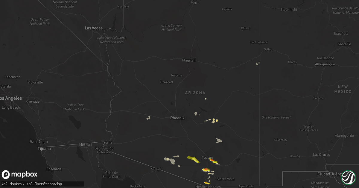
Hail Map in Arizona on July 16, 2022
Get this storm
July 16 map
$229
one time, instant access
Download today. No call, no setup
Keep the $229
Bought the map and want the full workflow? Apply the entire $229 to a subscription within 7 days. None of it is wasted.
Every map, not just this one
This buys you this map. Subscription and you get every map we run, in the markets you choose from a few cities to whole states to nationwide. Plus real-time alerts the moment a storm fires.
Contact data
Name, contact info, occupancy, even credit band for addresses in the footprint. You go from where it hit to who to call.
Become the source they trust
Unlimited branding weather history reports on demand. You already have the documented answer ready for the property owner, and you are the one who showed up with it.
Property data and RoofTrace estimates
Pull up any address you have got, its value and the exact code rules for that jurisdiction, straight from One Click Code. Then RoofTrace estimates the squares, pitch, and roof value, priced the way you price.
Storm reports in Arizona
Arizona
| Date | Description |
|---|---|
| 07/16/20226:52 PM CDT | Public reported 1 inch hail near the intersection of pantano rd and escalante rd. |
| 07/16/20226:49 PM CDT | Photo on twitter at golf links and wilmot. |
| 07/16/20226:47 PM CDT | Near ironwood east of craycroft. |
| 07/16/20226:37 PM CDT | Near drexel and houghton. |
| 07/16/20226:35 PM CDT | Spotter reported measured 1.5 inch hail near the intersection of bilby rd and houghton rd. |
| 07/16/20226:33 PM CDT | Measured 1 inch hail near the i |
| 07/16/20226:33 PM CDT | Measured 1 inch hail near the intersection of houghton rd and poorman rd. |
| 07/16/20226:31 PM CDT | Near bilby and houghton. |
| 07/16/20226:10 PM CDT | A local report indicates 1.00 inch wind near 15 ESE TUCSON |
| 07/16/20224:35 PM CDT | 1.5 inches measured by a caliber measuring tool. |
| 07/16/20224:30 PM CDT | Mostly dime size hail with some quarter size hail for a few minutes. |
| 07/16/20224:20 PM CDT | Reported by trained spotter. |
| 07/16/20226:16 AM CDT | At 1113 PM PDT/1113 PM MST/, a severe thunderstorm was located 9 miles east of Buckskin Mountain Park, or 9 miles east of Parker Dam, moving northwest at 45 mph. HAZARD...60 mph wind gusts. SOURCE...Radar indicated. IMPACT...Expect damage to roofs and trees. Locations impacted include... Lake Havasu City, Parker Dam, Three Dunes Campground, Cattail Cove State Park and Black Meadow Landing Campground. |
| 07/16/20223:32 AM CDT | At 832 PM MST, a severe thunderstorm was located near Liberty, or near Buckeye, moving west at 20 mph. HAZARD...60 mph wind gusts. SOURCE...Radar indicated. IMPACT...Expect damage to roofs, siding, and trees. Locations impacted include... Goodyear, Buckeye, Palo Verde, Perryville, Liberty, Estrella Mountain Ranch, Palo Verde Nuclear Generation Station, Hassayampa and Arlington.This includes the following highways...AZ Interstate 10 between mile markers 100 and 126.AZ Route 85 between mile markers 143 and 154.AZ Route 303 near mile marker 105. |
| 07/16/20223:15 AM CDT | At 814 PM MST, a severe thunderstorm was located near Santa Rosa, or 24 miles north of Sells, moving west at 20 mph. HAZARD...60 mph wind gusts and quarter size hail. SOURCE...Radar indicated. IMPACT...Hail damage to vehicles is expected. Expect wind damage to roofs, siding, and trees. Locations impacted include... Santa Rosa, Covered Wells, Palo Verde Stand, Ak Chin, Mountain Village, San Luis and Santa Rosa School. |
| 07/16/20222:47 AM CDT | At 747 PM MST, a severe thunderstorm was located over Surprise, moving west at 15 mph. HAZARD...60 mph wind gusts. SOURCE...Radar indicated. IMPACT...Expect damage to roofs, siding, and trees. Locations impacted include... Surprise, El Mirage, Youngtown, Wittmann, Sun City West, Sun City, Waddell, Surprise Stadium, White Tank Mountain Park, Beardsley and Vistancia.This includes the following highways...US Highway 60 between mile markers 125 and 148.AZ Route 74 between mile markers 4 and 12.AZ Route 303 between mile markers 112 and 129. |
| 07/16/20222:45 AM CDT | At 744 PM MST, severe thunderstorms were located along a line extending from North Mountain Park to Downtown Phoenix to South Mountain Park, moving west at 20 mph. HAZARD...60 mph wind gusts. SOURCE...Radar indicated. IMPACT...Expect damage to roofs, siding, and trees. Locations impacted include... Phoenix, Glendale, Paradise Valley, Tolleson, Laveen, Piestewa Peak Park, North Mountain Park, South Phoenix, Arizona State Fairgrounds, South Mountain Park, Downtown Phoenix, Metro Center Mall, Sky Harbor Airport and Downtown Glendale.This includes the following highways...AZ Interstate 10 between mile markers 135 and 152.AZ Interstate 17 between mile markers 195 and 209.AZ Route 51 between mile markers 1 and 8. |
| 07/16/20222:43 AM CDT | At 742 PM MST, a severe thunderstorm was located 11 miles south of Hickiwan, or 28 miles southeast of Ajo, moving west at 30 mph. HAZARD...60 mph wind gusts, quarter size hail, and blowing dust. SOURCE...Radar indicated. IMPACT...Hail damage to vehicles is expected. Expect wind damage to roofs, siding, and trees. Locations impacted include... Gu Vo, Hickiwan, Organ Pipe Cactus National Monument, San Simon, Why, Charco 27, Gunsight, Kuakatch and San Simon West. |
| 07/16/20221:57 AM CDT | At 657 PM MST, a severe thunderstorm was located 12 miles east of Pisinemo, or 14 miles northwest of Sells, moving west at 25 mph. HAZARD...60 mph wind gusts and quarter size hail. SOURCE...Radar indicated. IMPACT...Hail damage to vehicles is expected. Expect wind damage to roofs, siding, and trees. Locations impacted include... Pisinemo, Covered Wells, Ali Chugk, San Simon, Santa Cruz, Mountain Village, Kots Kug, Kupk and Papago Farms. |
| 07/16/20221:48 AM CDT | At 647 PM MST, a severe thunderstorm was located near Saddlebrooke, or 8 miles northwest of Catalina, moving southwest at 25 mph. HAZARD...60 mph wind gusts and quarter size hail. SOURCE...Radar indicated. IMPACT...Hail damage to vehicles is expected. Expect wind damage to roofs, siding, and trees. Locations impacted include... Marana, Saddlebrooke, Dove Mountain and Oracle Junction. |
| 07/16/20221:43 AM CDT | At 642 PM MST, a severe thunderstorm was located 14 miles northwest of Three Points, or 23 miles southwest of Marana, moving west at 20 mph. HAZARD...60 mph wind gusts and quarter size hail. SOURCE...Radar indicated. IMPACT...Hail damage to vehicles is expected. Expect wind damage to roofs, siding, and trees. Locations impacted include... Queens Well. |
| 07/16/20221:09 AM CDT | At 608 PM MST, a severe thunderstorm was located 9 miles northwest of Sells, moving west at 25 mph. HAZARD...60 mph wind gusts and quarter size hail. SOURCE...Radar indicated. IMPACT...Hail damage to vehicles is expected. Expect wind damage to roofs, siding, and trees. Locations impacted include... Pisinemo, Gu Oidak, No:ligk, Santa Cruz, Mountain Village and Kupk. |
| 07/16/20221:04 AM CDT | At 604 PM MST, a severe thunderstorm was located over Three Points, or 21 miles northwest of Sahuarita, moving west at 20 mph. HAZARD...60 mph wind gusts and quarter size hail. SOURCE...Radar indicated. IMPACT...Hail damage to vehicles is expected. Expect wind damage to roofs, siding, and trees. Locations impacted include... Three Points, Kitt Peak, Tucson Estates, San Pedro and Pan Tak. |
| 07/16/202212:55 AM CDT | At 555 PM MST, a severe thunderstorm was located near Usery Mountain Park, or near East Mesa, moving southwest at 30 mph. HAZARD...60 mph wind gusts. SOURCE...Radar indicated. IMPACT...Expect damage to roofs, siding, and trees. Locations impacted include... Mesa, Chandler, Gilbert, Apache Junction, Fountain Hills, Gold Canyon, East Mesa, Queen Creek, Granite Reef Dam, Gold Camp, Falcon Field Airport, Lost Dutchman State Park, Goldfield, Usery Mountain Park and San Tan Village Mall.This includes the following highways...US Highway 60 between mile markers 178 and 204.AZ Route 87 between mile markers 166 and 197.AZ Route 202 between mile markers 12 and 47. |
| 07/16/202212:38 AM CDT | At 538 PM MST, a severe thunderstorm was located 10 miles east of Mammoth, moving west at 15 mph. HAZARD...60 mph wind gusts and quarter size hail. SOURCE...Radar indicated. IMPACT...Hail damage to vehicles is expected. Expect wind damage to roofs, siding, and trees. Locations impacted include... Oracle, Mammoth, San Manuel, Dudleyville and Aravaipa Canyon Wilderness. |
| 07/16/202212:36 AM CDT | At 536 PM MST, a severe thunderstorm was located over Canyon Lake, or 11 miles northeast of Apache Junction, moving southwest at 30 mph. HAZARD...60 mph wind gusts. SOURCE...Radar indicated. IMPACT...Expect damage to roofs, siding, and trees. Locations impacted include... Mesa, Apache Junction, Saguaro Lake, Canyon Lake, Superstition Mountains, Lost Dutchman State Park, Goldfield, Usery Mountain Park, Salt River Tubing Recreation Area and Tortilla Flat.This includes US Highway 60 between mile markers 193 and 198. |
| 07/16/202212:28 AM CDT | At 528 PM MST, a severe thunderstorm was located over Green Valley, moving west at 25 mph. HAZARD...Ping pong ball size hail and 60 mph wind gusts. SOURCE...Radar indicated. IMPACT...People and animals outdoors will be injured. Expect hail damage to roofs, siding, windows, and vehicles. Expect wind damage to roofs, siding, and trees. Locations impacted include... Sahuarita, Green Valley, Amado and Arivaca Junction. |
| 07/15/202211:45 PM CDT | At 444 PM MST, a severe thunderstorm was located 8 miles southeast of Green Valley, moving west at 20 mph. HAZARD...60 mph wind gusts and quarter size hail. SOURCE...Radar indicated. IMPACT...Hail damage to vehicles is expected. Expect wind damage to roofs, siding, and trees. This severe thunderstorm will be near... Sahuarita, Green Valley and Tubac around 455 PM MST.Other locations impacted by this severe thunderstorm include MaderaCanyon, Amado and Arivaca Junction. |
| 07/15/202211:28 PM CDT | At 428 PM MST, a severe thunderstorm was located near Davis-Monthan Air Force Base, moving west at 25 mph. HAZARD...60 mph wind gusts and quarter size hail. SOURCE...Trained weather spotters. IMPACT...Hail damage to vehicles is expected. Expect wind damage to roofs, siding, and trees. Locations impacted include... Tucson, Davis-Monthan Air Force Base, Casas Adobes, Drexel Heights, Flowing Wells, South Tucson, Pascua Pueblo Yaqui Reservation, Valencia West, Tucson International Airport, Catalina Foothills, Saguaro National Park East, Summit, Tucson Estates, Rita Ranch and San Xavier Mission. |
| 07/15/202211:20 PM CDT | Power lines down and debris on harquahala valley rd near i-10 exit 81. Time estimated from radar. |
| 07/15/202211:06 PM CDT | At 406 PM MST, a severe thunderstorm was located near Sonoita, or 20 miles southeast of Green Valley, moving west at 20 mph. HAZARD...60 mph wind gusts and quarter size hail. SOURCE...Radar indicated. IMPACT...Hail damage to vehicles is expected. Expect wind damage to roofs, siding, and trees. Locations impacted include... Sonoita and Madera Canyon. |
| 07/15/202210:55 PM CDT | At 355 PM MST, a severe thunderstorm was located over Cutter, or 10 miles east of Globe, moving south at 5 mph. HAZARD...60 mph wind gusts and quarter size hail. SOURCE...Radar indicated. IMPACT...Hail damage to vehicles is expected. Expect wind damage to roofs, siding, and trees. Locations impacted include... Cutter.This includes AZ Route 70 between mile markers 258 and 266. |
| 07/15/202210:47 PM CDT | At 347 PM MST, a severe thunderstorm was located near Globe, moving southwest at 15 mph. HAZARD...60 mph wind gusts and quarter size hail. SOURCE...Radar indicated. IMPACT...Hail damage to vehicles is expected. Expect wind damage to roofs, siding, and trees. Locations impacted include... Globe, Miami, Central Heights-Midland City, Claypool, Top-Of-The-World and Inspiration.This includes the following highways...US Highway 60 between mile markers 237 and 260.AZ Route 70 between mile markers 253 and 258.AZ Route 77 between mile markers 159 and 170. |
| 07/15/202210:46 PM CDT | At 346 PM MST, a severe thunderstorm was located near Vail, or 16 miles west of Benson, moving west at 25 mph. HAZARD...60 mph wind gusts and quarter size hail. SOURCE...Radar indicated. IMPACT...Hail damage to vehicles is expected. Expect wind damage to roofs, siding, and trees. Locations impacted include... Tucson, Vail, East Sahuarita, Corona De Tucson, Saguaro National Park East and Rita Ranch. |
| 07/15/202210:45 PM CDT | Delayed report -- solar panels peeled off roofs and large trees 1-2 ft downed. Additional tree damage and downed power lines... Photos from buckeye pd twitter acct. |
| 07/15/202210:43 PM CDT | ***delayed report*** video shows roof torn off of bales hay farm & ranch feed store in buckeye. Timing estimated from radar. |
| 07/15/202210:21 PM CDT | At 321 PM MST, a severe thunderstorm was located 9 miles southeast of Arivaca, or 14 miles southwest of Tubac, moving west at 10 mph. HAZARD...60 mph wind gusts and quarter size hail. SOURCE...Radar indicated. IMPACT...Hail damage to vehicles is expected. Expect wind damage to roofs, siding, and trees. Locations impacted include... Arivaca, Ruby and Arivaca Lake. |
| 07/15/202210:20 PM CDT | At 319 PM MST, a severe thunderstorm was located just north of Crown King and is moving southwest at 10 mph. HAZARD...60 mph wind gusts and nickel size hail. SOURCE...Radar indicated. IMPACT...Expect damage to roofs, siding, and trees. This severe thunderstorm will remain over mainly rural areas of Yavapai County. |
| 07/15/202210:19 PM CDT | At 318 PM MST, a severe thunderstorm was located 12 miles north of Cutter, or 13 miles northeast of Globe, moving west at 10 mph. HAZARD...60 mph wind gusts and nickel size hail. SOURCE...Radar indicated. IMPACT...Expect damage to roofs, siding, and trees. This severe thunderstorm will remain over mainly rural areas of Gila County.This includes US Highway 60 between mile markers 257 and 269. |
| 07/15/20229:42 PM CDT | Corrects previous non-tstm wnd gst report from sky harbor airport. Asos station kphx phoenix... Winds measured at 61 mph. |
| 07/15/20228:54 PM CDT | At 154 PM MST, a severe thunderstorm was located near Nogales, moving west at 15 mph. HAZARD...60 mph wind gusts and quarter size hail. SOURCE...Radar indicated. IMPACT...Hail damage to vehicles is expected. Expect wind damage to roofs, siding, and trees. Locations impacted include... Nogales, Rio Rico, Nogales International Airport, Tumacacori and Pena Blanca Lake. |
| 07/15/20228:30 PM CDT | Mesonet station srp20 at bartlett lake measured winds at 60 mph. |
| 07/15/20228:22 PM CDT | Corrects previous tstm wnd gst report from 4 ne east mesa. Roof tiles blown from a house due to winds measured at 65 mph by a home weather station. |
| 07/15/20227:47 PM CDT | Mping report. |
| 07/15/20227:46 PM CDT | Palo verdes and mesquite trees down on i-19 frontage road. Branches 6in in diameter and larger snapped off and blocking road. |
| 07/15/20227:25 PM CDT | Spotter reported 1 inch hail in green valley. |
| 07/15/20227:25 PM CDT | Corrects previous tstm wnd dmg report from 2 sse green valley. Palo verdes and mesquite trees down on i-19 frontage road. Branches 6in in diameter and larger snapped of |
| 07/15/20227:25 PM CDT | Public report received of a highway sign blown over at the continental road exit off interstate 19. |
| 07/15/20227:25 PM CDT | Corrects previous hail report from 2 s green valley. Mping report. |
| 07/15/20227:25 PM CDT | Public report received of hail between half dollar and ping pong ball size hail near the intersection of continental rd and interstate 19 in green valley. |
| 07/15/20227:20 PM CDT | A local report indicates 1.00 inch wind near 1 SE GREEN VALLEY |
All States Impacted by Hail Map on July 16, 2022
Cities Impacted by Hail Map on July 16, 2022
- Burwell, NE
- Hugo, CO
- Atkinson, NE
- Stuart, NE
- Ellendale, ND
- Loup City, NE
- North Loup, NE
- Ord, NE
- Ashton, NE
- Buffalo Gap, SD
- Hot Springs, SD
- Farnam, NE
- Edgeley, ND
- Verona, ND
- Hazard, NE
- Ravenna, NE
- Rockville, NE
- Oran, MO
- Fredericktown, MO
- Glenallen, MO
- Zalma, MO
- Marble Hill, MO
- Advance, MO
- Greenville, MO
- Marquand, MO
- Montpelier, ND
- Louisburg, NC
- Edgewater, MD
- Davidsonville, MD
- Harwood, MD
- Cozad, NE
- Lexington, NE
- Eddyville, NE
- Fullerton, ND
- Battle Lake, MN
- Clitherall, MN
- Callaway, NE
- Gothenburg, NE
- Morganville, NJ
- Colts Neck, NJ
- Marlboro, NJ
- Holmdel, NJ
- Greensburg, IN
- Hendley, NE
- Beaver City, NE
- Shelbyville, IN
- Wilsons, VA
- Blackstone, VA
- Purdum, NE
- Buffalo Junction, VA
- Clarksville, VA
- Mason City, NE
- Kingman, IN
- Nelson, VA
- Virgilina, VA
- Broken Bow, NE
- Sumner, NE
- Oconto, NE
- Wild Horse, CO
- Karval, CO
- Kit Carson, CO
- Saint Francis, KS
- Bowling Green, IN
- Centerpoint, IN
- Poland, IN
- Overton, NE
- Peridot, AZ
- Colorado Springs, CO
- Brownsburg, IN
- Indianapolis, IN
- Avon, IN
- Sells, AZ
- Clearwater, NE
- La Fontaine, IN
- Wabash, IN
- Vona, CO
- Inman, NE
- Naper, NE
- Oneill, NE
- Page, NE
- Mills, NE
- Ewing, NE
- Carmel, IN
- Zionsville, IN
- Nogales, AZ
- Rio Rico, AZ
- Tumacacori, AZ
- Oxford, NE
- Cambridge, NE
- Holbrook, NE
- Arapahoe, NE
- Stamford, NE
- Eustis, NE
- Edison, NE
- Catonsville, MD
- Ellicott City, MD
- Whiteland, IN
- Needham, IN
- Boggstown, IN
- Franklin, IN
- Fairland, IN
- Westfield, IN
- Greentown, IN
- Windfall, IN
- Sargent, NE
- Eads, CO
- Ramah, CO
- Rush, CO
- Oral, SD
- Lamoure, ND
- Robbins, NC
- Eagle Springs, NC
- Georgetown, MS
- Hazlehurst, MS
- Tonopah, AZ
- Vail, AZ
- Tucson, AZ
- Marion, IN
- Boonville, NC
- Yadkinville, NC
- Hillsboro, IN
- State Road, NC
- Elkin, NC
- Brodnax, VA
- Miami, AZ
- Concord, NC
- Greensboro, NC
- Globe, AZ
- Faber, VA
- Lovingston, VA
- Pleasanton, NE
- Shelton, NE
- Riverdale, NE
- Gibbon, NE
- Kearney, NE
- Boelus, NE
- Farwell, NE
- Elba, NE
- Saint Paul, NE
- Miller, NE
- Cairo, NE
- Dannebrog, NE
- Scotia, NE
- Grand Island, NE
- Wolbach, NE
- Sheridan Lake, CO
- Merna, NE
- Wood River, NE
- Sonoita, AZ
- Henning, MN
- Oxford, NC
- Kenesaw, NE
- Juniata, NE
- Amherst, NE
- Rothsay, MN
- Trinidad, CO
- Green Valley, AZ
- Amado, AZ
- Culpeper, VA
- Litchfield, NE
- Oilville, VA
- Crozier, VA
- Syracuse, KS
- Troy, VA
- Palmyra, VA
- Stuart, VA
- Ansley, NE
- Young, AZ
- San Manuel, AZ
- West Baden Springs, IN
- Shipman, VA
- Nellysford, VA
- Vass, NC
- Dunning, NE
- Saint Libory, NE
- Kenbridge, VA
- Long Island, VA
- Hurt, VA
- Gladys, VA
- Lowry, MN
- Glenwood, MN
- Cicero, IN
- Madison, IN
- Lisbon, ND
- Faison, NC
- Red Oak, VA
- Rougemont, NC
- Westerville, NE
- Alda, NE
- Lakeland, FL
- Mulberry, FL
- Milton, NC
- Alton, VA
- West Terre Haute, IN
- Wilsonville, NE
- Enfield, NC
- Whitakers, NC
- Anselmo, NE
- Rye, CO
- Bumpass, VA
- Manakin Sabot, VA
- Montpelier, VA
- Beaverdam, VA
- Maidens, VA
- Rockville, VA
- Rapidan, VA
- Unionville, VA
- Locust Dale, VA
- Orange, VA
- Moorefield, NE
- Marienthal, KS
- Salisbury, NC
- Spencer, NC
- Lakin, KS
- Doswell, VA
- Ruther Glen, VA
- Arnold, NE
- Brazil, IN
- Corning, KS
- Centralia, KS
- Pelican Rapids, MN
- Chesterfield, SC
- Patrick, SC
- Danville, VA
- Eden, NC
- Thibodaux, LA
- Elm Creek, NE
- Converse, IN
- Chambers, AZ
- Doniphan, NE
- Greeley, NE
- Elyria, NE
- Swayzee, IN
- La Plata, MD
- Charlotte Hall, MD
- Milroy, IN
- Waldron, IN
- Saint Paul, IN
- Des Allemands, LA
- Paradis, LA
- Holly, CO
- Fort Mcdowell, AZ
- Seagrove, NC
- Raeford, NC
- Eure, NC
- Gates, NC
- Mineral, VA
- Gum Spring, VA
- Sandy Hook, VA
- Brandy Station, VA
- Elkwood, VA
- Stevensburg, VA
- Dennison, IL
- Amelia Court House, VA
- Snow Camp, NC
- Burlington, NC
- Jetersville, VA
- Deerfield, KS
- Brady, NE
- Joes, CO
- Clinton, NC
- Spring Grove, PA
- York, PA
- Seven Valleys, PA
- Mitchells, VA
- Rhoadesville, VA
- Greenup, IL
- Casey, IL
- Callaway, VA
- Dundas, VA
- Roxboro, NC
- Roseland, NE
- Heartwell, NE
- Minden, NE
- Holstein, NE
- Ong, NE
- Hastings, NE
- Belleville, KS
- Harvard, NE
- Inland, NE
- Byron, NE
- Deshler, NE
- Superior, NE
- Red Cloud, NE
- Oak, NE
- Fairfield, NE
- Deweese, NE
- Guide Rock, NE
- Trumbull, NE
- Edgar, NE
- Nelson, NE
- Lawrence, NE
- Glenvil, NE
- Davenport, NE
- Ruskin, NE
- Hebron, NE
- Clay Center, NE
- Republic, KS
- Giltner, NE
- Hardy, NE
- Blue Hill, NE
- Ayr, NE
- Saronville, NE
- Chester, NE
- Bladen, NE
- Leopold, MO
- Whitewater, MO
- Sahuarita, AZ
- Saint Hilaire, MN
- Red Lake Falls, MN
- Orchard, NE
- Ericson, NE


