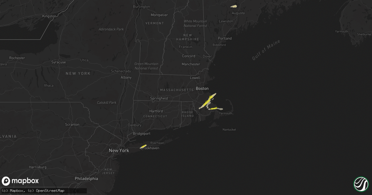
Hail Map in Massachusetts on July 14, 2022
Get this storm
July 14 map
$229
one time, instant access
Download today. No call, no setup
Keep the $229
Bought the map and want the full workflow? Apply the entire $229 to a subscription within 7 days. None of it is wasted.
Every map, not just this one
This buys you this map. Subscription and you get every map we run, in the markets you choose from a few cities to whole states to nationwide. Plus real-time alerts the moment a storm fires.
Contact data
Name, contact info, occupancy, even credit band for addresses in the footprint. You go from where it hit to who to call.
Become the source they trust
Unlimited branding weather history reports on demand. You already have the documented answer ready for the property owner, and you are the one who showed up with it.
Property data and RoofTrace estimates
Pull up any address you have got, its value and the exact code rules for that jurisdiction, straight from One Click Code. Then RoofTrace estimates the squares, pitch, and roof value, priced the way you price.
Storm reports in Massachusetts
Massachusetts
| Date | Description |
|---|---|
| 07/14/20225:45 PM CDT | Fully leafed maple tree branch down on rock harbor road. Relayed by amateur radio. |
| 07/14/20224:50 PM CDT | Nickel and quarter sized hail coated the ground in the marshfield hills section of town. |
| 07/14/20224:30 PM CDT | Top half of tree down on wapping road. Relayed by amateur radio. |
| 07/14/20224:30 PM CDT | A local report indicates 1.00 inch wind near HALIFAX |
| 07/14/20224:30 PM CDT | Reported in the bryantville section of town. Relayed by amateur radio. |
| 07/14/20224:28 PM CDT | Tree down on pleasant street. |
| 07/14/20224:20 PM CDT | Relayed by amateur radio. |
| 07/14/20224:00 PM CDT | Trees and wires down on briarwood drive. Relayed by amateur radio. |
| 07/14/20224:00 PM CDT | Primary power lines down at 1500 block of new state highway |
| 07/14/20223:55 PM CDT | Wires down causing a tree fire. Relayed by amateur radio. |
| 07/14/20221:24 AM CDT | At 624 PM EDT, a severe thunderstorm was located near Brewster, moving east at 35 mph. HAZARD...60 mph wind gusts and quarter size hail. SOURCE...Radar indicated. IMPACT...Expect wind damage to trees and power lines. Minor hail damage to vehicles is possible. Locations impacted include... Brewster, Dennis, Harwich, Orleans, Eastham and Wellfleet. |
| 07/14/202212:43 AM CDT | At 543 PM EDT, a severe thunderstorm was located over Marshfield, moving northeast at 30 mph. HAZARD...60 mph wind gusts and quarter size hail. SOURCE...Public. IMPACT...Expect wind damage to trees and power lines. Minor hail damage to vehicles is possible. Locations impacted include... Marshfield, Scituate, Pembroke, Duxbury, Hanover and Norwell. |
| 07/13/202211:50 PM CDT | At 449 PM EDT, a severe thunderstorm was located near Berkley, or near Taunton, moving east at 30 mph. HAZARD...60 mph wind gusts and quarter size hail. SOURCE...Radar indicated. IMPACT...Expect wind damage to trees and power lines. Minor hail damage to vehicles is possible. Locations impacted include... Plymouth, Taunton, Bridgewater, Marshfield, Middleborough, Wareham, Pembroke, Duxbury, East Bridgewater, Raynham, Kingston, Carver, Lakeville, Hanson, Freetown, Halifax, Dighton, Berkley, Rochester and Plympton. |
All States Impacted by Hail Map on July 14, 2022
Cities Impacted by Hail Map on July 14, 2022
- Steele, ND
- Robinson, ND
- Two Dot, MT
- Martinsdale, MT
- Reform, AL
- Millport, AL
- Lavina, MT
- Mansfield, TX
- Drake, ND
- Anamoose, ND
- Santo, TX
- Crystal River, FL
- Savannah, GA
- Port Wentworth, GA
- Bowie, TX
- Round Mountain, TX
- Willow City, TX
- Johnson City, TX
- Fredericksburg, TX
- Kissimmee, FL
- Middleboro, MA
- Vero Beach, FL
- Okeechobee, FL
- Bradenton, FL
- Oviedo, FL
- Dilley, TX
- Sheyenne, ND
- Saint Michael, ND
- San Antonio, TX
- Dublin, TX
- Gustine, TX
- Pottsville, TX
- Hamilton, TX
- Carlton, TX
- Bastrop, TX
- Bridger, MT
- Roberts, MT
- Columbus, MT
- Lodge Grass, MT
- Joliet, MT
- Fromberg, MT
- Hawthorne, FL
- Helotes, TX
- Gardner, ND
- Audubon, MN
- Lake Park, MN
- Sabin, MN
- Wolverton, MN
- Rothsay, MN
- Pelican Rapids, MN
- Barnesville, MN
- Princeton, MN
- Carver, MA
- Wareham, MA
- Plymouth, MA
- Birney, MT
- Bloomer, WI
- Cushing, MN
- Randall, MN
- Tolna, ND
- Pekin, ND
- Lafayette, AL
- Crowley, TX
- Burleson, TX
- Fort Worth, TX
- Moran, TX
- Cisco, TX
- Warwick, ND
- Oberon, ND
- Bristol, FL
- Rincon, GA
- Guyton, GA
- Bryson, TX
- Hardeeville, SC
- Brook Park, MN
- Hinckley, MN
- Hawley, MN
- Arthur, ND
- Grandin, ND
- Hillsboro, ND
- Argusville, ND
- Hunter, ND
- Harwood, ND
- Casselton, ND
- Galesburg, ND
- Blanchard, ND
- Mapleton, ND
- Goldthwaite, TX
- Park River, ND
- Comanche, TX
- Gorman, TX
- De Leon, TX
- Springfield, GA
- Walterboro, SC
- Manilla, IA
- Irwin, IA
- West, MS
- Saint Cloud, FL
- Eastland, TX
- Ranger, TX
- Comstock, WI
- Cumberland, WI
- Mullin, TX
- Lava Hot Springs, ID
- Dallas, WI
- Barron, WI
- Chetek, WI
- Cameron, WI
- Bancroft, ID
- Midlothian, TX
- Marshfield, MA
- Duxbury, MA
- Baird, TX
- Sarasota, FL
- Durant, MS
- Lexington, MS
- Early, TX
- Brownwood, TX
- Cotulla, TX
- Beatrice, NE
- Wymore, NE
- Blue Springs, NE
- Odell, NE
- Pierz, MN
- Little Falls, MN
- Fort Ripley, MN
- Vining, MN
- Parkers Prairie, MN
- Mount Pleasant, TX
- Mount Vernon, TX
- Ruffin, SC
- Winona, TX
- Kilgore, TX
- Gladewater, TX
- Mertzon, TX
- Carlsbad, TX
- Burkett, TX
- Carbon, TX
- San Saba, TX
- Foreston, MN
- Hillman, MN
- Milaca, MN
- Foley, MN
- Port Charlotte, FL
- Rotonda West, FL
- Englewood, FL
- Mount Dora, FL
- Decker, MT
- Live Oak, FL
- Bronte, TX
- Rochelle, TX
- Roundup, MT
- Cadott, WI
- Lakeville, MA
- Humarock, MA
- Berkley, MA
- Kingston, MA
- Norwell, MA
- Taunton, MA
- East Taunton, MA
- Bridgewater, MA
- Halifax, MA
- North Dighton, MA
- Hanson, MA
- Raynham, MA
- Pembroke, MA
- Dighton, MA
- Plympton, MA
- Farmingville, NY
- Centereach, NY
- Selden, NY
- Islandia, NY
- Central Islip, NY
- Bay Shore, NY
- Holtsville, NY
- Bohemia, NY
- Holbrook, NY
- Brentwood, NY
- Hauppauge, NY
- Nesconset, NY
- Ronkonkoma, NY
- Stephenville, TX
- New York Mills, MN
- Wadena, MN
- Henning, MN
- Deer Creek, MN
- Horace, ND
- Davenport, ND
- Kindred, ND
- West Fargo, ND
- Lima, MT
- Albany, TX
- Gold Creek, MT
- Brashear, TX
- Sulphur Springs, TX
- Blackwell, TX
- West Wareham, MA
- Rochester, MA
- Belgrade, ME
- Mount Vernon, ME
- Kents Hill, ME
- Grass Range, MT
- Winnett, MT
- Almena, WI
- Leesville, LA
- Crown King, AZ
- Clarendon, NC
- Tabor City, NC
- Granbury, TX
- Mora, MN
- Pine City, MN
- Grantsburg, WI
- Varnville, SC
- Apopka, FL
- Dolan Springs, AZ
- Red Oak, TX
- Lancaster, TX
- Ferris, TX
- Grand Prairie, TX
- Waxahachie, TX
- Arlington, TX
- Cedar Hill, TX
- Alvarado, TX
- Palmer, TX
- Venus, TX
- Desoto, TX
- Winter Garden, FL
- San Angelo, TX
- Coleman, TX
- Valera, TX
- Talpa, TX
- Novice, TX
- Lucedale, MS
- Orlando, FL
- Pearsall, TX
- Sweetwater, TX
- Turtle Lake, WI
- Jacksboro, TX
- Flagstaff, AZ
- Zephyr, TX
- Pisek, ND
- Buchanan Dam, TX
- Kingsland, TX
- Llano, TX
- Peach Springs, AZ
- Rowlett, TX
- Garland, TX
- Saint Croix Falls, WI
- Princeton, ME
- Onamia, MN
- Cleburne, TX
- Okatie, SC
- Bluffton, SC
- Tucson, AZ
- Ovalo, TX
- Clyde, TX
- Rush City, MN
- New Waverly, TX
- Huntsville, TX
- Hickman, NE
- Sterling, NE
- Firth, NE
- Adams, NE
- Sorrento, FL
- Beeville, TX
- Three Rivers, TX
- Robert Lee, TX
- Dalbo, MN
- McCool, MS
- Weir, MS
- Zolfo Springs, FL
- Clewiston, FL
- Labelle, FL
- Umatilla, FL
- Cedar Creek, TX
- Elgin, TX
- East Bridgewater, MA
- Lometa, TX
- Bend, TX
- Geneva, FL
- Goliad, TX
- Moore, TX
- Indiantown, FL
- Cape Coral, FL
- Falls City, TX
- Lampasas, TX
- Cross Plains, TX
- Casselberry, FL
- Lake Grove, NY
- Fort Totten, ND
- Scituate, MA
- Musselshell, MT


