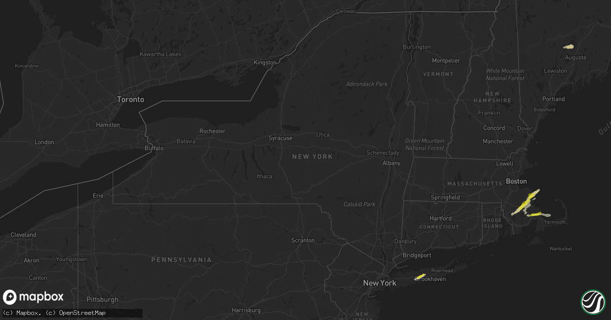
Hail Map in New York on July 14, 2022
Get this storm
July 14 map
$229
one time, instant access
Download today. No call, no setup
Keep the $229
Bought the map and want the full workflow? Apply the entire $229 to a subscription within 7 days. None of it is wasted.
Every map, not just this one
This buys you this map. Subscription and you get every map we run, in the markets you choose from a few cities to whole states to nationwide. Plus real-time alerts the moment a storm fires.
Contact data
Name, contact info, occupancy, even credit band for addresses in the footprint. You go from where it hit to who to call.
Become the source they trust
Unlimited branding weather history reports on demand. You already have the documented answer ready for the property owner, and you are the one who showed up with it.
Property data and RoofTrace estimates
Pull up any address you have got, its value and the exact code rules for that jurisdiction, straight from One Click Code. Then RoofTrace estimates the squares, pitch, and roof value, priced the way you price.
Storm reports in New York
New York
| Date | Description |
|---|---|
| 07/14/20225:53 PM CDT | Tree down on clunan drive in coram. |
| 07/14/20225:44 PM CDT | Wires down and in flames on middle country road and south coleman road in centereach. |
| 07/14/20225:44 PM CDT | A local report indicates 1.25 inch wind near 1 WSW SELDEN |
| 07/14/20225:44 PM CDT | Wires down and in flames on middle c |
| 07/14/20225:42 PM CDT | Picture of quarter sized hail. |
| 07/14/20225:42 PM CDT | Pictures of large tree limbs down on road. Power was lost. |
| 07/14/20225:38 PM CDT | Tree down on powerlines near portion road and college road in farmingville. |
| 07/14/20225:36 PM CDT | Tree on house on smith street in lake ronkonkoma. |
| 07/14/20225:35 PM CDT | Tree down on house and car on dorchester road in lake ronkonkoma. |
| 07/14/20225:35 PM CDT | Numerous large tree branches and several tree tops snapped off in the area of sachem north high school and smith street. |
| 07/14/20225:30 PM CDT | Tree down on 7-eleven on corner of metzner road and smithtown blvd. |
| 07/14/20225:20 PM CDT | Tree and large limbs down near motor parkway and blydenburg road in hauppague. |
| 07/14/20221:28 AM CDT | At 628 PM EDT, a severe thunderstorm was located over Ronkonkoma, moving northeast at 25 mph. HAZARD...Quarter size hail. SOURCE...Radar indicated. IMPACT...Minor damage to vehicles is possible. This severe thunderstorm will be near... Farmingville around 635 PM EDT. Medford around 640 PM EDT. Coram and Mount Sinai around 645 PM EDT. Middle Island around 650 PM EDT. Rocky Point around 655 PM EDT. Brookhaven National Laboratory around 700 PM EDT. Wading River around 710 PM EDT. Calverton around 715 PM EDT. |
All States Impacted by Hail Map on July 14, 2022
Cities Impacted by Hail Map on July 14, 2022
- Steele, ND
- Robinson, ND
- Two Dot, MT
- Martinsdale, MT
- Reform, AL
- Millport, AL
- Lavina, MT
- Mansfield, TX
- Drake, ND
- Anamoose, ND
- Santo, TX
- Crystal River, FL
- Savannah, GA
- Port Wentworth, GA
- Bowie, TX
- Round Mountain, TX
- Willow City, TX
- Johnson City, TX
- Fredericksburg, TX
- Kissimmee, FL
- Middleboro, MA
- Vero Beach, FL
- Okeechobee, FL
- Bradenton, FL
- Oviedo, FL
- Dilley, TX
- Sheyenne, ND
- Saint Michael, ND
- San Antonio, TX
- Dublin, TX
- Gustine, TX
- Pottsville, TX
- Hamilton, TX
- Carlton, TX
- Bastrop, TX
- Bridger, MT
- Roberts, MT
- Columbus, MT
- Lodge Grass, MT
- Joliet, MT
- Fromberg, MT
- Hawthorne, FL
- Helotes, TX
- Gardner, ND
- Audubon, MN
- Lake Park, MN
- Sabin, MN
- Wolverton, MN
- Rothsay, MN
- Pelican Rapids, MN
- Barnesville, MN
- Princeton, MN
- Carver, MA
- Wareham, MA
- Plymouth, MA
- Birney, MT
- Bloomer, WI
- Cushing, MN
- Randall, MN
- Tolna, ND
- Pekin, ND
- Lafayette, AL
- Crowley, TX
- Burleson, TX
- Fort Worth, TX
- Moran, TX
- Cisco, TX
- Warwick, ND
- Oberon, ND
- Bristol, FL
- Rincon, GA
- Guyton, GA
- Bryson, TX
- Hardeeville, SC
- Brook Park, MN
- Hinckley, MN
- Hawley, MN
- Arthur, ND
- Grandin, ND
- Hillsboro, ND
- Argusville, ND
- Hunter, ND
- Harwood, ND
- Casselton, ND
- Galesburg, ND
- Blanchard, ND
- Mapleton, ND
- Goldthwaite, TX
- Park River, ND
- Comanche, TX
- Gorman, TX
- De Leon, TX
- Springfield, GA
- Walterboro, SC
- Manilla, IA
- Irwin, IA
- West, MS
- Saint Cloud, FL
- Eastland, TX
- Ranger, TX
- Comstock, WI
- Cumberland, WI
- Mullin, TX
- Lava Hot Springs, ID
- Dallas, WI
- Barron, WI
- Chetek, WI
- Cameron, WI
- Bancroft, ID
- Midlothian, TX
- Marshfield, MA
- Duxbury, MA
- Baird, TX
- Sarasota, FL
- Durant, MS
- Lexington, MS
- Early, TX
- Brownwood, TX
- Cotulla, TX
- Beatrice, NE
- Wymore, NE
- Blue Springs, NE
- Odell, NE
- Pierz, MN
- Little Falls, MN
- Fort Ripley, MN
- Vining, MN
- Parkers Prairie, MN
- Mount Pleasant, TX
- Mount Vernon, TX
- Ruffin, SC
- Winona, TX
- Kilgore, TX
- Gladewater, TX
- Mertzon, TX
- Carlsbad, TX
- Burkett, TX
- Carbon, TX
- San Saba, TX
- Foreston, MN
- Hillman, MN
- Milaca, MN
- Foley, MN
- Port Charlotte, FL
- Rotonda West, FL
- Englewood, FL
- Mount Dora, FL
- Decker, MT
- Live Oak, FL
- Bronte, TX
- Rochelle, TX
- Roundup, MT
- Cadott, WI
- Lakeville, MA
- Humarock, MA
- Berkley, MA
- Kingston, MA
- Norwell, MA
- Taunton, MA
- East Taunton, MA
- Bridgewater, MA
- Halifax, MA
- North Dighton, MA
- Hanson, MA
- Raynham, MA
- Pembroke, MA
- Dighton, MA
- Plympton, MA
- Farmingville, NY
- Centereach, NY
- Selden, NY
- Islandia, NY
- Central Islip, NY
- Bay Shore, NY
- Holtsville, NY
- Bohemia, NY
- Holbrook, NY
- Brentwood, NY
- Hauppauge, NY
- Nesconset, NY
- Ronkonkoma, NY
- Stephenville, TX
- New York Mills, MN
- Wadena, MN
- Henning, MN
- Deer Creek, MN
- Horace, ND
- Davenport, ND
- Kindred, ND
- West Fargo, ND
- Lima, MT
- Albany, TX
- Gold Creek, MT
- Brashear, TX
- Sulphur Springs, TX
- Blackwell, TX
- West Wareham, MA
- Rochester, MA
- Belgrade, ME
- Mount Vernon, ME
- Kents Hill, ME
- Grass Range, MT
- Winnett, MT
- Almena, WI
- Leesville, LA
- Crown King, AZ
- Clarendon, NC
- Tabor City, NC
- Granbury, TX
- Mora, MN
- Pine City, MN
- Grantsburg, WI
- Varnville, SC
- Apopka, FL
- Dolan Springs, AZ
- Red Oak, TX
- Lancaster, TX
- Ferris, TX
- Grand Prairie, TX
- Waxahachie, TX
- Arlington, TX
- Cedar Hill, TX
- Alvarado, TX
- Palmer, TX
- Venus, TX
- Desoto, TX
- Winter Garden, FL
- San Angelo, TX
- Coleman, TX
- Valera, TX
- Talpa, TX
- Novice, TX
- Lucedale, MS
- Orlando, FL
- Pearsall, TX
- Sweetwater, TX
- Turtle Lake, WI
- Jacksboro, TX
- Flagstaff, AZ
- Zephyr, TX
- Pisek, ND
- Buchanan Dam, TX
- Kingsland, TX
- Llano, TX
- Peach Springs, AZ
- Rowlett, TX
- Garland, TX
- Saint Croix Falls, WI
- Princeton, ME
- Onamia, MN
- Cleburne, TX
- Okatie, SC
- Bluffton, SC
- Tucson, AZ
- Ovalo, TX
- Clyde, TX
- Rush City, MN
- New Waverly, TX
- Huntsville, TX
- Hickman, NE
- Sterling, NE
- Firth, NE
- Adams, NE
- Sorrento, FL
- Beeville, TX
- Three Rivers, TX
- Robert Lee, TX
- Dalbo, MN
- McCool, MS
- Weir, MS
- Zolfo Springs, FL
- Clewiston, FL
- Labelle, FL
- Umatilla, FL
- Cedar Creek, TX
- Elgin, TX
- East Bridgewater, MA
- Lometa, TX
- Bend, TX
- Geneva, FL
- Goliad, TX
- Moore, TX
- Indiantown, FL
- Cape Coral, FL
- Falls City, TX
- Lampasas, TX
- Cross Plains, TX
- Casselberry, FL
- Lake Grove, NY
- Fort Totten, ND
- Scituate, MA
- Musselshell, MT


